Google Earth
And here are all the sites on an interactive Google Earth project. earth.google.com/earth/d/1FDs...
I will add to this link if any new data becomes available too.
07.05.2025 13:47 — 👍 41 🔁 5 💬 1 📌 0


Overall, here are all the sites on a map.
07.05.2025 13:46 — 👍 45 🔁 3 💬 1 📌 0

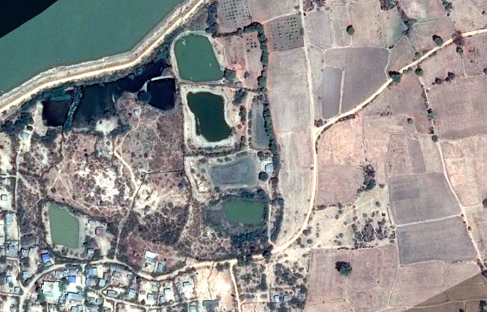
9. 'Sawai Nala' Camp.
Approx. 34.391064°N 73.449336°E
google.com/maps/place/3...
This is the one site that has not been presented as either a slide or a handout by the IAF, so its exact location is impossible to pinpoint; it appears to be around here.
Can't say much else.
07.05.2025 13:46 — 👍 22 🔁 1 💬 1 📌 0
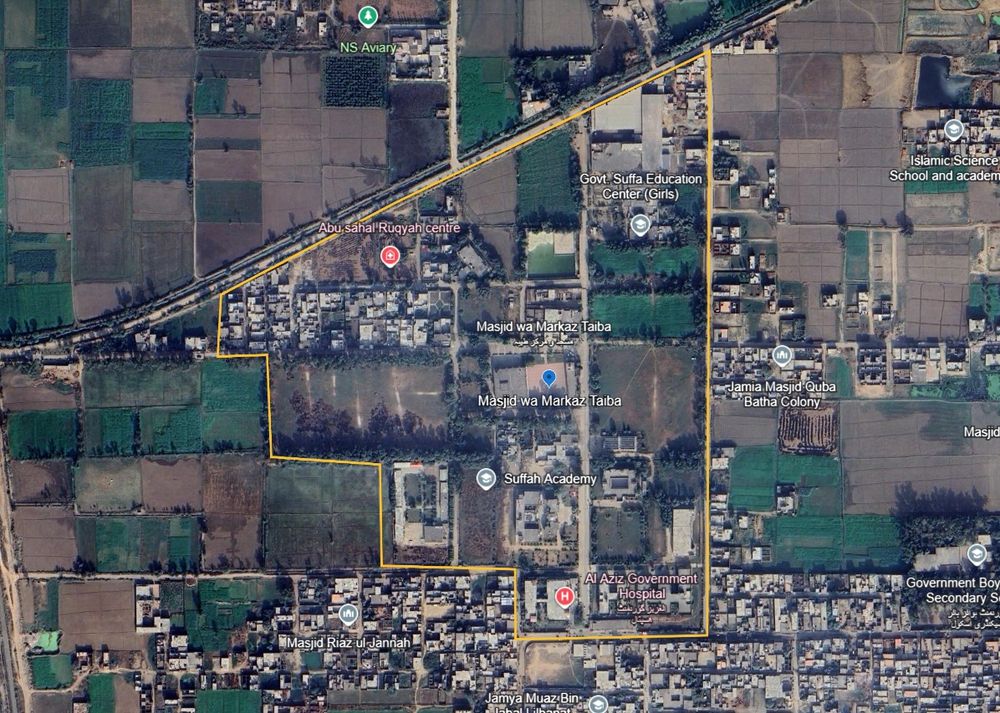

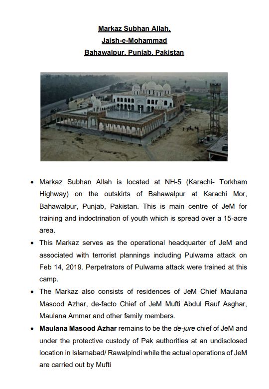
7. Masjid wa Markaz Taiba
31.838263°N 74.259836°E
google.com/maps/place/3...
The perimeter as mapped includes a hospital and several schools and colleges.
The strike imagery is distant but appears to show a pretty much a hit on the Masjid, perhaps slightly to the north-west.
07.05.2025 13:45 — 👍 23 🔁 1 💬 1 📌 0
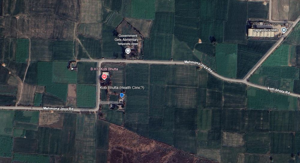

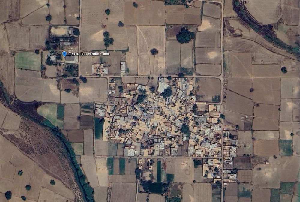
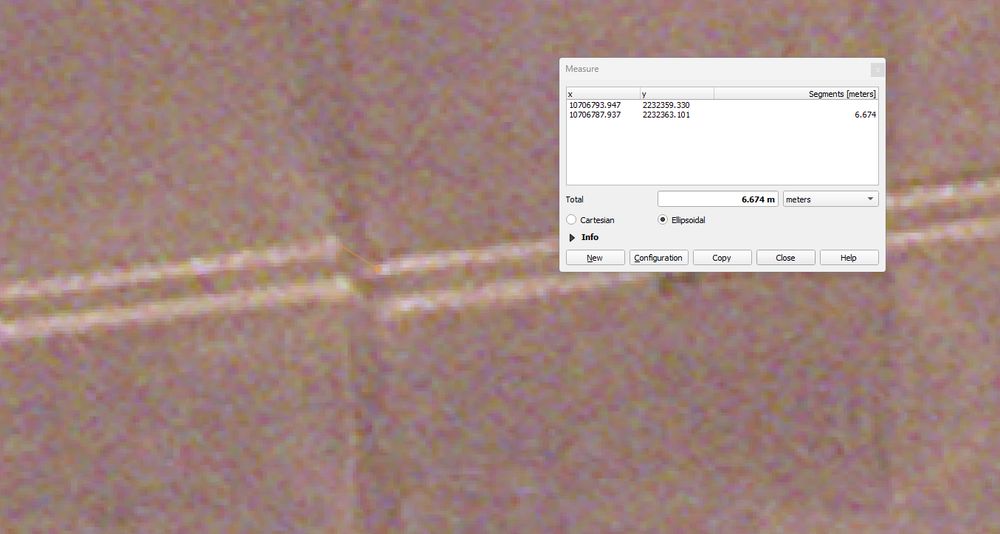
6. Kotli Butta site (health clinic?) 32.617123°N 74.505696°E google.com/maps/place/3...
Google calls this a Basic Health Unit site, but with no pictures or reviews. It is not listed on HDX's health-sites database or OSM. So I'm really not sure, some sources called it a 'seminary'.
07.05.2025 13:45 — 👍 28 🔁 1 💬 1 📌 0
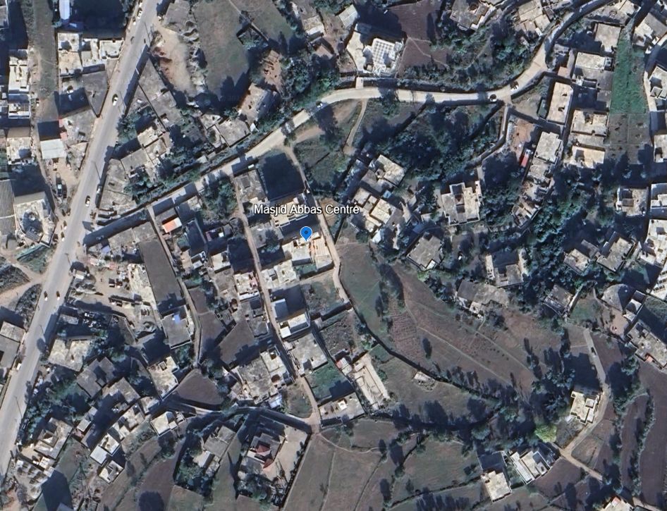

4. Masjid Abbas in Kotli
33.508495°N 73.906416°E
google.com/maps/place/3...
The strike-vision provided is too distant to determine the exact impact, but no reason to think it hit anything but the target.
07.05.2025 13:43 — 👍 34 🔁 3 💬 1 📌 0
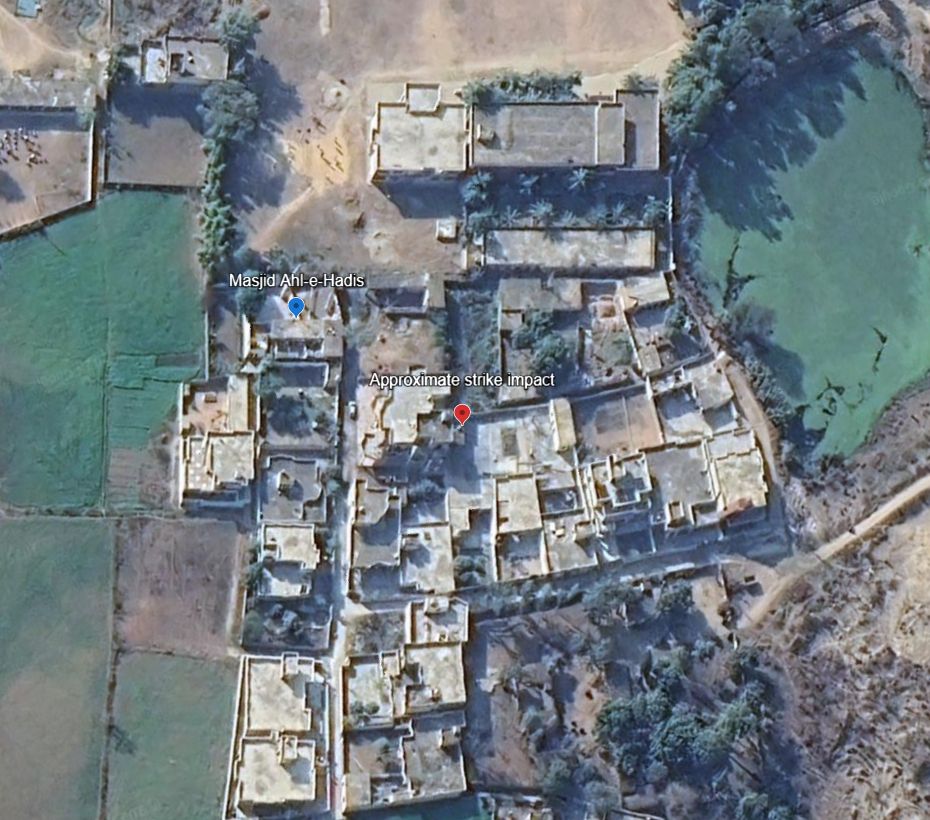

3. Masjid Ahl-e-Hadis in Barnala, Bhimber.
32.867802°N 74.256469°E
google.com/maps/place/3...
Quadcopter-dropped munition appear to miss the target building and strike a courtyard around 50m away.
07.05.2025 13:43 — 👍 37 🔁 3 💬 1 📌 0
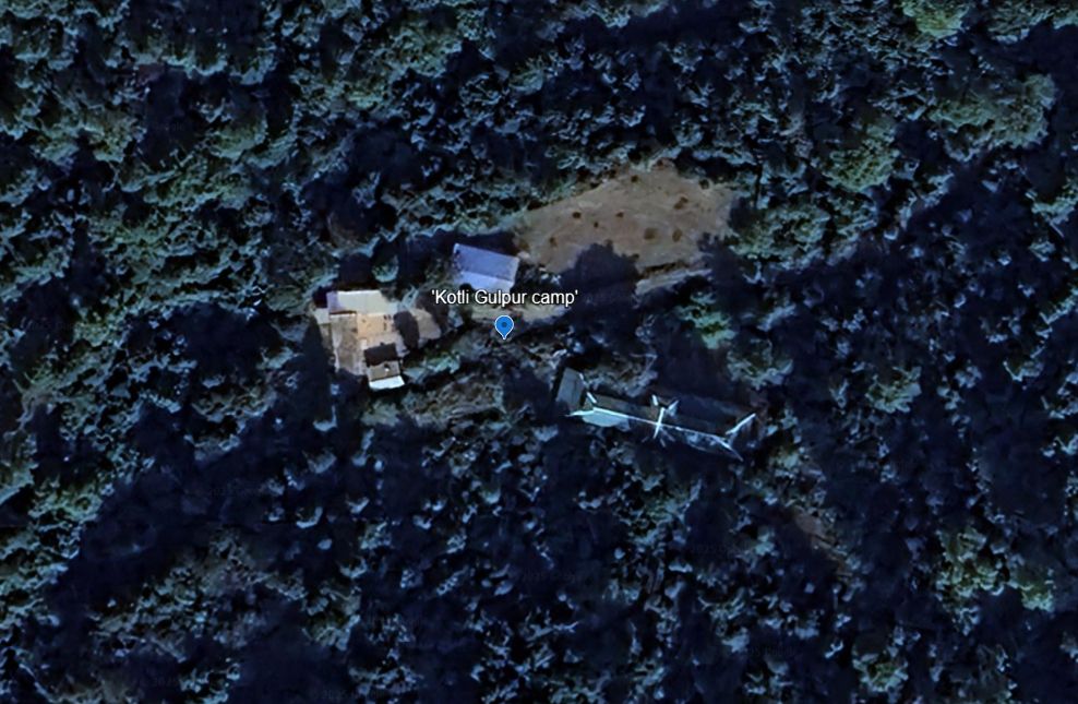
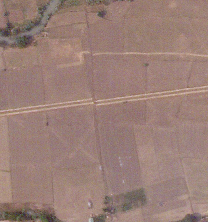
2. Reported training camp in Gulpur, Kotli
33.402328°N 73.876957°E
No post-strike imagery yet.
google.com/maps/place/3...
07.05.2025 13:42 — 👍 38 🔁 3 💬 1 📌 0
🧵Geolocations of ALL sites that the Indian Army has claimed to have hit in Pakistan and Kashmir.
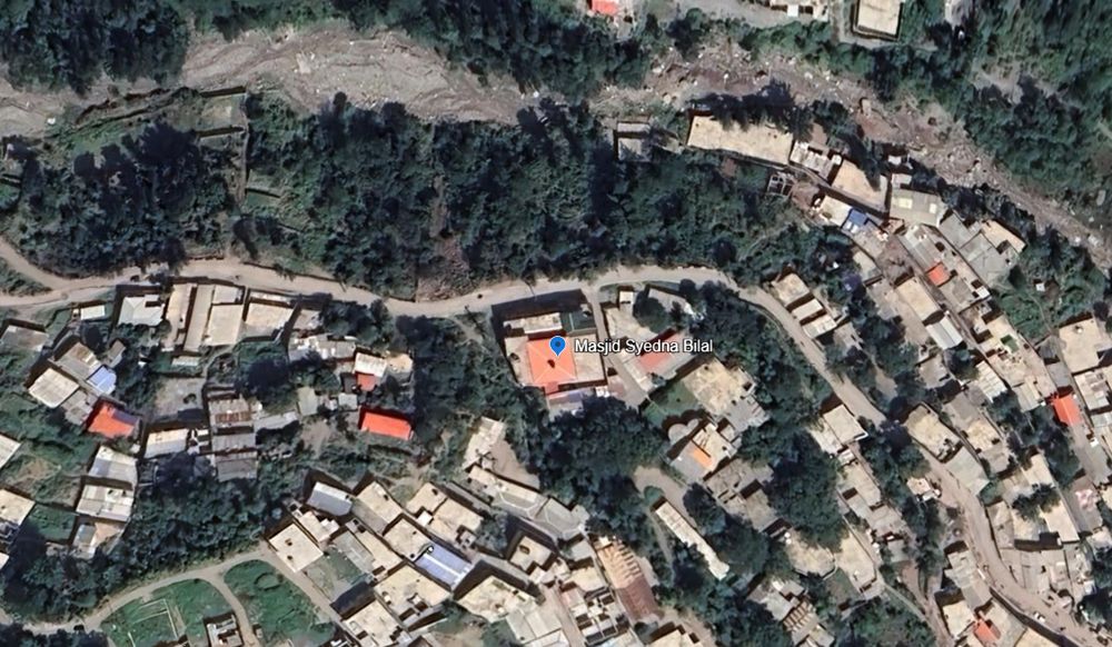
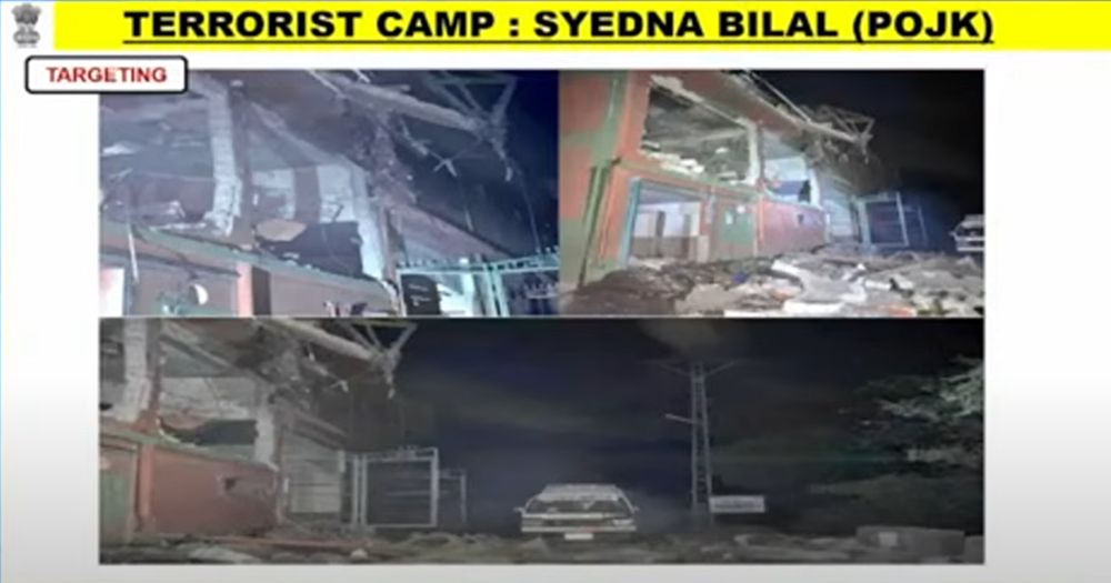
1. Masjid Syedna Bilal/Hazrat Bilal
34.385846°N 73.456974°E
It appears to have been a direct hit, according to after-strike ground photos.
google.com/maps/place/3...
07.05.2025 13:42 — 👍 119 🔁 33 💬 1 📌 3

Further south, the main road from the airport to Naypyidaw has deformed and been damaged. www.google.com/maps/place/1...
03.04.2025 00:31 — 👍 17 🔁 2 💬 0 📌 0


In the barracks of Naypyidaw airbase, you can see a building that has split down the middle with the rupture. www.google.com/maps/place/1...
03.04.2025 00:29 — 👍 16 🔁 3 💬 1 📌 0
The new satellite imagery to the right of the surface rupture is perfectly aligned with the historical Google imagery. On the left, you can see the rupture and offset.
02.04.2025 13:28 — 👍 34 🔁 11 💬 1 📌 1
various open data programs by satellite companies, that map is mostly Planet imagery, but I've also been looking at Maxar and Airbus released imagery
31.03.2025 05:09 — 👍 1 🔁 0 💬 0 📌 0
Yep, just by hand and visual interpretation. Unfortunately I've just had time to manually identify the damage points and not add metadata yet. EERI is welcome to any of it though!
31.03.2025 04:52 — 👍 1 🔁 0 💬 1 📌 0
If you're using this in published media reports, please credit Nathan Ruser / ASPI - credit is not necessary for other uses.
31.03.2025 04:06 — 👍 10 🔁 0 💬 0 📌 0
The IDP mapping is a late addition so it is not as comprehensive yet as everything else, but working on it.
No imagery is available yet for most of East Mandalay City or Naypyidaw. I will add it whenever possible.
31.03.2025 04:05 — 👍 12 🔁 0 💬 1 📌 0
In total it shows around 140 structures damaged/destroyed (excluding ~330 destroyed by fire - not mapped per structure).
It has around 60 high-priority rescue sites where large apartment complexes have collapsed, or gathering places (mosques, schools, monasteries etc.) have been destroyed.
31.03.2025 03:51 — 👍 13 🔁 2 💬 1 📌 0
ANY organisation or individual is welcome to download and use this data for any purpose, especially if it can assist in rescue and recovery efforts.
31.03.2025 03:51 — 👍 11 🔁 0 💬 1 📌 0
Myanmar Earthquake Damage - Google My Maps
ANY organisation can use this data for any purpose.
Notes on methodology:
Destroyed locations:
All identified destroyed/damaged sites have been identified from satellite imagery. The sites were dete...
I've been going through the imagery and mapping any destroyed/damaged structure, particular rescue priorities (potential mass casualty events) and IDP locations in all the imagery available.
google.com/maps/d/edit?...
Please check the map and share widely with anyone who will find it useful.
31.03.2025 03:50 — 👍 58 🔁 33 💬 2 📌 0
What we’re witnessing in America is what happens when disordered discourse captures a political party, then the state itself. The Republican Party was the first to fall - abandoning truth for conspiracy, ideology for grievance, and policy for performative outrage.
28.02.2025 21:47 — 👍 10500 🔁 2849 💬 171 📌 345


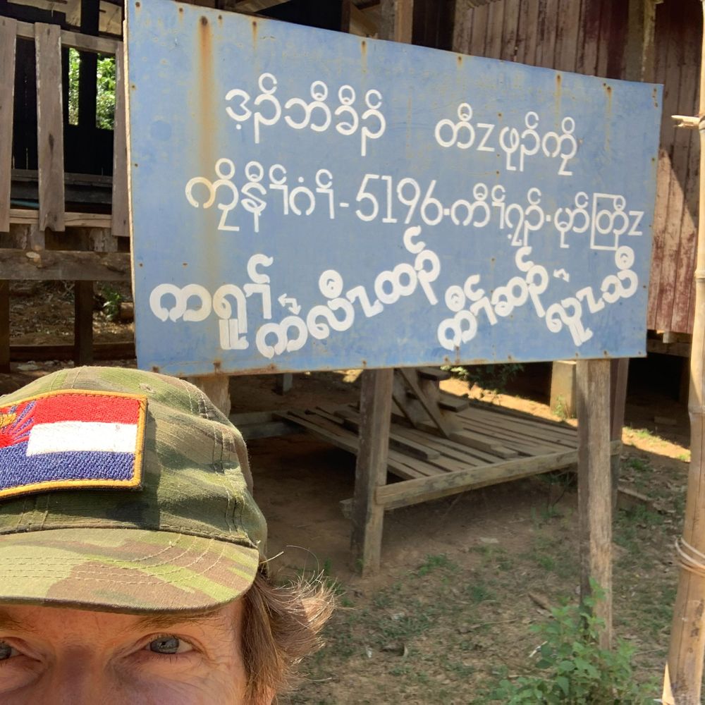
Here are two neighbouring villages in Burma, the first under Resistance Control, the second under Military Junta control. Where would you prefer to live?
25.02.2025 08:23 — 👍 24 🔁 4 💬 0 📌 0

Recent satellite imagery from Jan shows the resistance-aligned Kachin Independence Army establishing fortified frontlines on the outskirts of the Kachin capital, Myitkyina (close to Waingmaw town). For much of the war, the resistance has been asymmetrical. Now not as much.
25.02.2025 07:41 — 👍 33 🔁 0 💬 1 📌 0

Photos of captured ammo show that ammo manufactured as recently as last month is already appearing on the battlefield. The capture, destruction or disruption of Junta ammo factories would have major, nationwide ramifications almost immediately.
23.02.2025 09:31 — 👍 35 🔁 3 💬 0 📌 0
Note that the map of captures only shows the border outposts in Karenni that were captured, and not the vast number of positions elsewhere in the state and nearby.
14.02.2025 14:24 — 👍 12 🔁 0 💬 1 📌 0
Data for Myanmar is an independent organization that provides useful data for the people in Myanmar
An independent, bilingual Myanmar news agency delivering insightful stories.
Min Aung Hlaing Ma A Loe. Ma A Loe Min Aung Hlaing
Free Syria. Sources provided.
Supporting the revolution for federal democracy in Myanmar
#WhatsHappeningInMyanmar
I love solidarity . books . mutual aid . equity . collective liberation
📝 Journalist(e)
🌿 Nat Geo Explorer
🎥 Filmmaker
www.melaniegouby.com
Professor, journalist, political analyst, cynical optimist —- Public speaker via London Speakers Bureau
Australia Director at Human Rights Watch @hrw
Citizen journalist in active Burma revolution zones
senior reporter @ WIRED covering the politics and power influencing the internet
DMs open, Signal: makenakelly.32
FAQ, Instagram, TikTok, & everything else at linktr.ee/makenakelly
NIKKEI, Visual Journalist
video and photo analysis, photography, and 3D reconstruction.
Londoner. CBRN expert, particularly nerve agents. Freeman of the City of London. Liveryman. "Legal Juggernaut". Anglican. Ex Verger. Author. Fellow of the Royal Historical Society. Scourge of llamas. Former US Army. Former USSS. #NAFO Fella
Author "The Road from Damascus". Co-author "Burning Country: Syrians in Revolution and War". Writer and deputy editor at the Critical Muslim. English editor at www.isisprisons.museum. Journalism etc collected at www.qunfuz.com
Journalist - Analyst Conflict zones, terrorism, and security
Bylines at @MiddleEastEye @AJStudies @ActaFabulae
Circassian
Director of Journalism, University of Essex; Associate Editor, New Lines Magazine; Contributing Editor, LA Review of Books; Bylines: New York Review of Books, Times Literary Supplement, Foreign Policy, The Observer, Washington Post.
Freelance Syrian conflict reporter and researcher, bomb survivor, covering the ongoing crisis in Syria. Previous research assistant @columbia.
Coffee: https://ko-fi.com/faredalmahlool
Ukraine correspondent. British-Lebanese conflict journalist & filmmaker. Director of The Battle For Kyiv. Interested in human rights. RTs ≠ endorsement.
https://ko-fi.com/ozkaterji
Associate Professor (Uyghur homeland, ethnic policy in China); Tibetan pop music translator; organizer of "Tibetan Separatist Activities" according to ChinaDaily