Another year is about to head into the books and I’m looking for this year to be over. Wasn’t a great year for me in the grand scheme. Some good, but a lot of meh or terrible.
Been a while since things have been truly great for me. Hopefully someday that will change.
Goodbye 2024
31.12.2024 03:02 —
👍 1
🔁 0
💬 0
📌 0
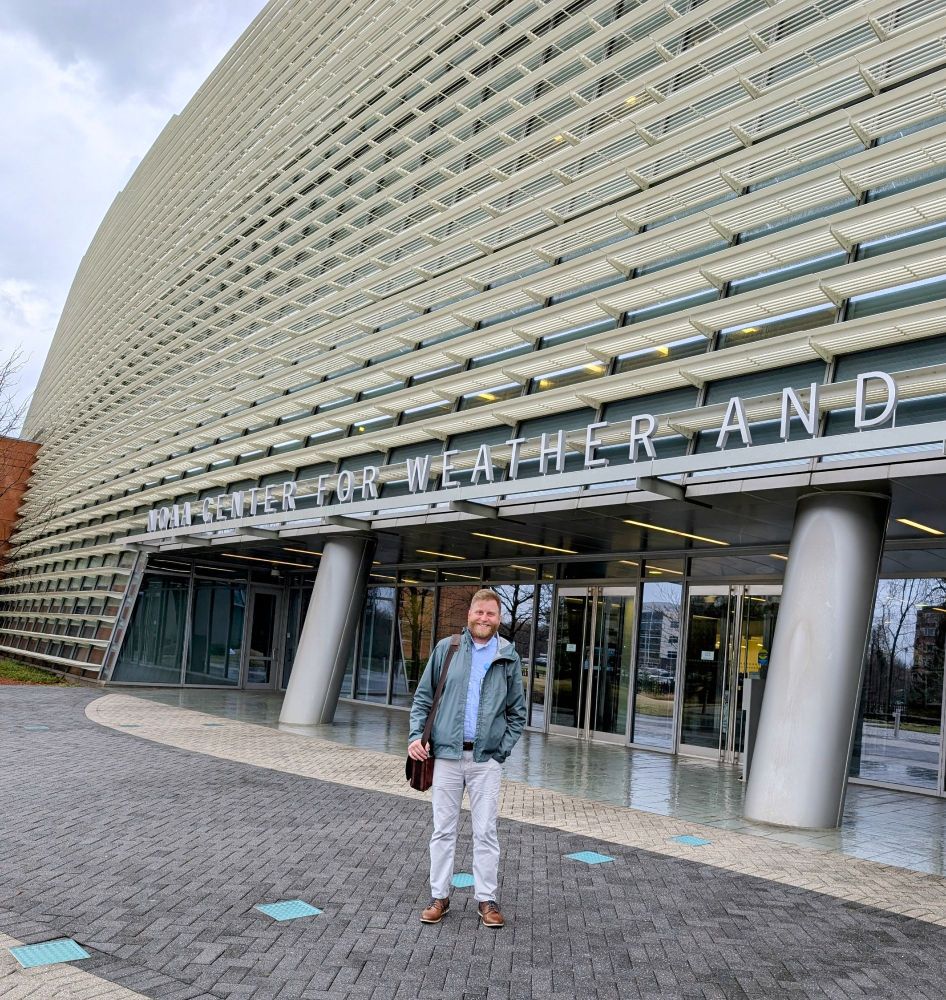
Got to visit the NCWCP (NOAA Center for Weather and Climate Prediction) in Maryland earlier this month. So proud of the work that I'm doing for the NWS.
24.12.2024 20:48 —
👍 8
🔁 1
💬 0
📌 0
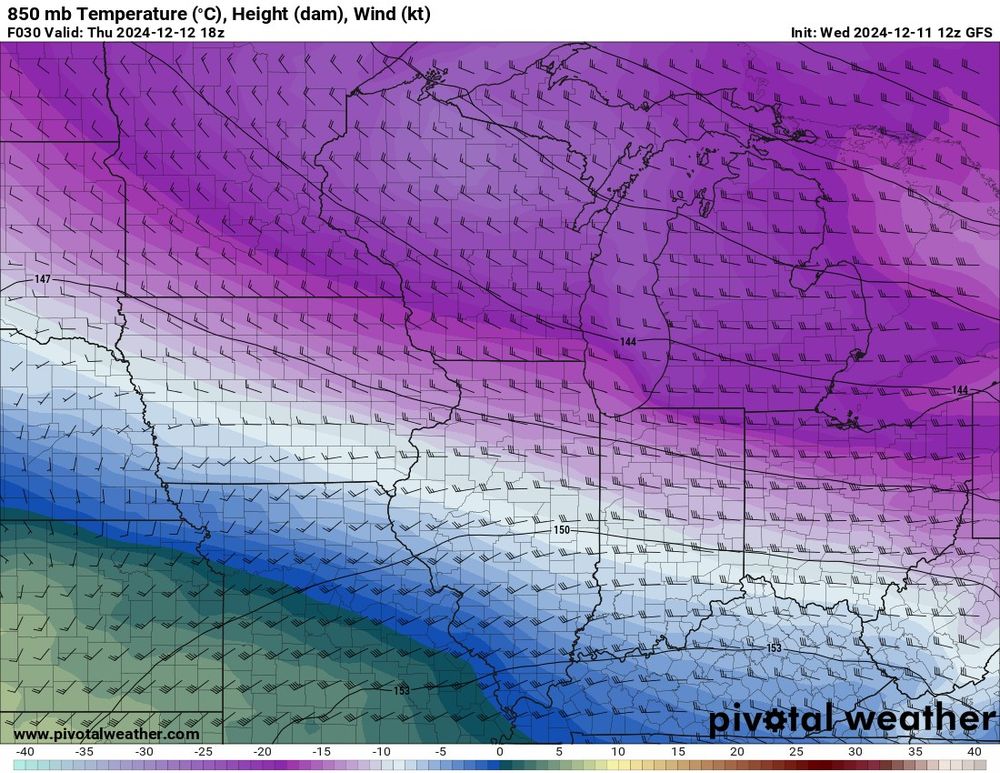
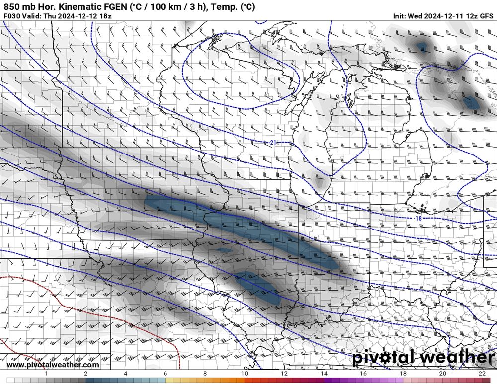
Tomorrow, models indicate that a narrow, east-west oriented frontogenetically forced band of snow will develop across central Illinois in a broad deformation pattern. 1/4
11.12.2024 16:03 —
👍 16
🔁 2
💬 3
📌 0

Mushroom is the UK's most liked pizza topping
Generally speaking, which of the following toppings do you like on a pizza? Select as many as you like
42% Sweetcorn
60% Peppers
49% Bacon
56% Pepperoni
26% Spinach
33% Olives
42% Pineapple
51% Tomato (as a topping)
61% Ham
65% Mushrooms
Other items not depicted include; onions (62%), chicken (56%), beef (36%), chillies (31%), jalapeños (30%), pork (25%), tuna (22%), anchovies (18%), 2% of people say they only like Margherita pizzas
Who wants to see the worst pie chart of the year #dataviz
12.12.2024 23:21 —
👍 717
🔁 223
💬 92
📌 121
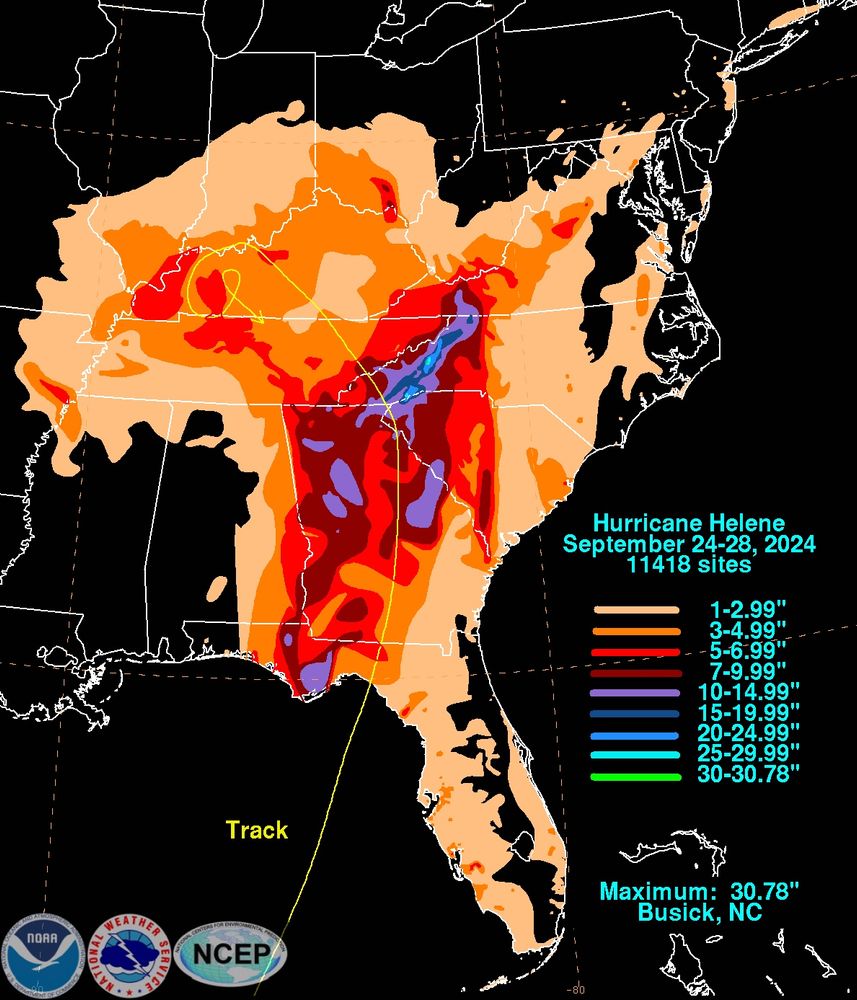
The preliminary Helene (2024) rainfall graphics are available.
This one is here: www.wpc.ncep.noaa.gov/tropical/rai...
12.12.2024 21:59 —
👍 147
🔁 56
💬 10
📌 5
Wet. Details at 11
09.12.2024 02:56 —
👍 1
🔁 0
💬 0
📌 0
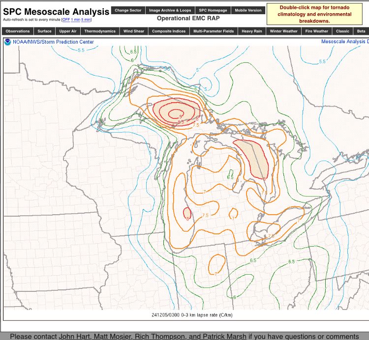
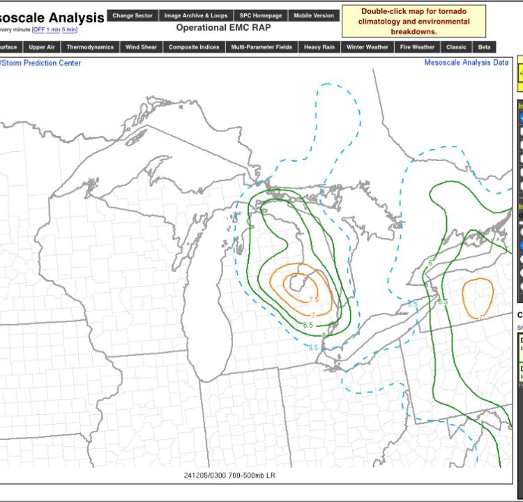
This is a truly classic snow squall event unfolding for the Great Lakes, Ohio Valley, into the Mid Atlantic. Those low to mid level lapse rates are pretty wicked. Michigan pretty much exhibiting one of the better environments for significant snow squall potential at any point in the season.
05.12.2024 03:23 —
👍 4
🔁 0
💬 0
📌 0
Following immediately due to line #2
04.12.2024 13:33 —
👍 2
🔁 0
💬 0
📌 0
@wxmvpete.bsky.social You have a fan!
04.12.2024 13:32 —
👍 3
🔁 0
💬 0
📌 0
Once the shortwave ejection out of Ontario rounds the base of the ULL over Canada, that band will fully mature and then off we go to a mega band that will likely push 4”/hr in spots between Adams Center to Watertown. The show is just now starting.
Good showing, Matt!
30.11.2024 02:56 —
👍 6
🔁 0
💬 0
📌 0
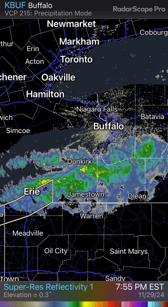
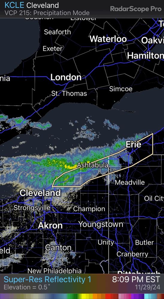
The event going on across the southern Lake Erie shores and just inland will be remembered by many living in the area. Totals over 4’ are looking increasingly likely from NE Ohio all the way to the Buffalo Southtowns near Hamburg and surrounds.
30.11.2024 02:53 —
👍 7
🔁 1
💬 1
📌 0
Hello fellow National Center fren 🙂
28.11.2024 04:01 —
👍 0
🔁 0
💬 1
📌 0
We JUST fell short of the 18” mark out in Western MD and Northern WV. Lots of 12-17” totals out in Garrett Co. down through Tucker Co. in WV. Quite a good start to the winter season out in those parts.
23.11.2024 21:24 —
👍 1
🔁 0
💬 0
📌 0
Quite the event in the terrain of PA/MD/WV with this system. Wouldn’t be surprised to see some 18-22” totals in the primed upslope areas of the mountains of Western PA down through Western MD and Northern WV.
22.11.2024 22:31 —
👍 2
🔁 0
💬 0
📌 1
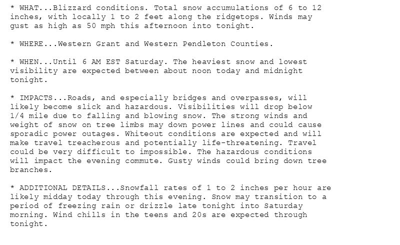
* WHAT...Blizzard conditions. Total snow accumulations of 6 to 12
inches, with locally 1 to 2 feet along the ridgetops. Winds may
gust as high as 50 mph this afternoon into tonight.
* WHERE...Western Grant and Western Pendleton Counties.
* WHEN...Until 6 AM EST Saturday. The heaviest snow and lowest
visibility are expected between about noon today and midnight
tonight.
* IMPACTS...Roads, and especially bridges and overpasses, will
likely become slick and hazardous. Visibilities will drop below
1/4 mile due to falling and blowing snow. The strong winds and
weight of snow on tree limbs may down power lines and could cause
sporadic power outages. Whiteout conditions are expected and will
make travel treacherous and potentially life-threatening. Travel
could be very difficult to impossible. The hazardous conditions
will impact the evening commute. Gusty winds could bring down tree
branches.
* ADDITIONAL DETAILS...Snowfall rates of 1 to 2 inches per hour are
likely midday today through this evening. Snow may transition to a
period of freezing rain or drizzle late tonight into Saturday
morning. Wind chills in the teens and 20s are expected through
tonight.
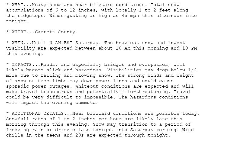
* WHAT...Heavy snow and near blizzard conditions. Total snow
accumulations of 6 to 12 inches, with locally 1 to 2 feet along
the ridgetops. Winds gusting as high as 45 mph this afternoon into
tonight.
* WHERE...Garrett County.
* WHEN...Until 3 AM EST Saturday. The heaviest snow and lowest
visibility are expected between about 10 AM this morning and 10 PM
this evening.
* IMPACTS...Roads, and especially bridges and overpasses, will
likely become slick and hazardous. Visibilities may drop below 1/4
mile due to falling and blowing snow. The strong winds and weight
of snow on tree limbs may down power lines and could cause
sporadic power outages. Whiteout conditions are expected and will
make travel treacherous and potentially life-threatening. Travel
could be very difficult to impossible. The hazardous conditions
will impact the evening commute.
* ADDITIONAL DETAILS...Near blizzard conditions are possible today.
Snowfall rates of 1 to 2 inches per hour are likely late this
morning through this evening. Snow may transition to a period of
freezing rain or drizzle late tonight into Saturday morning. Wind
chills in the teens and 20s are expected through tonight.
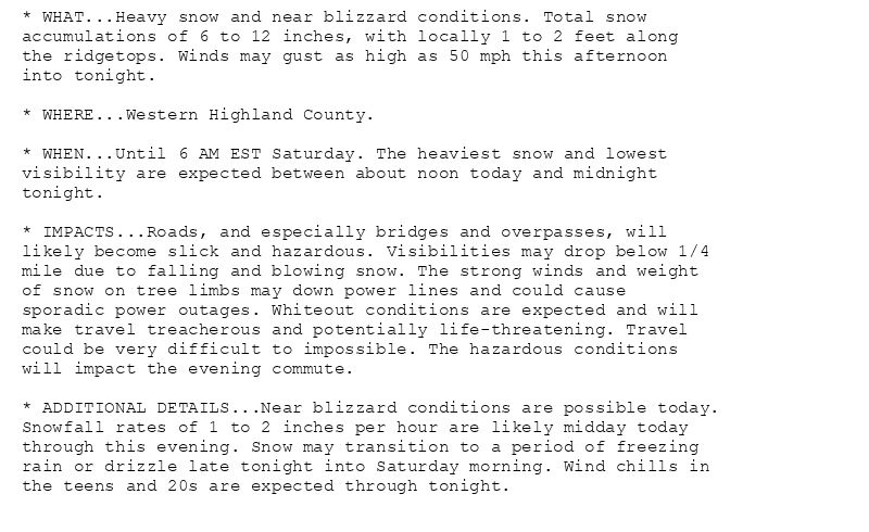
* WHAT...Heavy snow and near blizzard conditions. Total snow
accumulations of 6 to 12 inches, with locally 1 to 2 feet along
the ridgetops. Winds may gust as high as 50 mph this afternoon
into tonight.
* WHERE...Western Highland County.
* WHEN...Until 6 AM EST Saturday. The heaviest snow and lowest
visibility are expected between about noon today and midnight
tonight.
* IMPACTS...Roads, and especially bridges and overpasses, will
likely become slick and hazardous. Visibilities may drop below 1/4
mile due to falling and blowing snow. The strong winds and weight
of snow on tree limbs may down power lines and could cause
sporadic power outages. Whiteout conditions are expected and will
make travel treacherous and potentially life-threatening. Travel
could be very difficult to impossible. The hazardous conditions
will impact the evening commute.
* ADDITIONAL DETAILS...Near blizzard conditions are possible today.
Snowfall rates of 1 to 2 inches per hour are likely midday today
through this evening. Snow may transition to a period of freezing
rain or drizzle late tonight into Saturday morning. Wind chills in
the teens and 20s are expected through tonight.
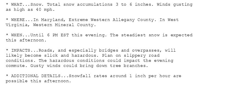
* WHAT...Snow. Total snow accumulations 3 to 6 inches. Winds gusting
as high as 40 mph.
* WHERE...In Maryland, Extreme Western Allegany County. In West
Virginia, Western Mineral County.
* WHEN...Until 6 PM EST this evening. The steadiest snow is expected
this afternoon.
* IMPACTS...Roads, and especially bridges and overpasses, will
likely become slick and hazardous. Plan on slippery road
conditions. The hazardous conditions could impact the evening
commute. Gusty winds could bring down tree branches.
* ADDITIONAL DETAILS...Snowfall rates around 1 inch per hour are
possible this afternoon.
🚨🚨🚨 Blizzard Warning issued November 22 at 9:22AM EST until November 23 at 6:00AM EST by NWS Baltimore MD/Washington DC 🚨🚨🚨
Additional Details Here.(1/2)
22.11.2024 14:30 —
👍 6
🔁 2
💬 0
📌 0
Gorgeous! Solid flake size too
21.11.2024 14:25 —
👍 3
🔁 0
💬 0
📌 0
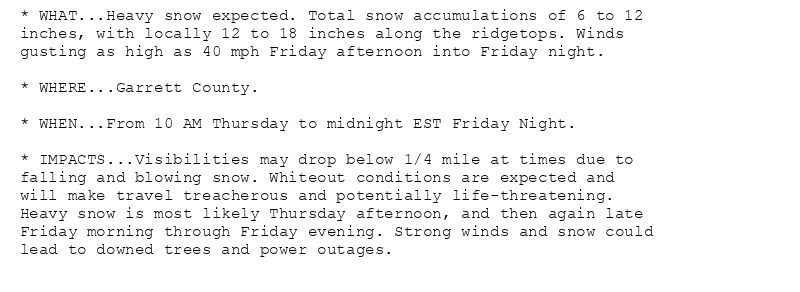
* WHAT...Heavy snow expected. Total snow accumulations of 6 to 12
inches, with locally 12 to 18 inches along the ridgetops. Winds
gusting as high as 40 mph Friday afternoon into Friday night.
* WHERE...Garrett County.
* WHEN...From 10 AM Thursday to midnight EST Friday Night.
* IMPACTS...Visibilities may drop below 1/4 mile at times due to
falling and blowing snow. Whiteout conditions are expected and
will make travel treacherous and potentially life-threatening.
Heavy snow is most likely Thursday afternoon, and then again late
Friday morning through Friday evening. Strong winds and snow could
lead to downed trees and power outages.
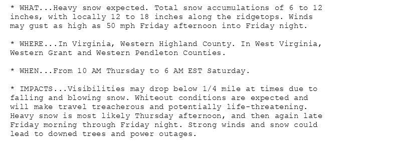
* WHAT...Heavy snow expected. Total snow accumulations of 6 to 12
inches, with locally 12 to 18 inches along the ridgetops. Winds
may gust as high as 50 mph Friday afternoon into Friday night.
* WHERE...In Virginia, Western Highland County. In West Virginia,
Western Grant and Western Pendleton Counties.
* WHEN...From 10 AM Thursday to 6 AM EST Saturday.
* IMPACTS...Visibilities may drop below 1/4 mile at times due to
falling and blowing snow. Whiteout conditions are expected and
will make travel treacherous and potentially life-threatening.
Heavy snow is most likely Thursday afternoon, and then again late
Friday morning through Friday night. Strong winds and snow could
lead to downed trees and power outages.
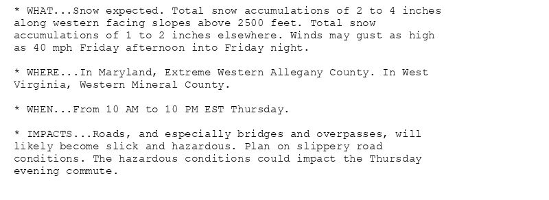
* WHAT...Snow expected. Total snow accumulations of 2 to 4 inches
along western facing slopes above 2500 feet. Total snow
accumulations of 1 to 2 inches elsewhere. Winds may gust as high
as 40 mph Friday afternoon into Friday night.
* WHERE...In Maryland, Extreme Western Allegany County. In West
Virginia, Western Mineral County.
* WHEN...From 10 AM to 10 PM EST Thursday.
* IMPACTS...Roads, and especially bridges and overpasses, will
likely become slick and hazardous. Plan on slippery road
conditions. The hazardous conditions could impact the Thursday
evening commute.
🚨 Winter Storm Warning issued November 20 at 11:24PM EST until November 23 at 12:00AM EST by NWS Baltimore MD/Washington DC 🚨
Additional Details Here.
21.11.2024 04:30 —
👍 2
🔁 1
💬 0
📌 0
I don’t think you guys know how ready I am to nerd out over this upcoming Winter Season in the Northeast on this platform.
It’s like my college days all over again!! 😍
20.11.2024 03:54 —
👍 4
🔁 0
💬 0
📌 0
And so it begins up in the Forks.
📍 Grand Forks, North Dakota moments ago #NDwx
20.11.2024 01:21 —
👍 40
🔁 4
💬 5
📌 0
However many times this was on your feed today, it wasn’t enough. Absolute perfection.
20.11.2024 00:43 —
👍 407
🔁 93
💬 5
📌 8

A headshot of me from 2023
Guess it is as good of a time as any to say this is my first week as a Senior Hurricane Specialist at NHC. Last month marked 4 years since I started at NHC & it has been an incredibly humbling yet fulfilling experience.
It is an honor to keep on doing what I love, to help save lives & property. 🌀
19.11.2024 00:27 —
👍 320
🔁 17
💬 32
📌 2
This place could use a chunky dose of delicious satellite imagery.
So here are some of my favorites I've shared over the years.
Impossible to not start with the unbeatable, the epic...
von Karman vortices
19.11.2024 02:41 —
👍 1101
🔁 245
💬 35
📌 37
Asheville taps are clear to drink; boil water notice lifted
The City of Asheville lifted the boil water notice this morning.
A major development in western North Carolina.
After a 53-day water crisis brought on by Hurricane Helene, Asheville's tap water is clear to drink.
18.11.2024 17:38 —
👍 1761
🔁 338
💬 16
📌 29
This is incredibly genius and needs to be implemented in more places. Suburbs are growing and this is the way
18.11.2024 16:24 —
👍 0
🔁 0
💬 0
📌 0
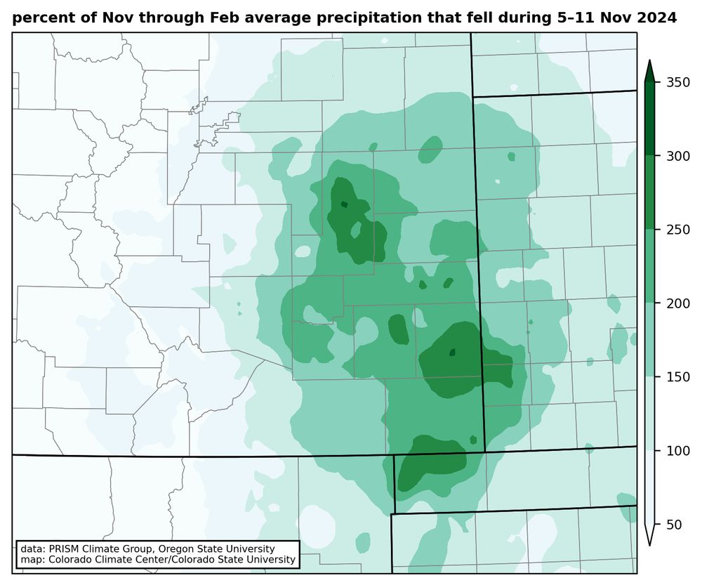
Map showing the percent of the average November through February precipitation that fell during the 5-11 November 2024 storm in southeast Colorado. Much of the region had more than twice the average amount during this single storm.
Blog recap of this month's huge snowstorm, the biggest since 1946 in much of southeastern CO. And lots of precip too: the liquid that fell from this storm was more than twice the average amount for the Nov-through-Feb period in many spots. Read on for more:
climate.colostate.edu/blog/index.p...
18.11.2024 14:47 —
👍 14
🔁 4
💬 0
📌 0
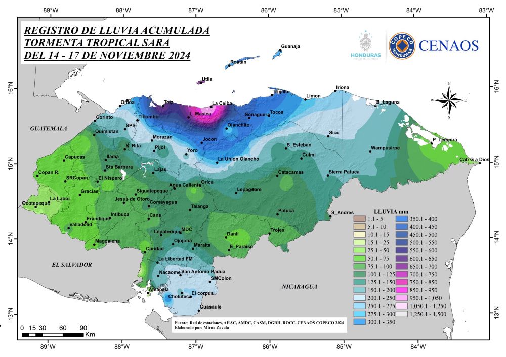
Storm total precipitation from Tropical Storm Sara in Honduras. More that 1000 millimeters (40 inches) in La Ceiba. (from COPECO)
18.11.2024 13:08 —
👍 108
🔁 52
💬 3
📌 1
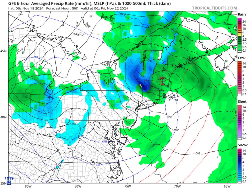
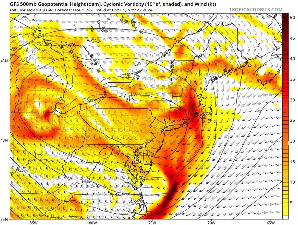
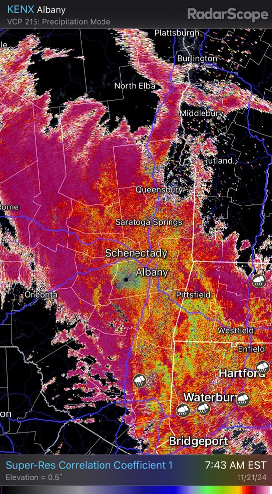
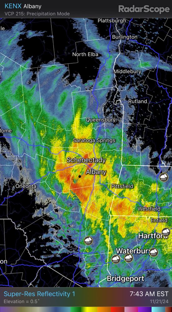
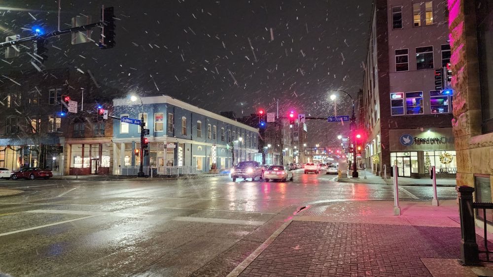
Classic setup for a pivoting band of heavy snow, first of the season, for parts of upstate #NYwx and western New England on the northern edge of a strong upper-level low.
Currently Adirondacks - southern Greens - Berkshires favored for some natural boost to early season skiing
18.11.2024 15:01 —
👍 16
🔁 1
💬 1
📌 0