It’s ***early*** and ***SSS*** obviously but have you noticed anything different with his swing mechanics so far? Any reason to at least be somewhat optimistic he can turn it around?
26.02.2026 00:36 — 👍 0 🔁 0 💬 1 📌 0It’s ***early*** and ***SSS*** obviously but have you noticed anything different with his swing mechanics so far? Any reason to at least be somewhat optimistic he can turn it around?
26.02.2026 00:36 — 👍 0 🔁 0 💬 1 📌 0Pull-side, too!
22.02.2026 18:23 — 👍 1 🔁 0 💬 1 📌 0Baseball is back!
20.02.2026 14:34 — 👍 0 🔁 0 💬 0 📌 0
🗣️NEW: In collaboration with our SPC/CIWRO
research scientists, the new Severe Hazards Data Viewer is available: spc.noaa.gov/climo/datavi.... On this webpage you can view a 30-yr record for severe storms, wildfires, and lightning in the dynamic and customizable data display.

@nws.noaa.gov Director Ken Graham presented on NOAA’s modeling grand challenge at #AMS2026 this morning. He announced that the NWS is moving to MPAS as its modeling dynamical core, with his #1 moonshot goal being a global, fully coupled 3-km Earth prediction system using MPAS.
26.01.2026 15:01 — 👍 70 🔁 25 💬 4 📌 8
Map showing temperatures in the single digits and teens across parts of Maryland, DC, and Virginia.

Map showing dew points in the single digits and teens below zero across portions of Maryland, DC, and Virginia.
Impressive Arctic air mass in place this morning. Look at those dew points! 🥶
24.01.2026 13:14 — 👍 0 🔁 0 💬 0 📌 0
A major #winterstorm is on the way for a HUGE swath of the country, with many millions of Americans in the path. Here are a few resources to prepare ahead of and stay safe during the storm: www.noaa.gov/news/dangero... @nws.noaa.gov
22.01.2026 22:06 — 👍 3 🔁 1 💬 0 📌 0It sure *feels* like this is going to drag out for a while. Crazy to think that Framber met with teams at the GM meetings almost 2 months ago!
02.01.2026 03:02 — 👍 3 🔁 0 💬 0 📌 0Now that Imai has signed, does the rest of the high-end starter market start ramping up? Personally not sure what to make of it, considering Imai’s contract is not at all what I was expecting (given all of the opt-outs). I initially figured he would help set the market, but maybe not so much.
02.01.2026 02:25 — 👍 2 🔁 0 💬 1 📌 0Happy holidays, Dan! Thanks for all of the great O’s content this year. Always appreciate your level-headed analysis. Cheers!
25.12.2025 00:08 — 👍 1 🔁 0 💬 0 📌 0Merry Torchmas! 🔥
23.12.2025 18:53 — 👍 0 🔁 0 💬 0 📌 0 28.11.2025 22:39 —
👍 1
🔁 0
💬 0
📌 0
28.11.2025 22:39 —
👍 1
🔁 0
💬 0
📌 0
Don’t tell Josh! 😁
07.11.2025 13:43 — 👍 0 🔁 0 💬 1 📌 0
WPC has initiated Key Messages for an impending coastal storm that will look to generate strong wind gusts, heavy rainfall, and significant coastal impacts that include coastal flooding, rip currents, and beach erosion along portions of the East Coast over the upcoming weekend.
08.10.2025 18:13 — 👍 85 🔁 21 💬 1 📌 4
Global Ensemble Forecast System mean precipitable water and 700-mb winds valid on Saturday morning, 11 October 2025. A big plume of moisture will be transported into the southwest US ahead of decaying Hurricane Priscilla. From https://schumacher.atmos.colostate.edu/weather/ens.php

Standardized anomaly of precipitable water from the ECWMF ensemble mean on Saturday morning, 11 October 2025. It shows a broad swath of greater than +3 standard deviations in the western US. From https://schumacher.atmos.colostate.edu/weather/ecmwf.php

Ensemble forecast plume showing precipitable water at Grand Junction, Colorado in the members of the ECWMF ensemble. Values are predicted to be around 25-30 mm with high confidence on Friday 10 October through Saturday 11 October, far above the 90th percentile for the date. From https://schumacher.atmos.colostate.edu/weather/ecmwf.php
Highly unusual situation approaching western Colorado with the moisture from Hurricane Priscilla. Grand Junction has never had precipitable water over an inch (25mm) so late in the year, but looks like it will be near that level on both Fri & Sat. Six standard deviations above average! #cowx 1/2
08.10.2025 14:23 — 👍 63 🔁 24 💬 4 📌 1Straight into my veins.
06.09.2025 12:37 — 👍 1 🔁 0 💬 0 📌 0What if morale is improving because of our August cold air damming? 😁
21.08.2025 21:27 — 👍 2 🔁 0 💬 1 📌 0
2.39” in the gauge from this evening’s downpour. #MDwx
20.07.2025 00:33 — 👍 1 🔁 0 💬 0 📌 0


Think it’s been especially humid in the DMV lately? You’d be right. Avg dew point (computed by averaging daily max/min dew point) at the three major climate sites (BWI/DCA/IAD) for July 2025 thru today all top 2 on record, and BWI is #1. Yuck. Made via mesonet.agron.iastate.edu/plotting/auto/ # 140
17.07.2025 23:36 — 👍 1 🔁 0 💬 0 📌 0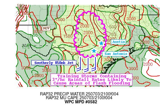
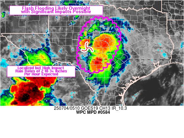
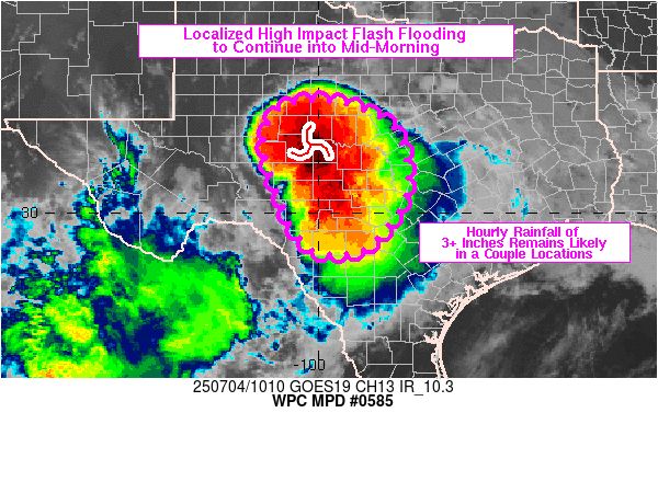
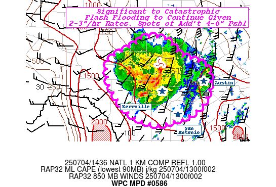
WPC issued as many as six MPDs for the deadly flash flooding in the TX Hill Country starting yesterday evening and lasting through much of today. The first MPD generally set the stage for what was to come, while the next three shown were as the event unfolded.
05.07.2025 00:03 — 👍 436 🔁 136 💬 5 📌 43
69 degree dew point this morning. #nice
16.05.2025 13:34 — 👍 1 🔁 0 💬 0 📌 0
NOAA Weather Prediction Center Excessive Rainfall Outlooks all valid for 2-3 April 2025. The outlooks were very consistent in their location and the observed flooding occurred essentially right in the locations where the outlooks showed the highest probabilities.

NOAA Weather Prediction Center Excessive Rainfall Outlooks all valid for 3-4 April 2025. The outlooks were very consistent in their location and the observed flooding occurred essentially right in the locations where the outlooks showed the highest probabilities.

NOAA Weather Prediction Center Excessive Rainfall Outlooks all valid for 4-5 April 2025. The outlooks were very consistent in their location and the observed flooding occurred essentially right in the locations where the outlooks showed the highest probabilities.

NOAA Weather Prediction Center Excessive Rainfall Outlooks all valid for 5-6 April 2025. The outlooks were very consistent in their location and the observed flooding occurred essentially right in the locations where the outlooks showed the highest probabilities.
We often (rightly) see maps like these showing how good SPC convective outlooks are; let's also give some kudos to WPC for some outstanding excessive rainfall outlooks for this event. Especially impressive are the day 5 outlooks, giving advance notice of prolonged excessive rainfall and flood risk.
06.04.2025 22:00 — 👍 92 🔁 30 💬 1 📌 0