Our updated Sea Level Rise Policy Guidance promotes equitable access to the coast for all. To learn about the Coastal Commission’s recommendations to address sea level rise impacts visit: coastal.ca.gov/climate/slr/
#EspaciosAlAireLibreParaTodos #OutdoorsForAll #environmentaljustice #coastforall
01.10.2025 20:10 — 👍 1 🔁 0 💬 0 📌 0
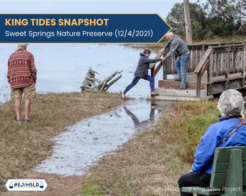
As sea levels rise, moments like this may become more common and limit access to nature, especially for people with mobility issues.
#EJinSLR #CaliforniaCoastalCommission #coastforall #coastalaccess
01.10.2025 20:10 — 👍 0 🔁 0 💬 1 📌 0

A photo of pedestrians at Sweet Springs Nature Preserve navigating pedestrian walkways after flooding from a King Tide Event. On the top left part of the slide, text in a banner reads: “King Tides Snapshot: Sweet Springs Nature Preserve (12/4/2021)”. On the bottom right of the slide, text reads: “Photo: The King Tides Project”. Hashtag logo #EJinSLR.
A King Tide briefly flooded a trail in Los Osos’ Sweet Springs Nature Preserve in December 2021.
(🧵)
#californiakingtides #californiakingtidesproject #kingtides
01.10.2025 20:10 — 👍 0 🔁 1 💬 1 📌 0
California Coastal Commission
The Coastal Commission’s updated Sea Level Rise Policy Guidance calls for planning that protects public spaces and the people who rely on them.
Learn more: coastal.ca.gov/climate/slr/
17.09.2025 16:46 — 👍 1 🔁 0 💬 0 📌 0
Extreme tides like this preview how sea level rise could intensify flooding and threaten coastal infrastructure.
#EJinSLR #CaliforniaCoastalCommission #coastforall #californiacoast #EspaciosAlAireLibreParaTodos #OutdoorsForAll #environmentaljustice
#kingtides #californiakingtides
17.09.2025 16:46 — 👍 0 🔁 0 💬 1 📌 0

A photo of waves from a King Tide high tide event crashing into the Pacifica Municipal Pier. On the top left part of the slide, text in a banner reads: “King Tides Snapshot: Pacifica Municipal Pier (1/4/2022)”. On the bottom right of the slide, text reads: “Photo: The King Tides Project”. Hashtag logo #EJinSLR
Waves crash over Pacifica’s pier during a January 2022 King Tide.
17.09.2025 16:46 — 👍 3 🔁 1 💬 1 📌 0
California Coastal Commission
Learn more: coastal.ca.gov/climate/slr/
#EJinSLR #CaliforniaCoastalCommission #coastforall #californiacoast #EspaciosAlAireLibreParaTodos #OutdoorsForAll #environmentaljustice
27.08.2025 17:45 — 👍 0 🔁 0 💬 0 📌 0

A photo of a kayaker floating over a flooded part of Bothin Marsh, close to a road. On the top left part of the slide, text in a banner reads: “King Tides Snapshot: Bothin Marsh (2/10/2024)”. On the bottom right of the slide, text reads: “Photo: The King Tides Project”. Hashtag logo #EJinSLR
This bike path at Bothin Marsh was briefly submerged during last February’s King Tides, offering a glimpse of future sea level rise impacts.
The Coastal Commission’s updated Sea Level Rise Policy Guidance provides equitable, long-term solutions to keep public spaces safe and accessible for all.
27.08.2025 17:45 — 👍 6 🔁 1 💬 1 📌 0

A photo of waves from a King Tide event washing over ripraf and flooding a pedestrian walkway at Torrey Pines State Beach in San Diego, California. On the top left part of the slide, text in a banner reads: “King Tides Snapshot: Torrey Pines State Beach (1/2/2022).” On the bottom right part of the slide, text reads “Photo: The King Tides Project”. Hashtag logo #EJinSLR.
At Torrey Pines State Beach, King Tides flood a walkway and preview how rising sea levels could threaten California. These impacts could affect public access, infrastructure, and safety.
20.08.2025 18:02 — 👍 4 🔁 4 💬 1 📌 0
Thank you for helping to photograph our highest tides, creating a record of changes to our coast and estuaries.
#californiakingtides #californiakingtidesproject #kingtides #californiacoastalcommission #sealevelrise #EJinSLR #coastalplanning #coastalinfrastructure
21.07.2025 21:50 — 👍 0 🔁 0 💬 1 📌 0
Plus, we will collect photos on Nov 6 and Dec 6, 2025 in Southern CA and some Northern CA locations.
21.07.2025 21:50 — 👍 0 🔁 0 💬 1 📌 0

A high tide spills through electrical poles onto a large flat beach that is texturized by tire tracks. The masts from a harbor and a lifeguard stand in the distance.
Hello Kingtiders! We know you’re having a busy summer, but wanted to get you the next California King Tides dates to put on your calendars.
Dec 4 & 5, 2025 and
Jan 2 & 3, 2026
(🧵)
21.07.2025 21:50 — 👍 5 🔁 1 💬 1 📌 0
Accelerating global sea level rise (1900-2024)
07.03.2025 15:50 — 👍 48 🔁 22 💬 2 📌 1

Photo of Moss Landing Sunrise by Mark Bickerstaff. A vibrant sunset over dunes and a sandy beach, with the bright orange light of the setting sun over the curve of the bay, blending into pink and purple clouds above.
During their March meeting, the Coastal Commission approved a $938,960 local assistance grant for Monterey County to update its Moss Landing Community plan and Monterey County Coastal Implementation Plan to address sea level rise and coastal hazards. Details: documents.coastal.ca.gov/reports/2025...
19.03.2025 00:23 — 👍 10 🔁 3 💬 0 📌 0
Join @airresources.bsky.social for a public meeting on California’s Climate Action Plan, March 19, in person in San Francisco. Help inform major elements of California’s Comprehensive Climate Action Plan. 5pm at 375 Beale Street. Register: forms.office.com/Pages/Respon...
08.03.2025 01:11 — 👍 1 🔁 0 💬 0 📌 0

10 tips for bringing climate change solutions into the classroom
I joined Teach For America right out of undergraduate and taught 8th-12th grade science at North Central High School in South Louisiana.
A lot of educators ask us how they can incorporate ideas about climate change in the classroom.
Here are some great ideas from Dr. Elizabeth Bagley, our Managing Director at Project Drawdown @projectdrawdown.bsky.social
drawdown.org/insights/10-...
12.02.2025 15:31 — 👍 65 🔁 22 💬 3 📌 4

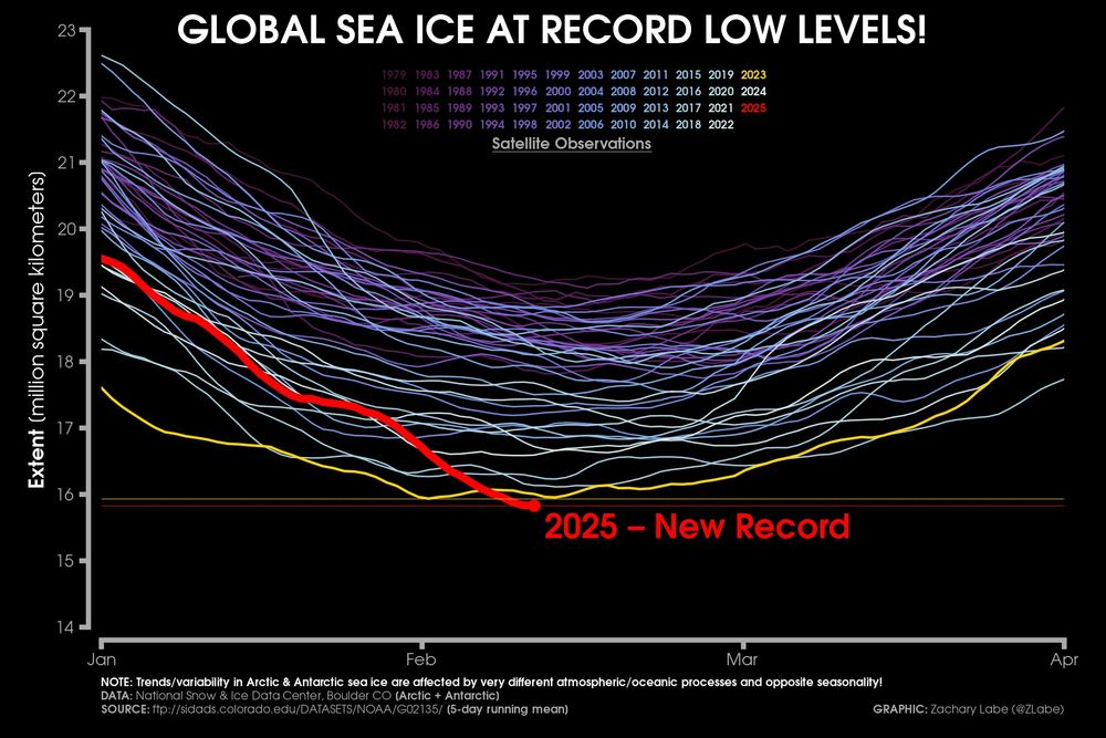
Line graph time series of 2025's daily global sea ice extent in red shading compared to each year from 1979 to 2024 using shades of purple to white for each line for between the months of January and April. The year 2023 is also highlighted in yellow, which was the current absolute record low previously. There is substantial interannual and daily variability.
A closer look at the extent of sea ice globally that just set a new all-time record minimum, which is due to unusually low sea ice conditions in both the #Arctic & #Antarctic right now.
Data from nsidc.org/data/seaice_... 🧪⚒️🥼❄️
12.02.2025 13:15 — 👍 319 🔁 150 💬 7 📌 9

A painting in front of the marsh.

An impressionistic painting of a full marsh and colorful sky

A watercolor painting of the marsh with a duck swimming by
On December 14, @sdbirdalliance.bsky.social and @ucsandiego.bsky.social Natural Reserve System led people in plein-air painting of Kendall-Frost Marsh during the #KingTides. It was a beautiful day, captured by some talented painters.
07.02.2025 16:49 — 👍 5 🔁 1 💬 0 📌 0

Is climate talk off-limits over the holidays?
The most important thing you can do to fight climate change + practical tips to help you start today
Skipping climate conversations during the holidays may seem safer—but think again. Talking about climate change doesn’t have to be overwhelming or divisive. I’m convinced it really is possible to navigate these convos in a way that brings people together, not pushes them apart. Here's how! ⬇️
28.12.2024 16:37 — 👍 270 🔁 66 💬 17 📌 6
King tide on Petaluma River (actually a tidal slough) 12/14/24. 8.1 feet plus run off.
17.12.2024 00:47 — 👍 7 🔁 1 💬 0 📌 0

West Cliff Santa Cruz , Sat Dec 14, KING high tide
18.12.2024 20:42 — 👍 3 🔁 1 💬 0 📌 0

An aerial view of the coast. A highway curves between a lagoon and the shoreline. A wave floods a beach parking lot.
Thank you to everyone who uploaded #KingTides photos! We're still working on posting them all, but you can see the results at arcg.is/0Gy5Cq. Next assignment: Have a conversation with a friend about climate change impacts on our coast and how we must take action to reduce sea level rise. 🌎🌊📷
17.12.2024 20:17 — 👍 6 🔁 2 💬 0 📌 0
King Salmon is a unique fishing community lined with canals on Humboldt Bay. This past weekend, a surge of seawater propelled by a powerful storm system, southerly winds and a king tide pushed into Avishai Leibson’s seaside falafel hut, bringing nearly a foot of water into the restaurant.
16.12.2024 22:11 — 👍 12 🔁 5 💬 1 📌 0
Climate scientist at the National Centre for Atmospheric Science, University of Reading | IPCC AR6 Lead Author | MBE | Views own | https://edhawkins.org
Warming Stripes: http://www.ShowYourStripes.info
Tinker, touch, test, experiment, notice, and play with 700+ interactive science exhibits.
https://linkin.bio/exploratorium
The California Air Resources Board is the state's lead agency in the fight against #AirPollution & #ClimateChange
arb.ca.gov
UCSC FONR hosts rare flora, fauna, and habitats in Marina, Ca. These lands are set aside for research, teaching, and public service. Part of the University of California Natural Reserve System.
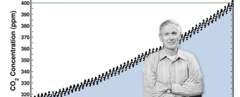
Official daily update on atmospheric CO2 levels in the post-400 ppm era from Scripps Institution of Oceanography's iconic Keeling Curve.
Coastal science serving California: Research, education and outreach. Based at @scrippsocean.bsky.social, @ucsandiego.bsky.social.
Audubon protects birds and the places they need, today and tomorrow.
For birds, for people, for the planet!
We protect, restore, and improve the health of the San Francisco Estuary.
Learn more about our work: https://t.co/hEgntuDnZf
Stay connected: https://www.sfestuary.org/connect-with-us/
Editor, writer, forever a newspaperman. Previously at Water Education Foundation, The Fresno Bee, Riverside Press-Enterprise, and a few other California stops.
Science Writer, Coast-Lover, Urbanite, Hawkwatcher, plus Managing Editor KneeDeep Times, a climate resilience magazine, and co-author A Natural History of San Francisco Bay, UC Press.
Deep-sea ecologist investigating how humans shape and reshape the sea floor. Conservation technologist developing open-source tools to understand our changing oceans. Ocean educator creating novel programs to help students interact with marine ecosystems.
(she/her) Climate change adaptation researcher + Resilience Analyst at the CPUC, Sacramento. Opinions are my own. 🏳️🌈
http://pacificadaptation.blogspot.com
The Union of Concerned Scientists puts rigorous, independent science to work to solve our planet's most pressing problems.
ucs.org
🌊 Protecting Our Ocean, Waves, and Beaches Since 1984
🤝 The Ocean Needs More Friends
🌎 Click Below to Join the Movement! ⤵
https://www.surfrider.org/join
Official account of Latino Outdoors. Connecting communities and culture with nature and conservation since 2013! #VamosOutdoors
Learn more at latinooutdoors.org
We conduct research on public climate change knowledge, attitudes, policy support & behavior. Posted events are not endorsements.
https://climatecommunication.yale.edu/


