IND issues Area Forecast Discussion (AFD) at Aug 5, 9:38 AM EDT
at Tue, 05 Aug 2025 13:39:08 +0000 via IEMbot
Additional Details Here.
05.08.2025 13:47 — 👍 0 🔁 0 💬 0 📌 0
IND issues Flood Advisory for Decatur, Rush, Shelby [IN] till Aug 5, 9:30 AM EDT
at Tue, 05 Aug 2025 10:30:05 +0000 via IEMbot
Additional Details Here.
05.08.2025 10:47 — 👍 0 🔁 0 💬 0 📌 0
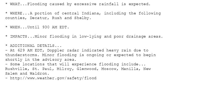
* WHAT...Flooding caused by excessive rainfall is expected.
* WHERE...A portion of central Indiana, including the following
counties, Decatur, Rush and Shelby.
* WHEN...Until 930 AM EDT.
* IMPACTS...Minor flooding in low-lying and poor drainage areas.
* ADDITIONAL DETAILS...
- At 629 AM EDT, Doppler radar indicated heavy rain due to
thunderstorms. Minor flooding is ongoing or expected to begin
shortly in the advisory area.
- Some locations that will experience flooding include...
Rushville, St. Paul, Milroy, Glenwood, Moscow, Manilla, New
Salem and Waldron.
- http://www.weather.gov/safety/flood
Flood Advisory issued August 5 at 6:29AM EDT until August 5 at 9:30AM EDT by NWS Indianapolis IN
Additional Details Here.
05.08.2025 10:45 — 👍 0 🔁 0 💬 0 📌 0
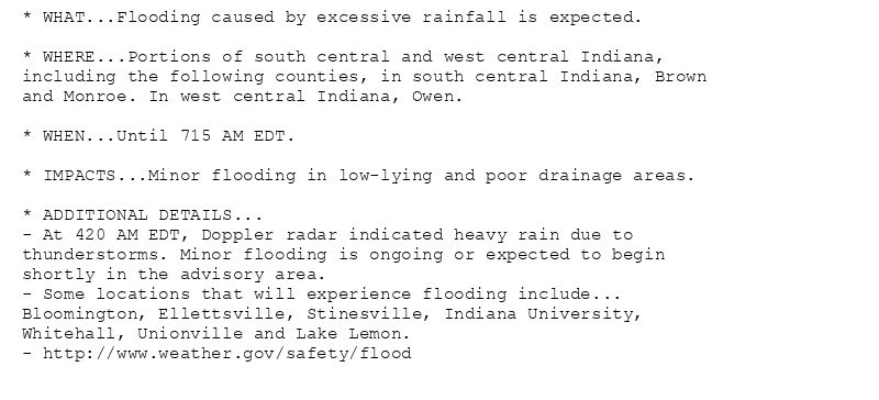
* WHAT...Flooding caused by excessive rainfall is expected.
* WHERE...Portions of south central and west central Indiana,
including the following counties, in south central Indiana, Brown
and Monroe. In west central Indiana, Owen.
* WHEN...Until 715 AM EDT.
* IMPACTS...Minor flooding in low-lying and poor drainage areas.
* ADDITIONAL DETAILS...
- At 420 AM EDT, Doppler radar indicated heavy rain due to
thunderstorms. Minor flooding is ongoing or expected to begin
shortly in the advisory area.
- Some locations that will experience flooding include...
Bloomington, Ellettsville, Stinesville, Indiana University,
Whitehall, Unionville and Lake Lemon.
- http://www.weather.gov/safety/flood
Flood Advisory issued August 5 at 4:20AM EDT until August 5 at 7:15AM EDT by NWS Indianapolis IN
Additional Details Here.
05.08.2025 08:30 — 👍 0 🔁 0 💬 0 📌 0
IND issues Flood Advisory for Brown, Monroe, Owen [IN] till Aug 5, 7:15 AM EDT
at Tue, 05 Aug 2025 08:20:48 +0000 via IEMbot
Additional Details Here.
05.08.2025 08:27 — 👍 0 🔁 0 💬 0 📌 0
IND issues Hazardous Weather Outlook (HWO) at Aug 5, 3:44 AM EDT
at Tue, 05 Aug 2025 07:46:07 +0000 via IEMbot
Additional Details Here.
05.08.2025 07:47 — 👍 0 🔁 0 💬 0 📌 0
IND issues Area Forecast Discussion (AFD) at Aug 5, 3:00 AM EDT
at Tue, 05 Aug 2025 07:01:09 +0000 via IEMbot
Additional Details Here.
05.08.2025 07:07 — 👍 0 🔁 0 💬 0 📌 0
IND issues Area Forecast Discussion (AFD) at Aug 5, 1:33 AM EDT
at Tue, 05 Aug 2025 05:34:32 +0000 via IEMbot
Additional Details Here.
05.08.2025 05:47 — 👍 0 🔁 0 💬 0 📌 0
TERRE HAUTE IN Aug 4
Climate Report:
High: 70
Low: 64
Precip: 0.65"
Snow: Missing
at Tue, 05 Aug 2025 05:39:35 +0000 via IEMbot
Additional Details Here.
05.08.2025 05:47 — 👍 0 🔁 0 💬 0 📌 0
LAFAYETTE IN Aug 4
Climate Report:
High: 82
Low: 63
Precip: 0.0"
Snow: Missing
at Tue, 05 Aug 2025 05:39:36 +0000 via IEMbot
Additional Details Here.
05.08.2025 05:47 — 👍 0 🔁 0 💬 0 📌 0
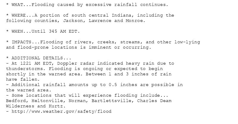
* WHAT...Flooding caused by excessive rainfall continues.
* WHERE...A portion of south central Indiana, including the
following counties, Jackson, Lawrence and Monroe.
* WHEN...Until 345 AM EDT.
* IMPACTS...Flooding of rivers, creeks, streams, and other low-lying
and flood-prone locations is imminent or occurring.
* ADDITIONAL DETAILS...
- At 1221 AM EDT, Doppler radar indicated heavy rain due to
thunderstorms. Flooding is ongoing or expected to begin
shortly in the warned area. Between 1 and 3 inches of rain
have fallen.
- Additional rainfall amounts up to 0.5 inches are possible in
the warned area.
- Some locations that will experience flooding include...
Bedford, Heltonville, Norman, Bartlettsville, Charles Deam
Wilderness and Kurtz.
- http://www.weather.gov/safety/flood
🚨 Flood Warning issued August 5 at 12:21AM EDT until August 5 at 3:45AM EDT by NWS Indianapolis IN 🚨
Additional Details Here.
05.08.2025 04:30 — 👍 0 🔁 0 💬 0 📌 0
IND extends time of Flood Warning for Jackson, Lawrence, Monroe [IN] till Aug 5, 3:45 AM EDT
at Tue, 05 Aug 2025 04:21:38 +0000 via IEMbot
Additional Details Here.
05.08.2025 04:27 — 👍 0 🔁 0 💬 0 📌 0
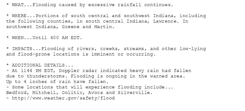
* WHAT...Flooding caused by excessive rainfall continues.
* WHERE...Portions of south central and southwest Indiana, including
the following counties, in south central Indiana, Lawrence. In
southwest Indiana, Greene and Martin.
* WHEN...Until 400 AM EDT.
* IMPACTS...Flooding of rivers, creeks, streams, and other low-lying
and flood-prone locations is imminent or occurring.
* ADDITIONAL DETAILS...
- At 1144 PM EDT, Doppler radar indicated heavy rain had fallen
due to thunderstorms. Flooding is ongoing in the warned area.
Up to 4 inches of rain have fallen.
- Some locations that will experience flooding include...
Bedford, Mitchell, Oolitic, Avoca and Silverville.
- http://www.weather.gov/safety/flood
🚨 Flood Warning issued August 4 at 11:45PM EDT until August 5 at 4:00AM EDT by NWS Indianapolis IN 🚨
Additional Details Here.
05.08.2025 04:00 — 👍 0 🔁 0 💬 0 📌 0
IND extends time of Flood Warning for Greene, Lawrence, Martin [IN] till Aug 5, 4:00 AM EDT
at Tue, 05 Aug 2025 03:46:17 +0000 via IEMbot
Additional Details Here.
05.08.2025 03:47 — 👍 0 🔁 0 💬 0 📌 0
Avoca [Lawrence Co, IN] Amateur Radio reports Flash Flood at 4 Aug, 10:15 PM EDT -- State Road 54 flooded.
at Tue, 05 Aug 2025 02:52:56 +0000 via IEMbot
Additional Details Here.
05.08.2025 03:07 — 👍 0 🔁 0 💬 0 📌 0
IND issues Flood Warning for Jackson, Lawrence, Monroe [IN] till Aug 5, 1:15 AM EDT
at Tue, 05 Aug 2025 02:08:51 +0000 via IEMbot
Additional Details Here.
05.08.2025 02:27 — 👍 0 🔁 0 💬 0 📌 0
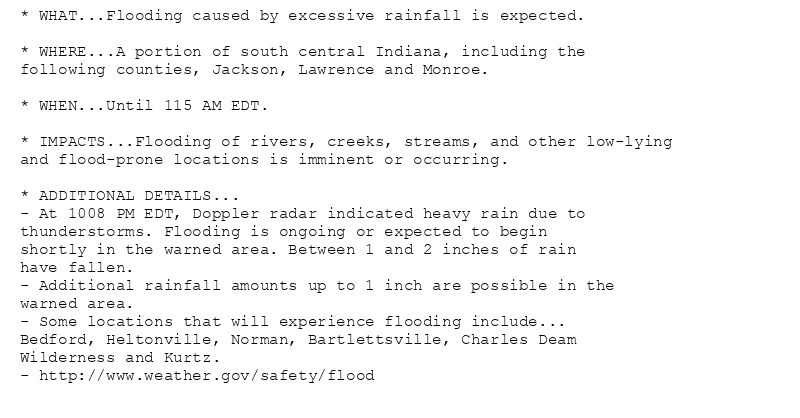
* WHAT...Flooding caused by excessive rainfall is expected.
* WHERE...A portion of south central Indiana, including the
following counties, Jackson, Lawrence and Monroe.
* WHEN...Until 115 AM EDT.
* IMPACTS...Flooding of rivers, creeks, streams, and other low-lying
and flood-prone locations is imminent or occurring.
* ADDITIONAL DETAILS...
- At 1008 PM EDT, Doppler radar indicated heavy rain due to
thunderstorms. Flooding is ongoing or expected to begin
shortly in the warned area. Between 1 and 2 inches of rain
have fallen.
- Additional rainfall amounts up to 1 inch are possible in the
warned area.
- Some locations that will experience flooding include...
Bedford, Heltonville, Norman, Bartlettsville, Charles Deam
Wilderness and Kurtz.
- http://www.weather.gov/safety/flood
🚨 Flood Warning issued August 4 at 10:08PM EDT until August 5 at 1:15AM EDT by NWS Indianapolis IN 🚨
Additional Details Here.
05.08.2025 02:15 — 👍 0 🔁 0 💬 0 📌 0
IND extends time of Flood Warning for Daviess, Knox, Martin [IN] till Aug 5, 4:00 AM EDT
at Tue, 05 Aug 2025 01:48:52 +0000 via IEMbot
Additional Details Here.
05.08.2025 02:07 — 👍 0 🔁 0 💬 0 📌 0
IND extends time of Flood Warning for Daviess, Lawrence, Martin [IN] till Aug 5, 4:00 AM EDT
at Tue, 05 Aug 2025 01:50:42 +0000 via IEMbot
Additional Details Here.
05.08.2025 02:07 — 👍 0 🔁 0 💬 0 📌 0
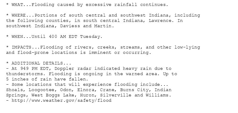
* WHAT...Flooding caused by excessive rainfall continues.
* WHERE...Portions of south central and southwest Indiana, including
the following counties, in south central Indiana, Lawrence. In
southwest Indiana, Daviess and Martin.
* WHEN...Until 400 AM EDT Tuesday.
* IMPACTS...Flooding of rivers, creeks, streams, and other low-lying
and flood-prone locations is imminent or occurring.
* ADDITIONAL DETAILS...
- At 949 PM EDT, Doppler radar indicated heavy rain due to
thunderstorms. Flooding is ongoing in the warned area. Up to
5 inches of rain have fallen.
- Some locations that will experience flooding include...
Shoals, Loogootee, Odon, Elnora, Crane, Burns City, Indian
Springs, West Boggs Lake, Huron, Silverville and Williams.
- http://www.weather.gov/safety/flood
🚨 Flood Warning issued August 4 at 9:50PM EDT until August 5 at 4:00AM EDT by NWS Indianapolis IN 🚨
Additional Details Here.
05.08.2025 02:00 — 👍 0 🔁 0 💬 0 📌 0
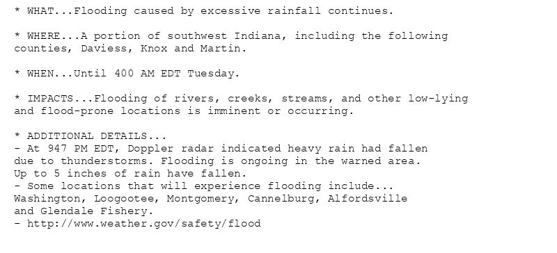
* WHAT...Flooding caused by excessive rainfall continues.
* WHERE...A portion of southwest Indiana, including the following
counties, Daviess, Knox and Martin.
* WHEN...Until 400 AM EDT Tuesday.
* IMPACTS...Flooding of rivers, creeks, streams, and other low-lying
and flood-prone locations is imminent or occurring.
* ADDITIONAL DETAILS...
- At 947 PM EDT, Doppler radar indicated heavy rain had fallen
due to thunderstorms. Flooding is ongoing in the warned area.
Up to 5 inches of rain have fallen.
- Some locations that will experience flooding include...
Washington, Loogootee, Montgomery, Cannelburg, Alfordsville
and Glendale Fishery.
- http://www.weather.gov/safety/flood
🚨 Flood Warning issued August 4 at 9:48PM EDT until August 5 at 4:00AM EDT by NWS Indianapolis IN 🚨
Additional Details Here.
05.08.2025 02:00 — 👍 0 🔁 0 💬 0 📌 0
Weather Prediction Center issues Mesoscale Precipitation Discussion #869 concerning HEAVY RAINFALL...FLASH FLOODING POSSIBLE
at Tue, 05 Aug 2025 01:43:46 +0000 via IEMbot
Additional Details Here.
05.08.2025 01:47 — 👍 0 🔁 0 💬 0 📌 0
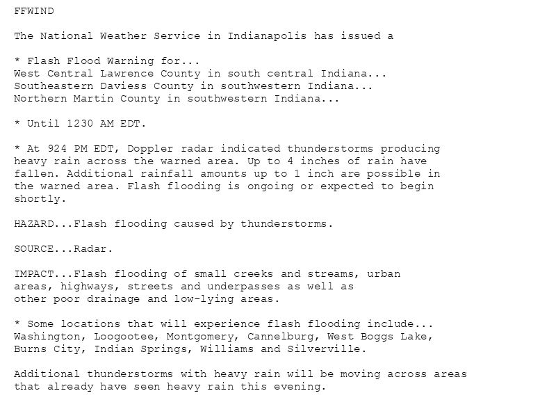
FFWIND
The National Weather Service in Indianapolis has issued a
* Flash Flood Warning for...
West Central Lawrence County in south central Indiana...
Southeastern Daviess County in southwestern Indiana...
Northern Martin County in southwestern Indiana...
* Until 1230 AM EDT.
* At 924 PM EDT, Doppler radar indicated thunderstorms producing
heavy rain across the warned area. Up to 4 inches of rain have
fallen. Additional rainfall amounts up to 1 inch are possible in
the warned area. Flash flooding is ongoing or expected to begin
shortly.
HAZARD...Flash flooding caused by thunderstorms.
SOURCE...Radar.
IMPACT...Flash flooding of small creeks and streams, urban
areas, highways, streets and underpasses as well as
other poor drainage and low-lying areas.
* Some locations that will experience flash flooding include...
Washington, Loogootee, Montgomery, Cannelburg, West Boggs Lake,
Burns City, Indian Springs, Williams and Silverville.
Additional thunderstorms with heavy rain will be moving across areas
that already have seen heavy rain this evening.
🚨 Flash Flood Warning issued August 4 at 9:24PM EDT until August 5 at 12:30AM EDT by NWS Indianapolis IN 🚨
Additional Details Here.
05.08.2025 01:30 — 👍 0 🔁 0 💬 0 📌 0
IND issues Flash Flood Warning [flash flood: radar indicated] for Daviess, Lawrence, Martin [IN] till Aug 5, 12:30 AM EDT
at Tue, 05 Aug 2025 01:24:44 +0000 via IEMbot
Additional Details Here.
05.08.2025 01:27 — 👍 0 🔁 0 💬 0 📌 0
IND issues Flash Flood Warning [flash flood: radar indicated] for Lawrence [IN] till Aug 5, 12:00 AM EDT
at Tue, 05 Aug 2025 00:57:29 +0000 via IEMbot
Additional Details Here.
05.08.2025 01:07 — 👍 0 🔁 0 💬 0 📌 0
FFWIND
The National Weather Service in Indianapolis has issued a
* Flash Flood Warning for...
Northwestern Lawrence County in south central Indiana...
* Until midnight EDT tonight.
* At 857 PM EDT, Doppler radar indicated thunderstorms producing
heavy rain across the warned area. Up to 3 inches of rain have
fallen. Additional rainfall amounts up to 2 inches are possible in
the warned area. Flash flooding is ongoing or expected to begin
shortly.
HAZARD...Flash flooding caused by thunderstorms.
SOURCE...Radar.
IMPACT...Flash flooding of small creeks and streams, urban
areas, highways, streets and underpasses as well as
other poor drainage and low-lying areas.
* Some locations that will experience flash flooding include...
Bedford, Oolitic and Avoca.
🚨 Flash Flood Warning issued August 4 at 8:57PM EDT until August 5 at 12:00AM EDT by NWS Indianapolis IN 🚨
Additional Details Here.
05.08.2025 01:00 — 👍 0 🔁 0 💬 0 📌 0
IND issues Flood Warning for Greene, Lawrence, Martin [IN] till Aug 5, 12:00 AM EDT
at Tue, 05 Aug 2025 00:28:14 +0000 via IEMbot
Additional Details Here.
05.08.2025 00:47 — 👍 0 🔁 0 💬 0 📌 0
* WHAT...Flooding caused by excessive rainfall is expected.
* WHERE...Portions of south central and southwest Indiana, including
the following counties, in south central Indiana, Lawrence. In
southwest Indiana, Greene and Martin.
* WHEN...Until midnight EDT tonight.
* IMPACTS...Flooding of rivers, creeks, streams, and other low-lying
and flood-prone locations is imminent or occurring.
* ADDITIONAL DETAILS...
- At 827 PM EDT, Doppler radar indicated heavy rain due to
thunderstorms. Flooding is ongoing or expected to begin
shortly in the warned area. Up to 2 inches of rain have
fallen.
- Additional rainfall amounts up to 2 inches are possible in
the warned area.
- Some locations that will experience flooding include...
Bedford, Mitchell, Oolitic, Avoca and Silverville.
- http://www.weather.gov/safety/flood
🚨 Flood Warning issued August 4 at 8:27PM EDT until August 5 at 12:00AM EDT by NWS Indianapolis IN 🚨
Additional Details Here.
05.08.2025 00:30 — 👍 0 🔁 0 💬 0 📌 0
4 E Vincennes [Knox Co, IN] Trained Spotter reports Rain of 2.47 Inch at 4 Aug, 8:04 PM EDT -- 2 inches of rainfall between 645 and 745 pm. Total rainfall as of 8 pm is 2.47 inches... at Tue, 05 Aug 2025 00:09:32 +0000 via IEMbot
Additional Details Here.
05.08.2025 00:27 — 👍 0 🔁 0 💬 0 📌 0
Loogootee [Martin Co, IN] Public reports Flood at 7:13 PM EDT -- Street flooded.
at Mon, 04 Aug 2025 23:36:21 +0000 via IEMbot
Additional Details Here.
04.08.2025 23:47 — 👍 0 🔁 0 💬 0 📌 0