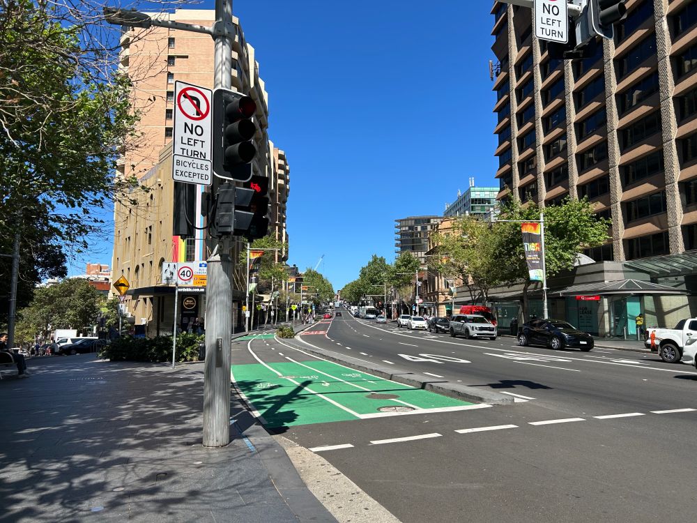
Looking along a wide road with a bidirectional cycleway on the left of the road, where the lane going towards the viewpoint splits into 2 lanes, 1 for going straight and 1 for turning right

A bidirectional cycleway next to a road, separated from the road by a kerb

A cycleway next to a road approaching an intersection with another road

A cycleway in between a footpath and a bus stop, with a zebra crossing across the cycleway to connect the footpath and the bus stop, and a fence between the bus stop and the cycleway
The Oxford Street cycleway in Sydney opened recently. This cycleway on a major road links multiple other cycleways, making the cycling network more connected.
05.10.2025 00:28 — 👍 9 🔁 0 💬 0 📌 0
YouTube video by Exploring Sydney's Railways
Exploring Wiley Park
New Exploring Sydney's Railways video! In this one, filmed in June 2024 before the closure of the Bankstown Line, I visit Wiley Park. www.youtube.com/watch?v=dTzj...
25.09.2025 11:55 — 👍 2 🔁 1 💬 0 📌 0

Looking along the side of a dock towards a rock wall in the distance, with disused railway tracks parallel to the dock and boats in the water on the left

Looking along the side of a dock towards a rock wall in the distance, with a path elevated just above the ground leading forward and a rock wall on the right with vegetation in front of it

Looking towards a rock wall at the end of a dock, which overhangs the far end of the dock and is otherwise a vertical wall curving around the walkway around the dock

Looking along a dock from its far end, with boats in the water on the right side and rock walls on the left and right sides of the dock
The Woolwich Dock in Woolwich, Sydney. It originally opened in 1901, and an expansion was completed in 1918. It was formerly a dry dock.
18.09.2025 09:28 — 👍 6 🔁 2 💬 0 📌 0
The reason these trains start/stop at Central is because they use the tracks between Central and Strathfield mainly used by intercity trains, rather than the tracks that connect with the North Shore Line.
25.08.2025 06:55 — 👍 1 🔁 0 💬 1 📌 0

Looking into a tunnel from the under-construction station box of the Parramatta metro station
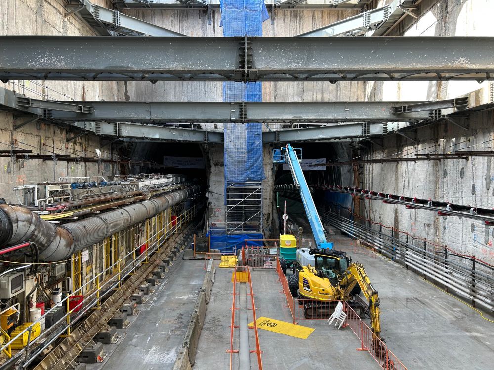
Looking towards the eastern wall of the under-construction station box for the Parramatta metro station from part of the way down, with 2 tunnels continuing past the wall and the back section of a tunnel boring machine on the left side

Looking up towards the side of the under-construction station box for the Parramatta metro station, where large metal beams support a concrete retaining wall

Inside the under-construction station box for the Parramatta metro station, looking up towards horizontal metal beams supporting the walls on either side
The other tunnel boring machine tunneling this section had already started tunneling west beyond the station. There has been a lot of progress since the previous open day, and the eastern part of the station box has reached its full depth.
16.08.2025 10:53 — 👍 1 🔁 0 💬 0 📌 0
A week ago I visited another Sydney Metro West open day at the site of the future Parramatta metro station. The main focus of this open day was seeing one of the tunnel boring machines, as it was in the station box on the day. bsky.app/profile/unsp...
16.08.2025 10:53 — 👍 2 🔁 1 💬 1 📌 0
This was also the reason for the gap between posts between May and August 2024, but I decided to return to posting because the Sydney Metro extension was about to open. After a few months I decided to return to not posting until I finished the video.
11.08.2025 11:55 — 👍 0 🔁 0 💬 0 📌 0
The reason why I haven't posted for several months before today is because I wanted my next post to be about the Riverstone video, but I kept on putting off finishing the video, so I didn't make other posts until the video was done.
11.08.2025 11:55 — 👍 0 🔁 0 💬 1 📌 0
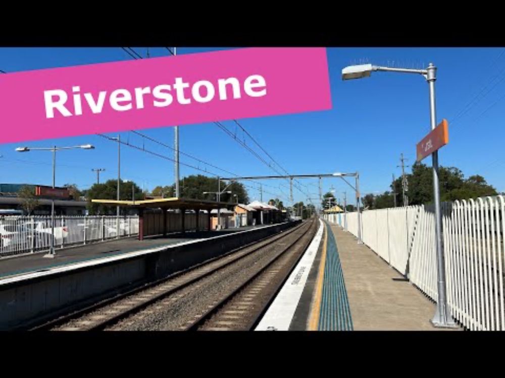
I visited this station and filmed this video in April 2024, and it took me a very long time to get around to writing and editing it. I have finally done it though, and now I aim to start releasing videos more frequently again.
11.08.2025 10:29 — 👍 1 🔁 0 💬 0 📌 0
YouTube video by Exploring Sydney's Railways
Exploring Riverstone
New Exploring Sydney's Railways video! In this one I visit Riverstone, an unusual station on the Sydney rail network as it has a level crossing next to it. www.youtube.com/watch?v=waQv...
11.08.2025 10:27 — 👍 2 🔁 1 💬 1 📌 0
It's used a few times a day when the frequency of the line is increasing or decreasing.
23.01.2025 08:39 — 👍 1 🔁 0 💬 0 📌 0
There are some other stations with errors in the platform layout, including Lidcombe, Parramatta, Lewisham, and Glenfield
10.12.2024 07:37 — 👍 1 🔁 0 💬 1 📌 0
This is really impressive! I like the way that platforms are shown.
10.12.2024 06:28 — 👍 1 🔁 0 💬 1 📌 0
I think the Eastern Suburbs Line should go there instead of this line. For this line to go to Maroubra it would have to have a sharp curve before or after Randwick.
09.12.2024 02:56 — 👍 3 🔁 0 💬 0 📌 0
It's interesting how some Sydney transit map designs fit in a portrait format, while others fit in a landscape format.
01.12.2024 05:56 — 👍 2 🔁 0 💬 1 📌 0
This is my idea for how a southeastern extension of Sydney Metro West should go, but what do you think? Are there any stations you'd place differently, or do you think the line should take a completely different route? (12/12)
30.11.2024 05:31 — 👍 1 🔁 0 💬 1 📌 0
Official vague plans show the line going further south from Randwick, but I think this would work better as an extension of the existing Eastern Suburbs Line. That line should be extended to Randwick like in its original plan, and then south towards La Perouse. (11/12)
30.11.2024 05:31 — 👍 1 🔁 0 💬 1 📌 0
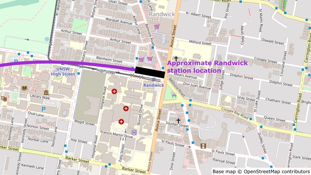
Map showing the approximate location of the Randwick station, on the north side of High Street west of Avoca Street.
The terminus of the line would be at Randwick, next to the existing light rail stop. This major center has good bus connections to other parts of the Eastern Suburbs. (10/12)
30.11.2024 05:31 — 👍 1 🔁 0 💬 1 📌 1
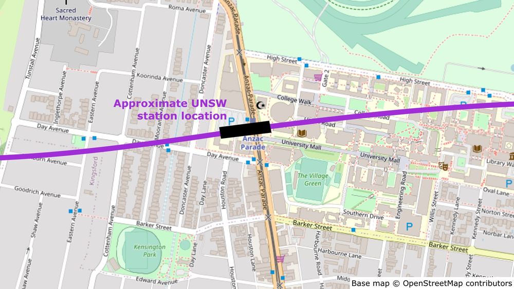
Map showing the approximate location of the UNSW station, underneath the UNSW Anzac Parade light rail stop, perpendicular to Anzac Parade.
The penultimate stop would be at the western side of the University of New South Wales, and would be an interchange with the UNSW Anzac Parade light rail stop. This would give the university a higher-capacity rail connection. (9/12)
30.11.2024 05:31 — 👍 1 🔁 0 💬 1 📌 0
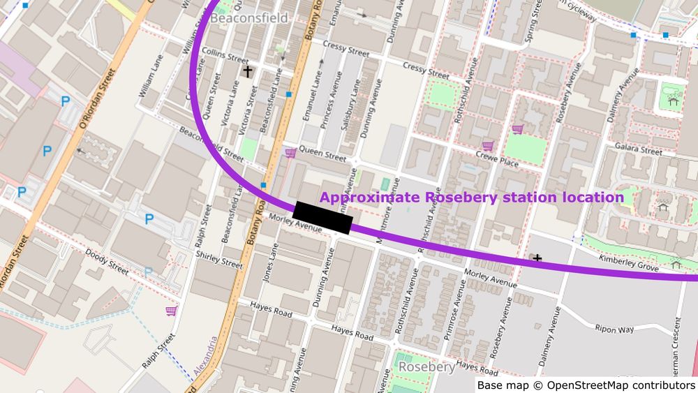
Map showing the approximate location of the Rosebery station, on the north side of Morley Avenue, crossing Dunning Avenue.
The next station would be Rosebery, on the north side of Morley Avenue. There are lots of commercial buildings in this area and more housing could be built as well. This is where the line would turn east. (8/12)
30.11.2024 05:31 — 👍 1 🔁 0 💬 1 📌 0
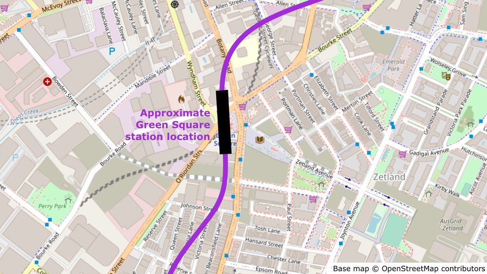
Map showing the approximate location of the Green Square station, underneath the existing Green Square station, between O'Riordan Street and Botany Road, and crossing Bourke Road.
Next would be an interchange at Green Square, letting passengers transfer between this line and the Airport Line and adding another connection to this dense area. A new island platform would be built underneath the existing side platforms at a different angle. (7/12)
30.11.2024 05:31 — 👍 1 🔁 0 💬 1 📌 0
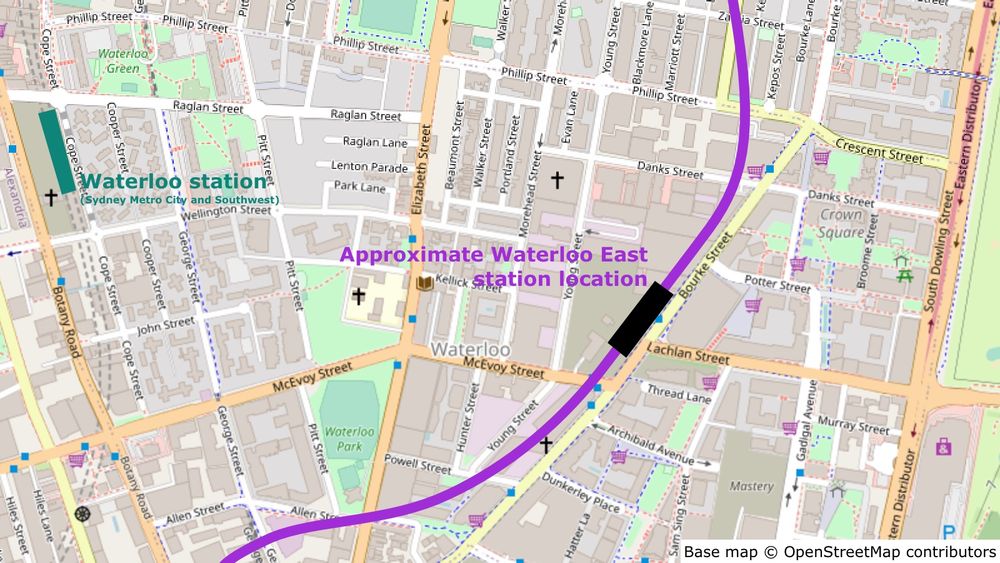
Map showing the approximate location of the Waterloo East station, on the west side of Bourke Street opposite the intersection with Lachlan Street. The location of Waterloo station on the Sydney Metro City and Southwest line is also shown.
The next station would be Waterloo East, serving the high-density housing in the area. I've put the station in the large open area here but I'm not sure if this would be possible; if it isn't, there are other places to the north where the station could go. (6/12)
30.11.2024 05:31 — 👍 1 🔁 0 💬 1 📌 0
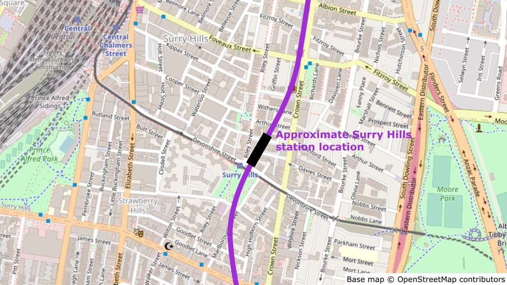
Map showing the approximate location of the Surry Hills station, on the north side of the light rail stop and east of Riley Street.
Next would be Surry Hills, at a station just north of the existing light rail stop. From here people could get a tram to Moore Park. (5/12)
30.11.2024 05:31 — 👍 1 🔁 0 💬 1 📌 0
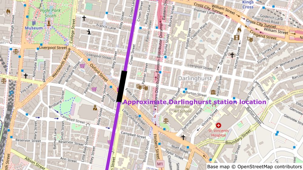
Map showing the approximate location of the Darlinghurst station, on the western side of the intersection between Crown Street and Oxford Street.
The first stop after Hunter Street would be Darlinghurst, at the intersection of Oxford Street and Crown Street. This would serve the southeastern CBD and the busy Oxford Street area. (A station further north at Woolloomooloo isn't possible due to the Cross City Tunnel.) (4/12)
30.11.2024 05:31 — 👍 1 🔁 0 💬 1 📌 0
An extension to the southeast is already planned for the Sydney Metro West line, but an official route hasn't been announced. This is my proposal for where this extension should go. (3/12)
30.11.2024 05:31 — 👍 1 🔁 0 💬 1 📌 0
(I originally posted this thread 1 year ago on Twitter. In the original version I called the extension Sydney Metro East, but in this version I've renamed it to Sydney Metro Southeast.) (2/12)
30.11.2024 05:31 — 👍 1 🔁 0 💬 1 📌 0
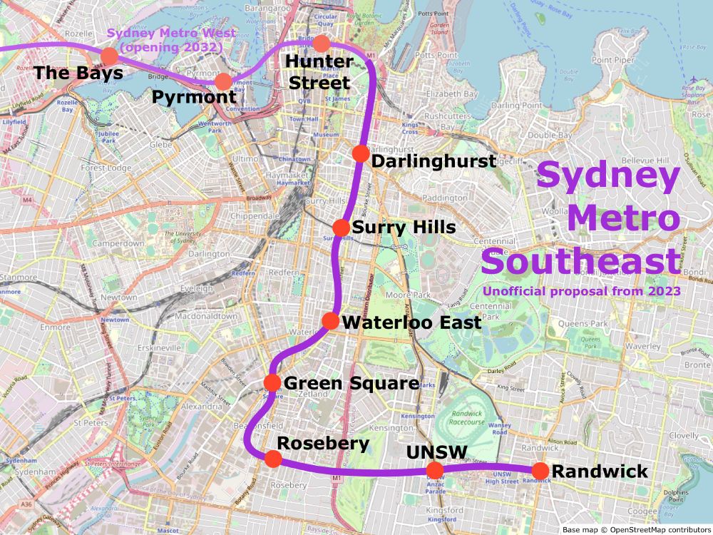
Map of my unofficial proposal for the Sydney Metro Southeast extension. After the under-construction Sydney Metro West stations of The Bays, Pyrmont, and Hunter Street, it would stop at Darlinghurst, Surry Hills, Waterloo East, Green Square, Rosebery, UNSW, and Randwick.
What's next for Sydney Metro after Sydney Metro West?
I think one of the next projects should be Sydney Metro Southeast – an extension of the line to Randwick via Green Square. (thread, 1/12)
30.11.2024 05:31 — 👍 7 🔁 2 💬 2 📌 0
This is a list of stations counted as Not Accessible or Assisted Access on the Transport for NSW website. Assisted Access includes stations where there are steep ramps or level crossings to access some platforms.
28.11.2024 02:43 — 👍 1 🔁 0 💬 1 📌 0
It has lifts to platforms 5-7, but not to platforms 2-4. It's a similar situation to Redfern, where some platforms are accessible but not all platforms.
28.11.2024 00:36 — 👍 4 🔁 0 💬 0 📌 0
Sydney stations without full accessibility: Asquith, Bardwell Park, Carramar, Chester Hill, Clarendon, Clyde, Homebush, Leightonfield, Lewisham, Loftus, Macdonaldtown, Macquarie Fields, Mount Kuring-gai, Redfern, Riverstone, Tempe, Villawood, Vineyard, Yennora.
27.11.2024 22:54 — 👍 6 🔁 0 💬 5 📌 0
sjmielke.com 🏠 Brooklyn, NY
The world-famous urban theorist who…wait, this has to be honest‽
Independent Professional Urbanist and Writer, creating in-depth critiques of urban spaces, places, & systems.
My work:
thefoxandthecity.com
Also ED @etany.org
She/her
Elections, electoral behaviour, electoral admin and Related Matters.
Based on a true story.
Dibuixant estacions 🚇🗺
albertguillaumes.cat
(she/her)
a transit nerd programmer who sometimes tries to be an artist, writer, cartographer & musician.
in singapore, unless she's in japan
enjoys trains, space, vocal synthesizers and project sekai. and also a bunch of other things
english・中文・少し日本語
train driver, computer game enjoyer & cat lover 🥰
Not actually a train. Personal account, views mine. He/they. 🏙️🚇🏳️🌈🏳️⚧️
QLDer, musician, Green, politics/elections nerd
Trains, Travel and Transit 🚂🌎🚇
Find me on Youtube: http://intercitysimon.com/
The same one you know from that other (formerly) Blue app
"Why not be bolder if the political price is likely to be the same?"
numbers gremlin.
i invented ravioli
• do NOT contact me with unsolicited services or offers
(they/them) Welcome, you've found Tara's bsky account.
I'm a Metro Trains Melbourne AU Rail Replacement Bus Driver.
When trains don't run, I replace them for you.
I'm Genderfluid non-binary and Asexual
Tarawa Day: 23-Nov-2022
X Twitter: @ im_not_tara
Trains are like dragons: massive, majestic, mystical and capable of quickly taking you on an exotic adventure.
https://linktr.ee/jrurbanenetwork
Director of Transportation, Madison, WI; Author of “Trains, Buses, People: An Opinionated Atlas of US and Canadian Transit,” Island Press, 2021. (he/him) PE/AICP/LEED AP


