MissDelta's Carol Wilson talked about the value of wetlands, as well as the Birdsfoot, relative sea level rise and delta building on a recent episode of BBC Discovery.
Hear what she had to say, starting at about the 7 minute mark: www.bbc.com/audio/play/w...
#coastalscience #environmentalscience
03.02.2026 21:27 —
👍 0
🔁 0
💬 0
📌 0

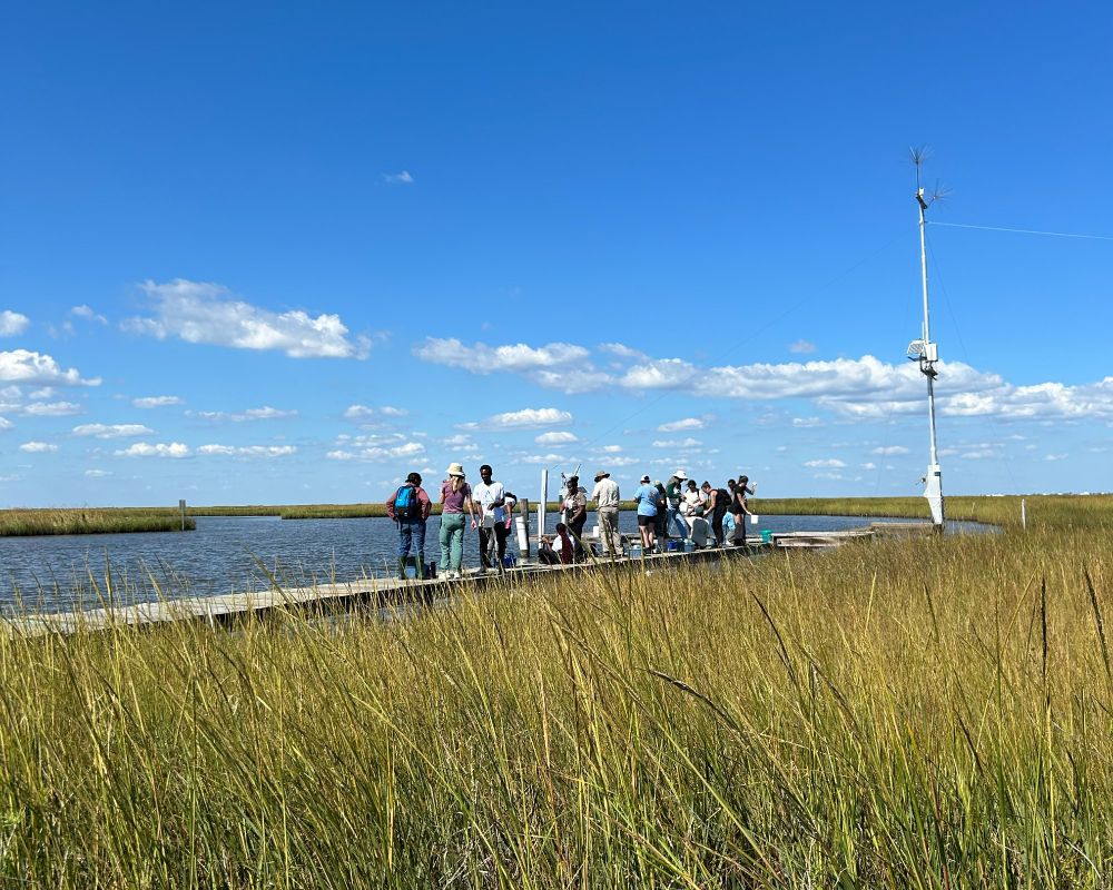
A beautiful day for some research ☀️🌊
#coastalscience #environmentalscience #missdeltainitiative
06.11.2025 18:56 —
👍 1
🔁 0
💬 0
📌 0

How would various hypoxia reduction strategies impact fisheries in the Gulf?
MissDelta's Kim de Mutsert and a team of researchers built a model to find out. Their takeaway? Slight changes in populations, big changes in distribution
https://doi.org/10.1093/mcfafs/vtaf032
#hypoxia #coastalscience
31.10.2025 14:30 —
👍 0
🔁 1
💬 0
📌 0

From conference presentations to publications, we're celebrating all the work our researchers have done over the past year to lead discussions about #coastalscience, the #mississippiriver, the Gulf and more!
23.10.2025 21:09 —
👍 1
🔁 0
💬 0
📌 0

Marshy
#blueskymonday #photography #water #marsh #nature #blue
20.10.2025 22:45 —
👍 2963
🔁 217
💬 92
📌 14

How do you gather data in a marsh?
LiDAR drone surveys – Penetrate vegetation canopy to detect subsidence, uplift, and morphological changes in the marsh substrate
Hyperspectral imagery – Capture detailed data on plant species distribution, growth patterns, and density variations
#coastalscience
21.10.2025 20:24 —
👍 1
🔁 0
💬 0
📌 0

How do you map a marsh when you can't see through murky water or dense vegetation?
MissDelta researcher Rahul Biswas tackled this challenge across three sites in the Birdsfoot Delta this summer—using some cool tech along the way.
Follow along here to learn more
#researchinaction #coastalscience
21.10.2025 19:52 —
👍 1
🔁 0
💬 0
📌 0
“My research highlights how advanced remote sensing techniques can reveal critical land deformation patterns in the Mississippi Delta and their links to vegetation dynamics under changing climatic scenarios," says Rahul.
#coastalscience #environmentalscience #mississippiriver #wetlands
17.10.2025 03:49 —
👍 2
🔁 0
💬 0
📌 0

This week's student researcher is Rahul Biswas, a graduate student at Jackson State University.
Rahul is working with Professor Sadik Khan to monitor and predict marsh subsidence and changes in vegetation.
⤵️to hear what Rahul has to say about his research.
17.10.2025 03:49 —
👍 1
🔁 0
💬 1
📌 0

Attention MissDelta researchers! You can now connect with us on LinkedIn:
www.linkedin.com/company/miss...
10.10.2025 18:42 —
👍 1
🔁 0
💬 0
📌 0
Now Mariotti and other MissDelta modelers will use the same techniques to better understand the future of the Birdsfoot
07.10.2025 21:40 —
👍 1
🔁 0
💬 0
📌 0
This model represents 2500 years of evolution of a New England marsh.
Most marsh modeling is based on short term measurements, but MissDelta's Giulio Mariotti built in factors like currents and sediment movement that allowed him to represent long term growth and changes in the marsh.
07.10.2025 21:40 —
👍 1
🔁 0
💬 1
📌 0

This October, come by and see us at one of these awesome events!
03.10.2025 00:40 —
👍 1
🔁 0
💬 0
📌 0
This research allows MissDelta to build a stronger understanding of river conditions during saltwater intrusion, including calibrating predictive numerical models, so we can help communities in the lower Mississippi River prepare for changing conditions and build a more sustainable future.
25.09.2025 21:32 —
👍 1
🔁 0
💬 0
📌 0
If the wedge progresses upstream of water intakes in Plaquemines Parish, and even the Greater New Orleans area, it can impact drinking water supplies for all communities that rely on drinking water from the Mississippi River.
25.09.2025 21:32 —
👍 1
🔁 0
💬 1
📌 0
will likely require a decision by the US Army Corps of Engineers to initiate construction of the underwater sand sill at River Mile 63.
This will mark the extraordinary 4th consecutive year the sill will be required to stop continued upstream migration of the salt wedge.
25.09.2025 21:32 —
👍 0
🔁 0
💬 1
📌 0
These observations, along with projections of falling river discharge over the next month forecast by NOAA and linked to a prolonged drought in parts of the Mississippi River Basin,
25.09.2025 21:32 —
👍 0
🔁 0
💬 1
📌 0
Researchers studied the temperature, salinity and sediment concentration of the water and the speed of the river and wedge current down the axis of the river below New Orleans. During this study the upstream toe (or tip) of the wedge was found to be around River Mile 33, below Port Sulphur.
25.09.2025 21:32 —
👍 1
🔁 0
💬 1
📌 0


MissDelta scientists hit the water last week to to map the location of the saltwater wedge encroaching up the Mississippi River.
Learn about their work ⤵️
25.09.2025 21:32 —
👍 1
🔁 0
💬 1
📌 0
Brannum says she hopes her research can help in coastal restoration. “I am most excited to use my research to guide vegetation plantings and restoration projects that leverage the benefits of vegetation to protect our coastlines.”
23.09.2025 17:44 —
👍 1
🔁 0
💬 0
📌 0
She uses an acoustic doppler current profiler to measure the speed of water flow in deeper parts of the channel.
Although the ADCP and dye measure different things, she says, they “do generally agree about the system having faster water speed through the channel compared to the platform.”
23.09.2025 17:44 —
👍 1
🔁 0
💬 1
📌 0
Brannum collects water samples to measure volume of sediment.
She tracks the flow of water on the marsh platform by putting dye in, then using drones to track the flow patterns.
23.09.2025 17:44 —
👍 0
🔁 0
💬 1
📌 0
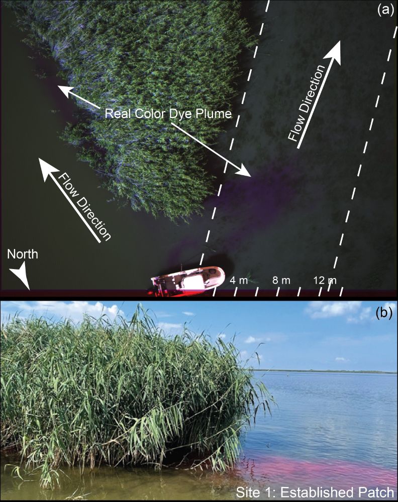

📣It’s Estuaries Week 🌱 Time to take a look at MissDelta’s work in Louisiana’s coastal marshes.
Sarah Brannum, a PhD student at LSU, wants to better understand how vegetation affects the flow of water and sediment in the marsh.
Read about her work and the methods she uses⤵️
23.09.2025 17:44 —
👍 2
🔁 0
💬 1
📌 0
 13.02.2026 21:16 —
👍 0
🔁 0
💬 0
📌 0
13.02.2026 21:16 —
👍 0
🔁 0
💬 0
📌 0