Suomi Kuvakartta Sommitellut by Aarne Nopsernen (1956)
Translation: Finland Photo Map composed by Aarne Nopsernen
![[map portion] Suomi Kuvakartta Sommitellut by Aarne Nopsernen (1956)
Translation: Finland Photo Map composed by Aarne Nopsernen
Showing natural resources, tourists and wolves.](https://cdn.bsky.app/img/feed_thumbnail/plain/did:plc:q66r3vy7xepmx62ti4vt7uzb/bafkreiftdjqmmrpussf3piknnie7gpyzmuzgbbjuakj5lqgbkhowneu3oy@jpeg)
[map portion] Suomi Kuvakartta Sommitellut by Aarne Nopsernen (1956)
Translation: Finland Photo Map composed by Aarne Nopsernen
Showing natural resources, tourists and wolves.
![[map portion] Suomi Kuvakartta Sommitellut by Aarne Nopsernen (1956)
Translation: Finland Photo Map composed by Aarne Nopsernen
Showing: Cities of Hanko, Helsinki, Kotka](https://cdn.bsky.app/img/feed_thumbnail/plain/did:plc:q66r3vy7xepmx62ti4vt7uzb/bafkreihwtv5uddapr7skyg5xkqiwos4fmh2b7qwaphezrksah6cj74jiey@jpeg)
[map portion] Suomi Kuvakartta Sommitellut by Aarne Nopsernen (1956)
Translation: Finland Photo Map composed by Aarne Nopsernen
Showing: Cities of Hanko, Helsinki, Kotka
![[map portion] Suomi Kuvakartta Sommitellut by Aarne Nopsernen (1956)
Translation: Finland Photo Map composed by Aarne Nopsernen
Showing: North West part of the country -- Länsi-Lappi](https://cdn.bsky.app/img/feed_thumbnail/plain/did:plc:q66r3vy7xepmx62ti4vt7uzb/bafkreifrubjhc3vpvqwix5pfyrel45tnt64sh6ala3oc3phty62ofgivby@jpeg)
[map portion] Suomi Kuvakartta Sommitellut by Aarne Nopsernen (1956)
Translation: Finland Photo Map composed by Aarne Nopsernen
Showing: North West part of the country -- Länsi-Lappi
Suomi Kuvakartta Sommitellut by Aarne Nopsernen (1956)
Scanned at 600dpi. This pictorial map is worth a zoom and pan archive.org/details/WCWd...
#Finland #Independence #Day
#Suomi #AarneNopsernen #PictoralMap
06.12.2025 22:17 — 👍 4 🔁 1 💬 0 📌 0

Cover of Oliver Jeffers children’s book :
Here We Are: Notes for Living on Planet Earth
Great visuals, wide range of scales and landscapes. The author is writing about where we are to their newborn …
Well, hello.
Welcome to this planet.
We call it earth.
It is the big globe,
floating in space,
on which we live.
06.12.2025 04:45 — 👍 3 🔁 0 💬 1 📌 0
![[map portion] Topographic map showing "Hold with Hope"
From the Grönland [topographic series
Scale 1:250,000
Publisher: Geodætisk Institut](https://cdn.bsky.app/img/feed_thumbnail/plain/did:plc:q66r3vy7xepmx62ti4vt7uzb/bafkreihzwb3rwk6qshvnxjje2t5vsa4ful2ix3uvstilig2j4ibtharhoa@jpeg)
[map portion] Topographic map showing "Hold with Hope"
From the Grönland [topographic series
Scale 1:250,000
Publisher: Geodætisk Institut

Legend from Topographic map showing "Hold with Hope"
From the Grönland [topographic series
Scale 1:250,000
Publisher: Geodætisk Institut
![[map portion] Topographic map showing "Spaths Plateau"
From the Grönland [topographic series
Scale 1:250,000
Publisher: Geodætisk Institut](https://cdn.bsky.app/img/feed_thumbnail/plain/did:plc:q66r3vy7xepmx62ti4vt7uzb/bafkreibnabts6utoctzplmjckbilvyl2goazua4eg3gn5nir6ipcfujvvi@jpeg)
[map portion] Topographic map showing "Spaths Plateau"
From the Grönland [topographic series
Scale 1:250,000
Publisher: Geodætisk Institut
More stunning #cartography from the Geodætisk Institut
73 Ö.1 "Hold with Hope"
#Grönland #topographic series 1:250,000
#Greenland #GeodætiskInstitut #map #diaeresis #HoldwithHope
06.12.2025 03:14 — 👍 4 🔁 0 💬 0 📌 0

A display of various William C. Wonders Map Collection atlas and map reproductions.

Table covered in donated maps that are being processed for the William C. Wonders Map Collection.
The #map table.
November - a display setting for a collection #facsimile tour. December - a working environment for processing donations. #WCWMC #MapLibrarianship
06.12.2025 00:10 — 👍 4 🔁 0 💬 0 📌 0
to help offset all the trees put in a tree museum vibe - two spatial pieces...
--Jacqueline Warwick's I Drew a Map of Canada: Joni Mitchell’s Constructions of Place. 2004 tinyurl.com/3ab6p8vv
--Jack Bishop's Mapping Joni Mitchell's 'Hejira' the refuge of the roads. 2024. tinyurl.com/3uuywsst
05.12.2025 14:08 — 👍 2 🔁 0 💬 0 📌 0

Map of Canada with a dot layer symbolizing different types of 'local solutions', organizations and initiatives working to solve complex challenges that communities are facing across Canada. Dots are coloured by different categories (e.g. housing, climate change, etc.) and clustered by province/territory.
Map we made for the School of Cities' Learning From What Works project — a major report profiling 89 amazing community projects and organizations from across Canada
Check out the report here: schoolofcities.utoronto.ca/research-pub...
05.12.2025 13:16 — 👍 4 🔁 1 💬 0 📌 0
![[map portion] showing sheet : MYGGENÆS (M 23) 1974. From the Danmark, Faeröerne 1:20,000 scale series. Publisher: Geodaetisk Institut](https://cdn.bsky.app/img/feed_thumbnail/plain/did:plc:q66r3vy7xepmx62ti4vt7uzb/bafkreibzuya5pkqyzsbohqn5e5lrdgq5s7rgjq3ovs36wr2nvlosnsahry@jpeg)
[map portion] showing sheet : MYGGENÆS (M 23) 1974. From the Danmark, Faeröerne 1:20,000 scale series. Publisher: Geodaetisk Institut
![[map portion] showing sheet : MYGGENÆS (M 23) 1974. From the Danmark, Faeröerne 1:20,000 scale series. Publisher: Geodaetisk Institut](https://cdn.bsky.app/img/feed_thumbnail/plain/did:plc:q66r3vy7xepmx62ti4vt7uzb/bafkreidzn46t5omxcghafjhathplwajdgcp2xc6w47wtv3bflf36tb2key@jpeg)
[map portion] showing sheet : MYGGENÆS (M 23) 1974. From the Danmark, Faeröerne 1:20,000 scale series. Publisher: Geodaetisk Institut
![[map portion] showing sheet : MYGGENÆS (M 23) 1974. From the Danmark, Faeröerne 1:20,000 scale series. Publisher: Geodaetisk Institut](https://cdn.bsky.app/img/feed_thumbnail/plain/did:plc:q66r3vy7xepmx62ti4vt7uzb/bafkreifcdury4hzu36gklznx6wi4n2aofwwbmfunx3xnldwsxcgxgk5mcm@jpeg)
[map portion] showing sheet : MYGGENÆS (M 23) 1974. From the Danmark, Faeröerne 1:20,000 scale series. Publisher: Geodaetisk Institut
![[map portion] showing sheet : MYGGENÆS (M 23) 1974. From the Danmark, Faeröerne 1:20,000 scale series. Publisher: Geodaetisk Institut showing Slumbufles Island.](https://cdn.bsky.app/img/feed_thumbnail/plain/did:plc:q66r3vy7xepmx62ti4vt7uzb/bafkreiboiygdfujlc4rj6svnwg42b5cree3hsv7gmyfp765np27m7p5eha@jpeg)
[map portion] showing sheet : MYGGENÆS (M 23) 1974. From the Danmark, Faeröerne 1:20,000 scale series. Publisher: Geodaetisk Institut showing Slumbufles Island.
Sometimes an overedge catches the eye while flipping through a #topographic set. #Sublime #cartography
MYGGENÆS (M 23) 1974 : Danmark, Faeröerne 1:20,000.
archive.org/details/WCWd...
#overedge the #neatline #Slumbufles
04.12.2025 23:11 — 👍 0 🔁 0 💬 0 📌 0
![[map portion] Showing Woodland Density. From: Brewer, William H. (1884). Woodland US. United States. Census Office.](https://cdn.bsky.app/img/feed_thumbnail/plain/did:plc:q66r3vy7xepmx62ti4vt7uzb/bafkreibbhrun4umne2q6fzl3hntmxyfm2z4z4qjqziqz37egmfwt436s2u@jpeg)
[map portion] Showing Woodland Density. From: Brewer, William H. (1884). Woodland US. United States. Census Office.
Deep into woodlands winds a mazy way, reaching to overlapping spurs of mountains bathed in their hill-side blue. But though the map lies tranced, pine-tree shakes down its sighs upon this cartographer's head, yet all were vain, unless the cartographer's eye were fixed upon the stream before them.
01.12.2025 03:40 — 👍 0 🔁 0 💬 0 📌 0
![[map portion] Showing Saco river. From: Carey, Mathew. (1811). New Hampshire. M. Carey](https://cdn.bsky.app/img/feed_thumbnail/plain/did:plc:q66r3vy7xepmx62ti4vt7uzb/bafkreihpiht6sgo75xfrbjicfbs34dhbkgsvfxrzxixkwau2taswdy4h6e@jpeg)
[map portion] Showing Saco river. From: Carey, Mathew. (1811). New Hampshire. M. Carey
As every one knows, maps and cartography are wedded for ever. But here is a Cartographer, desiring to map the dreamiest, shadiest, quietest, most enchanting bit of romantic landscape in all the valley of the Saco. There stand trees, here sleeps meadow, up from yonder cottage goes a sleepy smoke.
01.12.2025 03:40 — 👍 0 🔁 0 💬 1 📌 0
![[map portion] Showing Metaphysical Cartouche. From: Willdey, George. (1714). Map projected upon the plane of the horizon. George Willdey](https://cdn.bsky.app/img/feed_thumbnail/plain/did:plc:q66r3vy7xepmx62ti4vt7uzb/bafkreig6ywg53l4fqhqshj7dlnnqvbbsa46bi6r3nurjr7hrqgvut2wq24@jpeg)
[map portion] Showing Metaphysical Cartouche. From: Willdey, George. (1714). Map projected upon the plane of the horizon. George Willdey
Take any path that carries you down in a dale and leaves you there by a pool in the stream. Let the most absentminded of maps be plunged in deepest reveries, stand that map on it's legs, set it's feet going Should you ever be athirst, your caravan happen to be supplied with a metaphysical cartouche.
01.12.2025 03:40 — 👍 0 🔁 0 💬 1 📌 0
![[map portion] Showing a compass rose. From: The Atlantic Ocean. Laurie & Whittle.](https://cdn.bsky.app/img/feed_thumbnail/plain/did:plc:q66r3vy7xepmx62ti4vt7uzb/bafkreidn46c4js2bjx5msspd4xugm55weystrwaeeidydjeyiljybr25nq@jpeg)
[map portion] Showing a compass rose. From: The Atlantic Ocean. Laurie & Whittle.
Look! Here come more maps. Noting will content them but the extremest limit of the land; loitering under the shady lee of yonder will not suffice. And there they stand—leagues coming from north, east, south, and west. Does the magnetic virtue of the needles of the compasses attract them thither?
01.12.2025 03:40 — 👍 0 🔁 0 💬 1 📌 0
![[map portion] Showing Corlears Hook. From Tanner, Henry S. (1836). New York. H.S. Tanner](https://cdn.bsky.app/img/feed_thumbnail/plain/did:plc:q66r3vy7xepmx62ti4vt7uzb/bafkreibzr76szju27thdeo3wzsxbwu4t3x2jc6hiaugxx4aihdjqbcodqm@jpeg)
[map portion] Showing Corlears Hook. From Tanner, Henry S. (1836). New York. H.S. Tanner
![[map portion] Showing Coenties Slip. From: Bourquin, Frederick. (1848). City Of New York. S. Augustus Mitchell.](https://cdn.bsky.app/img/feed_thumbnail/plain/did:plc:q66r3vy7xepmx62ti4vt7uzb/bafkreieikuapfaf2jodggbqsmt6ywxf3i2rknvekqyjg4xpjr53rwf5hdi@jpeg)
[map portion] Showing Coenties Slip. From: Bourquin, Frederick. (1848). City Of New York. S. Augustus Mitchell.
Circumambulate the city. What do you see?—Posted like silent sentinels stand thousands of maps. Leaning against the spiles; seated upon the pier-heads; looking over the bulwarks of ships. These are all maps. Tied to counters, nailed to benches, clinched to desks. How then is this? What do they here?
01.12.2025 03:40 — 👍 0 🔁 0 💬 1 📌 0
![[portion] Mitchell, Samuel Augustus. (1846). City of New-York. S.A. Mitchell
Melville, Herman. (1930). Moby Dick or The Whale. Illustrated by Rockwell Kent. The Modern Library.](https://cdn.bsky.app/img/feed_thumbnail/plain/did:plc:q66r3vy7xepmx62ti4vt7uzb/bafkreib3uel6adx7zyzweca26zbmez63r3stb2zokmymdrhvbc4qwnoxiq@jpeg)
[portion] Mitchell, Samuel Augustus. (1846). City of New-York. S.A. Mitchell
Melville, Herman. (1930). Moby Dick or The Whale. Illustrated by Rockwell Kent. The Modern Library.
Your insular city of the Manhattoes, belted round by wharves as Indian isles by coral reefs—commerce surrounds it with it's surf. The streets take you waterward. Downtown is the battery, where that noble map is washed by waves, and cooled by breezes. Look at the crowds of map-gazers there.
01.12.2025 03:40 — 👍 0 🔁 0 💬 1 📌 0

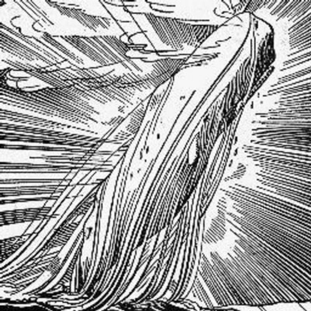
[Illustration portion[. From: Homann, Johann Baptist. (1716). View: Balaenarum Walfische.
This mapping is the substitute for pistol and ball. With a philosophical flourish I quietly take to map making. There is nothing surprising in this. If they but knew it, almost all in their degree, some time or other, cherish very nearly the same feelings towards the ocean of cartography.
01.12.2025 03:40 — 👍 0 🔁 0 💬 1 📌 0
![[map portion] Shows Knocking. From: Geological Survey of Great Britain and Ireland. (1883). Great Britain, Ordnance Survey Office.](https://cdn.bsky.app/img/feed_thumbnail/plain/did:plc:q66r3vy7xepmx62ti4vt7uzb/bafkreidivo3uuhluc4pxsf7tl664sxvaewinvebezhvwwblq5f2ckeersy@jpeg)
[map portion] Shows Knocking. From: Geological Survey of Great Britain and Ireland. (1883). Great Britain, Ordnance Survey Office.
When I find myself growing grim about the mouth; when I find myself pausing before coffin warehouses, and especially when my hypos get an upper hand, that it requires a moral principle to prevent me from stepping into the street, and knocking hats off. Then. I account it high time to get mapping.
01.12.2025 03:40 — 👍 0 🔁 0 💬 1 📌 0
![[modified] Rockwell Kent illustration (Loomings, 1)
[map portion] Geological Survey. (1890). Nantucket sheet. Topographical Survey Commission.
Melville, Herman. (1930). Moby Dick or The Whale. Illustrated by Rockwell Kent. The Modern Library.](https://cdn.bsky.app/img/feed_thumbnail/plain/did:plc:q66r3vy7xepmx62ti4vt7uzb/bafkreiakjclgmu7zzvn4bgacqh2lxju2pwcap7r7gxxg3e2mjbjc4n7ip4@jpeg)
[modified] Rockwell Kent illustration (Loomings, 1)
[map portion] Geological Survey. (1890). Nantucket sheet. Topographical Survey Commission.
Melville, Herman. (1930). Moby Dick or The Whale. Illustrated by Rockwell Kent. The Modern Library.
Call me Oblique. Having little or no planimetric in my purse, and nothing particular to interest me, I thought I would map the watery part of the world. It is a way I have of driving off the spleen and regulating the circulation. Moby-Dick; or, The [Map] #hermapville
01.12.2025 03:40 — 👍 1 🔁 0 💬 1 📌 0

Taddeo Crivelli / Claudius Ptolemy (printed c. 1590)

Taddeo Crivelli / Claudius Ptolemy (printed c. 1590)
Is there a better collection of Cherubs rocking beyond the neatline? #CherubRock
Taddeo Crivelli / Claudius #Ptolemy (printed c. 1590)
tinyurl.com/3w6bbsnw
30.11.2025 23:56 — 👍 3 🔁 0 💬 0 📌 0
Map librarians! How much the more pains ye take to please the world, by so much the more shall ye for ever go thankless! Gulp down your tears; for your friends who have gone before are clearing the heavens against you. Here ye strike splintered hearts—there, ye shall strike unsplinterable glasses!
30.11.2025 03:24 — 👍 1 🔁 0 💬 0 📌 0
So fare thee well, map librarian. Thou belongest to that hopeless, sallow tribe which no wine of this world will ever warm. But with whom one sometimes loves to sit, and grow convivial upon tears; and say to them with full eyes and empty glasses, and in not altogether unpleasant sadness—Give it up!
30.11.2025 03:24 — 👍 0 🔁 0 💬 1 📌 0
You must not, take the higgledy-piggledy map, however authentic, for veritable gospel. These maps are solely valuable, as affording a glancing bird’s eye view of what has been promiscuously said, thought, fancied, and sung of cartography, by many nations and generations, including our own.
30.11.2025 03:24 — 👍 0 🔁 0 💬 1 📌 0
![[modified] Rockwell Kent illustration (Inscribed to Nathaniel Hawthorne)
[portion] Bartlett, J. R. (1884). Pilot chart of the North Atlantic Ocean. December 1884. United States. Naval Oceanographic Office.
Melville, Herman. (1930). Moby Dick or The Whale. Illustrated by Rockwell Kent. The Modern Library.](https://cdn.bsky.app/img/feed_thumbnail/plain/did:plc:q66r3vy7xepmx62ti4vt7uzb/bafkreih7c66sazniubk65qiaeqrmqg2f7aej7hd6rlxwiqnfrtou4d2h2i@jpeg)
[modified] Rockwell Kent illustration (Inscribed to Nathaniel Hawthorne)
[portion] Bartlett, J. R. (1884). Pilot chart of the North Atlantic Ocean. December 1884. United States. Naval Oceanographic Office.
Melville, Herman. (1930). Moby Dick or The Whale. Illustrated by Rockwell Kent. The Modern Library.
EXTRACTS (by a map-map-librarian)
Painstaking burrower and grub-worm of a poor devil. The map librarian appears to have gone through the long street stalls of the earth, picking up whatever random allusions to maps they could find in any book, sacred or profane. Moby-Dick; or, The [MAP] #hermapville
30.11.2025 03:24 — 👍 2 🔁 0 💬 1 📌 0
![[modified] Rockwell Kent illustration (ETYMOLOGY, xiii)
[portion] Hagelgans, Johann Georg. (1718). Atlas Historicus.
Melville, Herman. (1930). Moby Dick or The Whale. Illustrated by Rockwell Kent. The Modern Library.](https://cdn.bsky.app/img/feed_thumbnail/plain/did:plc:q66r3vy7xepmx62ti4vt7uzb/bafkreic7armflt5tpx352jo76w3jkwbzr5poxkocqqpsvknxomygd7k5lm@jpeg)
[modified] Rockwell Kent illustration (ETYMOLOGY, xiii)
[portion] Hagelgans, Johann Georg. (1718). Atlas Historicus.
Melville, Herman. (1930). Moby Dick or The Whale. Illustrated by Rockwell Kent. The Modern Library.
ETYMOLOGY.
The pale map—threadbare. The cartographer, ever dusting old lexicons, with a handkerchief, embellished with all the flags of all the known nations of the world. Map makers loved to dust old grammars; it somehow mildly reminded them of their mortality. Moby-Dick; or, THE [MAP] #hermapville
30.11.2025 01:45 — 👍 15 🔁 2 💬 0 📌 0
Ishmael on the Anthropocene "it’s too late to make any improvements now. The universe is finished; the #copestone is on, and the chips were carted off a million years ago. As old Dives says "give me the privilege of making my own summer with my own coals."
CHAPTER 2. The Carpet-Bag #orTheWhale
23.11.2025 14:10 — 👍 1 🔁 0 💬 0 📌 0
But clicking on your profile I just see this one post not your Mastodon back catalogue… I
21.11.2025 20:41 — 👍 0 🔁 0 💬 1 📌 0
I can see this post
21.11.2025 20:39 — 👍 0 🔁 0 💬 1 📌 0
![[map portion] is from Henry Everett's 1956 map "The Voyage of the Pequod from the Book Moby Dick by Herman Melville.](https://cdn.bsky.app/img/feed_thumbnail/plain/did:plc:q66r3vy7xepmx62ti4vt7uzb/bafkreic7xpe2m6haq3cebjqg6y7nrtax4ov33q4xy624tn2lw6fgzkx3xa@jpeg)
[map portion] is from Henry Everett's 1956 map "The Voyage of the Pequod from the Book Moby Dick by Herman Melville.
Image from Henry Everett's 1956 map "The Voyage of the Pequod from the Book Moby Dick by Herman Melville."
tinyurl.com/mvefb4ws
Ismael, buoyed by a coffin-canoe, "floating on a soft and dirgelike [map]." (Epilogue - Moby Dick or The Whale)
The #map, floating, soft, and #dirgelike...
21.11.2025 13:52 — 👍 4 🔁 0 💬 0 📌 1
A display of various William C. Wonders Map Collection atlas and map reproductions.

cover of Theatrum orbis terrarum--corpus of old atlases in facsimile by Theatrum Orbis Terrarum Ltd.
reproductions/facsimiles are important artifacts for prairie fringe map collections a mini display for some guests last week #WCWMC
Browse the Theatrum orbis terrarum--corpus of old atlases in facsimile by Theatrum Orbis Terrarum Ltd.
archive.org/details/WCWd...
including a "performative" cover
21.11.2025 01:24 — 👍 0 🔁 0 💬 0 📌 0
M-A Murphy. (2020). Revisioning ‘The Visionaries’: A Critical Pedagogy of Place, Settler Implication, and Modes of Selected Remembrance & Erasure on Papaschase Cree Land (University of Alberta campus). Verges: Germanic and Slavic Studies Review.
journals.uvic.ca/index.php/ve...
20.11.2025 01:34 — 👍 0 🔁 0 💬 0 📌 0
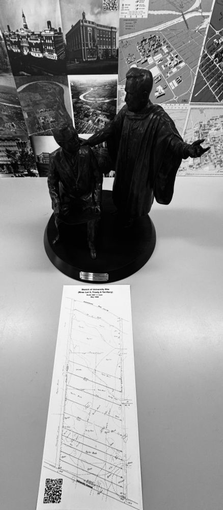
The Visionaries (maquette)
Artist Barbara Paterson
While the statue presents a conversation between the two university founders about the location of the proposed university, there is a deeper, layered history that the statue overlooks. The map held by Rutherford depicts a section of land marked with the number 5, which would become the future home of the University of Alberta. This map illustrates the presence of Métis river lots and specifically marks River Lot 5, along the south bank of the North Saskatchewan River. River Lot 5 was also a place where the Laurent Garneau family lived, played and made a living. River lots were included in the 1882 Dominion of Canada Survey for the settlement of Edmonton, Northwest Territories. The statue, however, provides limited visual information on who was present on the land and suggests that it was uninhabited before the university’s establishment. The history of these lands, prior to European contact in western Canada, included Niitsitapi (Blackfoot), Dene, Néhiyaw (Cree) and Stoney Nakoda Nations. There would have been agreements or treaties in place between these Nations around sharing of the land. In essence, the statue simplifies the layered history of the land and points to the erasure of First Nations presence, of Treaty Six (signed in 1876) history, and the disenfranchisement of the Papaschase Cree Nation and their reserve (No. 136) lands.
Large statues such as “The Visionaries” serve to publicly affirm the history and authority of those who are portrayed in the work. Although intended to celebrate the institutional founding of the University of Alberta, the statue brings to light the importance of acknowledging Indigenous Peoples and lands, and the way complex and layered histories are remembered and commemorated on campus. This is the endeavour of the people who continue to work and study at the University of Alberta today.
University of Alberta Art Collection
University of Alberta Museums

https://www.ualberta.ca/en/museums/museum-collections/art-collection/the-visionaries.html
#Terracotta #TrueScale #GISDay and the Visionaries #maquette dropped in for an orientation session.
www.ualberta.ca/en/museums/m...
#RiverLot5 #Treaty6
20.11.2025 01:34 — 👍 2 🔁 0 💬 1 📌 0
I like map projections and programming: I'm a curious geek.
I like #rstats, #python (but not its pkg system), #smalltalk, #lisp and #observablehq
Community geographer, cartographer, pedestrian, cyclist. Author of "The New American Small Town: Lessons for sustainable urban futures" (West Virginia University Press, June 2025). https://communitygeography.kent.edu/
🇫🇮Suomi-Finland, Tampere🇫🇮
Kuvien kautta katselija, sivusta seuraaja, ekologisten arvojen plsta, sit. harmaahapsi, seuratanssija.
Kuvia myös: https://pixelfed.social/Eeva-Riitta
#valokuvaus #politiikka #arkkitehtuuri #taide #luonto #kukat #tanssi
Following the historical journey of discovery and understanding, through maps, charts and every significant data visualization we can find.
➥ Old Photos, Pics, Paintings, Maps
➥ Docs from Ottoman Empire Archives
➥ Historical Letters, Writings, Poems, Memoirs, Books, Real Human Stories: / Blog: https://ottoman-history-page.blogspot.com
➥ instagram.com/tarihe.seyahat
🪬🧿 Explorer and storyteller. Freemason Discovering Scotland’s hidden history, 🌍
My novel: www.epochofaodhan.com
my yt: www.youtube.com/c/journeydude
Pens: www.luxurywoodenpens.com
Prints: www.scottishwallart.com
🕊️ Peace to all, No AI pls
Official City of Edmonton Account
Active weekdays 8 am-4:30 pm
Report concerns: 311.edmonton.ca
50-year-old indie bookstore in amiskwaciwâskahikan, Alberta. We sell new books, run a podcast called The Audpod, host author events, have a fabulous bunch of well-read booksellers, and are occasionally a bit snarky.
art & architectural historian / visual, material & religious culture
I love to discuss maps, music, books, beer, bicycles, boats, 3D modelling and stereo photography.
I use primarily FOSS tools and often find myself dabbling with QGIS […]
🌉 bridged from ⁂ https://mapstodon.space/@corvus, follow @ap.brid.gy to interact
Bridgy Fed (https://fed.brid.gy/) bot user for the fediverse. To bridge your Bluesky account to the fediverse, follow this account.
To ask a fediverse user to bridge their account, send their address (eg @user@instance) to this account in a chat message.…
PhD Architect and urban planner. My research focuses on shrinking cities and place attachment in Japan.
https://linktr.ee/Pinedaalejandrojuan
Non profit dedicated to restoring and conserving land and water across the United States - over 7,000 acres protected to date!
https://uniqueplacestosave.org
Satellite images past and present 🛰️
Building an archive of interactive declassified spy satellite images 🕵️
https://spacefromspace.com/declassified-satellite-images
ASA Fellow; #rstats developer of graphical methods for categorical and multivariate data; #datavis history of data visualization; #historicaldatavis; Milestones project
Web: www.datavis.ca
GitHub: github.com/friendly
M.Sc. Graduate, KNT University
Photogrammetry | Remote Sensing
Remote Sensing → Environmental Monitoring, Forest Ecology, Wildfire
Photogrammetry → Bundle Adjustment, UAV, Canopy Cover
#RemoteSensing #Photogrammetry #UAV #Drone #DeepLearning #GIS
NDP leadership candidate| MP/Députée Edmonton Strathcona
Change starts with us | À nous le changement 🍊
https://www.heathermcpherson.ca/link_in_bio
Random lines from Moby Dick. Bot conceived, coded, and curated by @samplereality.bsky.social. Follow the companion bot @findmobydick.bsky.social for sources.
Chem Tech, Psychologist, PhD in Soc Sci | Computacional Social Scientist |
Antitrust Data Analyst |
#Rstats, #Bash, #Python, #NLP |
Studying misinformation & hate speech | Coord @labhdufba.bsky.social |
Carthāgō dēlenda est