

Thundersnow in Downtown #Chicago captured by the Chicago Loop Live webcam! This was the first one around 12:23 am. There were two lightning flashes afterwards each spaced roughly 10 mins apart #ilwx ❄️⚡️
10.11.2025 07:20 — 👍 82 🔁 17 💬 1 📌 3Thundersnow in Downtown #Chicago captured by the Chicago Loop Live webcam! This was the first one around 12:23 am. There were two lightning flashes afterwards each spaced roughly 10 mins apart #ilwx ❄️⚡️
10.11.2025 07:20 — 👍 82 🔁 17 💬 1 📌 3


First evidence of thundersnow this evening is on the western periphery of the mesolow, likely over the steel plant near Indiana Dunes National Park. No shortage of tall objects there…more ⚡️ possible as the night goes on near #Chicago
10.11.2025 05:38 — 👍 7 🔁 1 💬 0 📌 0
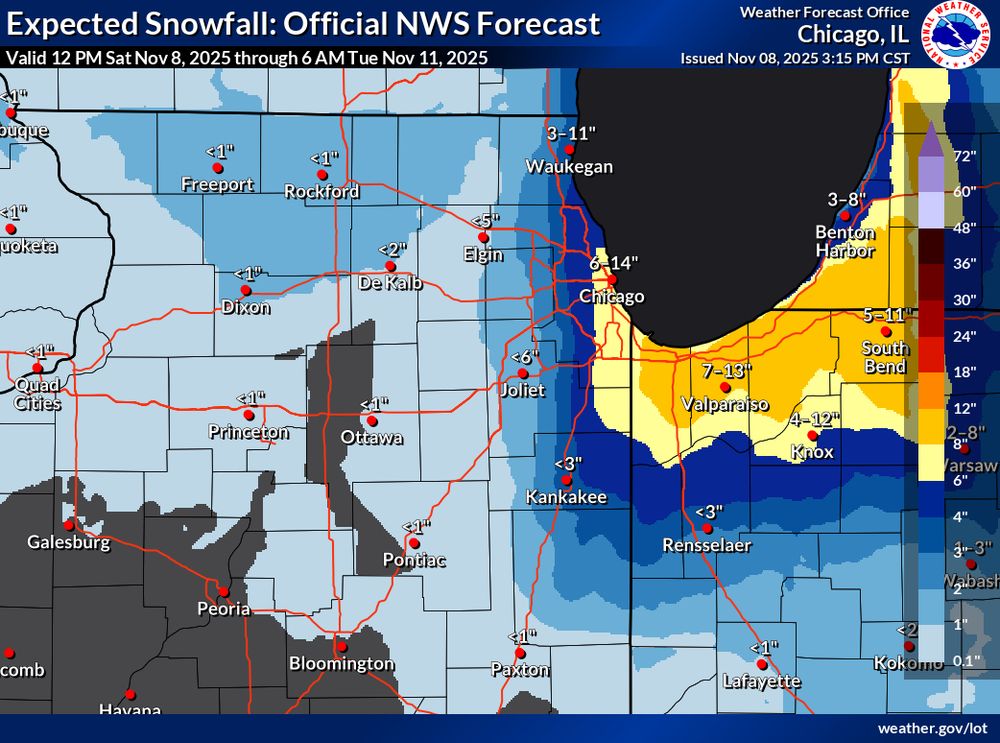
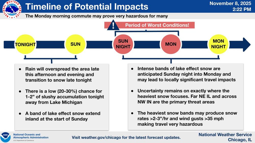

Strong wording regarding lake-effect snow from NWS Chicago this evening.
First snow of the season looking to be quite impactful for the #Chicago metro. Monday morning’s commute could be treacherous ❄️ #ilwx
Graphics from the WPC Cluster Analysis Prototype Page
04.11.2025 03:17 — 👍 2 🔁 0 💬 0 📌 0
(4/4) While there is a signal for colder temps, still it's far too in advance for lower elevation snow to be considered a "lock".
Questions also remain about the extent of the lake response...something definitely worth watching especially this time of year

(3/4) To tie this all together using a phase space diagram, we see clusters 1 or 3 are associated with a stronger trough (note the 3s and 1s towards the right side of the graph). Most members are from ECMWF too (note initialization time).
04.11.2025 03:17 — 👍 1 🔁 0 💬 1 📌 0

(2/4) Using this info, we can cluster models that have similar solutions. For the "classic" lake-effect pattern, clusters 3 and 1 (in that order) look to be most favorable.
Note cluster 1 is what most models are leaning towards, a more mild solution than cluster 3.

(1/4) Lots of talk about the potential for anomalously cold temps and lake-effect precip (snow?) next week.
Details remain uncertain at this lead time, however EOF analysis can provide some insight. Right now, the largest upper-level pattern differences in the models lie in the trough amplitude...


Before and after #HurricaneMelissa …ocean upwelling viewed from NOAA-21
29.10.2025 21:43 — 👍 7 🔁 0 💬 1 📌 1
Whoa 63 dBZ showing up in the lake-effect rain band north of Cleveland, OH this evening!! Likely graupel in there and checkout that lightning #ohwx
23.10.2025 01:06 — 👍 9 🔁 0 💬 0 📌 0


First snow of the season for the high peaks of New England tonight? ❄️ @professorpowder.bsky.social
15.10.2025 15:00 — 👍 3 🔁 0 💬 0 📌 0


This may be one of the first true tests of the Euro AIFS with a warm-core Nor’easter.
Interestingly, the latest 12z run of the deterministic Euro is very different than the AI version. With such a complex meteorology setup it will be interesting to see how this pans out.

Graphic relaying the Key Messages for a forecast strong coastal low expected along the east coast this weekend. - A coastal low is expected to develop off the coast of the Southeast US early Saturday and strengthen through the weekend, bringing significant coastal impacts to parts of the US East Coast through early next week. - The combination of persistent, strong onshore winds, high surf, and high astronomical tides may lead to major coastal flooding for some Mid-Atlantic communities. Coastal residents are urged to heed warnings for their local National Weather Service office and always follow guidance from local officials. - High surf is expected on many East Coast beaches, which will generate strong rip currents and likely lead to areas of beach erosion. - There is an increasing threat of wind gusts in excess of 55mph and periods of heavy rain for coastal areas of the Mid-Atlantic. This may lead to scattered power outages and isolated to scattered instances of flash flooding.
Read the latest key messages regarding the development of a strong coastal low this weekend. Significant coastal impacts are expected along much of the U.S. East Coast through early next week.
Find your local forecast office to keep up with the latest at weather.gov.


October 🤝 warm-core Nor’easters
10.10.2025 02:55 — 👍 8 🔁 2 💬 0 📌 0
Ah that time of year when you can see lake-effect snow 300+ hours on the GFS is back 🙌
06.10.2025 17:54 — 👍 7 🔁 1 💬 0 📌 1
Finally some persistent rain last night in Champaign-Urbana but how much rain fell really depended on what side of town you’re on.
Almost an inch less of rain in Champaign compared to Urbana. Some of those localized downpours didn’t quite make it west. #ilwx #cocorahs

Greetings from the CliMAS Fall 2025 Welcome BBQ!
28.08.2025 23:58 — 👍 13 🔁 3 💬 0 📌 1Not pictured: @70dbz.bsky.social in a Buffalo Bills grilling outfit at today’s welcome back cookout 😅😂
26.08.2025 00:54 — 👍 3 🔁 0 💬 1 📌 0
And we’re back! Day 1 of PhD classes ✅
Ready to start this journey and all that’s to come!
@ztresearch.bsky.social this was another neat one last night!
17.08.2025 13:34 — 👍 0 🔁 0 💬 0 📌 0
More footage of the incredible lightning in Champaign last night. This is in slow motion.
Lasted like this for almost a full hour after the passage of a line of thunderstorms!! #ilwx
I definitely wish I had some long exposure stills but yeah the video is tough to beat!!
17.08.2025 13:08 — 👍 1 🔁 0 💬 0 📌 0It is just an iPhone believe it or not! If you shoot in slo mo it’s a higher frames per second which helps
17.08.2025 12:46 — 👍 1 🔁 0 💬 1 📌 0Thanks for breaking this down!!
17.08.2025 12:17 — 👍 0 🔁 0 💬 0 📌 0Incredible +CG flash!! Negative leaders propagate right to left incloud, then a positive leader develops downward from the decaying negative leader causing a +CG return stroke. Positive leaders with recoil leaders visible below cloud base following the return stroke.
17.08.2025 07:03 — 👍 6 🔁 1 💬 1 📌 0Tonight featured some of the most incredible lightning I’ve ever captured. Taken from Champaign, IL after thunderstorms departed the area!!⚡️ #ilwx @deeplycloudy.bsky.social @stephanieway.bsky.social @frqltg.bsky.social
17.08.2025 05:13 — 👍 55 🔁 5 💬 3 📌 1Anvil crawler lightning looking north in Niantic, CT this evening!! ⛈️ #ctwx
09.07.2025 03:53 — 👍 9 🔁 1 💬 0 📌 0This tornado is a head scratcher for us meteorologists. It occurred in an environment that would not signal for a widespread tornado threat. Rather it spun up quickly near a localized lake breeze front + perhaps outflow boundary from storms to the east too. Shows how nuanced this field can be!!
08.07.2025 20:47 — 👍 4 🔁 0 💬 0 📌 0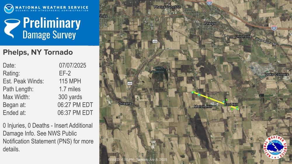
EF-2 tornado confirmed in the Finger Lakes Region of New York yesterday.
Very glad no one was injured here. This storm popped up so quickly and in an area of poor radar coverage! #nywx
Trace of snow officially goes down in the climate report for Binghamton, NY today from hail accumulation #nywx
04.07.2025 03:09 — 👍 3 🔁 0 💬 0 📌 0

