

Aggressive day 3 outlook issued by the SPC - An upper trough pumps a mild, unstable southerly flow bringing with it the chance of severe thunderstorms across the Pacific Northwest.
24.03.2025 16:42 — 👍 17 🔁 3 💬 0 📌 0
Aggressive day 3 outlook issued by the SPC - An upper trough pumps a mild, unstable southerly flow bringing with it the chance of severe thunderstorms across the Pacific Northwest.
24.03.2025 16:42 — 👍 17 🔁 3 💬 0 📌 0
A power outage risk map highlights the highest regions expecting power disruptions including Greater Victoria and southwestern sections of the Lower Mainland.
A look at the power outage threat with a potent, compact low approaching the South Coast Monday evening - localized, but high impacts possible!
24.02.2025 21:41 — 👍 30 🔁 7 💬 1 📌 0
Fantastic question. Winds around a low are caused by the pressure gradient force, a deeper low produces a higher pressure gradient with wind spiralling inward.
Frontal systems are driven by boundaries and temperature gradients, but often the frontal systems across B.C. are attached to the main low


Storm fatigue at its peak: A 975 hPa low south of Tofino is forecast for Boxing Day, far inside 130°W. Another round of damaging winds and widespread power outages are expected. #BCStorm
24.12.2024 22:46 — 👍 36 🔁 7 💬 4 📌 1
A searing red temperature anomaly that shows the most extreme temperature of normal across Nunavut, northern Manitoba, Northern Ontario and western Quebec.

A 7-day temperature forecast for Churchill Manitoba shows highs near freezing and lows of up to -3°. An average low this time of year is -27°.
So, next weekend, the western shores of Hudson Bay will experience temperatures up to 28 degrees above normal, and rainfall will likely be reported across the bay.
24.12.2024 20:17 — 👍 18 🔁 3 💬 2 📌 0Tonight, cheers.
23.12.2024 20:21 — 👍 2 🔁 0 💬 0 📌 0
There is a very high risk of outages for northern sections of the Strait of Georgia, where 100-110 km/h wind gusts are possible over the immediate coastline. Please stay safe! #BCStorm
23.12.2024 19:38 — 👍 22 🔁 3 💬 2 📌 1Remarkable satellite presentation on a rapidly developing low, with a final destination south of Haida Gwaii pre-dawn Tuesday at 960 hPa. #BCStorm
23.12.2024 19:09 — 👍 12 🔁 2 💬 2 📌 0Over 50 mm on the 17-18, super wet by YYJ's standards
21.12.2024 14:38 — 👍 0 🔁 0 💬 0 📌 0
Carefully watching a powerful low approach the NW tip of Vancouver Island pre-dawn Christmas Eve. A low inside 130°W with this pressure normally spells pretty big trouble with power outages and damage for Vancouver Island. #BCStorm
21.12.2024 14:25 — 👍 27 🔁 5 💬 2 📌 1Name three space shuttles.
15.12.2024 00:28 — 👍 1 🔁 0 💬 0 📌 0Classic windstorm for the Lower Mainland on Saturday, with gusts over 90 km/h across the SW, but 80+ km/h wind gusts are fair game well inland. #BCStorm
14.12.2024 14:37 — 👍 24 🔁 3 💬 2 📌 0
Weather model highlighting sustained wind forecast for 9 am on Saturday. Widespread sustained winds of 60-70 km/h in the Strait of Georgia.
Peak winds for most are Saturday morning, easing later Saturday afternoon and evening. For those venturing to the beaches, sustained winds likely touch 70 km/h, the speed where walking and standing becomes more difficult.
14.12.2024 01:39 — 👍 12 🔁 2 💬 0 📌 0
A pressure chart highlighting a deep area of low pressure moving towards northern Vancouver Island.
Widespread power outages are likely, with over a quarter of a million residents potentially losing power. Classic track with the low weakening just northwest of Tofino. Lots of ferry cancellations through through Saturday.
14.12.2024 01:39 — 👍 16 🔁 4 💬 1 📌 0
HRDPS Computer model highlighting peak wind gusts through Saturday evening. Comox: 95 km/h Tofino: 84 km/h Nanaimo: 59 km/h Victoria: 91 km/h Metro Van: 78-105 km/h (highest SW beaches)
The streak of windstorms continues… (1/3🧵) #BCStorm
The forecast is straightforward: if you live along the water, expect wind gusts of up to 100 km/h. The North Island will see much less impact compared to the recent bomb cyclone.
Trash 🤝 Compost
08.12.2024 00:37 — 👍 8 🔁 0 💬 0 📌 0God I wish. I’m too busy biking these days.
05.12.2024 15:35 — 👍 1 🔁 0 💬 0 📌 0
Vehicles on the interstate driving in foggy conditions
Heavy fog through the #Chehalis Valley with limited visibility… use caution, slow down, and make sure your headlights are on if travelling in that area or whenever travelling in fog!
#ShareYourWeather #WAwx

Surface air quality can be impacted with the warm air aloft acting as a “lid,” trapping fine particulate matter.
27.11.2024 14:34 — 👍 5 🔁 0 💬 0 📌 0
Want to escape the gloom? Up, up and away!
27.11.2024 14:34 — 👍 6 🔁 0 💬 1 📌 0
Here’s the classic result—our marine layer blanket gets extra cozy along the coast.
27.11.2024 14:34 — 👍 1 🔁 0 💬 1 📌 0
Meet our Pacific Northwest high-pressure ridge that’s forecast over the coming days.
www.theweathernetwork.com/en/news/weat...
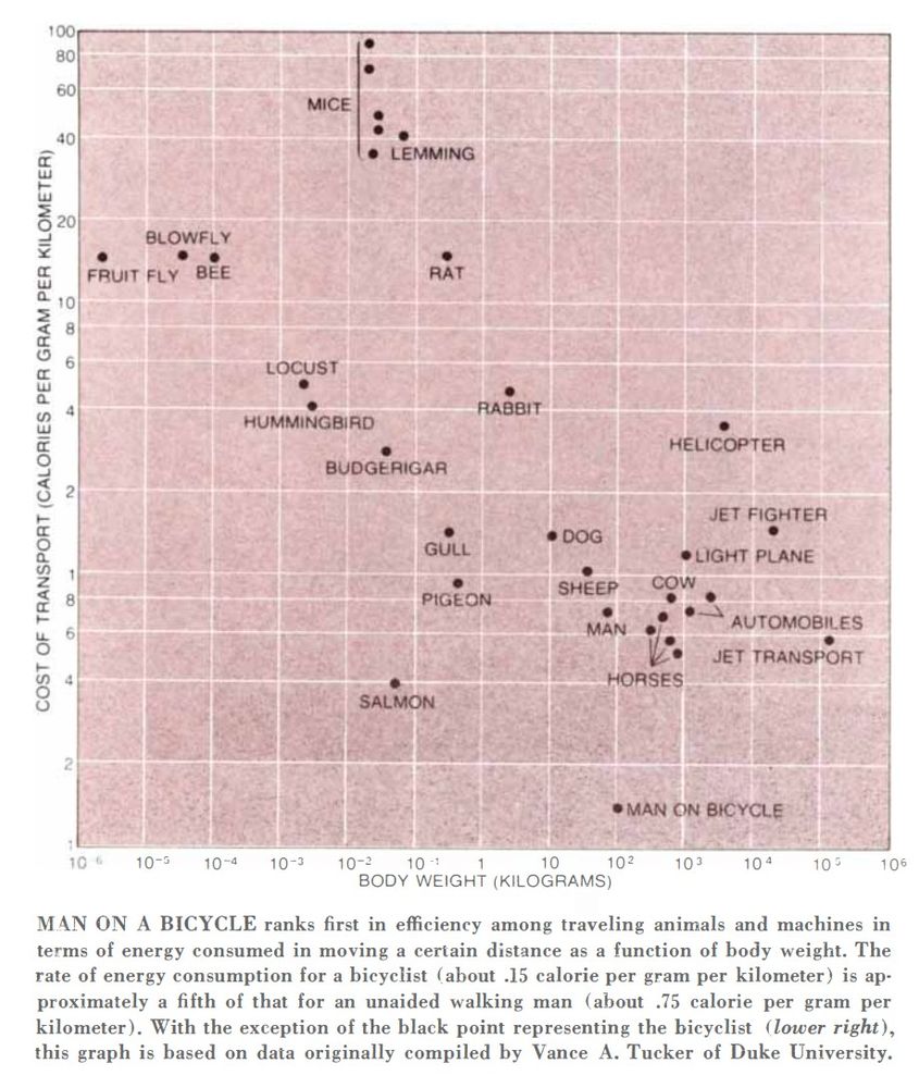
A graph titled "Cost of Transport" showing the relationship between body weight (in kilograms) and energy consumption for distance traveled (calories per gram per kilometer) for various animals and machines. It highlights that a person on a bicycle ranks first in efficiency.
A person on a bicycle is by far the most energy-efficient among animals and machines per distance traveled relative to body weight. The bicycle is magic.
www.jstor.org/stable/24923...
Brilliant piece.
25.11.2024 04:11 — 👍 2 🔁 0 💬 0 📌 0My childhood in a meal.
23.11.2024 00:13 — 👍 3 🔁 0 💬 0 📌 0


Buoy Y43, a few hundred meters off the Ucluelet coast. Doing it's job during the Bomb Cyclone yesterday. I want to dedicate these photos to the First Responders, BC Hydro & other folks who work through these event to try to keep us safe #Ukee #Ucluelet #BombCyclone #BCStorm #VancouverIsland #PNW
21.11.2024 19:43 — 👍 48 🔁 7 💬 2 📌 0
Nailed it!
21.11.2024 02:56 — 👍 10 🔁 2 💬 0 📌 0
The atmosphere is pulling off its best impersonation of a Tim Hortons Smile Cookie this week.
21.11.2024 02:27 — 👍 53 🔁 3 💬 2 📌 0What it's like to watch a plane land during a bomb cyclone. 💨✈️ #wawx
20.11.2024 05:23 — 👍 99 🔁 21 💬 10 📌 3
A surface weather analysis showing a 942 mb low west of Washington with an occluded front wrapping around it.
WPC analysis shows the #BombCyclone bottomed out at 942 mb at 03z (19 PT). This ties the record set in October 2021.
#weather #BCstorm #WAwx #ORwx


