

The Department of Earth Sciences and St Peter's College are recruiting an Associate Professor (or Professor) in Earth Surface Processes to join our thriving academic community!
earth.web.ox.ac.uk/vacancies
The Department of Earth Sciences and St Peter's College are recruiting an Associate Professor (or Professor) in Earth Surface Processes to join our thriving academic community!
earth.web.ox.ac.uk/vacancies
⚒️🧪Fiery Mud Volcano Eruption!
The Daşmərdan (Dashmardan) mud volcano in Azerbaijan erupted ~16:50 on the 30th Jan 2026. The eruption lasted ~15 mins and was accompanied by a pillar of flame several hundred meters high. Daşmərdan had previous documented eruptions in 1866, 1954, 1976, 1986 and 2011.

When paleoseismology becomes uncomfortable: a short fault scarp in a mature orogen.
By @speleojacek.bsky.social and Christoph
paleoseismicity.org/when-paleose...

New fully-funded DPhil project with Professor Richard Walker (@richardthomasw.bsky.social) researching the extent, timing, and cause of Quaternary uplift along the Atlantic margin of Morocco!
For more information visit our website
www.earth.ox.ac.uk/extent-timin...


China has started to build a mega dam across Yigong Tsangpo River. Risky venture ? IMO, yes.
Valleys have steep side that are prone to landslides - some have created landslide dams that blocked the river. These have later failed generating a massive flood.
earthobservatory.nasa.gov/images/78293...
Very nice! @faultydata.bsky.social
04.12.2025 07:45 — 👍 1 🔁 0 💬 0 📌 0

23 November 1405
Mw7.5 earthquake destroyed Neyshabur/Nishapur, Rasavi Khorasan province, NE Iran, burying in its ruins many of the inhabitants. Other devastating EQs hit the town in 1209, 1270, 1389 and 1673.
doi.org/10.2307/4299...
doi.org/10.1785/BSSA...
doi.org/10.1785/BSSA...
Iran is facing its worst drought since at least six decades! 😱🔥💧
As a result the iconic Damavand (5,609 m asl), Iran's highest peak, was snow-free at mid-autumn, which appears to be unprecedented! ❄️😰
This stratovolcano had a 3.4 km ice cover in 2002... likely gone today! 🧊 📈
📽️ @IranIntl_En
UTTERLY SURREAL LOW ANGLE GLACIER SLIDE!! 😮😱
On Saturday at 11:00 am, a 2 km-long, 25 m-high, and 150-200 m in width section detached off the Ismoil Somoni Glacier (Tajikistan) and slid down the gorge! 🧊🌊
asiaplustj.info/en/node/354309
📽️ via @volcaholic1

Perspective view showing merged topography and bathymetry for the South Caspian Basin and its surroundings, with the coastlines shown as thin black lines. Faults are mapped with solid lines for higher confidence and dashed lines for lower confidence. NE-SW trending folds in the deeper parts of the basin are shown using dashed lines with diamond decorations. Large submarine landslides visible in the bathymetry are highlighted with translucent polygons. GNSS data from Kadirov et al. (2014) shows the convergence of the Kura Basin with Eurasia taken up by the KFTB and the Caucasus. The triangular region bounded by the Alat Fault and the Sumquayit Fault is moving eastward relative to the Kura Basin, and appears to extrude into the SCB, possibly contributing the folding of offshore sediments. The South Caspian Basin (SCB) velocity vector located offshore is from Dodds et al. (2022) who used the rates of the basin-bounding faults to infer the velocity of the basin.
Published in #GJI Geophysical Journal International: "Fault creep in the fluid-rich Kura Basin, Azerbaijan, imaged with InSAR", Johnson et al. This is Fig. 11: read the paper at academic.oup.com/gji/article/... @oxfordacademic.bsky.social @royalastrosoc.bsky.social
12.09.2025 08:23 — 👍 4 🔁 2 💬 0 📌 1
Zakeria Shnizai was featured on the BBC Science in Action podcast this week, speaking about the recent #earthquakes in #Afghanistan and the main causes of the country’s vulnerability to earthquakes
Listen here: www.bbc.co.uk/sounds/play/...
Link to the paper published in TEKTONIKA #DOAJ @wearetektonika.bsky.social 2/2 ⚒️
tektonika.online/index.php/ho...

Geological cross section across the Jalalabad basin shows several thrust faults dipping to the north-west
Section 👇 from Shnizai & Walker in Tektonika 2024 @wearetektonika.bsky.social shows structure of Jalalabad basin, E #Afghanistan.
It's not right across the recent #earthquake but more to the W. The earthquake may have occurred on a thrust fault equivalent to the one to the left of the section. 1/2 ⚒️
Yes, completely. We were just passing through and had a short stop
20.08.2025 17:13 — 👍 1 🔁 0 💬 0 📌 0
We happened to visit the rupture today, on their anniversary!
19.08.2025 12:05 — 👍 2 🔁 0 💬 1 📌 0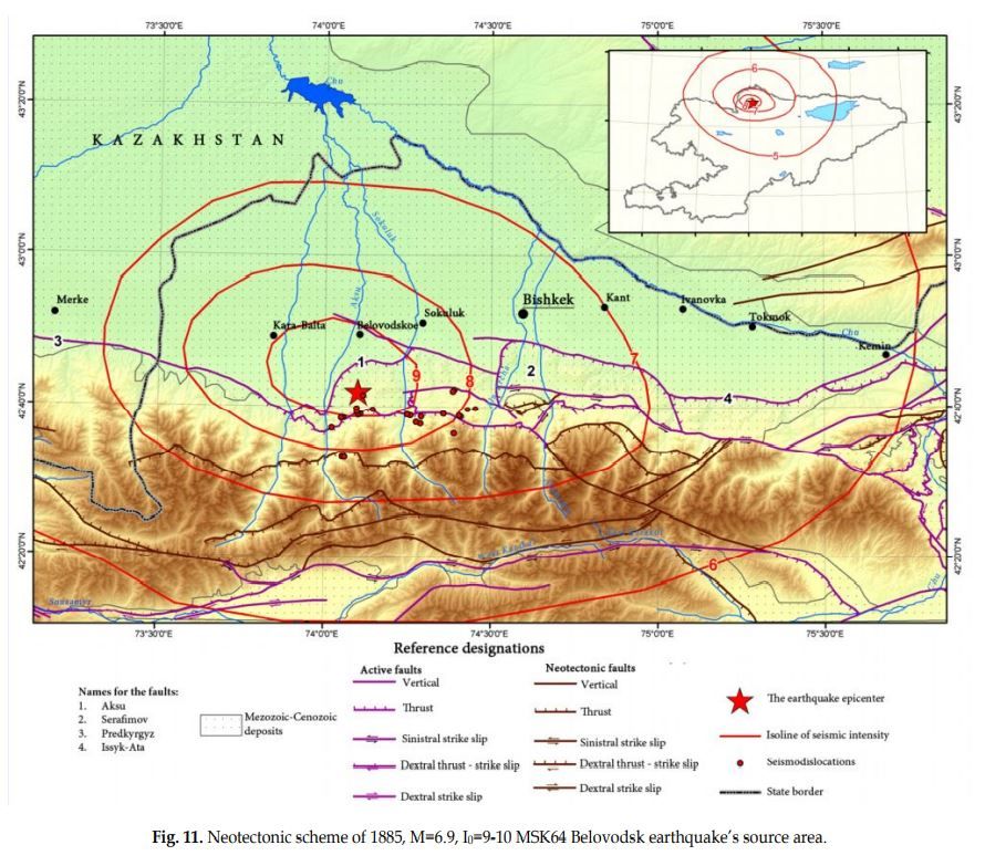
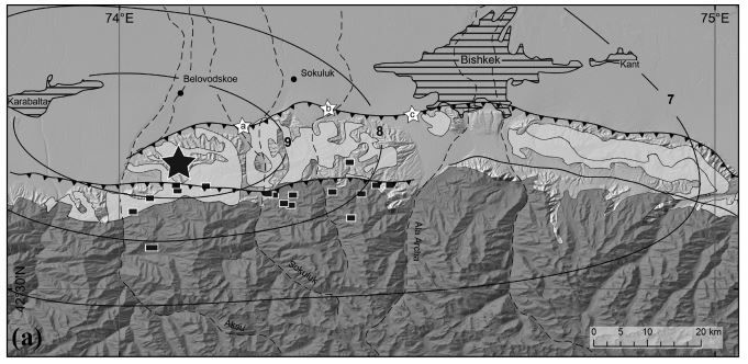
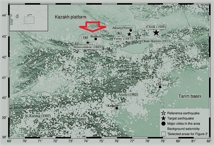
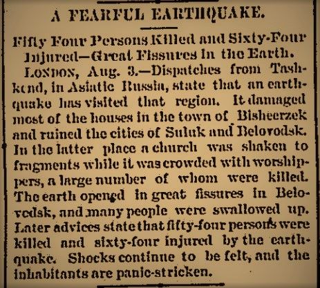
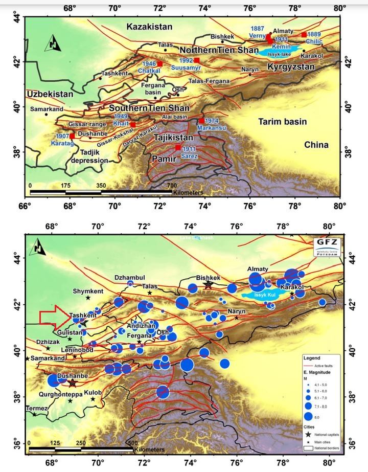
2 August 1885 21:20 UT (2:20 of 3rd LT)
M6.9-7.6 earthquake destroyed Belodovskoe and Karabalta, west of Bishkek (Kyrgyzstan), killing 54 people. Other Northern Tien Chan EQs in 1887, 1889 and 1911.
caiag.kg/en/projects/...
academic.oup.com/gji/article/...
nyshistoricnewspapers.org/lccn/sn83045...
Very happy to share this documentary that documents some of the work of our team and our collaborators in learning more about the earthquakes of Central Asia. @jrarrowsmith.bsky.social
18.06.2025 14:35 — 👍 8 🔁 3 💬 0 📌 0
SPEECHLESS BEFORE / AFTER #BLATTEN
The magnitude of destruction after the 3:24 pm collapse of Birch Glacier is immense! 😱
All the forest has been razed and the ice/wood/debris dammed the Lonza river 🌊
Some buildings of Blatten are buried 🏠
📷 Pomona
Watch the ground break and move during the magnitude 7.7 #Myanmar #earthquake. This footage shows the incredible power of the earthquake that devastated parts of Myanmar and #Thailand. My thoughts are with the people impacted by this event. 💔
🧪⚒️
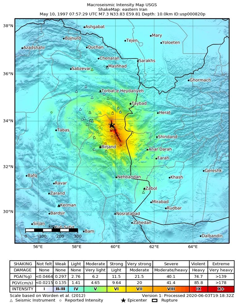
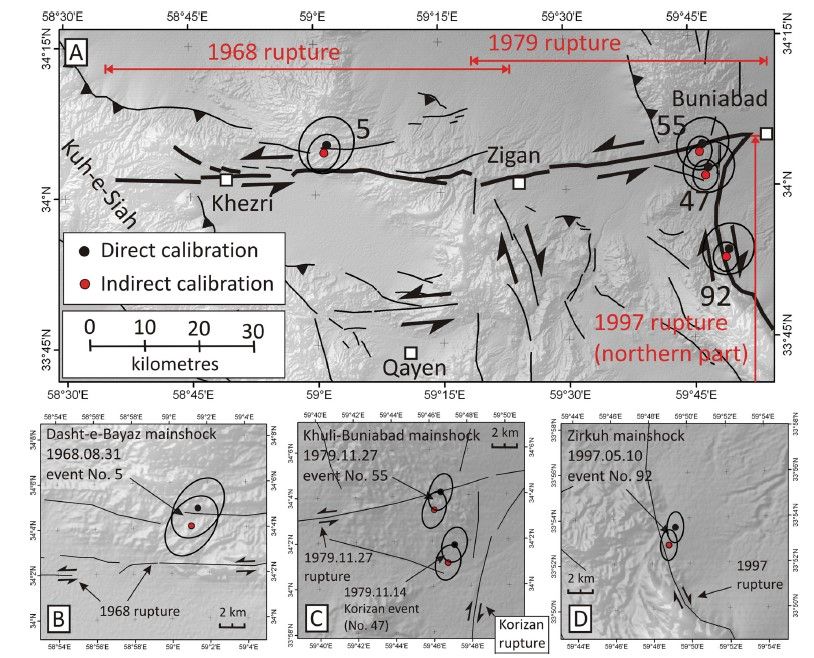
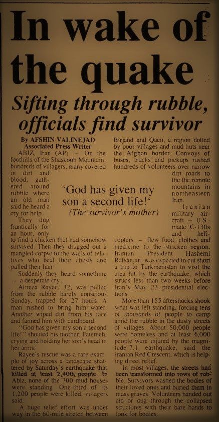
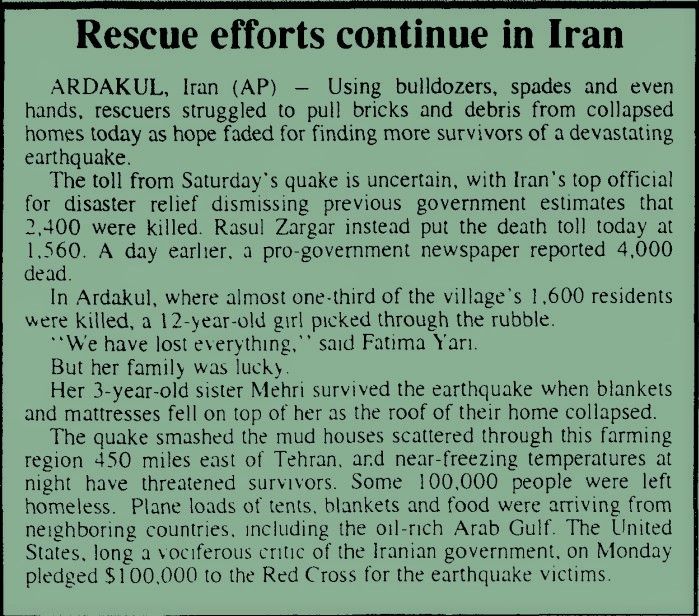
10 May 1997 7:58 UT
Mw7.3 Zirkuh earthquake along Abiz Fault, east of Qaen, South Khorasan, NE Iran, destroyed 10,000 houses, killing 1567 people in Iran and 5 in Afghanistan. The seismic sequence begun in 1968.
earthquake.usgs.gov/earthquakes/...
doi.org/10.1111/j.13...
nyshistoricnewspapers.org
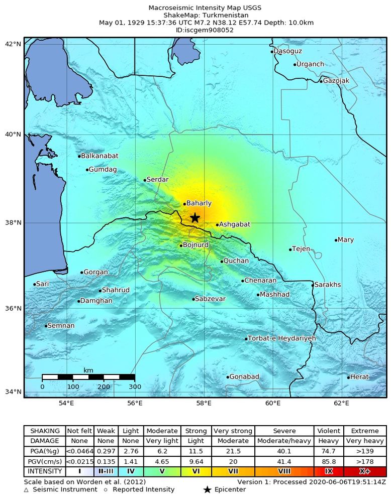
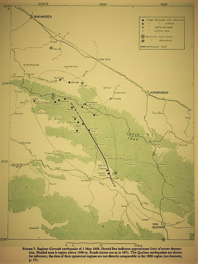
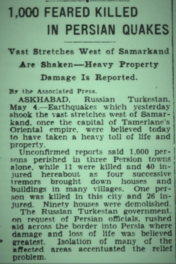
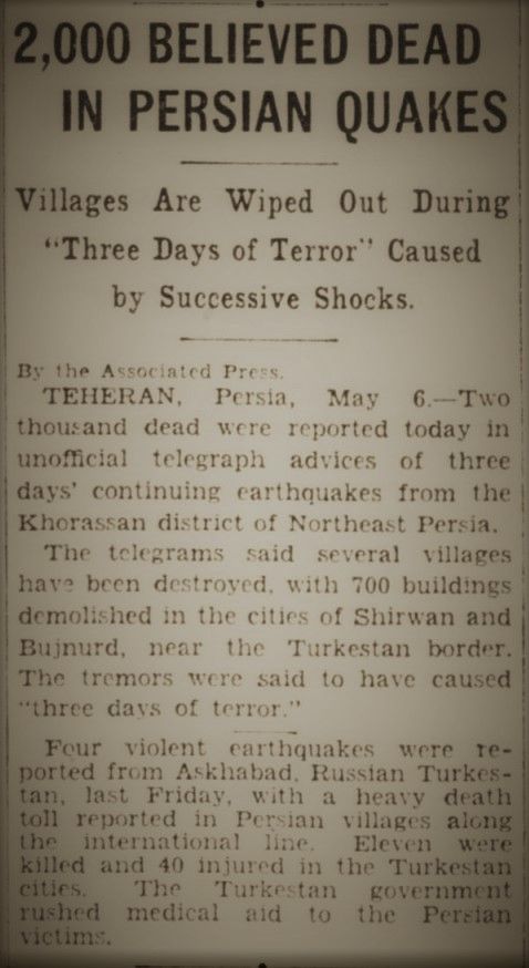
1 May 1929 15:38 UT
Mw7.2 earthquake and aftershocks, in the Kopet Dag, at Iran-Turkmenistan border, destroyed villages and caused 3800 deaths, most in Iran. The Quchan 1871-95 EQs were in the same fault zone.
earthquake.usgs.gov/earthquakes/...
jstor.org/stable/74468...
chroniclingamerica.loc.gov
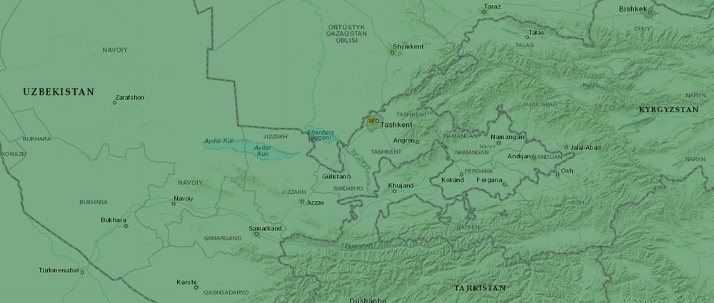
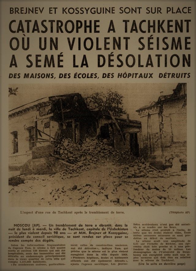
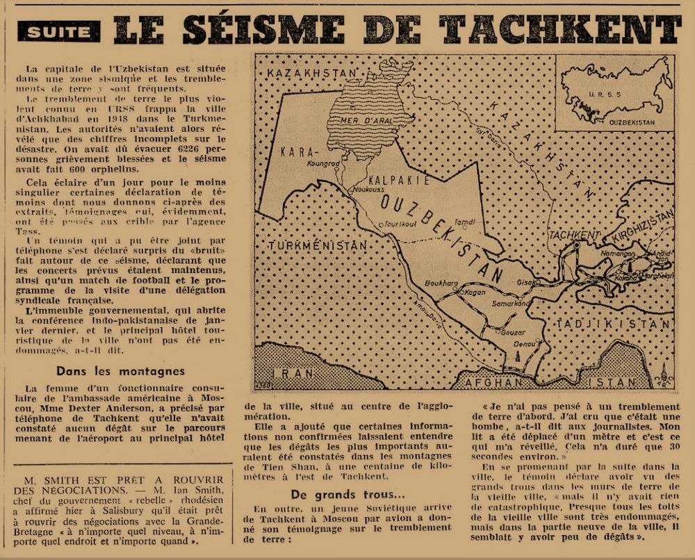
25 April 1966 23:23 UT (5:23 of 26th LT)
Mw5.2 earthquake destroyed Tashkent, Uzbekistan, killing 15 to 200 people and leaving 300,000 homeless - very shallow and near urban center.
earthquake.usgs.gov/earthquakes/...
doi.org/10.1016/j.so...
en.wikipedia.org/wiki/1966_Ta...
e-newspaperarchives.ch

We are excited to be a part of a new multidisciplinary research initiative for sustainable natural resources. The Oxford EARTH programme aims to address the challenges in natural resources underpinning the net zero energy transition 🌎
25.03.2025 16:44 — 👍 8 🔁 4 💬 1 📌 0
A short introduction to the Miocene paleogeography of #Almeria and the #Alboran sea by Hannah Fry ‘Geology is cool man..’
youtube.com/shorts/jt9Wv...
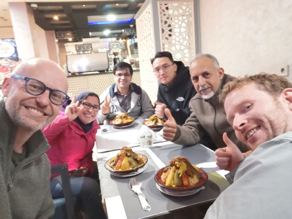
Our blog has been a bit quiet over these winter months, but I have added a new article describing our recent trip to Morocco, working with scientists from Mohammed V University in Rabat to understand more about earthquake sources around the Atlas mountains.
quakesincentralasia.org/research-upd...
The team is now fully assembled for the Atlas mountains fieldtrip! Looking forward to seeing some faults tomorrow
28.02.2025 18:51 — 👍 10 🔁 1 💬 0 📌 0These deep water sources are likely to be increasingly important, but we know so little of their global distribution due to lack of data and study. Repurposed industrial data may hold the key!
28.02.2025 12:15 — 👍 3 🔁 0 💬 0 📌 0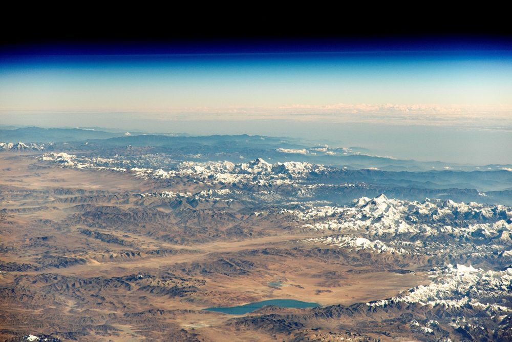
A new study highlights the rising risks of sliding slopes in High Mountain Asia nsidc.org/news-analyse...
Supplementing the research paper, the researchers released a new dataset, the 'High Mountain Asia Daily 5km Landslide HazaAccrd Indicator'.
@davepetley.bsky.social @richardthomasw.bsky.social
Many thanks for the link @dpmanchee.bsky.social
19.02.2025 19:36 — 👍 1 🔁 0 💬 0 📌 0
We wrote a recent paper on the potential source of this earthquake, based upon paleoseismic trenching - see agupubs.onlinelibrary.wiley.com/doi/full/10....
13.02.2025 15:26 — 👍 2 🔁 1 💬 0 📌 0


