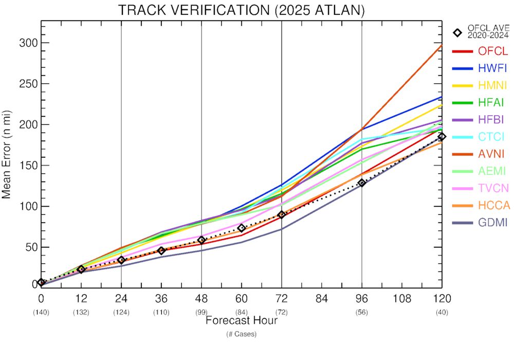

New set of preliminary track and intensity verification stats for the 2025 Atlantic hurricane season so far, including NHC ("OFCL"), 5 hurricane models, 2 global models for track or 2 dynamical/statistical for intensity, 2 consensus, and the new Google DeepMind model's ensemble mean ("GDMI").
22.10.2025 22:26 — 👍 30 🔁 11 💬 4 📌 0
Whoa winds at this North Sea rig associated with the bomb cyclone partly from the remnants of Humberto.
METAR ENJS 032050Z 15073G94KT 1500 RA BR OVC007 13/12 Q0972 W13/S7
03.10.2025 20:59 — 👍 1 🔁 0 💬 1 📌 0
The center appeared to go right over Pratas Island. There used to be a weather observation site there but I am not currently finding anything.
24.09.2025 20:23 — 👍 2 🔁 0 💬 0 📌 0

D-PRINT now showing an intensity of 44 knots for #95L
tropic.ssec.wisc.edu/real-time/DP...
03.08.2025 18:52 — 👍 3 🔁 0 💬 2 📌 0
This really is a huge blow to our ability to monitor tropical cyclones. There are at least 5 TC algorithms we run that rely on this data to estimate the intensity and structure of TCs, including the potential for rapid intensification. The satellites are still providing quality data. Makes sense.
27.06.2025 15:12 — 👍 2 🔁 0 💬 0 📌 0
Any good observations from the western side of the island?
13.06.2025 21:05 — 👍 1 🔁 0 💬 1 📌 0


TC #Errol has been weakening over the last several hours after undergoing extreme RI from a TS to Cat 5 in 24 hours. The shear appears light and ssts still very warm so the likely candidate is an ERC. The microwave eye is a bit larger than previously and looks disrupted perhaps supporting that.
17.04.2025 02:38 — 👍 2 🔁 0 💬 0 📌 0
And it has a significant outbreak of globally detectable lightning around the center of circulation, like Milton.
Lightning data via Vaisala GLD360.
16.04.2025 13:02 — 👍 11 🔁 5 💬 0 📌 0

March 2025: The Month of Dust.
Neat view of dust plume stretched from Gulf Coast to Midwest.
19.03.2025 15:33 — 👍 112 🔁 27 💬 5 📌 5

Note that we have now added OCEANSAT and HYSAT to our TC page. Nice coverage for newly designated storm 26S indicating winds of at least 35 knots.
18.03.2025 20:45 — 👍 1 🔁 0 💬 0 📌 0

TC #Garance made a direct hit on La Reunion. Thankfully it was undergoing rapid weakening at the time and also moving steady enough to not stall over or near the island. While rainfall totals were extreme they could have been worse with a slower moving large system.
28.02.2025 19:07 — 👍 3 🔁 0 💬 0 📌 0

Tropical Cyclone Garance dropped 469.6 mm = 18.49 inches of rain at Piton-Maido. There are reports of flooding from La Reunion.
28.02.2025 13:56 — 👍 0 🔁 1 💬 0 📌 0
La #Réunion est en Alerte Violette 🟣 alors que le Cyclone Tropical intense #Garance traverse l'île.
234 km/h viennent d'etre mesurés à Gros Piton Sainte-Rose avec un vent moyen de 166 km/h ⚠️ meteociel.fr/r/Obs_Gros_P...
Nous avons aussi ajouté la lame radar pour la Réunion ⤵️
28.02.2025 07:28 — 👍 10 🔁 3 💬 0 📌 1
The National Hurricane Center set an all-time record for forecast accuracy in 2024 » Yale Climate Connections
But the investments in hurricane research that led to the new record are threatened by proposed budget cuts.
The most deadly hurricane in US history was the one they had no warning of - the Galveston Hurricane of 1900. So this is good news from @drjeffmasters.bsky.social. Warnings save lives!
27.02.2025 01:40 — 👍 568 🔁 122 💬 10 📌 9

World rainfall records at risk? Foc-Foc, La Réunion (elev. 2,290m or 7,513’) holds the record for 12 hours: 1.144m (45”) and 24 hours: 1.825m (71.8”), Jan. 7-8, 1966, during Cyclone Denise (low-end tropical storm with 40 mph winds). #Garance is expected to hit as a Cat 3; HAFS-A model says a Cat 4.
27.02.2025 18:30 — 👍 72 🔁 27 💬 4 📌 3

The SHEM is very active. At one point 6 TCs at once. TC Rae is now post-tropical.
26.02.2025 20:21 — 👍 2 🔁 0 💬 0 📌 0
No thunder here in Madison but seeing convective looking precip on radar was nice :)
26.02.2025 20:16 — 👍 1 🔁 0 💬 0 📌 0
MIMIC
Keep in mind for some of these sensors the resolution degrades near the edge of the scan so the eye will not be resolved and the system will "look" worse. Here is a similar animation with higher resolution sensors.
tropic.ssec.wisc.edu/real-time/mi...
14.02.2025 18:38 — 👍 0 🔁 0 💬 1 📌 0

Cat 4 Cyclone Zelia hits Western Australia » Yale Climate Connections
Record-warm ocean temperatures helped Zelia intensify.
Earth's 1st major landfalling tropical cyclone of 2025 was Cyclone Zelia in Western Australia. Fortunately, it hit a relatively sparsely populated area. Zelia was just the 19th Cat 4 or stronger cyclone to hit Australia since 1961. yaleclimateconnections.org/2025/02/cat-...
14.02.2025 16:24 — 👍 35 🔁 12 💬 0 📌 0
We're off to the races in terms of fuel for the coming months of severe weather. The current Gulf-wide average SST of around 24C (75F) is a record for mid-Feb, and more typical of what you'd expect in late April.
kouya.has.arizona.edu/tropics/SSTm...
14.02.2025 15:57 — 👍 24 🔁 10 💬 0 📌 1
Thanks everyone!
14.02.2025 17:00 — 👍 1 🔁 0 💬 0 📌 0


Cyclone #Zelia appears to be in the process of an Eyewall Replacement Cycle (ERC). Visible in microwave imagery (MIMIC-TC) and the radar from Port Headland.
13.02.2025 17:22 — 👍 2 🔁 0 💬 0 📌 0


Satellite intensity estimates continue to rapidly increase for Cyclone Zelia with some now up near 90 knots with the eye trying to clear out in the infrared.
12.02.2025 19:10 — 👍 0 🔁 0 💬 0 📌 0
Not too far away from convection again here :)
11.02.2025 19:44 — 👍 1 🔁 0 💬 0 📌 0
Hi All, like many of you I am here trying to rebuild the networks I had on Twitter. I could use some help amplifying an opportunity for students. We are hosting a Virtual Science Fair again this year. If you have education contacts can you please share with them?
cimss.ssec.wisc.edu/jpss-vsf/
11.02.2025 19:32 — 👍 10 🔁 7 💬 1 📌 0
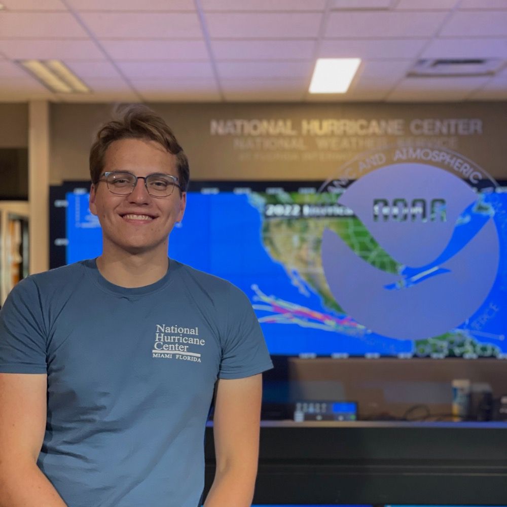
M.S. student at Colorado State University studying tropical cyclones + airborne radar. B.S. CS + Atmospheric/Oceanic Sciences from UW-Madison.
Also enjoys diving + photography + storm chasing + television + Wisconsin Sports + F1
Associate Professor #VirginiaTech studying tropical cyclones. Alum @UFGeog @psumeteo & @RUMeteorology. Pittsburgh native. Run, hike, swim #RecoveryIsPossible
Hurricane Specialist and Storm Surge Expert at Miami's WPLG-TV Local 10 News. Posts my own.
http://linktr.ee/michaelrlowry
Tropical meteorologist, B.S. FSU, amateur web, Python, & GrADS programmer.
Also known as Not Sparta
Associate professor, Atmospheric and Environmental Sciences at UAlbany. Tropical cyclones & severe weather. Occasionally playing hockey, skiing, or paddleboarding.
I study high-impact weather, help develop high-resolution models to improve weather forecasts, and mentor scientists. Constantly striving to help those around me flourish. My views expressed here are mine alone.
Professor of Atmospheric Science at
University of Miami, Hurricane Expert, and Weather Consultant at rfqweather.com
Atmospheric scientist. Ideater. Curiously Creative. Liaisoneer. @NWSWPC HydroMetTestbed Coordinator @ CU Boulder.
He/Him
#signaldetection #science #cats #birding
Weather, climate, writing, #scicomm, teaching, LIW, history, sports, wagering, equity. Book WILDER WEATHER coming in 2025. Nebraska/Midwest/Michigan. She/her. #binders #amwriting
Assistant Professor at the University of Miami. Usually discussing hurricanes.
Meteorologist, homebrewer, Forward Madison, Chelsea, USA, AFC Wimbledon. Data data data.
Professor and Chair, Department of Atmospheric & Environmental Sciences, The University at Albany. Avid Boston sports fan. Not ready to make nice. #LFG
Senior meteorological scientist at @windbornewx.bsky.social & web developer
Weather-Climate professor and scientist, Host of Weather Geeks, Forbes Senior Contributor, Alpha, 3xFSU Alum...Tweets and RTs are mine but not endorsements
Professor and Head, Department of Climate, Meteorology & Atmospheric Sciences, University of Illinois. AMS Fellow; I'm a meteorologist that brakes for interesting cloud formations. Opinions mine. #BillsMafia linktr.ee/70_dbz
NOAA Weather Program Office Science, Technology, & Society Division Chief. Risk Communication expert. Passionate about the intersection of weather, research, applications, and society. Opinions are my own.
Research meteorologist at NSF NCAR, specializing in tropical meteorology and the science behind weather prediction. Hurricane aficionado.
🇺🇸/🇩🇪
Senior Scientist @windbornewx.bsky.social . Weather model nerd. Dallas area sports fan. Knitter, sci-fi and fantasy reader, cook and baker. Reluctant but obsessive politics follower. 📍 Bay Area
Cash app : $TempestRevolt
Opinions my own.
Professor and Chair@UW_AOS Meteorology, Ecology, Climate Sci (Biosphere-Atmos) Parent to 3 kid chaos. Https://flux.aos.wisc.edu