FFC updates Flood Watch (cancels Catoosa, Chattooga, Dade, Walker, Whitfield [GA], extends time and expands area to include Banks, Barrow, Clarke, Emanuel, Fannin, Glascock, Greene... at Mon, 04 Aug 2025 16:33:46 +0000 via IEMbot
Additional Details Here.
04.08.2025 16:46 — 👍 0 🔁 0 💬 0 📌 0
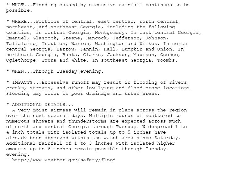
* WHAT...Flooding caused by excessive rainfall continues to be
possible.
* WHERE...Portions of central, east central, north central,
northeast, and southeast Georgia, including the following
counties, in central Georgia, Montgomery. In east central Georgia,
Emanuel, Glascock, Greene, Hancock, Jefferson, Johnson,
Taliaferro, Treutlen, Warren, Washington and Wilkes. In north
central Georgia, Barrow, Fannin, Hall, Lumpkin and Union. In
northeast Georgia, Banks, Clarke, Jackson, Madison, Oconee,
Oglethorpe, Towns and White. In southeast Georgia, Toombs.
* WHEN...Through Tuesday evening.
* IMPACTS...Excessive runoff may result in flooding of rivers,
creeks, streams, and other low-lying and flood-prone locations.
Flooding may occur in poor drainage and urban areas.
* ADDITIONAL DETAILS...
- A very moist airmass will remain in place across the region
over the next several days. Multiple rounds of scattered to
numerous showers and thunderstorms are expected across much
of north and central Georgia through Tuesday. Widespread 1 to
4 inch totals with isolated totals up to 5 inches have
already been observed within the watch area since Saturday.
Additional rainfall of 1 to 3 inches with isolated higher
amounts up to 6 inches remain possible through Tuesday
evening.
- http://www.weather.gov/safety/flood
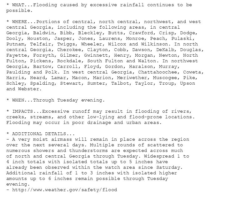
* WHAT...Flooding caused by excessive rainfall continues to be
possible.
* WHERE...Portions of central, north central, northwest, and west
central Georgia, including the following areas, in central
Georgia, Baldwin, Bibb, Bleckley, Butts, Crawford, Crisp, Dodge,
Dooly, Houston, Jasper, Jones, Laurens, Monroe, Peach, Pulaski,
Putnam, Telfair, Twiggs, Wheeler, Wilcox and Wilkinson. In north
central Georgia, Cherokee, Clayton, Cobb, Dawson, DeKalb, Douglas,
Fayette, Forsyth, Gilmer, Gwinnett, Henry, Morgan, Newton, North
Fulton, Pickens, Rockdale, South Fulton and Walton. In northwest
Georgia, Bartow, Carroll, Floyd, Gordon, Haralson, Murray,
Paulding and Polk. In west central Georgia, Chattahoochee, Coweta,
Harris, Heard, Lamar, Macon, Marion, Meriwether, Muscogee, Pike,
Schley, Spalding, Stewart, Sumter, Talbot, Taylor, Troup, Upson
and Webster.
* WHEN...Through Tuesday evening.
* IMPACTS...Excessive runoff may result in flooding of rivers,
creeks, streams, and other low-lying and flood-prone locations.
Flooding may occur in poor drainage and urban areas.
* ADDITIONAL DETAILS...
- A very moist airmass will remain in place across the region
over the next several days. Multiple rounds of scattered to
numerous showers and thunderstorms are expected across much
of north and central Georgia through Tuesday. Widespread 1 to
4 inch totals with isolated totals up to 5 inches have
already been observed within the watch area since Saturday.
Additional rainfall of 1 to 3 inches with isolated higher
amounts up to 6 inches remain possible through Tuesday
evening.
- http://www.weather.gov/safety/flood
🚨 Flood Watch issued August 4 at 12:33PM EDT until August 5 at 8:00PM EDT by NWS Peachtree City GA 🚨
Additional Details Here.
04.08.2025 16:45 — 👍 0 🔁 0 💬 0 📌 0
FFC issues Area Forecast Discussion (AFD) at Aug 4, 10:22 AM EDT ...Morning Update... via IEMbot
Additional Details Here.
04.08.2025 14:26 — 👍 0 🔁 0 💬 0 📌 0
WCO issues Area Hydrological Discussion (AHD) at Aug 4, 7:56 AM CDT
at Mon, 04 Aug 2025 13:11:28 +0000 via IEMbot
Additional Details Here.
04.08.2025 13:26 — 👍 0 🔁 0 💬 0 📌 0
Weather Prediction Center issues Mesoscale Precipitation Discussion #864 concerning HEAVY RAINFALL...FLASH FLOODING POSSIBLE
at Mon, 04 Aug 2025 11:41:39 +0000 via IEMbot
Additional Details Here.
04.08.2025 11:46 — 👍 2 🔁 0 💬 0 📌 0
FFC issues Area Forecast Discussion (AFD) at Aug 4, 6:50 AM EDT ...New 12Z Aviation Discussion... via IEMbot
Additional Details Here.
04.08.2025 11:06 — 👍 0 🔁 0 💬 0 📌 0
FFC issues Hazardous Weather Outlook (HWO) at Aug 4, 6:00 AM EDT
at Mon, 04 Aug 2025 10:00:25 +0000 via IEMbot
Additional Details Here.
04.08.2025 10:06 — 👍 0 🔁 0 💬 0 📌 0
FFC issues Area Forecast Discussion (AFD) at Aug 4, 4:47 AM EDT ...Morning Area Forecast Discussion... via IEMbot
Additional Details Here.
04.08.2025 09:06 — 👍 0 🔁 0 💬 0 📌 0
FFC issues Area Forecast Discussion (AFD) at Aug 4, 4:06 AM EDT ...New 06Z Aviation Discussion... via IEMbot
Additional Details Here.
04.08.2025 08:26 — 👍 0 🔁 0 💬 0 📌 0
COLUMBUS Aug 3
Climate Report:
High: 81
Low: 65
Precip: Trace
Snow: Missing
at Mon, 04 Aug 2025 08:25:29 +0000 via IEMbot
Additional Details Here.
04.08.2025 08:26 — 👍 0 🔁 0 💬 0 📌 0
FFC issues Area Forecast Discussion (AFD) at Aug 3, 10:14 PM EDT ...Evening Update... via IEMbot
Additional Details Here.
04.08.2025 02:26 — 👍 0 🔁 0 💬 0 📌 0
FFC issues Hazardous Weather Outlook (HWO) at Aug 3, 9:50 PM EDT
at Mon, 04 Aug 2025 01:51:39 +0000 via IEMbot
Additional Details Here.
04.08.2025 02:06 — 👍 0 🔁 0 💬 0 📌 0
MACON Aug 3
Climate Report:
High: 74
Low: 67
Precip: 0.4"
Snow: Missing
at Mon, 04 Aug 2025 00:33:49 +0000 via IEMbot
Additional Details Here.
04.08.2025 00:46 — 👍 0 🔁 0 💬 0 📌 0
ATHENS Aug 3
Climate Report:
High: 71
Low: 64
Precip: 1.31"
Snow: Missing
at Mon, 04 Aug 2025 00:33:49 +0000 via IEMbot
Additional Details Here.
04.08.2025 00:46 — 👍 0 🔁 0 💬 0 📌 0
DEKALB PEACHTREE AIRPORT Aug 3
Climate Report:
High: 72
Low: 65
Precip: 1.28"
Snow: Missing
at Mon, 04 Aug 2025 00:33:49 +0000 via IEMbot
Additional Details Here.
04.08.2025 00:46 — 👍 0 🔁 0 💬 0 📌 0
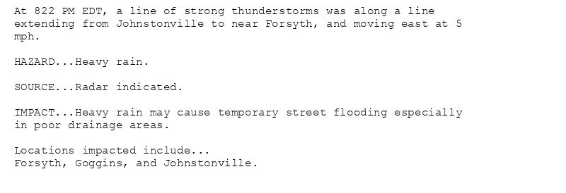
At 822 PM EDT, a line of strong thunderstorms was along a line
extending from Johnstonville to near Forsyth, and moving east at 5
mph.
HAZARD...Heavy rain.
SOURCE...Radar indicated.
IMPACT...Heavy rain may cause temporary street flooding especially
in poor drainage areas.
Locations impacted include...
Forsyth, Goggins, and Johnstonville.
Special Weather Statement issued August 3 at 8:23PM EDT by NWS Peachtree City GA
Additional Details Here.
04.08.2025 00:30 — 👍 0 🔁 0 💬 0 📌 0
FFC cancels Flood Warning for Coahulla Creek at Keiths Mill Road near Dalton [GA]
at Mon, 04 Aug 2025 00:12:30 +0000 via IEMbot
Additional Details Here.
04.08.2025 00:26 — 👍 0 🔁 0 💬 0 📌 0
FFC issues Area Forecast Discussion (AFD) at Aug 3, 7:29 PM EDT ...New 00Z Aviation Discussion... via IEMbot
Additional Details Here.
03.08.2025 23:46 — 👍 0 🔁 0 💬 0 📌 0
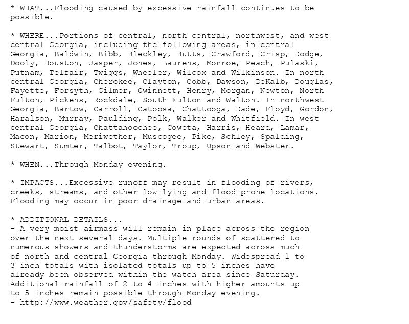
* WHAT...Flooding caused by excessive rainfall continues to be
possible.
* WHERE...Portions of central, north central, northwest, and west
central Georgia, including the following areas, in central
Georgia, Baldwin, Bibb, Bleckley, Butts, Crawford, Crisp, Dodge,
Dooly, Houston, Jasper, Jones, Laurens, Monroe, Peach, Pulaski,
Putnam, Telfair, Twiggs, Wheeler, Wilcox and Wilkinson. In north
central Georgia, Cherokee, Clayton, Cobb, Dawson, DeKalb, Douglas,
Fayette, Forsyth, Gilmer, Gwinnett, Henry, Morgan, Newton, North
Fulton, Pickens, Rockdale, South Fulton and Walton. In northwest
Georgia, Bartow, Carroll, Catoosa, Chattooga, Dade, Floyd, Gordon,
Haralson, Murray, Paulding, Polk, Walker and Whitfield. In west
central Georgia, Chattahoochee, Coweta, Harris, Heard, Lamar,
Macon, Marion, Meriwether, Muscogee, Pike, Schley, Spalding,
Stewart, Sumter, Talbot, Taylor, Troup, Upson and Webster.
* WHEN...Through Monday evening.
* IMPACTS...Excessive runoff may result in flooding of rivers,
creeks, streams, and other low-lying and flood-prone locations.
Flooding may occur in poor drainage and urban areas.
* ADDITIONAL DETAILS...
- A very moist airmass will remain in place across the region
over the next several days. Multiple rounds of scattered to
numerous showers and thunderstorms are expected across much
of north and central Georgia through Monday. Widespread 1 to
3 inch totals with isolated totals up to 5 inches have
already been observed within the watch area since Saturday.
Additional rainfall of 2 to 4 inches with higher amounts up
to 5 inches remain possible through Monday evening.
- http://www.weather.gov/safety/flood
🚨 Flood Watch issued August 3 at 7:41PM EDT until August 4 at 8:00PM EDT by NWS Peachtree City GA 🚨
Additional Details Here.
03.08.2025 23:45 — 👍 0 🔁 0 💬 0 📌 0
ATLANTA Aug 3
Climate Report:
High: 74
Low: 67
Precip: 1.45"
Snow: Missing
at Sun, 03 Aug 2025 20:37:59 +0000 via IEMbot
Additional Details Here.
03.08.2025 20:46 — 👍 1 🔁 0 💬 0 📌 0
PEACHTREE CITY Aug 3
Climate Report:
High: 74
Low: 66
Precip: 1.61"
Snow: Missing
at Sun, 03 Aug 2025 20:37:59 +0000 via IEMbot
Additional Details Here.
03.08.2025 20:46 — 👍 1 🔁 0 💬 0 📌 0
FFC cancels Flood Warning for Pew Creek at Patterson Road near Lawrenceville [GA]
at Sun, 03 Aug 2025 19:57:48 +0000 via IEMbot
Additional Details Here.
03.08.2025 20:06 — 👍 0 🔁 0 💬 0 📌 0
1 NE Covington [Newton Co, GA] Emergency Mngr reports Flash Flood at 10:40 AM EDT -- Pictures and video showed flooded parking lots and water entering some housing units at the Cov... at Sun, 03 Aug 2025 19:14:04 +0000 via IEMbot
Additional Details Here.
03.08.2025 19:26 — 👍 1 🔁 0 💬 0 📌 0
FFC issues Area Forecast Discussion (AFD) at Aug 3, 2:46 PM EDT ...Afternoon Area Forecast Discussion... via IEMbot
Additional Details Here.
03.08.2025 19:06 — 👍 0 🔁 0 💬 0 📌 0
FFC issues Area Forecast Discussion (AFD) at Aug 3, 2:07 PM EDT ...New 18Z Aviation Discussion... via IEMbot
Additional Details Here.
03.08.2025 18:26 — 👍 0 🔁 0 💬 0 📌 0
Weather Prediction Center issues Mesoscale Precipitation Discussion #860 concerning HEAVY RAINFALL...FLASH FLOODING POSSIBLE
at Sun, 03 Aug 2025 17:09:35 +0000 via IEMbot
Additional Details Here.
03.08.2025 17:26 — 👍 0 🔁 0 💬 0 📌 0
FFC cancels Flash Flood Warning for Newton, Rockdale, Walton [GA]
at Sun, 03 Aug 2025 16:56:30 +0000 via IEMbot
Additional Details Here.
03.08.2025 17:06 — 👍 0 🔁 0 💬 0 📌 0
FFC extends time of Flood Warning for Coahulla Creek at Keiths Mill Road near Dalton [GA] till Aug 4, 12:12 AM EDT
at Sun, 03 Aug 2025 14:32:02 +0000 via IEMbot
Additional Details Here.
03.08.2025 14:46 — 👍 0 🔁 0 💬 0 📌 0
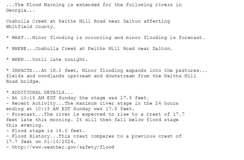
...The Flood Warning is extended for the following rivers in
Georgia...
Coahulla Creek at Keiths Mill Road near Dalton affecting
Whitfield County.
* WHAT...Minor flooding is occurring and minor flooding is forecast.
* WHERE...Coahulla Creek at Keiths Mill Road near Dalton.
* WHEN...Until late tonight.
* IMPACTS...At 18.0 feet, Minor flooding expands into the pastures...
fields and woodlands upstream and downstream from the Keiths Mill
Road bridge.
* ADDITIONAL DETAILS...
- At 10:15 AM EDT Sunday the stage was 17.5 feet.
- Recent Activity...The maximum river stage in the 24 hours
ending at 10:15 AM EDT Sunday was 17.5 feet.
- Forecast...The river is expected to rise to a crest of 17.7
feet late this morning. It will then fall below flood stage
this evening.
- Flood stage is 16.0 feet.
- Flood History...This crest compares to a previous crest of
17.7 feet on 01/10/2024.
- http://www.weather.gov/safety/flood
🚨 Flood Warning issued August 3 at 10:31AM EDT until August 4 at 12:12AM EDT by NWS Peachtree City GA 🚨
Additional Details Here.
03.08.2025 14:45 — 👍 0 🔁 0 💬 0 📌 0
FFC issues Area Forecast Discussion (AFD) at Aug 3, 9:56 AM EDT ...Morning Update... via IEMbot
Additional Details Here.
03.08.2025 14:06 — 👍 0 🔁 0 💬 0 📌 0