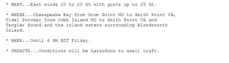
* WHAT...East winds 10 to 20 kt with gusts up to 25 kt.
* WHERE...Chesapeake Bay from Drum Point MD to Smith Point VA,
Tidal Potomac from Cobb Island MD to Smith Point VA and
Tangier Sound and the inland waters surrounding Bloodsworth
Island.
* WHEN...Until 6 PM EDT Friday.
* IMPACTS...Conditions will be hazardous to small craft.
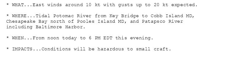
* WHAT...East winds around 10 kt with gusts up to 20 kt expected.
* WHERE...Tidal Potomac River from Key Bridge to Cobb Island MD,
Chesapeake Bay north of Pooles Island MD, and Patapsco River
including Baltimore Harbor.
* WHEN...From noon today to 6 PM EDT this evening.
* IMPACTS...Conditions will be hazardous to small craft.
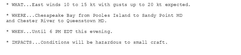
* WHAT...East winds 10 to 15 kt with gusts up to 20 kt expected.
* WHERE...Chesapeake Bay from Pooles Island to Sandy Point MD
and Chester River to Queenstown MD.
* WHEN...Until 6 PM EDT this evening.
* IMPACTS...Conditions will be hazardous to small craft.
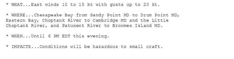
* WHAT...East winds 10 to 15 kt with gusts up to 20 kt.
* WHERE...Chesapeake Bay from Sandy Point MD to Drum Point MD,
Eastern Bay, Choptank River to Cambridge MD and the Little
Choptank River, and Patuxent River to Broomes Island MD.
* WHEN...Until 6 PM EDT this evening.
* IMPACTS...Conditions will be hazardous to small craft.
Small Craft Advisory issued August 7 at 5:05AM EDT until August 8 at 6:00PM EDT by NWS Baltimore MD/Washington DC
Additional Details Here.(1/2)
07.08.2025 09:15 — 👍 0 🔁 0 💬 0 📌 0
LWX issues Area Forecast Discussion (AFD) at Aug 7, 3:52 AM EDT
at Thu, 07 Aug 2025 07:52:54 +0000 via IEMbot
Additional Details Here.
07.08.2025 08:06 — 👍 0 🔁 0 💬 0 📌 0
MARTINSBURG WV Aug 6
Climate Report:
High: 76
Low: 64
Precip: 0.0"
Snow: Missing
at Thu, 07 Aug 2025 07:03:02 +0000 via IEMbot
Additional Details Here.
07.08.2025 07:06 — 👍 1 🔁 1 💬 0 📌 0
HAGERSTOWN MD Aug 6
Climate Report:
High: 78
Low: 67
Precip: 0.05"
Snow: Missing
at Thu, 07 Aug 2025 07:03:03 +0000 via IEMbot
Additional Details Here.
07.08.2025 07:06 — 👍 1 🔁 1 💬 0 📌 0
LWX issues Area Forecast Discussion (AFD) at Aug 6, 9:13 PM EDT
at Thu, 07 Aug 2025 01:13:56 +0000 via IEMbot
Additional Details Here.
07.08.2025 01:26 — 👍 0 🔁 0 💬 0 📌 0
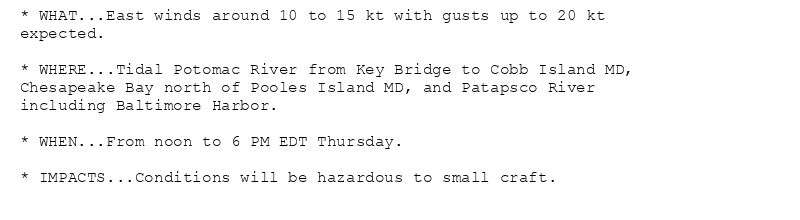
* WHAT...East winds around 10 to 15 kt with gusts up to 20 kt
expected.
* WHERE...Tidal Potomac River from Key Bridge to Cobb Island MD,
Chesapeake Bay north of Pooles Island MD, and Patapsco River
including Baltimore Harbor.
* WHEN...From noon to 6 PM EDT Thursday.
* IMPACTS...Conditions will be hazardous to small craft.
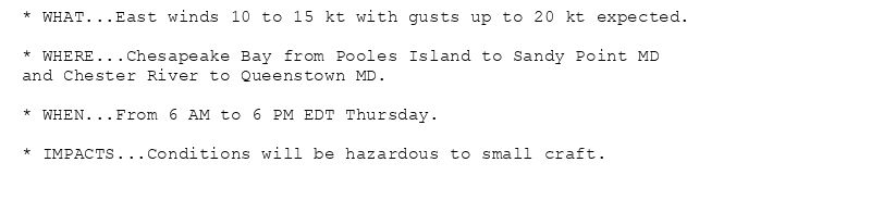
* WHAT...East winds 10 to 15 kt with gusts up to 20 kt expected.
* WHERE...Chesapeake Bay from Pooles Island to Sandy Point MD
and Chester River to Queenstown MD.
* WHEN...From 6 AM to 6 PM EDT Thursday.
* IMPACTS...Conditions will be hazardous to small craft.
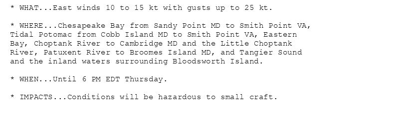
* WHAT...East winds 10 to 15 kt with gusts up to 25 kt.
* WHERE...Chesapeake Bay from Sandy Point MD to Smith Point VA,
Tidal Potomac from Cobb Island MD to Smith Point VA, Eastern
Bay, Choptank River to Cambridge MD and the Little Choptank
River, Patuxent River to Broomes Island MD, and Tangier Sound
and the inland waters surrounding Bloodsworth Island.
* WHEN...Until 6 PM EDT Thursday.
* IMPACTS...Conditions will be hazardous to small craft.
Small Craft Advisory issued August 6 at 9:00PM EDT until August 7 at 6:00PM EDT by NWS Baltimore MD/Washington DC
Additional Details Here.
07.08.2025 01:15 — 👍 0 🔁 0 💬 0 📌 0
HAGERSTOWN MD Aug 6
Climate Report:
High: 78
Low: 67
Precip: 0.0"
Snow: Missing
at Wed, 06 Aug 2025 21:24:36 +0000 via IEMbot
Additional Details Here.
06.08.2025 21:26 — 👍 0 🔁 0 💬 0 📌 0
CHARLOTTESVILLE VA Aug 6
Climate Report:
High: 75
Low: 62
Precip: 0.02"
Snow: Missing
at Wed, 06 Aug 2025 21:24:36 +0000 via IEMbot
Additional Details Here.
06.08.2025 21:26 — 👍 0 🔁 0 💬 0 📌 0
LWX issues Area Forecast Discussion (AFD) at Aug 6, 2:55 PM EDT
at Wed, 06 Aug 2025 18:55:30 +0000 via IEMbot
Additional Details Here.
06.08.2025 19:06 — 👍 0 🔁 0 💬 0 📌 0
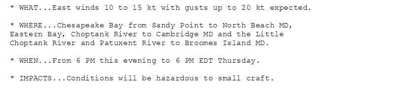
* WHAT...East winds 10 to 15 kt with gusts up to 20 kt expected.
* WHERE...Chesapeake Bay from Sandy Point to North Beach MD,
Eastern Bay, Choptank River to Cambridge MD and the Little
Choptank River and Patuxent River to Broomes Island MD.
* WHEN...From 6 PM this evening to 6 PM EDT Thursday.
* IMPACTS...Conditions will be hazardous to small craft.
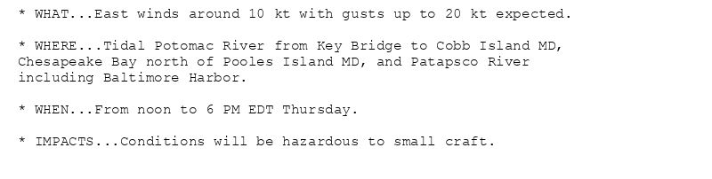
* WHAT...East winds around 10 kt with gusts up to 20 kt expected.
* WHERE...Tidal Potomac River from Key Bridge to Cobb Island MD,
Chesapeake Bay north of Pooles Island MD, and Patapsco River
including Baltimore Harbor.
* WHEN...From noon to 6 PM EDT Thursday.
* IMPACTS...Conditions will be hazardous to small craft.
* WHAT...East winds 10 to 15 kt with gusts up to 20 kt expected.
* WHERE...Chesapeake Bay from Pooles Island to Sandy Point MD
and Chester River to Queenstown MD.
* WHEN...From 6 AM to 6 PM EDT Thursday.
* IMPACTS...Conditions will be hazardous to small craft.
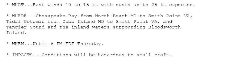
* WHAT...East winds 10 to 15 kt with gusts up to 25 kt expected.
* WHERE...Chesapeake Bay from North Beach MD to Smith Point VA,
Tidal Potomac from Cobb Island MD to Smith Point VA, and
Tangier Sound and the inland waters surrounding Bloodsworth
Island.
* WHEN...Until 6 PM EDT Thursday.
* IMPACTS...Conditions will be hazardous to small craft.
Small Craft Advisory issued August 6 at 1:52PM EDT until August 7 at 6:00PM EDT by NWS Baltimore MD/Washington DC
Additional Details Here.(1/2)
06.08.2025 18:00 — 👍 0 🔁 0 💬 0 📌 0
LWX issues Area Forecast Discussion (AFD) at Aug 6, 10:19 AM EDT
at Wed, 06 Aug 2025 14:19:49 +0000 via IEMbot
Additional Details Here.
06.08.2025 14:26 — 👍 0 🔁 0 💬 0 📌 0
* WHAT...East winds 10 to 15 kt with gusts up to 20 kt expected.
* WHERE...Chesapeake Bay from Sandy Point to North Beach MD,
Eastern Bay, Choptank River to Cambridge MD and the Little
Choptank River and Patuxent River to Broomes Island MD.
* WHEN...From 6 PM this evening to 6 PM EDT Thursday.
* IMPACTS...Conditions will be hazardous to small craft.
* WHAT...East winds around 10 kt with gusts up to 20 kt expected.
* WHERE...Tidal Potomac River from Key Bridge to Cobb Island MD,
Chesapeake Bay north of Pooles Island MD, and Patapsco River
including Baltimore Harbor.
* WHEN...From noon to 6 PM EDT Thursday.
* IMPACTS...Conditions will be hazardous to small craft.
* WHAT...East winds 10 to 15 kt with gusts up to 20 kt expected.
* WHERE...Chesapeake Bay from Pooles Island to Sandy Point MD
and Chester River to Queenstown MD.
* WHEN...From 6 AM to 6 PM EDT Thursday.
* IMPACTS...Conditions will be hazardous to small craft.
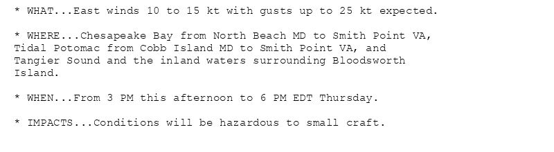
* WHAT...East winds 10 to 15 kt with gusts up to 25 kt expected.
* WHERE...Chesapeake Bay from North Beach MD to Smith Point VA,
Tidal Potomac from Cobb Island MD to Smith Point VA, and
Tangier Sound and the inland waters surrounding Bloodsworth
Island.
* WHEN...From 3 PM this afternoon to 6 PM EDT Thursday.
* IMPACTS...Conditions will be hazardous to small craft.
Small Craft Advisory issued August 6 at 6:15AM EDT until August 7 at 6:00PM EDT by NWS Baltimore MD/Washington DC
Additional Details Here.(1/2)
06.08.2025 10:30 — 👍 0 🔁 0 💬 0 📌 0
LWX issues Area Forecast Discussion (AFD) at Aug 6, 3:49 AM EDT
at Wed, 06 Aug 2025 07:49:48 +0000 via IEMbot
Additional Details Here.
06.08.2025 08:06 — 👍 0 🔁 0 💬 0 📌 0
HAGERSTOWN MD Aug 5
Climate Report:
High: 86
Low: 63
Precip: 0.0"
Snow: Missing
at Wed, 06 Aug 2025 06:28:18 +0000 via IEMbot
Additional Details Here.
06.08.2025 06:46 — 👍 0 🔁 0 💬 0 📌 0
BALTIMORE INNER HARBOR Aug 5
Climate Report:
High: 88
Low: 74
Precip: 0.0"
Snow: Missing
at Wed, 06 Aug 2025 06:28:19 +0000 via IEMbot
Additional Details Here.
06.08.2025 06:46 — 👍 0 🔁 0 💬 0 📌 0
* WHAT...East winds 10 to 15 kt with gusts up to 20 kt expected.
* WHERE...Chesapeake Bay from Sandy Point to North Beach MD,
Eastern Bay, Choptank River to Cambridge MD and the Little
Choptank River and Patuxent River to Broomes Island MD.
* WHEN...From 6 PM this evening to 6 PM EDT Thursday.
* IMPACTS...Conditions will be hazardous to small craft.
* WHAT...East winds around 10 kt with gusts up to 20 kt expected.
* WHERE...Tidal Potomac River from Key Bridge to Cobb Island MD,
Chesapeake Bay north of Pooles Island MD, and Patapsco River
including Baltimore Harbor.
* WHEN...From noon to 6 PM EDT Thursday.
* IMPACTS...Conditions will be hazardous to small craft.
* WHAT...East winds 10 to 15 kt with gusts up to 20 kt expected.
* WHERE...Chesapeake Bay from Pooles Island to Sandy Point MD
and Chester River to Queenstown MD.
* WHEN...From 6 AM to 6 PM EDT Thursday.
* IMPACTS...Conditions will be hazardous to small craft.
* WHAT...East winds 10 to 15 kt with gusts up to 25 kt expected.
* WHERE...Chesapeake Bay from North Beach MD to Smith Point VA,
Tidal Potomac from Cobb Island MD to Smith Point VA, and
Tangier Sound and the inland waters surrounding Bloodsworth
Island.
* WHEN...From 3 PM this afternoon to 6 PM EDT Thursday.
* IMPACTS...Conditions will be hazardous to small craft.
Small Craft Advisory issued August 6 at 2:19AM EDT until August 7 at 6:00PM EDT by NWS Baltimore MD/Washington DC
Additional Details Here.(1/2)
06.08.2025 06:30 — 👍 0 🔁 0 💬 0 📌 0
LWX issues Area Forecast Discussion (AFD) at Aug 5, 9:14 PM EDT
at Wed, 06 Aug 2025 01:15:55 +0000 via IEMbot
Additional Details Here.
06.08.2025 01:26 — 👍 0 🔁 0 💬 0 📌 0
LWX issues Area Forecast Discussion (AFD) at Aug 5, 5:32 PM EDT
at Tue, 05 Aug 2025 21:33:22 +0000 via IEMbot
Additional Details Here.
05.08.2025 21:46 — 👍 0 🔁 0 💬 0 📌 0
LWX issues Area Forecast Discussion (AFD) at Aug 5, 2:23 PM EDT
at Tue, 05 Aug 2025 18:23:54 +0000 via IEMbot
Additional Details Here.
05.08.2025 18:26 — 👍 0 🔁 0 💬 0 📌 0
LWX issues Area Forecast Discussion (AFD) at Aug 5, 9:39 AM EDT
at Tue, 05 Aug 2025 13:40:03 +0000 via IEMbot
Additional Details Here.
05.08.2025 13:46 — 👍 0 🔁 0 💬 0 📌 0
LWX issues Area Forecast Discussion (AFD) at Aug 5, 3:58 AM EDT
at Tue, 05 Aug 2025 07:58:47 +0000 via IEMbot
Additional Details Here.
05.08.2025 08:06 — 👍 0 🔁 0 💬 0 📌 0
CHARLOTTESVILLE VA Aug 4
Climate Report:
High: 83
Low: 55
Precip: 0.0"
Snow: Missing
at Tue, 05 Aug 2025 06:29:06 +0000 via IEMbot
Additional Details Here.
05.08.2025 06:46 — 👍 0 🔁 0 💬 0 📌 0
BALTIMORE INNER HARBOR Aug 4
Climate Report:
High: 91
Low: 68
Precip: 0.0"
Snow: Missing
at Tue, 05 Aug 2025 06:29:07 +0000 via IEMbot
Additional Details Here.
05.08.2025 06:46 — 👍 0 🔁 0 💬 0 📌 0
LWX issues Area Forecast Discussion (AFD) at Aug 4, 8:58 PM EDT
at Tue, 05 Aug 2025 00:59:01 +0000 via IEMbot
Additional Details Here.
05.08.2025 01:06 — 👍 0 🔁 0 💬 0 📌 0
HAGERSTOWN MD Aug 4
Climate Report:
High: 85
Low: 58
Precip: 0.0"
Snow: Missing
at Mon, 04 Aug 2025 21:36:07 +0000 via IEMbot
Additional Details Here.
04.08.2025 21:46 — 👍 0 🔁 0 💬 0 📌 0
BALTIMORE INNER HARBOR Aug 4
Climate Report:
High: 91
Low: 68
Precip: 0.0"
Snow: Missing
at Mon, 04 Aug 2025 21:36:11 +0000 via IEMbot
Additional Details Here.
04.08.2025 21:46 — 👍 0 🔁 0 💬 0 📌 0
LWX issues Free Text Message (FTM) at Aug 4, 18:20 UTC
at Mon, 04 Aug 2025 18:20:59 +0000 via IEMbot
Additional Details Here.
04.08.2025 18:26 — 👍 0 🔁 0 💬 0 📌 0
LWX issues Area Forecast Discussion (AFD) at Aug 4, 2:00 PM EDT
at Mon, 04 Aug 2025 18:00:49 +0000 via IEMbot
Additional Details Here.
04.08.2025 18:06 — 👍 0 🔁 0 💬 0 📌 0
LWX issues Free Text Message (FTM) at Aug 4, 15:56 UTC
at Mon, 04 Aug 2025 15:57:25 +0000 via IEMbot
Additional Details Here.
04.08.2025 16:06 — 👍 0 🔁 0 💬 0 📌 0
LWX issues Area Forecast Discussion (AFD) at Aug 4, 9:42 AM EDT
at Mon, 04 Aug 2025 13:42:30 +0000 via IEMbot
Additional Details Here.
04.08.2025 13:46 — 👍 0 🔁 0 💬 0 📌 0