The SWPAC finally got a named storm (Urmil). Not the prettiest right now, tho featuring glorious outflow aloft. The current decrease in DLS should allow for some beautification (and intensification) before shear goes through the roof Sunday night and ETT begins soon therafter.
27.02.2026 21:27 —
👍 0
🔁 0
💬 1
📌 0
No clue how many impressions this gets but in case anyone will wonder. These images were made locally on my computer using publicly accessible data. No there is no website I have to host these for the time being. Yes you can re-use them but please leave the watermarks intact.
25.02.2026 23:03 —
👍 0
🔁 0
💬 0
📌 0

MODIS high-res EIR image from earlier today showing Tropical Cyclone Horacio as he became increasingly swept up in the subtropical westerlies. Note the elongated oblong shape of the CDO, with convection starting to seriously favour the downshear right (SW) quadrant.
24.02.2026 21:52 —
👍 1
🔁 1
💬 0
📌 0
It is clear that Tropical Cyclone Horacio is becoming increasingly swept up by the subtropical westerlies. The CDO is becoming increasingly distorted, the cirrus only streaming in one direction. Shear is rapidly escelating and will soon tear the storm to Smithereens.
24.02.2026 21:03 —
👍 3
🔁 1
💬 0
📌 0


Intense Tropical Cyclone Horacio undergoing rapid intensification this morning, as seen by VIIRS aboard NOAA-21 in stunning clarity. At that time, the eye had not cleared yet but very deep convection surrounded it on all sides already. Cirrus fanning out nicely already tho.
23.02.2026 14:17 —
👍 2
🔁 1
💬 0
📌 0
Overnight Horacio entered the goldilock zone and began the process of rapidly intensifying to the stage of Intense Tropical Cyclone, aided by low vertical wind shear and vigorous outflow aloft into the subtropical jet. Thankfully the compact storm remains well east of Rodrigues.
23.02.2026 13:41 —
👍 1
🔁 1
💬 0
📌 0
Tropical Cyclone Horacio is still clearly sick, as he struggles with the most unfavourable combo of shear and dry air. However when shear abates slightly tomorrow, his fortunes should turn around. Then jet interaction should aid in launching rapid intensification.
21.02.2026 20:24 —
👍 0
🔁 0
💬 0
📌 0
Also regarding Tropical Storm Horacio, while yesterday the ECENS put Rodrigues in the firing line, this is't really the case anymore. Only G(E)FS really favours this anymore. Agency forecasts are place Horacio well east of the island. Folks on Rodrigues should still monitor tho.
20.02.2026 19:59 —
👍 0
🔁 0
💬 0
📌 0
Tropical Storm Horacio is still clearly being impinged upon by shear, something that is unlikely to improve in the near term and this is likely to tamper development for ~36-48 hours. Thereafter however shear is expected to let off, potentially allowing for rapid intensification.
20.02.2026 19:26 —
👍 1
🔁 0
💬 0
📌 1
While shear is clearly still an issue for 97S, the situation is clearly improving Conditions are expected to further improve in the coming days and MFR expects a peak at "Intense Tropical Cyclone". Should miss Rodrigues but interests there should still monitor. Next name: Horacio
19.02.2026 20:44 —
👍 0
🔁 0
💬 0
📌 0


Fresh off the presses: Tropical Cyclone Gezani swirling menacingly close to the Mozambique coast as pictured by the MODIS instrument aboard NASA's Terra satellite
13.02.2026 20:41 —
👍 1
🔁 0
💬 0
📌 0
Personally I think the intensity is more like to 95 knots based on recent synthetic aperture radar pass and the recent warming off the eye but whatever. 90 knots is conisstent with the newest satellite consenus and a blend of recent objectives estimates overall.
13.02.2026 19:44 —
👍 2
🔁 0
💬 0
📌 0
Tropical Cyclone Gezani is now making its closest approach to the Mozambique coast, the eyewall coming preceriously close to shore. The eye has warmed considerably in the last few hours but the effects of shear and dry air are still evident. Intensity officially around 165 km/h
13.02.2026 19:44 —
👍 3
🔁 0
💬 1
📌 0
Thankfully Tropical Cyclone Gezani will stay off of the Mozambique coast. That being said, tropical storm force winds and some heavy rain are still propably being felt along the caost of Inhambane Province but the core windfield should stay off-shore, which is good news.
13.02.2026 13:38 —
👍 1
🔁 0
💬 0
📌 0
Overnight the satellite presentation of Gezani deteriorated significantly. This was almost certainly a result of the system being pummeled by shear peaking at around 15-20 knots. Now that shear is back below 10 knots, Gezani is back on the mend again.
13.02.2026 10:47 —
👍 3
🔁 0
💬 0
📌 0
Ok, I may have jinxed it slightly (god I guess). Clearly that shear that I mentioned impinging on Gezani did a bit more damage then I thought it would. Probably also lead to Gezani being ventilated with some drier more stable air. Anyway, new VHT just went up, let's see.
12.02.2026 17:40 —
👍 0
🔁 0
💬 0
📌 0
OMG Gezani is cooking so incredibly hard rn and undergoing an impressive period of rapid intensification. At one point I counted at least triple rotating VHTs. I am also noting cirrus fanning out into 3/4 quadrants. Tho it also evident that some shear is impinging on the vortex.
12.02.2026 15:30 —
👍 1
🔁 0
💬 0
📌 0
Woah there. I was afraid this is gonna happen. Gezani is once again rapidly intensifiyng and is likely to once again reach the stage of Intense Tropical Cyclone. Hopefully it will not make a second landfall in Inhambane province but this scenario cannot be ruled out.
12.02.2026 13:43 —
👍 0
🔁 0
💬 0
📌 0


VWP hodographs from southwestern France indicate that exstreme shear magnitudes are already in place. In fact both Momuy and Bourdeux show a 0-3 BWD of between 60 and 70 knots. Bourdeux also has a large looping hodograph. Proper convective initiation may be imminent as well.
11.02.2026 18:07 —
👍 0
🔁 0
💬 0
📌 0
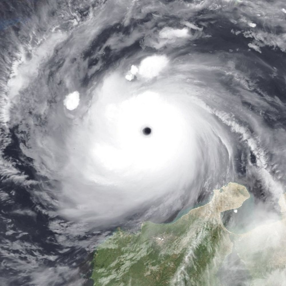
According to my analysis Intense Tropical Cyclone Gezani has just made landfall, unfortunately pretty much right on top of the port city of Toamasina. Satellite estimates suggest Gezani was a C4 SSHWS with winds of ~220 km/h at landfall. The reasonable worst case has sadly come true.
10.02.2026 17:11 —
👍 0
🔁 0
💬 0
📌 0
According to my analysis Intense Tropical Cyclone Gezani has just made landfall unfortunately virtually on top of the port city of Toamasina. Satellite estimates suggest Gezani was a Cat 4 SSHWS with winds of ~220 km/h at landfall. The reasonable worst case has sadly come true.
10.02.2026 17:08 —
👍 0
🔁 0
💬 0
📌 0