The cluster of strong cells in Stephens Passage weakened. Skies
will continue to clear through this evening with decreasing wind
speeds through the overnight.
Around 520PM local time, the cluster of strong showers were near
Dixon Entrance moving east towards Canada. Storms are weakening
and will continue to weaken with quieter skies expected overnight.
Marine Weather Statement issued August 3 at 5:24PM AKDT by NWS Juneau AK
Additional Details Here.
04.08.2025 01:30 — 👍 1 🔁 0 💬 0 📌 0
Around 445PM local time, a cluster of strong showers were
near Dixon Entrance moving E/NE. Some lightning has been detected
from these cells. At this time, expect heavier rain reducing
visibility to less than 3 miles, along with erratic/gusty winds of
up to 20 to 30 knots.
Marine Weather Statement issued August 3 at 4:47PM AKDT by NWS Juneau AK
Additional Details Here.
04.08.2025 01:00 — 👍 0 🔁 0 💬 0 📌 0

The cluster of stronger cells in Stephens Passage have
weakened.
Near 3pm local time a cluster of strong showers were crossing
Dixon Entrance from Rose Point, moving towards Revillagigedo
Channel. Expect heavy rain reducing visibility less than 3 miles,
along with erratic/gusty winds of 20 to 30 knots.
Marine Weather Statement issued August 3 at 3:01PM AKDT by NWS Juneau AK
Additional Details Here.
03.08.2025 23:15 — 👍 1 🔁 0 💬 0 📌 0
A cluster of enhanced showers are currently moving into Stephens
Passage, with cameras reporting isolated heavy rainfall and
reduced visibility. These storms will continue to move north
Sunday afternoon, potentially into Gastineau Channel by 230pm,
bringing heavy rainfall and potential for gusty/erratic winds of
20 to 30 knots. Stay tuned to the NOAA weather radio or
weather.gov/juneau for updates.
Marine Weather Statement issued August 3 at 12:13PM AKDT by NWS Juneau AK
Additional Details Here.
03.08.2025 20:15 — 👍 1 🔁 0 💬 0 📌 0
* WHAT...Visibility one quarter mile or less in dense fog.
* WHERE...Admiralty Island including Angoon, and Petersburg
Borough.
* WHEN...Until 8 AM AKDT this morning.
* IMPACTS...Hazardous travel conditions due to low visibility.
Dense Fog Advisory issued August 2 at 5:01AM AKDT until August 2 at 8:00AM AKDT by NWS Juneau AK
Additional Details Here.
02.08.2025 13:15 — 👍 1 🔁 0 💬 0 📌 0
An incoming front will move from south to north through the
morning hours, bringing short duration 20 knot winds with near
gale gusts. Expect to see the front reach Point Gardner by
midnight tonight, Point Coverden by 4 AM, and northern Lynn Canal
by 6 AM.
Marine Weather Statement issued July 31 at 10:03PM AKDT by NWS Juneau AK
Additional Details Here.
01.08.2025 06:15 — 👍 1 🔁 0 💬 0 📌 0
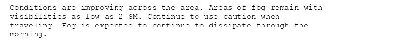
Conditions are improving across the area. Areas of fog remain with
visibilities as low as 2 SM. Continue to use caution when
traveling. Fog is expected to continue to dissipate through the
morning.
Dense Fog Advisory issued July 31 at 9:40AM AKDT until July 31 at 10:00AM AKDT by NWS Juneau AK
Additional Details Here.
31.07.2025 17:45 — 👍 2 🔁 0 💬 0 📌 0
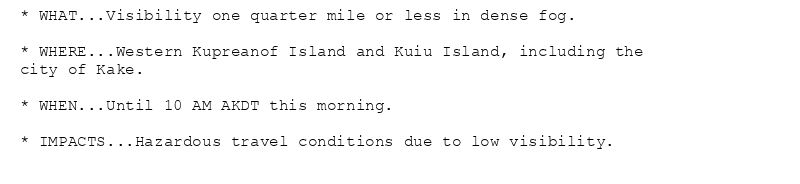
* WHAT...Visibility one quarter mile or less in dense fog.
* WHERE...Western Kupreanof Island and Kuiu Island, including the
city of Kake.
* WHEN...Until 10 AM AKDT this morning.
* IMPACTS...Hazardous travel conditions due to low visibility.
Dense Fog Advisory issued July 31 at 7:48AM AKDT until July 31 at 10:00AM AKDT by NWS Juneau AK
Additional Details Here.
31.07.2025 16:00 — 👍 1 🔁 0 💬 0 📌 0
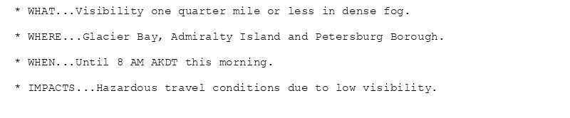
* WHAT...Visibility one quarter mile or less in dense fog.
* WHERE...Glacier Bay, Admiralty Island and Petersburg Borough.
* WHEN...Until 8 AM AKDT this morning.
* IMPACTS...Hazardous travel conditions due to low visibility.
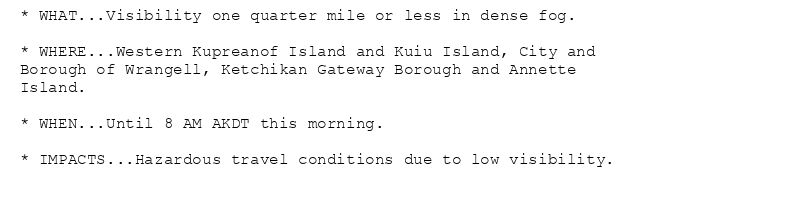
* WHAT...Visibility one quarter mile or less in dense fog.
* WHERE...Western Kupreanof Island and Kuiu Island, City and
Borough of Wrangell, Ketchikan Gateway Borough and Annette
Island.
* WHEN...Until 8 AM AKDT this morning.
* IMPACTS...Hazardous travel conditions due to low visibility.
Dense Fog Advisory issued July 31 at 4:18AM AKDT until July 31 at 8:00AM AKDT by NWS Juneau AK
Additional Details Here.
31.07.2025 12:30 — 👍 1 🔁 0 💬 0 📌 0
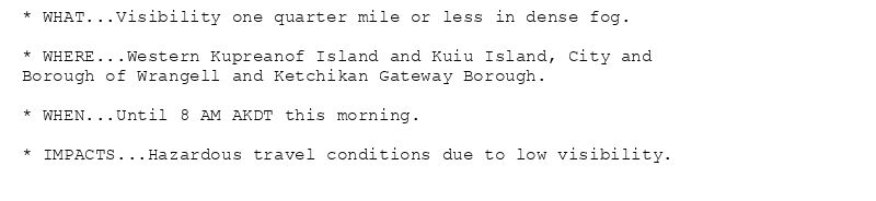
* WHAT...Visibility one quarter mile or less in dense fog.
* WHERE...Western Kupreanof Island and Kuiu Island, City and
Borough of Wrangell and Ketchikan Gateway Borough.
* WHEN...Until 8 AM AKDT this morning.
* IMPACTS...Hazardous travel conditions due to low visibility.
* WHAT...Visibility one quarter mile or less in dense fog.
* WHERE...Annette Island.
* WHEN...Until 8 AM AKDT this morning.
* IMPACTS...Hazardous travel conditions due to low visibility.
Dense Fog Advisory issued July 31 at 3:09AM AKDT until July 31 at 8:00AM AKDT by NWS Juneau AK
Additional Details Here.
31.07.2025 11:15 — 👍 1 🔁 0 💬 0 📌 0
* WHAT...Visibility one quarter mile or less in dense fog.
* WHERE...Annette Island.
* WHEN...Until 8 AM AKDT this morning.
* IMPACTS...Hazardous travel conditions due to low visibility.
Dense Fog Advisory issued July 31 at 12:27AM AKDT until July 31 at 8:00AM AKDT by NWS Juneau AK
Additional Details Here.
31.07.2025 08:30 — 👍 1 🔁 0 💬 0 📌 0

Several areas did hit 80 or higher today. Temperatures are
starting to cooling off this evening.
Heat Advisory issued July 28 at 7:32PM AKDT until July 28 at 8:00PM AKDT by NWS Juneau AK
Additional Details Here.
29.07.2025 04:52 — 👍 1 🔁 0 💬 0 📌 0
Southeast Alaska Coastal Waters from Dixon Entrance to
Cape Suckling out 100 NM
Wind forecasts reflect the predominant speed and direction
expected. Seas forecasts represent the average of the highest
one-third of the combined windwave and swell height.
.TONIGHT...E wind 25 kt becoming SE 20 kt. Seas 8 ft. Rain early
in the evening.
.TUE...SE wind 20 kt. Seas 7 ft.
.TUE NIGHT...SE wind 15 kt becoming S 10 kt late. Seas 5 ft.
.WED...SE wind 15 kt. Seas 4 ft.
.WED NIGHT...SE wind 10 kt. Seas 4 ft.
.THU...SE wind 15 kt. Seas 4 ft.
.FRI...S wind 15 kt. Seas 5 ft.
.SAT...SE wind 15 kt. Seas 5 ft.
Southeast Alaska Coastal Waters from Dixon Entrance to
Cape Suckling out 100 NM
Wind forecasts reflect the predominant speed and direction
expected. Seas forecasts represent the average of the highest
one-third of the combined windwave and swell height.
.TONIGHT...SE wind 20 kt. Seas 7 ft building to 8 ft. Rain early
in the evening.
.TUE...SE wind 20 kt diminishing to 15 kt in the afternoon.
Seas 7 ft.
.TUE NIGHT...SE wind 15 kt diminishing to 10 kt late. Seas
6 ft.
.WED...SE wind 15 kt. Seas 4 ft.
.WED NIGHT...SE wind 10 kt. Seas 4 ft.
.THU...SE wind 15 kt. Seas 4 ft.
.FRI...SE wind 15 kt. Seas 5 ft.
.SAT...SE wind 15 kt. Seas 5 ft.
Small Craft Advisory issued July 28 at 5:10PM AKDT until July 29 at 5:00AM AKDT by NWS Juneau AK
Additional Details Here.
29.07.2025 02:21 — 👍 1 🔁 0 💬 0 📌 0
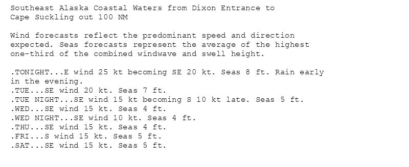
Southeast Alaska Coastal Waters from Dixon Entrance to
Cape Suckling out 100 NM
Wind forecasts reflect the predominant speed and direction
expected. Seas forecasts represent the average of the highest
one-third of the combined windwave and swell height.
.TONIGHT...E wind 25 kt becoming SE 20 kt. Seas 8 ft. Rain early
in the evening.
.TUE...SE wind 20 kt. Seas 7 ft.
.TUE NIGHT...SE wind 15 kt becoming S 10 kt late. Seas 5 ft.
.WED...SE wind 15 kt. Seas 4 ft.
.WED NIGHT...SE wind 10 kt. Seas 4 ft.
.THU...SE wind 15 kt. Seas 4 ft.
.FRI...S wind 15 kt. Seas 5 ft.
.SAT...SE wind 15 kt. Seas 5 ft.
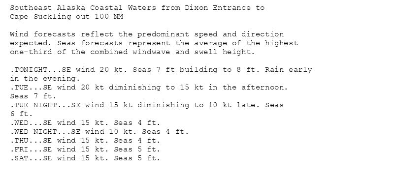
Southeast Alaska Coastal Waters from Dixon Entrance to
Cape Suckling out 100 NM
Wind forecasts reflect the predominant speed and direction
expected. Seas forecasts represent the average of the highest
one-third of the combined windwave and swell height.
.TONIGHT...SE wind 20 kt. Seas 7 ft building to 8 ft. Rain early
in the evening.
.TUE...SE wind 20 kt diminishing to 15 kt in the afternoon.
Seas 7 ft.
.TUE NIGHT...SE wind 15 kt diminishing to 10 kt late. Seas
6 ft.
.WED...SE wind 15 kt. Seas 4 ft.
.WED NIGHT...SE wind 10 kt. Seas 4 ft.
.THU...SE wind 15 kt. Seas 4 ft.
.FRI...SE wind 15 kt. Seas 5 ft.
.SAT...SE wind 15 kt. Seas 5 ft.
Small Craft Advisory issued July 28 at 2:45PM AKDT until July 29 at 5:00PM AKDT by NWS Juneau AK
Additional Details Here.
28.07.2025 23:04 — 👍 1 🔁 0 💬 0 📌 0
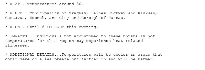
* WHAT...Temperatures around 80.
* WHERE...Municipality of Skagway, Haines Highway and Klukwan,
Gustavus, Hoonah, and City and Borough of Juneau.
* WHEN...Until 8 PM AKDT this evening.
* IMPACTS...Individuals not accustomed to these unusually hot
temperatures for this region may experience heat related
illnesses.
* ADDITIONAL DETAILS...Temperatures will be cooler in areas that
could develop a sea breeze but farther inland will be warmer.
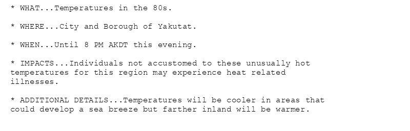
* WHAT...Temperatures in the 80s.
* WHERE...City and Borough of Yakutat.
* WHEN...Until 8 PM AKDT this evening.
* IMPACTS...Individuals not accustomed to these unusually hot
temperatures for this region may experience heat related
illnesses.
* ADDITIONAL DETAILS...Temperatures will be cooler in areas that
could develop a sea breeze but farther inland will be warmer.
Heat Advisory issued July 28 at 11:43AM AKDT until July 28 at 8:00PM AKDT by NWS Juneau AK
Additional Details Here.
28.07.2025 21:00 — 👍 0 🔁 0 💬 0 📌 0
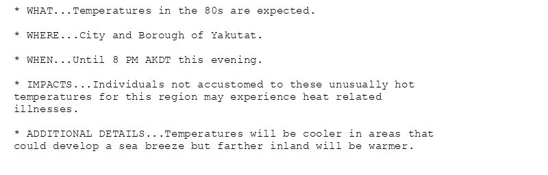
* WHAT...Temperatures in the 80s are expected.
* WHERE...City and Borough of Yakutat.
* WHEN...Until 8 PM AKDT this evening.
* IMPACTS...Individuals not accustomed to these unusually hot
temperatures for this region may experience heat related
illnesses.
* ADDITIONAL DETAILS...Temperatures will be cooler in areas that
could develop a sea breeze but farther inland will be warmer.
Heat Advisory issued July 28 at 11:05AM AKDT until July 28 at 8:00PM AKDT by NWS Juneau AK
Additional Details Here.
28.07.2025 19:58 — 👍 1 🔁 0 💬 0 📌 0
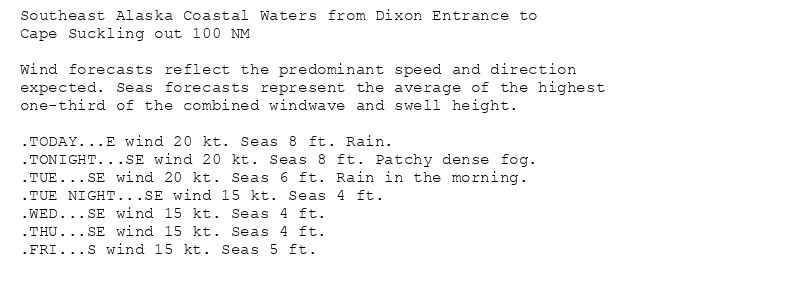
Southeast Alaska Coastal Waters from Dixon Entrance to
Cape Suckling out 100 NM
Wind forecasts reflect the predominant speed and direction
expected. Seas forecasts represent the average of the highest
one-third of the combined windwave and swell height.
.TODAY...E wind 20 kt. Seas 8 ft. Rain.
.TONIGHT...SE wind 20 kt. Seas 8 ft. Patchy dense fog.
.TUE...SE wind 20 kt. Seas 6 ft. Rain in the morning.
.TUE NIGHT...SE wind 15 kt. Seas 4 ft.
.WED...SE wind 15 kt. Seas 4 ft.
.THU...SE wind 15 kt. Seas 4 ft.
.FRI...S wind 15 kt. Seas 5 ft.
Small Craft Advisory issued July 28 at 3:23AM AKDT until July 29 at 5:00AM AKDT by NWS Juneau AK
Additional Details Here.
28.07.2025 12:13 — 👍 0 🔁 0 💬 0 📌 0
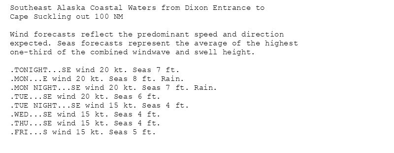
Southeast Alaska Coastal Waters from Dixon Entrance to
Cape Suckling out 100 NM
Wind forecasts reflect the predominant speed and direction
expected. Seas forecasts represent the average of the highest
one-third of the combined windwave and swell height.
.TONIGHT...SE wind 20 kt. Seas 7 ft.
.MON...E wind 20 kt. Seas 8 ft. Rain.
.MON NIGHT...SE wind 20 kt. Seas 7 ft. Rain.
.TUE...SE wind 20 kt. Seas 6 ft.
.TUE NIGHT...SE wind 15 kt. Seas 4 ft.
.WED...SE wind 15 kt. Seas 4 ft.
.THU...SE wind 15 kt. Seas 4 ft.
.FRI...S wind 15 kt. Seas 5 ft.
Small Craft Advisory issued July 27 at 5:25PM AKDT until July 28 at 5:00PM AKDT by NWS Juneau AK
Additional Details Here.
28.07.2025 01:58 — 👍 0 🔁 0 💬 0 📌 0
Southeast Alaska Coastal Waters from Dixon Entrance to
Cape Suckling out 100 NM
Wind forecasts reflect the predominant speed and direction
expected. Seas forecasts represent the average of the highest
one-third of the combined windwave and swell height.
.TONIGHT...SE wind 20 kt. Seas 7 ft.
.MON...E wind 20 kt. Seas 8 ft. Rain.
.MON NIGHT...SE wind 20 kt. Seas 7 ft. Rain.
.TUE...SE wind 20 kt. Seas 6 ft.
.TUE NIGHT...SE wind 15 kt. Seas 4 ft.
.WED...SE wind 15 kt. Seas 4 ft.
.THU...SE wind 15 kt. Seas 4 ft.
.FRI...S wind 15 kt. Seas 5 ft.
Small Craft Advisory issued July 27 at 2:34PM AKDT until July 28 at 5:00PM AKDT by NWS Juneau AK
Additional Details Here.
27.07.2025 23:08 — 👍 0 🔁 0 💬 0 📌 0
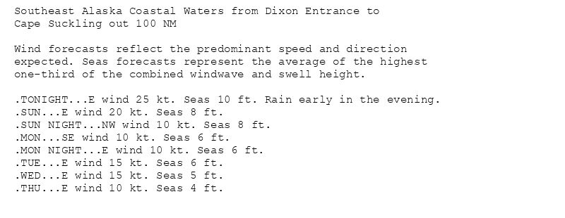
Southeast Alaska Coastal Waters from Dixon Entrance to
Cape Suckling out 100 NM
Wind forecasts reflect the predominant speed and direction
expected. Seas forecasts represent the average of the highest
one-third of the combined windwave and swell height.
.TONIGHT...E wind 25 kt. Seas 10 ft. Rain early in the evening.
.SUN...E wind 20 kt. Seas 8 ft.
.SUN NIGHT...NW wind 10 kt. Seas 8 ft.
.MON...SE wind 10 kt. Seas 6 ft.
.MON NIGHT...E wind 10 kt. Seas 6 ft.
.TUE...E wind 15 kt. Seas 6 ft.
.WED...E wind 15 kt. Seas 5 ft.
.THU...E wind 10 kt. Seas 4 ft.
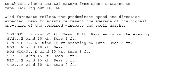
Southeast Alaska Coastal Waters from Dixon Entrance to
Cape Suckling out 100 NM
Wind forecasts reflect the predominant speed and direction
expected. Seas forecasts represent the average of the highest
one-third of the combined windwave and swell height.
.TONIGHT...E wind 25 kt. Seas 10 ft. Rain early in the evening.
.SUN...E wind 20 kt. Seas 8 ft.
.SUN NIGHT...NE wind 15 kt becoming NW late. Seas 8 ft.
.MON...N wind 10 kt. Seas 6 ft.
.MON NIGHT...E wind 10 kt. Seas 6 ft.
.TUE...E wind 15 kt. Seas 6 ft.
.WED...E wind 15 kt. Seas 5 ft.
.THU...E wind 10 kt. Seas 4 ft.
Small Craft Advisory issued July 26 at 2:53PM AKDT until July 27 at 5:00PM AKDT by NWS Juneau AK
Additional Details Here.(2/2)
26.07.2025 23:01 — 👍 0 🔁 0 💬 0 📌 0
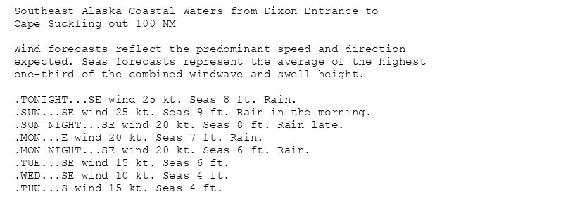
Southeast Alaska Coastal Waters from Dixon Entrance to
Cape Suckling out 100 NM
Wind forecasts reflect the predominant speed and direction
expected. Seas forecasts represent the average of the highest
one-third of the combined windwave and swell height.
.TONIGHT...SE wind 25 kt. Seas 8 ft. Rain.
.SUN...SE wind 25 kt. Seas 9 ft. Rain in the morning.
.SUN NIGHT...SE wind 20 kt. Seas 8 ft. Rain late.
.MON...E wind 20 kt. Seas 7 ft. Rain.
.MON NIGHT...SE wind 20 kt. Seas 6 ft. Rain.
.TUE...SE wind 15 kt. Seas 6 ft.
.WED...SE wind 10 kt. Seas 4 ft.
.THU...S wind 15 kt. Seas 4 ft.
Southeast Alaska Coastal Waters from Dixon Entrance to
Cape Suckling out 100 NM
Wind forecasts reflect the predominant speed and direction
expected. Seas forecasts represent the average of the highest
one-third of the combined windwave and swell height.
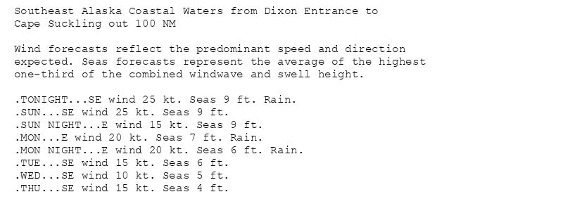
.TONIGHT...SE wind 25 kt. Seas 9 ft. Rain.
.SUN...SE wind 25 kt. Seas 9 ft.
.SUN NIGHT...E wind 15 kt. Seas 9 ft.
.MON...E wind 20 kt. Seas 7 ft. Rain.
.MON NIGHT...E wind 20 kt. Seas 6 ft. Rain.
.TUE...SE wind 15 kt. Seas 6 ft.
.WED...SE wind 10 kt. Seas 5 ft.
.THU...SE wind 15 kt. Seas 4 ft.

Southeast Alaska Coastal Waters from Dixon Entrance to
Cape Suckling out 100 NM
Wind forecasts reflect the predominant speed and direction
expected. Seas forecasts represent the average of the highest
one-third of the combined windwave and swell height.
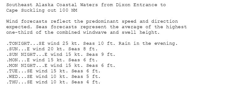
.TONIGHT...SE wind 25 kt. Seas 9 ft. Rain in the evening.
.SUN...E wind 25 kt. Seas 9 ft.
.SUN NIGHT...E wind 15 kt. Seas 9 ft.
.MON...E wind 15 kt. Seas 6 ft.
.MON NIGHT...E wind 15 kt. Seas 6 ft. Rain.
.TUE...SE wind 15 kt. Seas 6 ft.
.WED...SE wind 10 kt. Seas 5 ft.
.THU...SE wind 15 kt. Seas 4 ft.
Southeast Alaska Coastal Waters from Dixon Entrance to
Cape Suckling out 100 NM
Wind forecasts reflect the predominant speed and direction
expected. Seas forecasts represent the average of the highest
one-third of the combined windwave and swell height.
.TONIGHT...SE wind 25 kt. Seas 10 ft. Rain in the evening.
.SUN...E wind 20 kt. Seas 8 ft.
.SUN NIGHT...E wind 15 kt. Seas 9 ft.
.MON...E wind 15 kt. Seas 6 ft.
.MON NIGHT...E wind 15 kt. Seas 6 ft.
.TUE...SE wind 15 kt. Seas 6 ft.
.WED...SE wind 10 kt. Seas 5 ft.
.THU...SE wind 10 kt. Seas 4 ft.
Small Craft Advisory issued July 26 at 2:53PM AKDT until July 27 at 5:00PM AKDT by NWS Juneau AK
Additional Details Here.
(1/2)
26.07.2025 23:00 — 👍 0 🔁 0 💬 0 📌 0
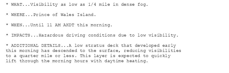
* WHAT...Visibility as low as 1/4 mile in dense fog.
* WHERE...Prince of Wales Island.
* WHEN...Until 11 AM AKDT this morning.
* IMPACTS...Hazardous driving conditions due to low visibility.
* ADDITIONAL DETAILS...A low stratus deck that developed early
this morning has descended to the surface, reducing visibilities
to a quarter mile or less. This layer is expected to quickly
lift through the morning hours with daytime heating.
Dense Fog Advisory issued July 26 at 6:57AM AKDT until July 26 at 11:00AM AKDT by NWS Juneau AK
Additional Details Here.
26.07.2025 15:52 — 👍 0 🔁 0 💬 0 📌 0
Southeast Alaska Coastal Waters from Dixon Entrance to
Cape Suckling out 100 NM
Wind forecasts reflect the predominant speed and direction
expected. Seas forecasts represent the average of the highest
one-third of the combined windwave and swell height.
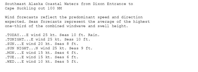
.TODAY...E wind 25 kt. Seas 10 ft. Rain.
.TONIGHT...E wind 25 kt. Seas 10 ft.
.SUN...E wind 20 kt. Seas 8 ft.
.SUN NIGHT...N wind 25 kt. Seas 9 ft.
.MON...E wind 15 kt. Seas 6 ft.
.TUE...E wind 15 kt. Seas 6 ft.
.WED...E wind 10 kt. Seas 5 ft.
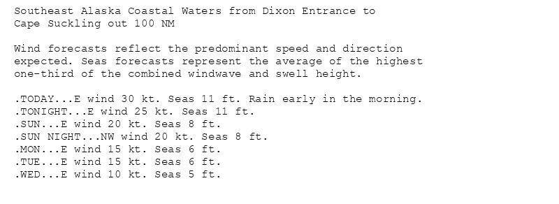
Southeast Alaska Coastal Waters from Dixon Entrance to
Cape Suckling out 100 NM
Wind forecasts reflect the predominant speed and direction
expected. Seas forecasts represent the average of the highest
one-third of the combined windwave and swell height.
.TODAY...E wind 30 kt. Seas 11 ft. Rain early in the morning.
.TONIGHT...E wind 25 kt. Seas 11 ft.
.SUN...E wind 20 kt. Seas 8 ft.
.SUN NIGHT...NW wind 20 kt. Seas 8 ft.
.MON...E wind 15 kt. Seas 6 ft.
.TUE...E wind 15 kt. Seas 6 ft.
.WED...E wind 10 kt. Seas 5 ft.
Small Craft Advisory issued July 26 at 4:10AM AKDT until July 27 at 5:00PM AKDT by NWS Juneau AK
Additional Details Here.(2/2)
26.07.2025 12:56 — 👍 0 🔁 0 💬 0 📌 0
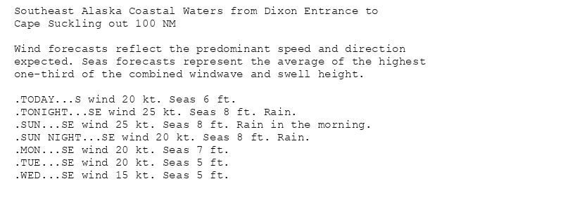
Southeast Alaska Coastal Waters from Dixon Entrance to
Cape Suckling out 100 NM
Wind forecasts reflect the predominant speed and direction
expected. Seas forecasts represent the average of the highest
one-third of the combined windwave and swell height.
.TODAY...S wind 20 kt. Seas 6 ft.
.TONIGHT...SE wind 25 kt. Seas 8 ft. Rain.
.SUN...SE wind 25 kt. Seas 8 ft. Rain in the morning.
.SUN NIGHT...SE wind 20 kt. Seas 8 ft. Rain.
.MON...SE wind 20 kt. Seas 7 ft.
.TUE...SE wind 20 kt. Seas 5 ft.
.WED...SE wind 15 kt. Seas 5 ft.
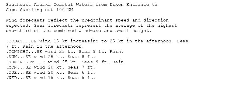
Southeast Alaska Coastal Waters from Dixon Entrance to
Cape Suckling out 100 NM
Wind forecasts reflect the predominant speed and direction
expected. Seas forecasts represent the average of the highest
one-third of the combined windwave and swell height.
.TODAY...SE wind 15 kt increasing to 25 kt in the afternoon. Seas
7 ft. Rain in the afternoon.
.TONIGHT...SE wind 25 kt. Seas 9 ft. Rain.
.SUN...SE wind 25 kt. Seas 8 ft.
.SUN NIGHT...E wind 25 kt. Seas 9 ft. Rain.
.MON...SE wind 20 kt. Seas 7 ft.
.TUE...SE wind 20 kt. Seas 6 ft.
.WED...SE wind 15 kt. Seas 5 ft.
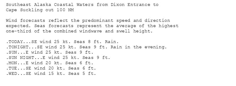
Southeast Alaska Coastal Waters from Dixon Entrance to
Cape Suckling out 100 NM
Wind forecasts reflect the predominant speed and direction
expected. Seas forecasts represent the average of the highest
one-third of the combined windwave and swell height.
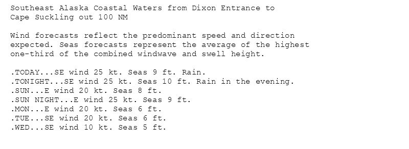
.TODAY...SE wind 25 kt. Seas 8 ft. Rain.
.TONIGHT...SE wind 25 kt. Seas 9 ft. Rain in the evening.
.SUN...E wind 25 kt. Seas 9 ft.
.SUN NIGHT...E wind 25 kt. Seas 9 ft.
.MON...E wind 20 kt. Seas 6 ft.
.TUE...SE wind 20 kt. Seas 6 ft.
.WED...SE wind 15 kt. Seas 5 ft.
Southeast Alaska Coastal Waters from Dixon Entrance to
Cape Suckling out 100 NM
Wind forecasts reflect the predominant speed and direction
expected. Seas forecasts represent the average of the highest
one-third of the combined windwave and swell height.
.TODAY...SE wind 25 kt. Seas 9 ft. Rain.
.TONIGHT...SE wind 25 kt. Seas 10 ft. Rain in the evening.
.SUN...E wind 20 kt. Seas 8 ft.
.SUN NIGHT...E wind 25 kt. Seas 9 ft.
.MON...E wind 20 kt. Seas 6 ft.
.TUE...SE wind 20 kt. Seas 6 ft.
.WED...SE wind 10 kt. Seas 5 ft.
Small Craft Advisory issued July 26 at 4:10AM AKDT until July 27 at 5:00PM AKDT by NWS Juneau AK
Additional Details Here.
(1/2)
26.07.2025 12:56 — 👍 0 🔁 0 💬 0 📌 0
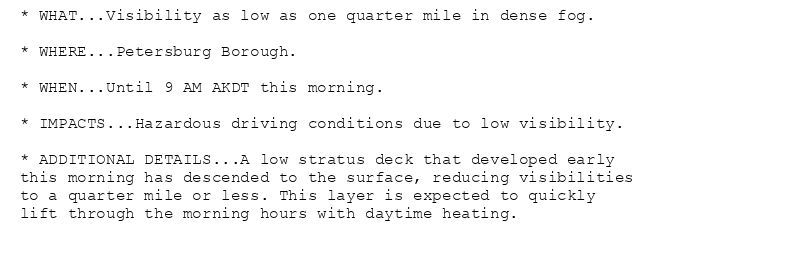
* WHAT...Visibility as low as one quarter mile in dense fog.
* WHERE...Petersburg Borough.
* WHEN...Until 9 AM AKDT this morning.
* IMPACTS...Hazardous driving conditions due to low visibility.
* ADDITIONAL DETAILS...A low stratus deck that developed early
this morning has descended to the surface, reducing visibilities
to a quarter mile or less. This layer is expected to quickly
lift through the morning hours with daytime heating.
Dense Fog Advisory issued July 26 at 3:15AM AKDT until July 26 at 9:00AM AKDT by NWS Juneau AK
Additional Details Here.
26.07.2025 12:20 — 👍 0 🔁 0 💬 0 📌 0
Southeast Alaska Coastal Waters from Dixon Entrance to
Cape Suckling out 100 NM
Wind forecasts reflect the predominant speed and direction
expected. Seas forecasts represent the average of the highest
one-third of the combined windwave and swell height.
.TONIGHT...SE wind 15 kt. Seas 6 ft.
.SAT...SE wind 30 kt. Seas 11 ft. Rain.
.SAT NIGHT...E wind 25 kt. Seas 11 ft. Rain.
.SUN...E wind 25 kt. Seas 9 ft.
.SUN NIGHT...E wind 25 kt. Seas 9 ft.
.MON...E wind 20 kt. Seas 6 ft.
.TUE...SE wind 20 kt. Seas 6 ft.
.WED...E wind 15 kt. Seas 5 ft.
Southeast Alaska Coastal Waters from Dixon Entrance to
Cape Suckling out 100 NM
Wind forecasts reflect the predominant speed and direction
expected. Seas forecasts represent the average of the highest
one-third of the combined windwave and swell height.
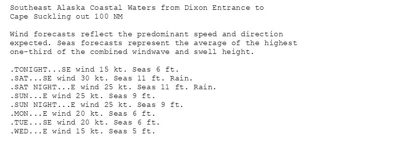
.TONIGHT...SE wind 20 kt. Seas 6 ft. Rain late.
.SAT...SE wind 30 kt. Seas 12 ft. Rain.
.SAT NIGHT...E wind 30 kt. Seas 11 ft. Rain in the evening.
.SUN...E wind 25 kt. Seas 9 ft.
.SUN NIGHT...N wind 25 kt. Seas 9 ft.
.MON...E wind 15 kt. Seas 6 ft.
.TUE...E wind 15 kt. Seas 6 ft.
.WED...E wind 15 kt. Seas 5 ft.
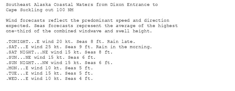
Southeast Alaska Coastal Waters from Dixon Entrance to
Cape Suckling out 100 NM
Wind forecasts reflect the predominant speed and direction
expected. Seas forecasts represent the average of the highest
one-third of the combined windwave and swell height.
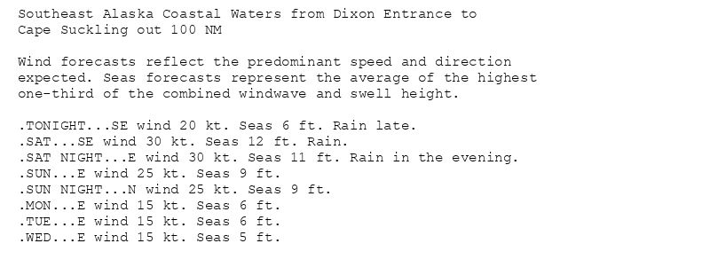
.TONIGHT...E wind 20 kt. Seas 8 ft. Rain late.
.SAT...E wind 25 kt. Seas 9 ft. Rain in the morning.
.SAT NIGHT...NE wind 15 kt. Seas 8 ft.
.SUN...NE wind 15 kt. Seas 6 ft.
.SUN NIGHT...NW wind 15 kt. Seas 6 ft.
.MON...E wind 10 kt. Seas 5 ft.
.TUE...E wind 15 kt. Seas 5 ft.
.WED...E wind 10 kt. Seas 4 ft.
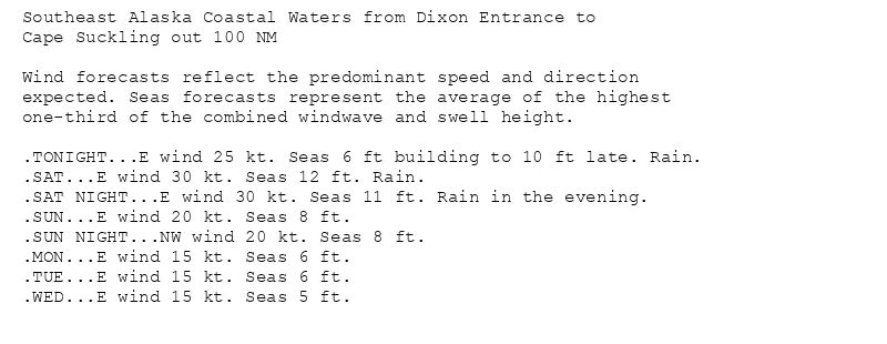
Southeast Alaska Coastal Waters from Dixon Entrance to
Cape Suckling out 100 NM
Wind forecasts reflect the predominant speed and direction
expected. Seas forecasts represent the average of the highest
one-third of the combined windwave and swell height.
.TONIGHT...E wind 25 kt. Seas 6 ft building to 10 ft late. Rain.
.SAT...E wind 30 kt. Seas 12 ft. Rain.
.SAT NIGHT...E wind 30 kt. Seas 11 ft. Rain in the evening.
.SUN...E wind 20 kt. Seas 8 ft.
.SUN NIGHT...NW wind 20 kt. Seas 8 ft.
.MON...E wind 15 kt. Seas 6 ft.
.TUE...E wind 15 kt. Seas 6 ft.
.WED...E wind 15 kt. Seas 5 ft.
Small Craft Advisory issued July 25 at 2:16PM AKDT until July 26 at 5:00PM AKDT by NWS Juneau AK
Additional Details Here.(2/3)
25.07.2025 22:35 — 👍 0 🔁 0 💬 0 📌 0
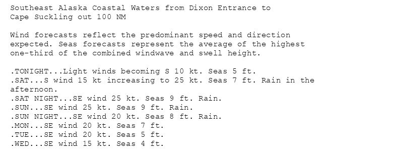
Southeast Alaska Coastal Waters from Dixon Entrance to
Cape Suckling out 100 NM
Wind forecasts reflect the predominant speed and direction
expected. Seas forecasts represent the average of the highest
one-third of the combined windwave and swell height.
.TONIGHT...Light winds becoming S 10 kt. Seas 5 ft.
.SAT...S wind 15 kt increasing to 25 kt. Seas 7 ft. Rain in the
afternoon.
.SAT NIGHT...SE wind 25 kt. Seas 9 ft. Rain.
.SUN...SE wind 25 kt. Seas 9 ft. Rain.
.SUN NIGHT...SE wind 20 kt. Seas 8 ft. Rain.
.MON...SE wind 20 kt. Seas 7 ft.
.TUE...SE wind 20 kt. Seas 5 ft.
.WED...SE wind 15 kt. Seas 4 ft.
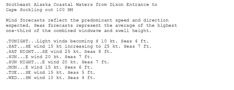
Southeast Alaska Coastal Waters from Dixon Entrance to
Cape Suckling out 100 NM
Wind forecasts reflect the predominant speed and direction
expected. Seas forecasts represent the average of the highest
one-third of the combined windwave and swell height.
.TONIGHT...Light winds becoming S 10 kt. Seas 4 ft.
.SAT...SE wind 15 kt increasing to 25 kt. Seas 7 ft.
.SAT NIGHT...SE wind 25 kt. Seas 8 ft.
.SUN...E wind 20 kt. Seas 7 ft.
.SUN NIGHT...E wind 20 kt. Seas 7 ft.
.MON...E wind 15 kt. Seas 6 ft.
.TUE...SE wind 15 kt. Seas 5 ft.
.WED...SW wind 10 kt. Seas 4 ft.
Southeast Alaska Coastal Waters from Dixon Entrance to
Cape Suckling out 100 NM
Wind forecasts reflect the predominant speed and direction
expected. Seas forecasts represent the average of the highest
one-third of the combined windwave and swell height.
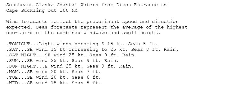
.TONIGHT...Light winds becoming S 15 kt. Seas 5 ft.
.SAT...SE wind 15 kt increasing to 25 kt. Seas 8 ft. Rain.
.SAT NIGHT...SE wind 25 kt. Seas 9 ft. Rain.
.SUN...SE wind 25 kt. Seas 9 ft. Rain.
.SUN NIGHT...E wind 25 kt. Seas 9 ft. Rain.
.MON...SE wind 20 kt. Seas 7 ft.
.TUE...SE wind 20 kt. Seas 6 ft.
.WED...SE wind 15 kt. Seas 5 ft.
Southeast Alaska Coastal Waters from Dixon Entrance to
Cape Suckling out 100 NM
Wind forecasts reflect the predominant speed and direction
expected. Seas forecasts represent the average of the highest
one-third of the combined windwave and swell height.
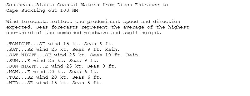
.TONIGHT...SE wind 15 kt. Seas 6 ft.
.SAT...SE wind 25 kt. Seas 9 ft. Rain.
.SAT NIGHT...SE wind 25 kt. Seas 10 ft. Rain.
.SUN...E wind 25 kt. Seas 9 ft.
.SUN NIGHT...E wind 25 kt. Seas 9 ft.
.MON...E wind 20 kt. Seas 6 ft.
.TUE...SE wind 20 kt. Seas 6 ft.
.WED...SE wind 15 kt. Seas 5 ft.
Small Craft Advisory issued July 25 at 2:16PM AKDT until July 26 at 5:00PM AKDT by NWS Juneau AK
Additional Details Here.
(1/3)
25.07.2025 22:35 — 👍 0 🔁 0 💬 0 📌 0
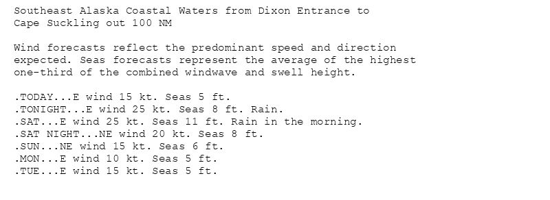
Southeast Alaska Coastal Waters from Dixon Entrance to
Cape Suckling out 100 NM
Wind forecasts reflect the predominant speed and direction
expected. Seas forecasts represent the average of the highest
one-third of the combined windwave and swell height.
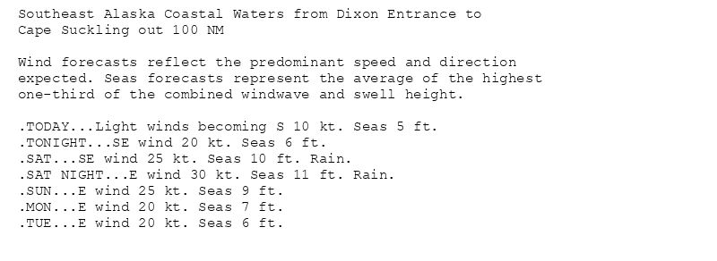
.TODAY...Light winds becoming S 10 kt. Seas 5 ft.
.TONIGHT...SE wind 20 kt. Seas 6 ft.
.SAT...SE wind 25 kt. Seas 10 ft. Rain.
.SAT NIGHT...E wind 30 kt. Seas 11 ft. Rain.
.SUN...E wind 25 kt. Seas 9 ft.
.MON...E wind 20 kt. Seas 7 ft.
.TUE...E wind 20 kt. Seas 6 ft.
Southeast Alaska Coastal Waters from Dixon Entrance to
Cape Suckling out 100 NM
Wind forecasts reflect the predominant speed and direction
expected. Seas forecasts represent the average of the highest
one-third of the combined windwave and swell height.
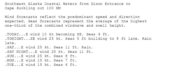
.TODAY...E wind 10 kt becoming SE. Seas 4 ft.
.TONIGHT...SE wind 25 kt. Seas 5 ft building to 8 ft late. Rain
late.
.SAT...E wind 25 kt. Seas 11 ft. Rain.
.SAT NIGHT...E wind 25 kt. Seas 11 ft.
.SUN...E wind 25 kt. Seas 8 ft.
.MON...E wind 15 kt. Seas 7 ft.
.TUE...E wind 15 kt. Seas 6 ft.
Southeast Alaska Coastal Waters from Dixon Entrance to
Cape Suckling out 100 NM
Wind forecasts reflect the predominant speed and direction
expected. Seas forecasts represent the average of the highest
one-third of the combined windwave and swell height.
.TODAY...E wind 15 kt. Seas 5 ft.
.TONIGHT...E wind 25 kt. Seas 8 ft. Rain.
.SAT...E wind 25 kt. Seas 11 ft. Rain in the morning.
.SAT NIGHT...NE wind 20 kt. Seas 8 ft.
.SUN...NE wind 15 kt. Seas 6 ft.
.MON...E wind 10 kt. Seas 5 ft.
.TUE...E wind 15 kt. Seas 5 ft.
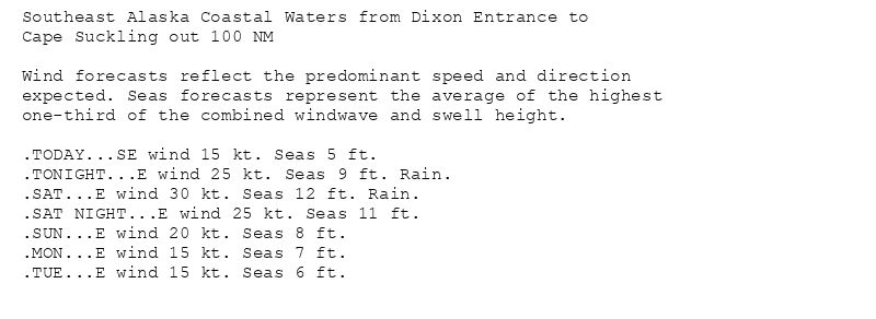
Southeast Alaska Coastal Waters from Dixon Entrance to
Cape Suckling out 100 NM
Wind forecasts reflect the predominant speed and direction
expected. Seas forecasts represent the average of the highest
one-third of the combined windwave and swell height.
.TODAY...SE wind 15 kt. Seas 5 ft.
.TONIGHT...E wind 25 kt. Seas 9 ft. Rain.
.SAT...E wind 30 kt. Seas 12 ft. Rain.
.SAT NIGHT...E wind 25 kt. Seas 11 ft.
.SUN...E wind 20 kt. Seas 8 ft.
.MON...E wind 15 kt. Seas 7 ft.
.TUE...E wind 15 kt. Seas 6 ft.
Small Craft Advisory issued July 25 at 4:03AM AKDT until July 26 at 5:00PM AKDT by NWS Juneau AK
Additional Details Here.(1/2)
25.07.2025 12:36 — 👍 0 🔁 0 💬 0 📌 0
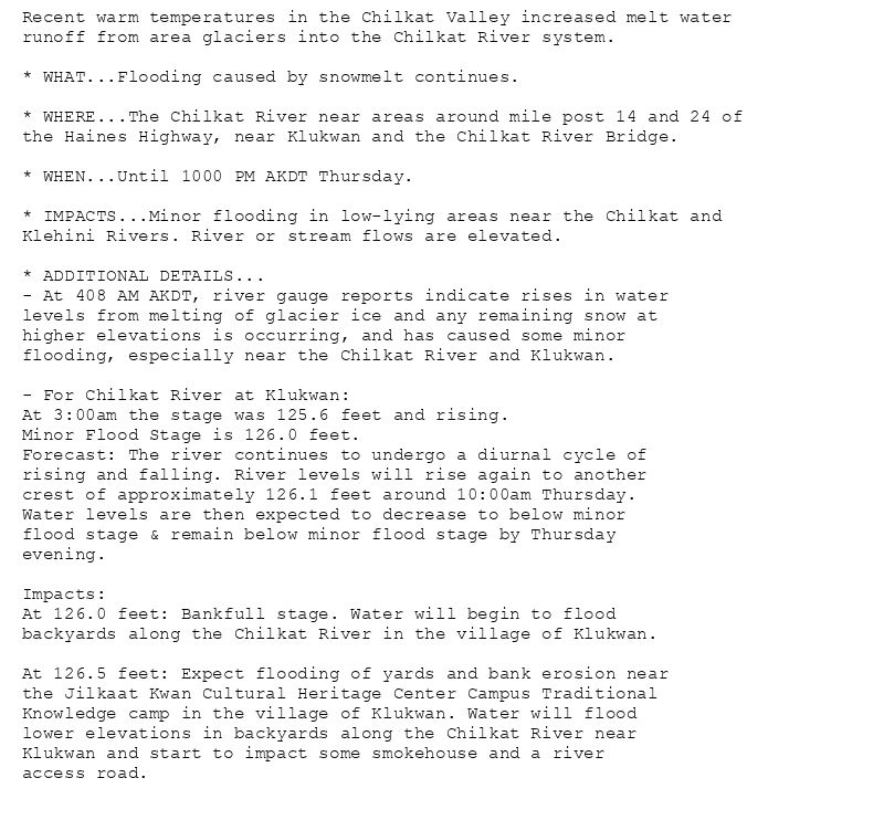
Recent warm temperatures in the Chilkat Valley increased melt water
runoff from area glaciers into the Chilkat River system.
* WHAT...Flooding caused by snowmelt continues.
* WHERE...The Chilkat River near areas around mile post 14 and 24 of
the Haines Highway, near Klukwan and the Chilkat River Bridge.
* WHEN...Until 1000 PM AKDT Thursday.
* IMPACTS...Minor flooding in low-lying areas near the Chilkat and
Klehini Rivers. River or stream flows are elevated.
* ADDITIONAL DETAILS...
- At 408 AM AKDT, river gauge reports indicate rises in water
levels from melting of glacier ice and any remaining snow at
higher elevations is occurring, and has caused some minor
flooding, especially near the Chilkat River and Klukwan.
- For Chilkat River at Klukwan:
At 3:00am the stage was 125.6 feet and rising.
Minor Flood Stage is 126.0 feet.
Forecast: The river continues to undergo a diurnal cycle of
rising and falling. River levels will rise again to another
crest of approximately 126.1 feet around 10:00am Thursday.
Water levels are then expected to decrease to below minor
flood stage & remain below minor flood stage by Thursday
evening.
Impacts:
At 126.0 feet: Bankfull stage. Water will begin to flood
backyards along the Chilkat River in the village of Klukwan.
At 126.5 feet: Expect flooding of yards and bank erosion near
the Jilkaat Kwan Cultural Heritage Center Campus Traditional
Knowledge camp in the village of Klukwan. Water will flood
lower elevations in backyards along the Chilkat River near
Klukwan and start to impact some smokehouse and a river
access road.
Flood Advisory issued July 24 at 4:19AM AKDT until July 24 at 10:00PM AKDT by NWS Juneau AK
Additional Details Here.
24.07.2025 12:32 — 👍 0 🔁 0 💬 0 📌 0
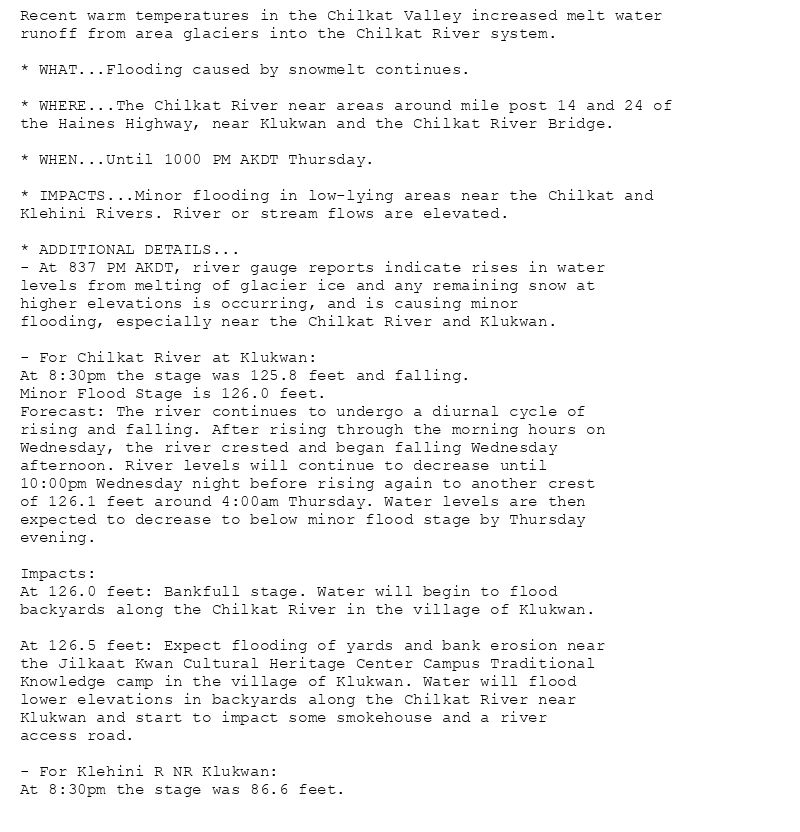
Recent warm temperatures in the Chilkat Valley increased melt water
runoff from area glaciers into the Chilkat River system.
* WHAT...Flooding caused by snowmelt continues.
* WHERE...The Chilkat River near areas around mile post 14 and 24 of
the Haines Highway, near Klukwan and the Chilkat River Bridge.
* WHEN...Until 1000 PM AKDT Thursday.
* IMPACTS...Minor flooding in low-lying areas near the Chilkat and
Klehini Rivers. River or stream flows are elevated.
* ADDITIONAL DETAILS...
- At 837 PM AKDT, river gauge reports indicate rises in water
levels from melting of glacier ice and any remaining snow at
higher elevations is occurring, and is causing minor
flooding, especially near the Chilkat River and Klukwan.
- For Chilkat River at Klukwan:
At 8:30pm the stage was 125.8 feet and falling.
Minor Flood Stage is 126.0 feet.
Forecast: The river continues to undergo a diurnal cycle of
rising and falling. After rising through the morning hours on
Wednesday, the river crested and began falling Wednesday
afternoon. River levels will continue to decrease until
10:00pm Wednesday night before rising again to another crest
of 126.1 feet around 4:00am Thursday. Water levels are then
expected to decrease to below minor flood stage by Thursday
evening.
Impacts:
At 126.0 feet: Bankfull stage. Water will begin to flood
backyards along the Chilkat River in the village of Klukwan.
At 126.5 feet: Expect flooding of yards and bank erosion near
the Jilkaat Kwan Cultural Heritage Center Campus Traditional
Knowledge camp in the village of Klukwan. Water will flood
lower elevations in backyards along the Chilkat River near
Klukwan and start to impact some smokehouse and a river
access road.
- For Klehini R NR Klukwan:
At 8:30pm the stage was 86.6 feet.
Flood Advisory issued July 23 at 8:38PM AKDT until July 24 at 10:00PM AKDT by NWS Juneau AK
Additional Details Here.
24.07.2025 05:01 — 👍 0 🔁 0 💬 0 📌 0