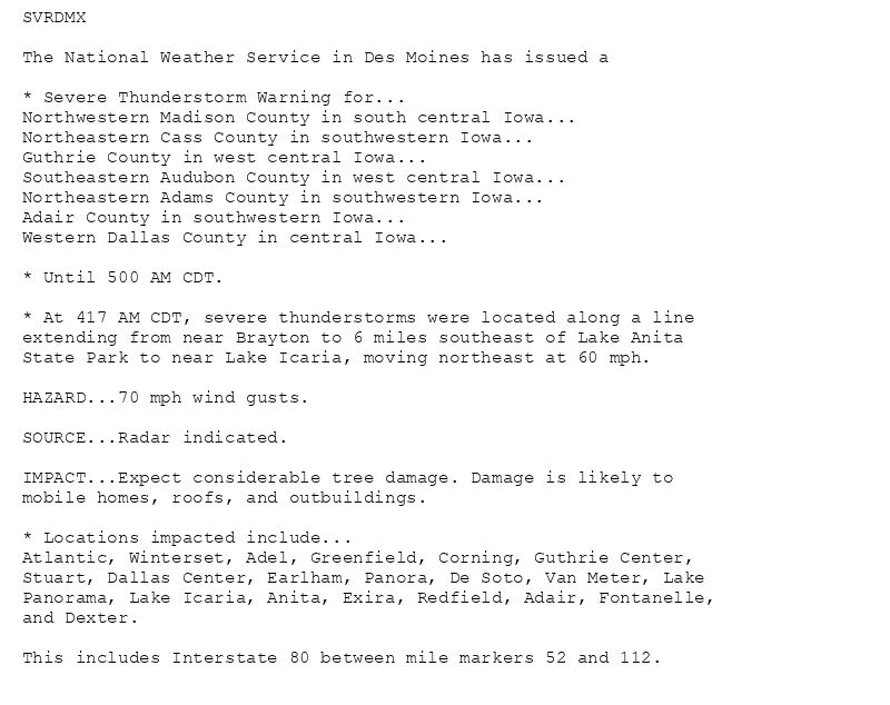
SVRDMX
The National Weather Service in Des Moines has issued a
* Severe Thunderstorm Warning for...
Northwestern Madison County in south central Iowa...
Northeastern Cass County in southwestern Iowa...
Guthrie County in west central Iowa...
Southeastern Audubon County in west central Iowa...
Northeastern Adams County in southwestern Iowa...
Adair County in southwestern Iowa...
Western Dallas County in central Iowa...
* Until 500 AM CDT.
* At 417 AM CDT, severe thunderstorms were located along a line
extending from near Brayton to 6 miles southeast of Lake Anita
State Park to near Lake Icaria, moving northeast at 60 mph.
HAZARD...70 mph wind gusts.
SOURCE...Radar indicated.
IMPACT...Expect considerable tree damage. Damage is likely to
mobile homes, roofs, and outbuildings.
* Locations impacted include...
Atlantic, Winterset, Adel, Greenfield, Corning, Guthrie Center,
Stuart, Dallas Center, Earlham, Panora, De Soto, Van Meter, Lake
Panorama, Lake Icaria, Anita, Exira, Redfield, Adair, Fontanelle,
and Dexter.
This includes Interstate 80 between mile markers 52 and 112.
🚨 Severe Thunderstorm Warning issued August 10 at 4:17AM CDT until August 10 at 5:00AM CDT by NWS Des Moines IA 🚨
Additional Details Here.
10.08.2025 09:30 — 👍 0 🔁 0 💬 0 📌 0
DMX issues Severe Thunderstorm Warning [damage threat: CONSIDERABLE, wind: 70 MPH (RADAR INDICATED), hail: <.75 IN (RADAR INDICATED)] for Adair, Adams, Audubon, Cass, Dallas, Gu... at Sun, 10 Aug 2025 09:17:52 +0000 via IEMbot
Additional Details Here.
10.08.2025 09:28 — 👍 0 🔁 0 💬 0 📌 0
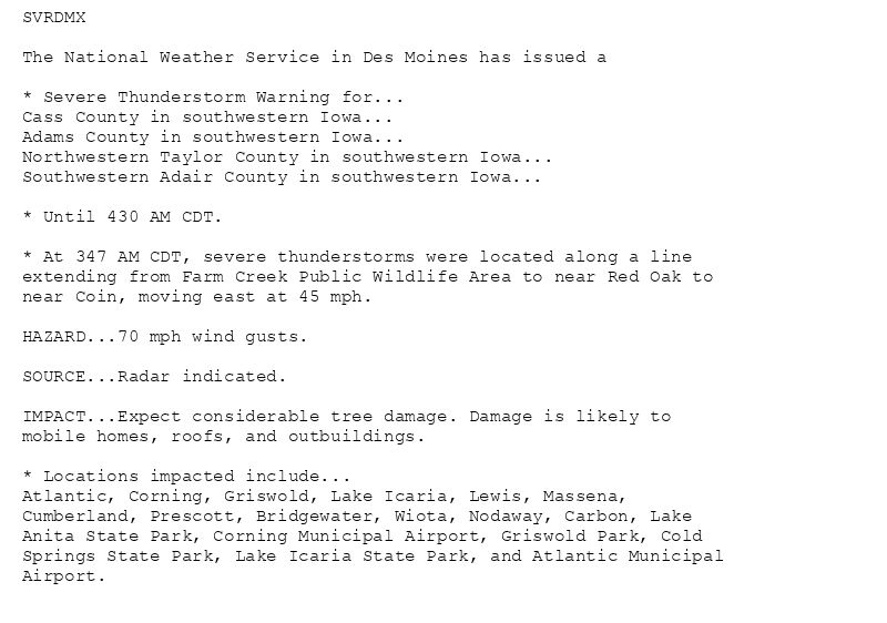
SVRDMX
The National Weather Service in Des Moines has issued a
* Severe Thunderstorm Warning for...
Cass County in southwestern Iowa...
Adams County in southwestern Iowa...
Northwestern Taylor County in southwestern Iowa...
Southwestern Adair County in southwestern Iowa...
* Until 430 AM CDT.
* At 347 AM CDT, severe thunderstorms were located along a line
extending from Farm Creek Public Wildlife Area to near Red Oak to
near Coin, moving east at 45 mph.
HAZARD...70 mph wind gusts.
SOURCE...Radar indicated.
IMPACT...Expect considerable tree damage. Damage is likely to
mobile homes, roofs, and outbuildings.
* Locations impacted include...
Atlantic, Corning, Griswold, Lake Icaria, Lewis, Massena,
Cumberland, Prescott, Bridgewater, Wiota, Nodaway, Carbon, Lake
Anita State Park, Corning Municipal Airport, Griswold Park, Cold
Springs State Park, Lake Icaria State Park, and Atlantic Municipal
Airport.
🚨 Severe Thunderstorm Warning issued August 10 at 3:48AM CDT until August 10 at 4:30AM CDT by NWS Des Moines IA 🚨
Additional Details Here.
10.08.2025 09:00 — 👍 0 🔁 0 💬 0 📌 0
DMX issues Severe Thunderstorm Warning [damage threat: CONSIDERABLE, wind: 70 MPH (RADAR INDICATED), hail: <.75 IN (RADAR INDICATED)] for Adair, Adams, Cass, Taylor [IA] till 4:... at Sun, 10 Aug 2025 08:48:14 +0000 via IEMbot
Additional Details Here.
10.08.2025 08:48 — 👍 0 🔁 0 💬 0 📌 0

* WHAT...Flash flooding caused by excessive rainfall continues to be
possible.
* WHERE...Southern into parts of central and much of eastern Iowa.
* WHEN...Through this evening.
* IMPACTS...Excessive runoff may result in flooding of rivers,
creeks, streams, and other low-lying and flood-prone locations.
Creeks and streams may rise out of their banks. Flooding may occur
in poor drainage and urban areas. Low-water crossings may be
flooded.
* ADDITIONAL DETAILS...
- Very heavy rainfall is possible overnight with rainfall rates
of 2 to 3 inches per hour possible. Total rainfall amounts
may exceed 5 inches in some areas.
🚨 Flood Watch issued August 10 at 3:05AM CDT until August 10 at 7:00PM CDT by NWS Des Moines IA 🚨
Additional Details Here.
10.08.2025 08:15 — 👍 0 🔁 0 💬 0 📌 0
DMX issues Severe Thunderstorm Watch for Adair, Adams, Appanoose, Audubon, Boone, Cass, Clarke, Dallas, Decatur, Greene, Guthrie, Jasper, Lucas, Madison, Marion, Marshall, Monroe, ... at Sun, 10 Aug 2025 07:55:49 +0000 via IEMbot
Additional Details Here.
10.08.2025 08:07 — 👍 1 🔁 0 💬 0 📌 0
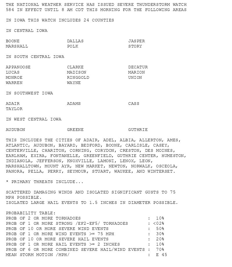
THE NATIONAL WEATHER SERVICE HAS ISSUED SEVERE THUNDERSTORM WATCH
584 IN EFFECT UNTIL 8 AM CDT THIS MORNING FOR THE FOLLOWING AREAS
IN IOWA THIS WATCH INCLUDES 24 COUNTIES
IN CENTRAL IOWA
BOONE DALLAS JASPER
MARSHALL POLK STORY
IN SOUTH CENTRAL IOWA
APPANOOSE CLARKE DECATUR
LUCAS MADISON MARION
MONROE RINGGOLD UNION
WARREN WAYNE
IN SOUTHWEST IOWA
ADAIR ADAMS CASS
TAYLOR
IN WEST CENTRAL IOWA
AUDUBON GREENE GUTHRIE
THIS INCLUDES THE CITIES OF ADAIR, ADEL, ALBIA, ALLERTON, AMES,
ATLANTIC, AUDUBON, BAYARD, BEDFORD, BOONE, CARLISLE, CASEY,
CENTERVILLE, CHARITON, CORNING, CORYDON, CRESTON, DES MOINES,
EARLHAM, EXIRA, FONTANELLE, GREENFIELD, GUTHRIE CENTER, HUMESTON,
INDIANOLA, JEFFERSON, KNOXVILLE, LAMONI, LENOX, LEON,
MARSHALLTOWN, MOUNT AYR, NEW MARKET, NEWTON, NORWALK, OSCEOLA,
PANORA, PELLA, PERRY, SEYMOUR, STUART, WAUKEE, AND WINTERSET.
* PRIMARY THREATS INCLUDE...
SCATTERED DAMAGING WINDS AND ISOLATED SIGNIFICANT GUSTS TO 75
MPH POSSIBLE.
ISOLATED LARGE HAIL EVENTS TO 1.5 INCHES IN DIAMETER POSSIBLE.
PROBABILITY TABLE:
PROB OF 2 OR MORE TORNADOES : 10%
PROB OF 1 OR MORE STRONG /EF2-EF5/ TORNADOES : <02%
PROB OF 10 OR MORE SEVERE WIND EVENTS : 50%
PROB OF 1 OR MORE WIND EVENTS >= 75 MPH : 30%
PROB OF 10 OR MORE SEVERE HAIL EVENTS : 20%
PROB OF 1 OR MORE HAIL EVENTS >= 2 INCHES : 10%
PROB OF 6 OR MORE COMBINED SEVERE HAIL/WIND EVENTS : 70%
MEAN STORM MOTION /MPH/ : E 45
🚨 Severe Thunderstorm Watch issued August 10 at 2:55AM CDT until August 10 at 8:00AM CDT by NWS Des Moines IA 🚨
Additional Details Here.
10.08.2025 08:00 — 👍 0 🔁 0 💬 0 📌 0
SPC issues Severe Thunderstorm Watch 584 till 13:00Z for portions of DMX
at Sun, 10 Aug 2025 07:47:24 +0000 via IEMbot
Additional Details Here.
10.08.2025 07:48 — 👍 0 🔁 0 💬 0 📌 0
DES MOINES IA Aug 9
Climate Report:
High: 83
Low: 74
Precip: 0.1"
Snow: 0.0"
at Sun, 10 Aug 2025 07:06:53 +0000 via IEMbot
Additional Details Here.
10.08.2025 07:08 — 👍 0 🔁 0 💬 0 📌 0
Storm Prediction Center issues Mesoscale Discussion #1920 concerning SEVERE POTENTIAL...SEVERE THUNDERSTORM WATCH LIKELY [watch prob: 95%] [Most Prob: Tornado: UP TO 95 MPH, Hail: ... at Sun, 10 Aug 2025 06:45:53 +0000 via IEMbot
Additional Details Here.
10.08.2025 06:48 — 👍 0 🔁 0 💬 0 📌 0
Weather Prediction Center issues Mesoscale Precipitation Discussion #890 concerning HEAVY RAINFALL...FLASH FLOODING LIKELY
at Sun, 10 Aug 2025 06:23:40 +0000 via IEMbot
Additional Details Here.
10.08.2025 06:27 — 👍 0 🔁 0 💬 0 📌 0
DMX issues Area Forecast Discussion (AFD) at Aug 10, 12:52 AM CDT ...Updated for the 06z Aviation Discussion... via IEMbot
Additional Details Here.
10.08.2025 06:08 — 👍 0 🔁 0 💬 0 📌 0
[Delayed Report] 1 NE Fort Dodge [Webster Co, IA] Public reports Tstm Wnd Dmg at 9 Aug, 7:19 AM CDT -- Large tree down at this location, few others reported in town. Time estimated... at Sun, 10 Aug 2025 03:29:08 +0000 via IEMbot
Additional Details Here.
10.08.2025 03:48 — 👍 0 🔁 0 💬 0 📌 0
[Delayed Report] 2 N Glidden [Carroll Co, IA] Public reports Tstm Wnd Dmg at 9 Aug, 7:15 AM CDT -- Large pine uprooted and garage doors pushed in. Delayed report via social media, ... at Sun, 10 Aug 2025 03:04:03 +0000 via IEMbot
Additional Details Here.
10.08.2025 03:07 — 👍 0 🔁 0 💬 0 📌 0
[Delayed Report] Breda [Carroll Co, IA] Public reports Tstm Wnd Dmg at 9 Aug, 7:10 AM CDT -- Large tree, unclear is rotted or healthy, snapped at base. Few other small branches in ... at Sun, 10 Aug 2025 02:34:02 +0000 via IEMbot
Additional Details Here.
10.08.2025 02:48 — 👍 0 🔁 0 💬 0 📌 0
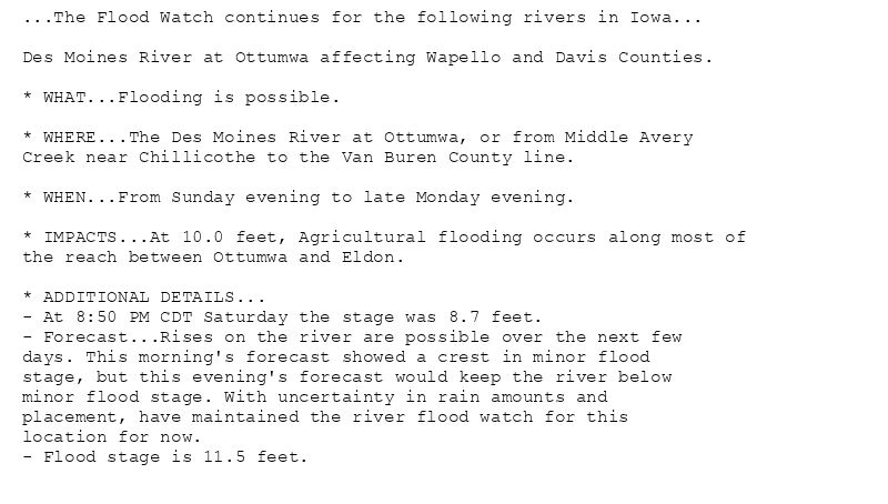
...The Flood Watch continues for the following rivers in Iowa...
Des Moines River at Ottumwa affecting Wapello and Davis Counties.
* WHAT...Flooding is possible.
* WHERE...The Des Moines River at Ottumwa, or from Middle Avery
Creek near Chillicothe to the Van Buren County line.
* WHEN...From Sunday evening to late Monday evening.
* IMPACTS...At 10.0 feet, Agricultural flooding occurs along most of
the reach between Ottumwa and Eldon.
* ADDITIONAL DETAILS...
- At 8:50 PM CDT Saturday the stage was 8.7 feet.
- Forecast...Rises on the river are possible over the next few
days. This morning's forecast showed a crest in minor flood
stage, but this evening's forecast would keep the river below
minor flood stage. With uncertainty in rain amounts and
placement, have maintained the river flood watch for this
location for now.
- Flood stage is 11.5 feet.
🚨 Flood Watch issued August 9 at 9:23PM CDT until August 11 at 10:45PM CDT by NWS Des Moines IA 🚨
Additional Details Here.
10.08.2025 02:30 — 👍 0 🔁 0 💬 0 📌 0
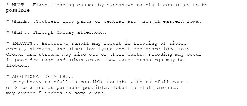
* WHAT...Flash flooding caused by excessive rainfall continues to be
possible.
* WHERE...Southern into parts of central and much of eastern Iowa.
* WHEN...Through Monday afternoon.
* IMPACTS...Excessive runoff may result in flooding of rivers,
creeks, streams, and other low-lying and flood-prone locations.
Creeks and streams may rise out of their banks. Flooding may occur
in poor drainage and urban areas. Low-water crossings may be
flooded.
* ADDITIONAL DETAILS...
- Very heavy rainfall is possible tonight with rainfall rates
of 2 to 3 inches per hour possible. Total rainfall amounts
may exceed 5 inches in some areas.
🚨 Flood Watch issued August 9 at 9:20PM CDT until August 11 at 1:00PM CDT by NWS Des Moines IA 🚨
Additional Details Here.
10.08.2025 02:30 — 👍 0 🔁 0 💬 0 📌 0
DMX continues Flood Watch for Adair, Adams, Appanoose, Black Hawk, Boone, Bremer, Clarke, Dallas, Davis, Decatur, Grundy, Hardin, Jasper, Lucas, Madison, Mahaska, Marion, Marshall,... at Sun, 10 Aug 2025 02:20:47 +0000 via IEMbot
Additional Details Here.
10.08.2025 02:28 — 👍 0 🔁 0 💬 0 📌 0
WCO issues Area Hydrological Discussion (AHD) at Aug 9, 7:51 PM CDT
at Sun, 10 Aug 2025 01:01:07 +0000 via IEMbot
Additional Details Here.
10.08.2025 01:08 — 👍 0 🔁 0 💬 0 📌 0
Weather Prediction Center issues Mesoscale Precipitation Discussion #888 concerning HEAVY RAINFALL...FLASH FLOODING LIKELY
at Sun, 10 Aug 2025 00:47:05 +0000 via IEMbot
Additional Details Here.
10.08.2025 00:48 — 👍 0 🔁 0 💬 0 📌 0
DMX issues Area Forecast Discussion (AFD) at Aug 9, 6:45 PM CDT ...Updated for the 00z Aviation Discussion... via IEMbot
Additional Details Here.
09.08.2025 23:48 — 👍 0 🔁 0 💬 0 📌 0
DES MOINES IA Aug 9
Climate Report:
High: 83
Low: 74
Precip: 0.1"
Snow: 0.0" Snow Depth: 0"
at Sat, 09 Aug 2025 22:30:45 +0000 via IEMbot
Additional Details Here.
09.08.2025 22:48 — 👍 0 🔁 0 💬 0 📌 0
Humboldt [Humboldt Co, IA] Public reports Tstm Wnd Dmg at 8:27 AM CDT -- Report of trees and branches down across town, via social media. Time estimated by radar.
at Sat, 09 Aug 2025 21:48:53 +0000 via IEMbot
Additional Details Here.
09.08.2025 22:08 — 👍 0 🔁 0 💬 0 📌 0
DMX issues Hazardous Weather Outlook (HWO) at Aug 9, 4:18 PM CDT
at Sat, 09 Aug 2025 21:18:37 +0000 via IEMbot
Additional Details Here.
09.08.2025 21:28 — 👍 0 🔁 0 💬 0 📌 0
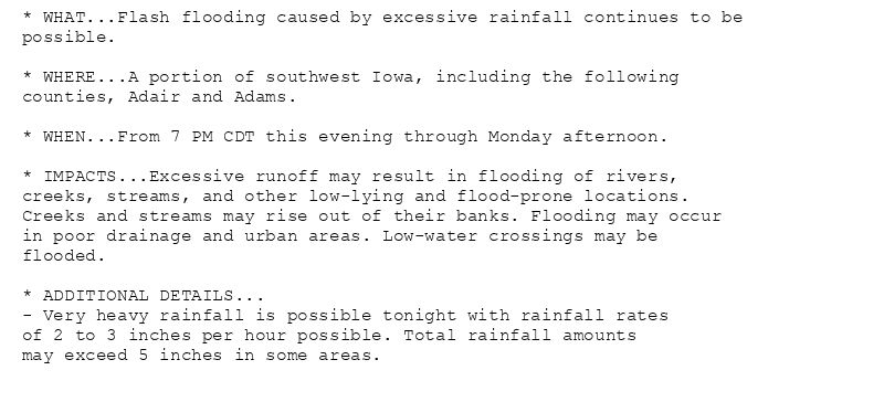
* WHAT...Flash flooding caused by excessive rainfall continues to be
possible.
* WHERE...A portion of southwest Iowa, including the following
counties, Adair and Adams.
* WHEN...From 7 PM CDT this evening through Monday afternoon.
* IMPACTS...Excessive runoff may result in flooding of rivers,
creeks, streams, and other low-lying and flood-prone locations.
Creeks and streams may rise out of their banks. Flooding may occur
in poor drainage and urban areas. Low-water crossings may be
flooded.
* ADDITIONAL DETAILS...
- Very heavy rainfall is possible tonight with rainfall rates
of 2 to 3 inches per hour possible. Total rainfall amounts
may exceed 5 inches in some areas.
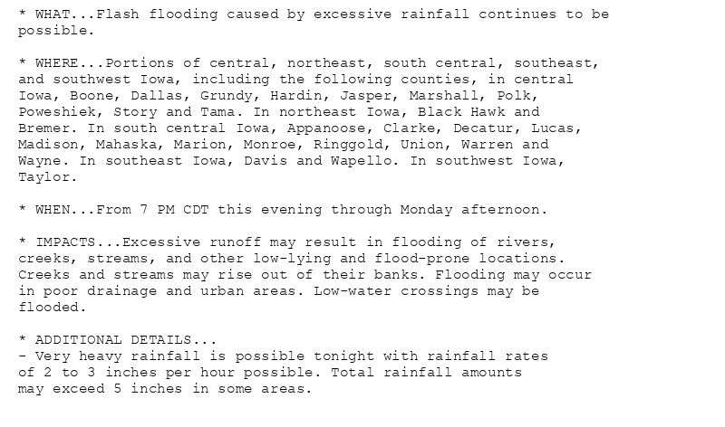
* WHAT...Flash flooding caused by excessive rainfall continues to be
possible.
* WHERE...Portions of central, northeast, south central, southeast,
and southwest Iowa, including the following counties, in central
Iowa, Boone, Dallas, Grundy, Hardin, Jasper, Marshall, Polk,
Poweshiek, Story and Tama. In northeast Iowa, Black Hawk and
Bremer. In south central Iowa, Appanoose, Clarke, Decatur, Lucas,
Madison, Mahaska, Marion, Monroe, Ringgold, Union, Warren and
Wayne. In southeast Iowa, Davis and Wapello. In southwest Iowa,
Taylor.
* WHEN...From 7 PM CDT this evening through Monday afternoon.
* IMPACTS...Excessive runoff may result in flooding of rivers,
creeks, streams, and other low-lying and flood-prone locations.
Creeks and streams may rise out of their banks. Flooding may occur
in poor drainage and urban areas. Low-water crossings may be
flooded.
* ADDITIONAL DETAILS...
- Very heavy rainfall is possible tonight with rainfall rates
of 2 to 3 inches per hour possible. Total rainfall amounts
may exceed 5 inches in some areas.
🚨 Flood Watch issued August 9 at 3:07PM CDT until August 11 at 1:00PM CDT by NWS Des Moines IA 🚨
Additional Details Here.
09.08.2025 20:15 — 👍 0 🔁 0 💬 0 📌 0
Storm Prediction Center issues Mesoscale Discussion #1914 concerning SEVERE POTENTIAL...WATCH POSSIBLE [watch prob: 40%] [Most Prob: Gust: 55-70 MPH]
at Sat, 09 Aug 2025 19:54:43 +0000 via IEMbot
Additional Details Here.
09.08.2025 20:08 — 👍 0 🔁 0 💬 0 📌 0
DMX issues Area Forecast Discussion (AFD) at Aug 9, 2:59 PM CDT
at Sat, 09 Aug 2025 19:59:16 +0000 via IEMbot
Additional Details Here.
09.08.2025 20:08 — 👍 0 🔁 0 💬 0 📌 0
Halbur [Carroll Co, IA] Emergency Mngr reports Tstm Wnd Dmg at 7:20 AM CDT -- Emergency manager reported trees down in Halbur. Time estimated from radar.
at Sat, 09 Aug 2025 18:34:41 +0000 via IEMbot
Additional Details Here.
09.08.2025 18:47 — 👍 0 🔁 0 💬 0 📌 0
3 ESE Arcadia [Carroll Co, IA] Emergency Mngr reports Tstm Wnd Dmg at 7:22 AM CDT -- Emergency manager reported damage to sheds and outbuildings. Time estimated from radar.
at Sat... at Sat, 09 Aug 2025 18:22:50 +0000 via IEMbot
Additional Details Here.
09.08.2025 18:27 — 👍 0 🔁 0 💬 0 📌 0
DMX issues Area Forecast Discussion (AFD) at Aug 9, 12:55 PM CDT ...Updated for the 18z Aviation Discussion... via IEMbot
Additional Details Here.
09.08.2025 18:08 — 👍 0 🔁 0 💬 0 📌 0