Global map showing sea surface temperature anomalies in September 2025 relative to 1982 to 2010. Most areas are warmer than average. Red is shown for warmer sea surface temperatures, and blue is shown for colder sea surface temperatures. Data is from NOAA OISSTv2.1.
There's a lot to look at in last month's map of average sea surface temperature anomalies. The La Niña signature continues to become more prominent. Meanwhile, the absurd record warmth over the North Pacific is still extending all the way from Asia to North America.
Data from NOAA OISSTv2.1 🌊
16.10.2025 23:31 —
👍 144
🔁 54
💬 4
📌 7

Top Scientists Find Growing Evidence That Greenhouse Gases Are, in Fact, a Danger
🧪 New National Academies report concludes that rising greenhouse gas levels imperil public health and the 2009 endangerment finding “has stood the test of time.” Game on.
Gift link:
Top Scientists Find Growing Evidence That Greenhouse Gases Are, in Fact, a Danger www.nytimes.com/2025/09/17/c...
18.09.2025 01:02 —
👍 134
🔁 64
💬 4
📌 1

Time series of monthly Northern Pacific Ocean sea surface temperature anomalies from 1850 to August 2025 alongside multi-model expectations of the warming in this area (scenario SSP2-4.5).
The Northern Pacific Ocean is currently smashing temperature records.
And it is reaching these levels far earlier than the current generation of climate models had expected.
A short thread 🧵
18.09.2025 10:45 —
👍 552
🔁 264
💬 12
📌 37
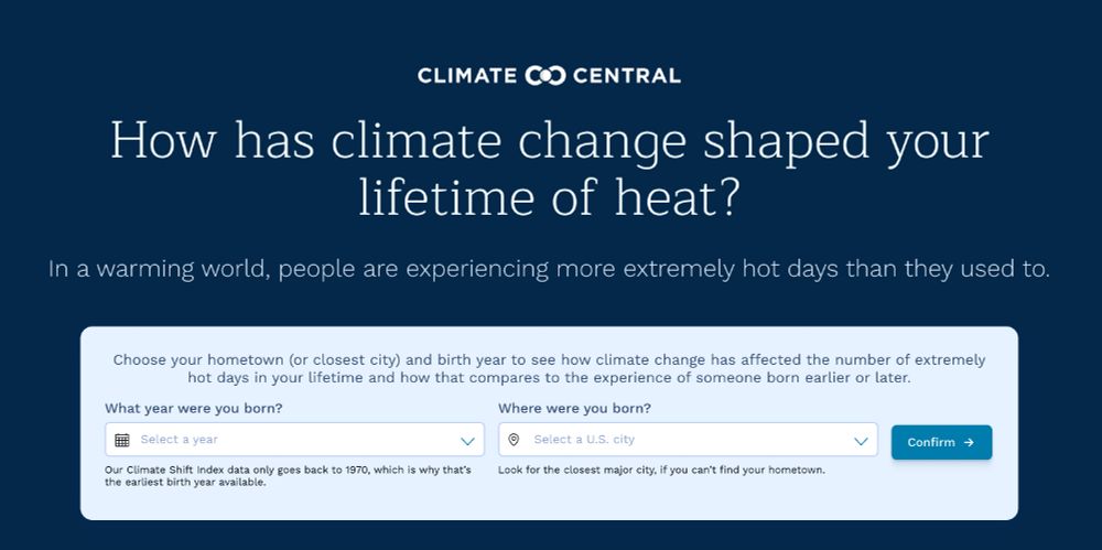
Screenshot for the interactive tool to enter year you were born and where for how has climate change shaped your lifetime of heat? In a warming world, people are experiencing more extremely hot days than they used to.
How has climate change shaped your lifetime of heat?
Younger people today are experiencing more extremely hot days during their childhood compared to previous generations.
Check out the new interactive tool by @climatecentral.org: climatecentral.observablehq.cloud/generational...
03.09.2025 19:59 —
👍 134
🔁 45
💬 7
📌 2
DOEresponseSite
On July 29, 2025, the Department of Energy (DOE) published a report from its Climate Working Group (CWG). This report features prominently in the EPA's reconsideration of its 2009 Endangerment Finding...
The Department of Energy hired five academics to raise doubts about climate change. 85+ climate experts (organized by @andrewdessler.com) reviewed their report. Our conclusion, detailed in 450 pages of analysis: it is biased, full of errors, and not fit to inform policy making.
02.09.2025 13:07 —
👍 1192
🔁 507
💬 21
📌 37

https://x.com/MichaelEMann/status/1809277799896871363
Just so we're all clear, I've added Judith Curry's 2014 "hiatus" (no additional warming) prediction on this graph showing what's actually happened since:
22.08.2025 00:48 —
👍 312
🔁 76
💬 7
📌 5
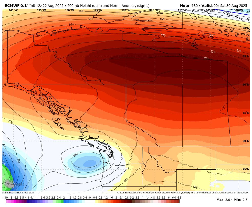

A long-major heatwave is setting up for Central & NW Canada with temperatures 15-20 degrees C (30F plus) warmer than normal late next week into next weekend. That means widespread 30-35C high temps (85-95F) way up north even near the Tundra. Climate change has made these events more intense/ likely
23.08.2025 21:25 —
👍 95
🔁 49
💬 3
📌 5

NASA’s acting chief calls for the end of Earth science at the space agency
NASA’s charter clearly states the agency should study planet Earth, however.
Sean Duffy, Acting Chief of NASA: "All the climate science ... we’re going to move aside, and all of the science that we do is going to be directed towards exploration ... That’s why we have NASA, to explore, not to do all of these Earth sciences."
arstechnica.com/space/2025/0...
15.08.2025 23:17 —
👍 40
🔁 12
💬 12
📌 6


Berg Glacier Lake, Alaska has drained. NASA Earth Observatory shared my earlier observations of filling, and by 8-3-2025 it had drained.
landsat.visibleearth.nasa.gov/view.php?id=...
15.08.2025 23:19 —
👍 7
🔁 1
💬 0
📌 0
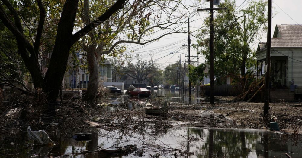
The Flooding Will Come “No Matter What”: Climate Change is Already Forcing People From Their Homes
The complex, contradictory and heartbreaking process of American climate migration is underway.
The Flooding Will Come “No Matter What”
The complex, contradictory and heartbreaking process of American climate migration is underway.
(Published April 2024)
11.08.2025 23:10 —
👍 4299
🔁 1482
💬 126
📌 81
Climate Science 101
Climate scientist Katharine Hayhoe explains the basics of climate change for beginners and those in need of a refresher.
Gain an understanding of climate change basics from renowned scientist @katharinehayhoe.com. Whether you’re new to the climate story or a veteran reporter aiming to refine how you explain it to audiences, this guide is for you.
04.08.2025 17:12 —
👍 86
🔁 49
💬 0
📌 2
Motherfucking wind farms…
30.07.2025 17:02 —
👍 47128
🔁 17686
💬 1139
📌 2377
Finally an animation - today's visualization addition shows changes in yearly temperature anomalies from 1940 to 2024...
Graphic can be downloaded from zacklabe.com/united-state... using ERA5 data.
26.07.2025 17:04 —
👍 209
🔁 70
💬 8
📌 5
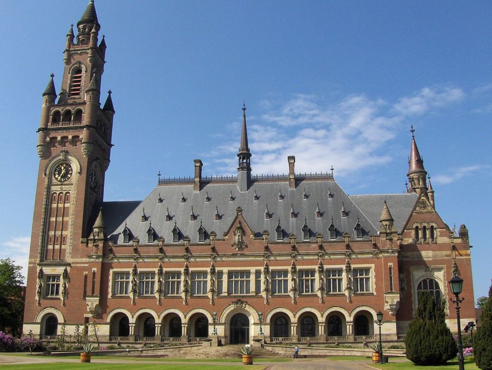
Landmark Ruling Gives Paris Climate Agreement Teeth
A rare unanimous ruling from the International Court of Justice creates a pathway to hold all governments, even the climate-denying ones, legally liable for climate risk.
The ruling from the International Court of Justice last week is genuinely a big fucking deal. It makes it a legal obligation for countries to address climate change. Yes, even the ones not signed on to Paris. Yes, even the U.S. More from me & @rishpardikar.bsky.social drilled.media/news/ijc-1
26.07.2025 18:45 —
👍 289
🔁 99
💬 5
📌 14
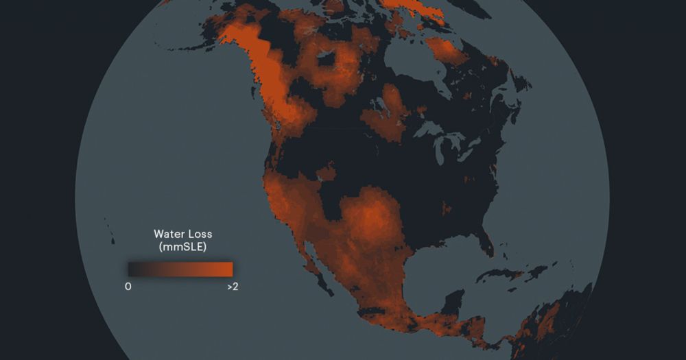
“Staggering” Water Loss Driven by Groundwater Mining Poses Global Threat
A new study finds that freshwater resources are rapidly disappearing, creating arid “mega” regions and causing sea levels to rise.
This is a pretty alarming new study out today (doi.org/10.1126/scia... - read the abstract) and here are some great visuals and highlights from it by @propublica.org: www.propublica.org/article/wate...
"Since 2002, 75% of the population lives in 101 countries that have been losing freshwater water"
25.07.2025 19:40 —
👍 183
🔁 112
💬 9
📌 16

H042 - Applications in Snow Hydrology (AGU25 session)
We invite submissions broadly related to hydrological processes that govern snowpack contributions to streamflow, with potential topics including but not limited to:
1. Seasonal snowpack partitioning, including sublimation, evapotranspiration, runoff, & soil moisture
2. Precipitation phase and snowmelt (rate, timing, and amount) impacts on streamflow
3. Advancements in understanding of snow-derived streamflow across different scales and under historical and/or future conditions
Primary Convener:
Laurie Huning, California State University Long Beach
Conveners:
Melissa Wrzesien, NASA Goddard Space Flight Center
Daniel McEvoy, Desert Research Institute
Elizabeth Burakowski, University of New Hampshire
Early Career Convener:
Eunsaem Cho, NASA Goddard Space Flight Center
Invited Speakers:
Haejo Kim, Syracuse University
and
Keith Musselman, University of Colorado, Boulder
Image of snow mountain with rocky stream in foreground
Submit by July 30 to our #AGU25 Applications in Snow Hydrology (H042) session. Confirmed invited speakers include Haejo Kim (Syracuse) and Keith Musselman (CU Boulder).
#snow #hydrology
15.07.2025 20:33 —
👍 6
🔁 1
💬 1
📌 0
Trump administration says it won't publish major climate change reports on NASA website as promised
The Trump administration has made it harder for people, local and state governments to find critical climate change reports.
As I say here, “This document was written for the American people, paid for by the taxpayers, and it contains vital information we need to keep ourselves safe in a changing climate, as the disasters that continue to mount demonstrate so tragically and clearly.”
More by @borenbears.bsky.social here:
16.07.2025 02:09 —
👍 521
🔁 236
💬 12
📌 9
It’ll be a super snowy session! Miss you, Lizz, It’s been way too long!
16.07.2025 02:23 —
👍 1
🔁 0
💬 1
📌 0
H042 - Applications in Snow Hydrology (AGU25 session)
We invite submissions broadly related to hydrological processes that govern snowpack contributions to streamflow, with potential topics including but not limited to:
1. Seasonal snowpack partitioning, including sublimation, evapotranspiration, runoff, & soil moisture
2. Precipitation phase and snowmelt (rate, timing, and amount) impacts on streamflow
3. Advancements in understanding of snow-derived streamflow across different scales and under historical and/or future conditions
Primary Convener:
Laurie Huning, California State University Long Beach
Conveners:
Melissa Wrzesien, NASA Goddard Space Flight Center
Daniel McEvoy, Desert Research Institute
Elizabeth Burakowski, University of New Hampshire
Early Career Convener:
Eunsaem Cho, NASA Goddard Space Flight Center
Invited Speakers:
Haejo Kim, Syracuse University
and
Keith Musselman, University of Colorado, Boulder
Image of snow mountain with rocky stream in foreground
Submit by July 30 to our #AGU25 Applications in Snow Hydrology (H042) session. Confirmed invited speakers include Haejo Kim (Syracuse) and Keith Musselman (CU Boulder).
#snow #hydrology
15.07.2025 20:33 —
👍 6
🔁 1
💬 1
📌 0
Yeah this is the thing I'm told me and all my students need to uncritically embrace so they can get a job after college
15.07.2025 02:06 —
👍 230
🔁 67
💬 8
📌 0
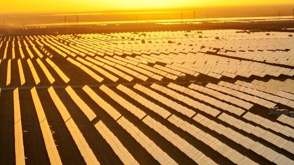
4.6 Billion Years On, the Sun Is Having a Moment
In the past two years, without much notice, solar power has begun to truly transform the world’s energy system.
This is a great article by Bill McKibben @billmckibben.bsky.social on how solar power hit an inflection point and has now become an unstoppable force.
A must read.
www.newyorker.com/news/annals-...
14.07.2025 05:17 —
👍 193
🔁 63
💬 7
📌 1
Recipients of a U.S. Climate Science Fellowship Are Put on Unpaid Leave
Under Trump, NOAA ran the most recent competition for their highly prestigious postdoc program in climate and global change — but funded no one, wasting huge amounts of applicant and reviewer time.
It gets a lot worse. Now current postdocs in the program are going unpaid.
09.07.2025 19:22 —
👍 352
🔁 164
💬 11
📌 8

‘It’s a nightmare.’ U.S. funding cuts threaten academic science jobs at all levels
“There is a lot of pressure to essentially leave the country or not pursue research,” one Ph.D. student says
I can't stress enough how close U.S. science is to the cliff.
"Numbers released in May by the National Science Foundation (NSF) indicate that if Congress approves the cuts to the agency proposed by the White House, the number of early-career researchers it supports could fall by 78%" (@science.org)
08.07.2025 15:36 —
👍 1463
🔁 839
💬 44
📌 72
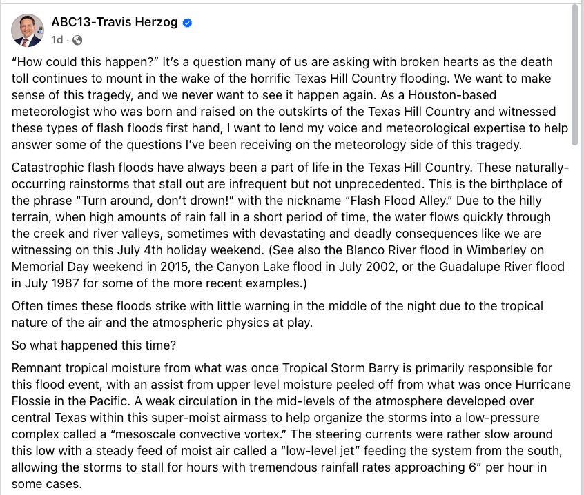
“How could this happen?” It’s a question many of us are asking with broken hearts as the death toll continues to mount in the wake of the horrific Texas Hill Country flooding. We want to make sense of this tragedy, and we never want to see it happen again. As a Houston-based meteorologist who was born and raised on the outskirts of the Texas Hill Country and witnessed these types of flash floods first hand, I want to lend my voice and meteorological expertise to help answer some of the questions I’ve been receiving on the meteorology side of this tragedy.
Catastrophic flash floods have always been a part of life in the Texas Hill Country. These naturally-occurring rainstorms that stall out are infrequent but not unprecedented. This is the birthplace of the phrase “Turn around, don’t drown!” with the nickname “Flash Flood Alley.” Due to the hilly terrain, when high amounts of rain fall in a short period of time, the water flows quickly through the creek and river valleys, sometimes with devastating and deadly consequences like we are witnessing on this July 4th holiday weekend. (See also the Blanco River flood in Wimberley on Memorial Day weekend in 2015, the Canyon Lake flood in July 2002, or the Guadalupe River flood in July 1987 for some of the more recent examples.)
Often times these floods strike with little warning in the middle of the night due to the tropical nature of the air and the atmospheric physics at play.
So what happened this time?
Remnant tropical moisture from what was once Tropical Storm Barry is primarily responsible for this flood event, with an assist from upper level moisture peeled off from what was once Hurricane Flossie in the Pacific. A weak circulation in the mid-levels of the atmosphere developed over central Texas within this super-moist airmass to help organize the storms into a low-pressure complex called a “mesoscale convective vortex.” The steering currents were rather slow around this low with a steady feed of moist air called a “l…

How difficult is it to predict these flash floods?
When I was studying meteorology at Texas A&M over 20 years ago, I remember being taught that the most difficult thing to predict was how much rain would fall and where that rain would fall. While we have made tremendous progress in “quantitive precipitation forecasts” over the last two decades, this is largely still true today. No meteorologist could have told you with high confidence more than a few hours in advance that *this* much rain would fall in those *exact* locations.
But thanks to a forecasting technique known as “pattern recognition” (which comes with experience and studying past weather patterns) and the guidance offered up by more sophisticated “convection allowing models,” meteorologists already had a sense flash floods were possible on Thursday afternoon (when the National Weather Service issued a Flood Watch), and by Thursday evening they had a sense that something big was potentially brewing. I have attached the “mesoscale precipitation discussion” issued by NOAA’s Weather Prediction Center issued shortly after 6PM CT Thursday to put an extra focus on the dangerous flood ingredients that were coming together over the Hill Country. It is loaded with meteorological jargon, but it’s there for you to read if you so desire. I have also attached the “quantitative precipitation forecasts” (or QPF) from the high resolution “convection allowing models” (or CAMs) that came out Thursday morning. Some of them do show over 10” of rain falling north and west of San Antonio through 7AM on July 4th.
Yet even on Thursday evening, no meteorologist could have accurately predicted with high confidence the specific rain amounts that fell in the precise locations where they fell, and the atmosphere exceeded even the worst projections of the computer models both in coverage and amounts of heavy rain, as is often the case with tropical rain events over Texas.
Did recent staffing cuts and vacancies within the National Weath…

I have looked back at the timeline of warnings issued by the National Weather Service along with communications in a National Weather Service Slack channel where NWS/NOAA meteorologists, broadcast media, and emergency managers share information during extreme weather events, and I agree with assessments I’ve seen from other meteorologists that the National Weather Service issued timely warnings as the event unfolded in real-time. The first Flash Flood Warning for Kerr County was issued around 1 a.m., and the first Flash Flood Emergency (highest level of flood warning issued in the most extreme, life-threatening situations) was issued around 4AM, which automatically triggers a “Wireless Emergency Alert” to all cell phones within the warned area (unless users have elected to turn off those alerts). I’m also told by houston’s former NWS Warning Coordination Meteorologist Dan Reilly that flash flood warnings issued hours earlier also contained a “considerable tag” that would’ve also triggered cell phone alerts in the middle of the night where cell service was available.
It certainly didn’t help the situation that the Austin/San Antonio NWS weather forecast office is understaffed by 22% and without a Warning Coordination Meteorologist, but I see no evidence yet that it hurt the situation either with what I know.
What I am not privy to are all the communications the NWS had with emergency managers and local officials in the middle of night outside of the Slack Channel we use to communicate and share information. Therefore, I cannot comment on what was done with the information and warnings pushed out by the National Weather Service, nor do I know how many meteorologists were staffed in the office to work this event.

What role did our changing climate have in this flood?
The scientific body of evidence indicates that our warmer atmosphere and oceans increase the likelihood of these extreme precipitation events and the amount of rain that falls when they occur. The physics is pretty simple: Warmer oceans release more moisture into the atmosphere, and warmer air also holds more moisture. This enhances rainfall amounts above and beyond what would happen in a cooler world with cooler oceans.
What about cloud seeding? (Added at 2PM because of all the genuine questions about it.)
Cloud seeding cannot create a storm of this magnitude or size. In fact, cloud seeding cannot even create a single cloud. All it can do is take an existing cloud and enhance the rainfall by up to 20%. Most estimates have the rainfall enhancement in a much lower range. I am unaware of any active cloud seeding operations that occurred on Thursday night, but it is physically impossible for that to have created this weather system. This is a matter of scale. If I blow out a candle with my breath, does that mean I can then go blow out a raging wildfire? It is the same with cloud-seeding. For more, see this excellent report by my ABC colleague Ginger Zee: https://abcnews.go.com/.../ginger-zee-clears-air-cloud...
There are many other questions that remain, like what can be done to protect people from future floods, and what can we do to help now? Hopefully there will be changes made and systems put in place to help protect people in the Hill Country from future flash floods that occur in the middle of the night, and as soon as I have a list compiled of ways to help the flood victims and their families, I will share it here.
For now on this Day of Prayer in Texas, my prayers remain with the missing, the families of the flood victims, the first responders, and those tasked with leading us through the aftermath. 🙏🏻 🙏🏻🙏🏻
this is an excellent discussion of the July 4th Hill Country floods by @travisabc13.bsky.social, ABC13's chief meteorologist and a graduate of our program, @tamuatmo.bsky.social.
07.07.2025 21:40 —
👍 97
🔁 43
💬 3
📌 0
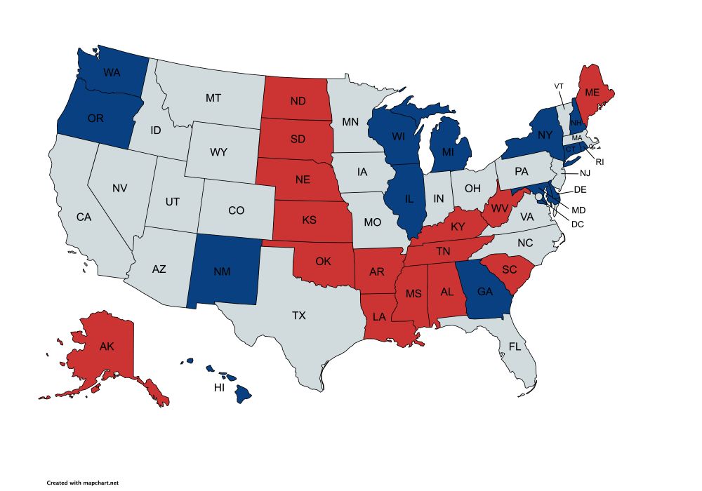
A map of the US with the states the republican senators are from marked in red and states the democratic senators are from marked in blue:
Senator Susan Collins (Republican - Maine)
Senator Mitch McConnell(Republican - Kentucky)
Senator Lisa Murkowski(Republican - Alaska)
Senator Lindsey Graham(Republican - South Carolina)
Senator Jerry Moran(Republican - Kansas)
Senator John Hoeven(Republican - North Dakota)
Senator John Boozman(Republican - Arkansas)
Senator Shelley Moore Capito(Republican - West Virginia)
Senator John Kennedy(Republican - Louisiana)
Senator Cindy Hyde-Smith(Republican - Mississippi)
Senator Bill Hagerty(Republican - Tennessee)
Senator Katie Britt(Republican - Alabama)
Senator Markwayne Mullin(Republican - Oklahoma)
Senator Deb Fischer(Republican - Nebraska)
Senator Mike Rounds(Republican - South Dakota)
Patty Murray(Democrat - Washington)
Richard Durbin(Democrat - Illinois)
Jack Reed(Democrat - Rhode Island)
Jeanne Shaheen(Democrat - New Hampshire)
Jeff Merkley(Democrat - Oregon)
Christopher Coons(Democrat - Delaware)
Brian Schatz(Democrat - Hawaii)
Tammy Baldwin(Democrat - Wisconsin)
Chris Murphy(Democrat - Connecticut)
Chris Van Hollen(Democrat - Maryland)
Martin Heinrich(Democrat - New Mexico)
Gary Peters(Democrat - Michigan)
Kirsten Gillibrand(Democrat - New York)
Jon Ossoff(Democrat - Georgia)
Are you from one of these states? Then we need your help to save American science!
The Senate Appropriations Committee will be marking up the President's Budget Request for science on Wednesday. People have been saying the proposed cuts "decimated" US science, but that's wrong: they are apocalyptic
07.07.2025 18:23 —
👍 374
🔁 321
💬 17
📌 46