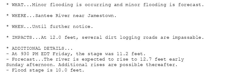
* WHAT...Minor flooding is occurring and minor flooding is forecast.
* WHERE...Santee River near Jamestown.
* WHEN...Until further notice.
* IMPACTS...At 12.0 feet, several dirt logging roads are impassable.
* ADDITIONAL DETAILS...
- At 930 PM EDT Friday, the stage was 11.2 feet.
- Forecast...The river is expected to rise to 12.7 feet early
Sunday afternoon. Additional rises are possible thereafter.
- Flood stage is 10.0 feet.
🚨 Flood Warning issued August 15 at 10:05PM EDT by NWS Charleston SC 🚨
Additional Details Here.
16.08.2025 02:15 — 👍 0 🔁 0 💬 0 📌 0
CHS continues Flood Warning for Santee River near Jamestown [SC] until further notice
at Sat, 16 Aug 2025 02:06:05 +0000 via IEMbot
Additional Details Here.
16.08.2025 02:06 — 👍 0 🔁 0 💬 0 📌 0
CHS issues Area Forecast Discussion (AFD) at Aug 15, 9:02 PM EDT
at Sat, 16 Aug 2025 01:04:10 +0000 via IEMbot
Additional Details Here.
16.08.2025 01:06 — 👍 0 🔁 0 💬 0 📌 0
CHS expires Flood Advisory for Bryan, Effingham [GA]
at Sat, 16 Aug 2025 00:30:23 +0000 via IEMbot
Additional Details Here.
16.08.2025 00:46 — 👍 0 🔁 0 💬 0 📌 0
CHS expires Marine Warning for Coastal waters from Edisto Beach SC to Savannah GA out 20 nm [AM]
at Fri, 15 Aug 2025 23:26:31 +0000 via IEMbot
Additional Details Here.
15.08.2025 23:46 — 👍 0 🔁 0 💬 0 📌 0
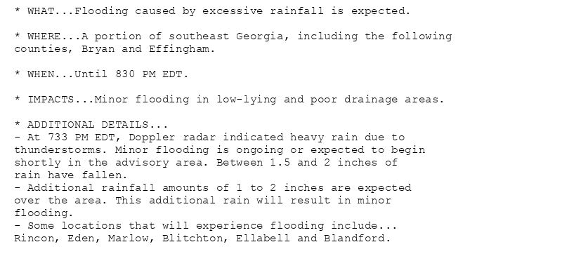
* WHAT...Flooding caused by excessive rainfall is expected.
* WHERE...A portion of southeast Georgia, including the following
counties, Bryan and Effingham.
* WHEN...Until 830 PM EDT.
* IMPACTS...Minor flooding in low-lying and poor drainage areas.
* ADDITIONAL DETAILS...
- At 733 PM EDT, Doppler radar indicated heavy rain due to
thunderstorms. Minor flooding is ongoing or expected to begin
shortly in the advisory area. Between 1.5 and 2 inches of
rain have fallen.
- Additional rainfall amounts of 1 to 2 inches are expected
over the area. This additional rain will result in minor
flooding.
- Some locations that will experience flooding include...
Rincon, Eden, Marlow, Blitchton, Ellabell and Blandford.
Flood Advisory issued August 15 at 7:33PM EDT until August 15 at 8:30PM EDT by NWS Charleston SC
Additional Details Here.
15.08.2025 23:45 — 👍 0 🔁 0 💬 0 📌 0
CHS issues A STRONG THUNDERSTORM WILL IMPACT JASPER AND CHATHAM COUNTIES UNTIL 730 PM EDT [wind: 50 MPH, hail: 0.75 IN] for Coastal Chatham, Inland Chatham [GA] and Coastal Jasper... at Fri, 15 Aug 2025 22:36:00 +0000 via IEMbot
Additional Details Here.
15.08.2025 22:46 — 👍 0 🔁 0 💬 0 📌 0
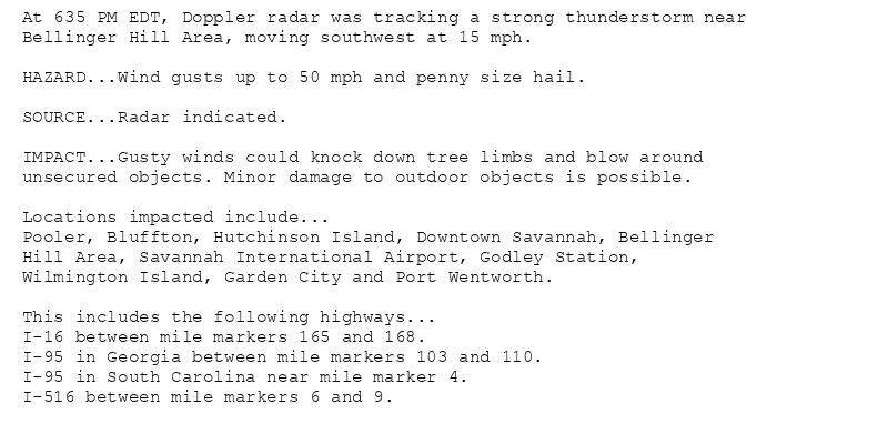
At 635 PM EDT, Doppler radar was tracking a strong thunderstorm near
Bellinger Hill Area, moving southwest at 15 mph.
HAZARD...Wind gusts up to 50 mph and penny size hail.
SOURCE...Radar indicated.
IMPACT...Gusty winds could knock down tree limbs and blow around
unsecured objects. Minor damage to outdoor objects is possible.
Locations impacted include...
Pooler, Bluffton, Hutchinson Island, Downtown Savannah, Bellinger
Hill Area, Savannah International Airport, Godley Station,
Wilmington Island, Garden City and Port Wentworth.
This includes the following highways...
I-16 between mile markers 165 and 168.
I-95 in Georgia between mile markers 103 and 110.
I-95 in South Carolina near mile marker 4.
I-516 between mile markers 6 and 9.
Special Weather Statement issued August 15 at 6:35PM EDT by NWS Charleston SC
Additional Details Here.
15.08.2025 22:45 — 👍 0 🔁 0 💬 0 📌 0
CHS issues Marine Warning [wind: 34 KTS, hail: 0.00 IN] for Coastal waters from Edisto Beach SC to Savannah GA out 20 nm [AM] till Aug 15, 7:30 PM EDT
at Fri, 15 Aug 2025 21:29:21 +0000 via IEMbot
Additional Details Here.
15.08.2025 21:46 — 👍 0 🔁 0 💬 0 📌 0
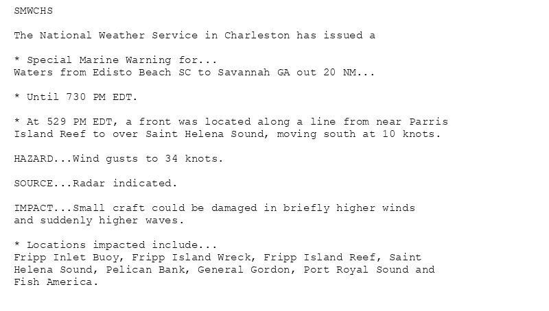
SMWCHS
The National Weather Service in Charleston has issued a
* Special Marine Warning for...
Waters from Edisto Beach SC to Savannah GA out 20 NM...
* Until 730 PM EDT.
* At 529 PM EDT, a front was located along a line from near Parris
Island Reef to over Saint Helena Sound, moving south at 10 knots.
HAZARD...Wind gusts to 34 knots.
SOURCE...Radar indicated.
IMPACT...Small craft could be damaged in briefly higher winds
and suddenly higher waves.
* Locations impacted include...
Fripp Inlet Buoy, Fripp Island Wreck, Fripp Island Reef, Saint
Helena Sound, Pelican Bank, General Gordon, Port Royal Sound and
Fish America.
🚨 Special Marine Warning issued August 15 at 5:29PM EDT until August 15 at 7:30PM EDT by NWS Charleston SC 🚨
Additional Details Here.
15.08.2025 21:45 — 👍 0 🔁 0 💬 0 📌 0
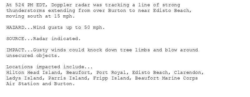
At 524 PM EDT, Doppler radar was tracking a line of strong
thunderstorms extending from over Burton to near Edisto Beach,
moving south at 15 mph.
HAZARD...Wind gusts up to 50 mph.
SOURCE...Radar indicated.
IMPACT...Gusty winds could knock down tree limbs and blow around
unsecured objects.
Locations impacted include...
Hilton Head Island, Beaufort, Port Royal, Edisto Beach, Clarendon,
Ladys Island, Parris Island, Fripp Island, Beaufort Marine Corps
Air Station and Burton.
Special Weather Statement issued August 15 at 5:24PM EDT by NWS Charleston SC
Additional Details Here.
15.08.2025 21:30 — 👍 0 🔁 0 💬 0 📌 0
SAVANNAH GA Aug 15
Climate Report:
High: 95
Low: 78
Precip: 0.0"
Snow: Missing
at Fri, 15 Aug 2025 21:15:28 +0000 via IEMbot
Additional Details Here.
15.08.2025 21:26 — 👍 0 🔁 0 💬 0 📌 0
1 SSW Goose Creek [Berkeley Co, SC] Emergency Mngr reports Lightning at 3:30 PM EDT -- Lightning strike caused a house fire on Leone Court.
at Fri, 15 Aug 2025 20:47:17 +0000 via IEMbot
Additional Details Here.
15.08.2025 21:06 — 👍 0 🔁 0 💬 0 📌 0
CHS expires Flood Advisory for Charleston, Dorchester [SC]
at Fri, 15 Aug 2025 20:39:41 +0000 via IEMbot
Additional Details Here.
15.08.2025 20:46 — 👍 0 🔁 0 💬 0 📌 0
CHS issues Flood Advisory for Charleston, Dorchester [SC] till 4:30 PM EDT
at Fri, 15 Aug 2025 19:33:57 +0000 via IEMbot
Additional Details Here.
15.08.2025 19:46 — 👍 0 🔁 0 💬 0 📌 0
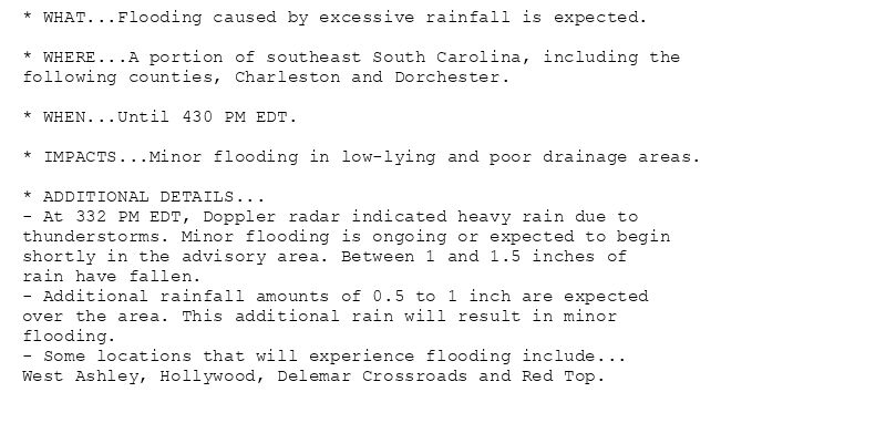
* WHAT...Flooding caused by excessive rainfall is expected.
* WHERE...A portion of southeast South Carolina, including the
following counties, Charleston and Dorchester.
* WHEN...Until 430 PM EDT.
* IMPACTS...Minor flooding in low-lying and poor drainage areas.
* ADDITIONAL DETAILS...
- At 332 PM EDT, Doppler radar indicated heavy rain due to
thunderstorms. Minor flooding is ongoing or expected to begin
shortly in the advisory area. Between 1 and 1.5 inches of
rain have fallen.
- Additional rainfall amounts of 0.5 to 1 inch are expected
over the area. This additional rain will result in minor
flooding.
- Some locations that will experience flooding include...
West Ashley, Hollywood, Delemar Crossroads and Red Top.
Flood Advisory issued August 15 at 3:33PM EDT until August 15 at 4:30PM EDT by NWS Charleston SC
Additional Details Here.
15.08.2025 19:45 — 👍 0 🔁 0 💬 0 📌 0
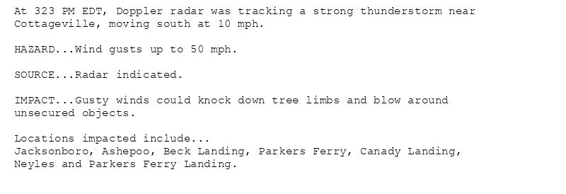
At 323 PM EDT, Doppler radar was tracking a strong thunderstorm near
Cottageville, moving south at 10 mph.
HAZARD...Wind gusts up to 50 mph.
SOURCE...Radar indicated.
IMPACT...Gusty winds could knock down tree limbs and blow around
unsecured objects.
Locations impacted include...
Jacksonboro, Ashepoo, Beck Landing, Parkers Ferry, Canady Landing,
Neyles and Parkers Ferry Landing.
Special Weather Statement issued August 15 at 3:23PM EDT by NWS Charleston SC
Additional Details Here.
15.08.2025 19:30 — 👍 0 🔁 0 💬 0 📌 0
CHS issues A STRONG THUNDERSTORM WILL IMPACT COLLETON AND CHARLESTON COUNTIES UNTIL 415 PM EDT [wind: 50 MPH, hail: 0.00 IN] for Charleston, Coastal Colleton, Inland Colleton [SC]... at Fri, 15 Aug 2025 19:23:37 +0000 via IEMbot
Additional Details Here.
15.08.2025 19:26 — 👍 0 🔁 0 💬 0 📌 0
CHS issues A STRONG THUNDERSTORM WILL IMPACT COLLETON AND DORCHESTER COUNTIES UNTIL 330 PM EDT [hail: 0.00 IN] for Dorchester, Inland Colleton [SC]
at Fri, 15 Aug 2025 18:43:54 +0000 via IEMbot
Additional Details Here.
15.08.2025 18:46 — 👍 0 🔁 0 💬 0 📌 0
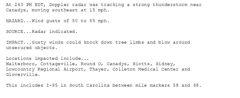
At 243 PM EDT, Doppler radar was tracking a strong thunderstorm near
Canadys, moving southeast at 15 mph.
HAZARD...Wind gusts of 50 to 55 mph.
SOURCE...Radar indicated.
IMPACT...Gusty winds could knock down tree limbs and blow around
unsecured objects.
Locations impacted include...
Walterboro, Cottageville, Round O, Canadys, Hiotts, Sidney,
Lowcountry Regional Airport, Thayer, Colleton Medical Center and
Gloverville.
This includes I-95 in South Carolina between mile markers 58 and 68.
Special Weather Statement issued August 15 at 2:43PM EDT by NWS Charleston SC
Additional Details Here.
15.08.2025 18:45 — 👍 0 🔁 0 💬 0 📌 0
CHS issues Area Forecast Discussion (AFD) at Aug 15, 2:00 PM EDT
at Fri, 15 Aug 2025 18:00:31 +0000 via IEMbot
Additional Details Here.
15.08.2025 18:06 — 👍 0 🔁 0 💬 0 📌 0
CHS issues Hazardous Weather Outlook (HWO) at Aug 15, 1:31 PM EDT
at Fri, 15 Aug 2025 17:32:18 +0000 via IEMbot
Additional Details Here.
15.08.2025 17:46 — 👍 0 🔁 0 💬 0 📌 0
CHS continues Heat Advisory for Coastal Bryan, Coastal Chatham, Coastal Liberty, Coastal McIntosh, Effingham, Inland Bryan, Inland Chatham, Inland Liberty, Inland McIntosh, Long [G... at Fri, 15 Aug 2025 16:08:04 +0000 via IEMbot
Additional Details Here.
15.08.2025 16:26 — 👍 0 🔁 0 💬 0 📌 0
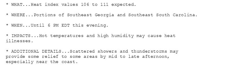
* WHAT...Heat index values 106 to 111 expected.
* WHERE...Portions of Southeast Georgia and Southeast South Carolina.
* WHEN...Until 6 PM EDT this evening.
* IMPACTS...Hot temperatures and high humidity may cause heat
illnesses.
* ADDITIONAL DETAILS...Scattered showers and thunderstorms may
provide some relief to some areas by mid to late afternoon,
especially near the coast.
Heat Advisory issued August 15 at 12:07PM EDT until August 15 at 6:00PM EDT by NWS Charleston SC
Additional Details Here.
15.08.2025 16:15 — 👍 0 🔁 0 💬 0 📌 0
CHS issues Hazardous Weather Outlook (HWO) at Aug 15, 11:50 AM EDT
at Fri, 15 Aug 2025 15:51:50 +0000 via IEMbot
Additional Details Here.
15.08.2025 16:06 — 👍 0 🔁 0 💬 0 📌 0
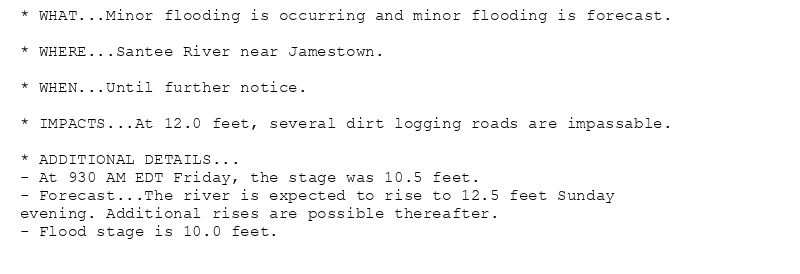
* WHAT...Minor flooding is occurring and minor flooding is forecast.
* WHERE...Santee River near Jamestown.
* WHEN...Until further notice.
* IMPACTS...At 12.0 feet, several dirt logging roads are impassable.
* ADDITIONAL DETAILS...
- At 930 AM EDT Friday, the stage was 10.5 feet.
- Forecast...The river is expected to rise to 12.5 feet Sunday
evening. Additional rises are possible thereafter.
- Flood stage is 10.0 feet.
🚨 Flood Warning issued August 15 at 10:44AM EDT by NWS Charleston SC 🚨
Additional Details Here.
15.08.2025 15:00 — 👍 0 🔁 0 💬 0 📌 0
CHS continues Flood Warning for Santee River near Jamestown [SC] until further notice
at Fri, 15 Aug 2025 14:45:23 +0000 via IEMbot
Additional Details Here.
15.08.2025 14:46 — 👍 0 🔁 0 💬 0 📌 0
CHS issues Hazardous Weather Outlook (HWO) at Aug 15, 5:39 AM EDT
at Fri, 15 Aug 2025 09:41:20 +0000 via IEMbot
Additional Details Here.
15.08.2025 09:46 — 👍 0 🔁 0 💬 0 📌 0
CHS issues Area Forecast Discussion (AFD) at Aug 15, 5:42 AM EDT
at Fri, 15 Aug 2025 09:42:22 +0000 via IEMbot
Additional Details Here.
15.08.2025 09:46 — 👍 0 🔁 0 💬 0 📌 0
CHS issues Area Forecast Discussion (AFD) at Aug 15, 1:56 AM EDT
at Fri, 15 Aug 2025 05:58:14 +0000 via IEMbot
Additional Details Here.
15.08.2025 06:06 — 👍 0 🔁 0 💬 0 📌 0