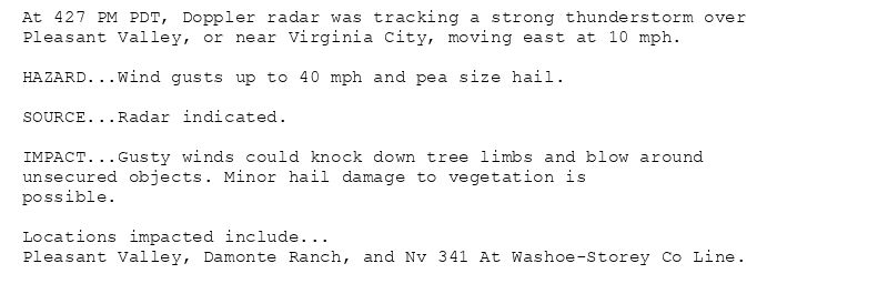
At 427 PM PDT, Doppler radar was tracking a strong thunderstorm over
Pleasant Valley, or near Virginia City, moving east at 10 mph.
HAZARD...Wind gusts up to 40 mph and pea size hail.
SOURCE...Radar indicated.
IMPACT...Gusty winds could knock down tree limbs and blow around
unsecured objects. Minor hail damage to vegetation is
possible.
Locations impacted include...
Pleasant Valley, Damonte Ranch, and Nv 341 At Washoe-Storey Co Line.
Special Weather Statement issued August 12 at 4:27PM PDT by NWS Reno NV
Additional Details Here.
12.08.2025 23:30 — 👍 0 🔁 0 💬 0 📌 0
REV issues A STRONG THUNDERSTORM WILL IMPACT STOREY AND SOUTH CENTRAL WASHOE COUNTIES THROUGH 445 PM PDT [wind: 40 MPH, hail: 0.25 IN] for Greater Reno-Carson City-Minden Area [NV... at Tue, 12 Aug 2025 23:27:52 +0000 via IEMbot
Additional Details Here.
12.08.2025 23:28 — 👍 0 🔁 0 💬 0 📌 0
REV updates Severe Thunderstorm Warning [wind: 60 MPH (RADAR INDICATED), hail: 1.00 IN (RADAR INDICATED)] (cancels Plumas [CA], continues Lassen, Sierra [CA] and Washoe [NV]) till ... at Tue, 12 Aug 2025 22:48:53 +0000 via IEMbot
Additional Details Here.
12.08.2025 23:08 — 👍 0 🔁 0 💬 0 📌 0
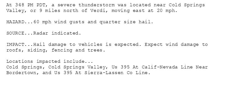
At 348 PM PDT, a severe thunderstorm was located near Cold Springs
Valley, or 9 miles north of Verdi, moving east at 20 mph.
HAZARD...60 mph wind gusts and quarter size hail.
SOURCE...Radar indicated.
IMPACT...Hail damage to vehicles is expected. Expect wind damage to
roofs, siding, fencing and trees.
Locations impacted include...
Cold Springs, Cold Springs Valley, Us 395 At Calif-Nevada Line Near
Bordertown, and Us 395 At Sierra-Lassen Co Line.
🚨 Severe Thunderstorm Warning issued August 12 at 3:48PM PDT until August 12 at 4:15PM PDT by NWS Reno NV 🚨
Additional Details Here.
12.08.2025 23:00 — 👍 0 🔁 0 💬 0 📌 0
REV issues Severe Thunderstorm Warning [wind: 60 MPH (RADAR INDICATED), hail: 1.00 IN (RADAR INDICATED)] for Lassen, Plumas, Sierra [CA] and Washoe [NV] till 4:15 PM PDT
at Tue, 1... at Tue, 12 Aug 2025 22:41:19 +0000 via IEMbot
Additional Details Here.
12.08.2025 22:48 — 👍 0 🔁 0 💬 0 📌 0
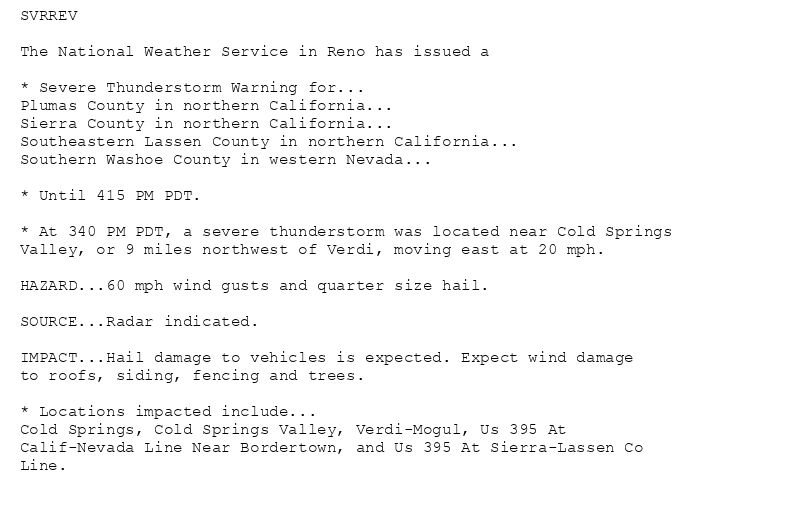
SVRREV
The National Weather Service in Reno has issued a
* Severe Thunderstorm Warning for...
Plumas County in northern California...
Sierra County in northern California...
Southeastern Lassen County in northern California...
Southern Washoe County in western Nevada...
* Until 415 PM PDT.
* At 340 PM PDT, a severe thunderstorm was located near Cold Springs
Valley, or 9 miles northwest of Verdi, moving east at 20 mph.
HAZARD...60 mph wind gusts and quarter size hail.
SOURCE...Radar indicated.
IMPACT...Hail damage to vehicles is expected. Expect wind damage
to roofs, siding, fencing and trees.
* Locations impacted include...
Cold Springs, Cold Springs Valley, Verdi-Mogul, Us 395 At
Calif-Nevada Line Near Bordertown, and Us 395 At Sierra-Lassen Co
Line.
🚨 Severe Thunderstorm Warning issued August 12 at 3:41PM PDT until August 12 at 4:15PM PDT by NWS Reno NV 🚨
Additional Details Here.
12.08.2025 22:45 — 👍 0 🔁 0 💬 0 📌 0
REV issues A STRONG THUNDERSTORM WILL IMPACT ALPINE AND DOUGLAS COUNTIES THROUGH 330 PM PDT [wind: 40 MPH, hail: 0.25 IN] for Greater Lake Tahoe Area [CA] and Greater Lake Tahoe A... at Tue, 12 Aug 2025 21:56:38 +0000 via IEMbot
Additional Details Here.
12.08.2025 22:08 — 👍 1 🔁 0 💬 0 📌 0
At 256 PM PDT, Doppler radar was tracking a strong thunderstorm near
Alpine Village, or 8 miles south of Gardnerville, moving north at 10
mph.
HAZARD...Wind gusts up to 40 mph and pea size hail.
SOURCE...Radar indicated.
IMPACT...Gusty winds could knock down tree limbs and blow around
unsecured objects. Minor hail damage to vegetation is
possible.
Locations impacted include...
Gardnerville, Gardnerville Ranchos, Woodfords, Mesa Vista, Alpine
Village, Junction U.S 395 And NV 756, Gardnerville Ranch, Indian
Creek Campground, Paynesville, Junction Nv 88 And Nv 756, Junction Nv
88 And Nv 206, Indian Creek Reservoir, Alpine County Airport, and
Junction CA 88 And NV 88.
Special Weather Statement issued August 12 at 2:56PM PDT by NWS Reno NV
Additional Details Here.
12.08.2025 22:00 — 👍 0 🔁 0 💬 0 📌 0
REV issues Area Forecast Discussion (AFD) at Aug 12, 1:55 PM PDT
at Tue, 12 Aug 2025 20:56:00 +0000 via IEMbot
Additional Details Here.
12.08.2025 21:08 — 👍 0 🔁 0 💬 0 📌 0
* WHAT...High temperatures today ranging from 99-104 degrees in
valleys and basins, with warmest lows Wednesday morning between
64-70 degrees. Widespread Moderate to locally Major HeatRisk.
* WHERE...In California, Lassen-Eastern Plumas-Eastern Sierra
Counties and Surprise Valley California. In Nevada, Northern
Washoe County, Western Nevada Basin and Range including Pyramid
Lake, Greater Reno-Carson City-Minden Area, and Mineral and
Southern Lyon Counties.
* WHEN...Until 9 AM PDT Wednesday.
* IMPACTS...Heat-related illnesses will be more likely, especially
for those spending extended periods outdoors, in poorly cooled
indoor spaces, or who are sensitive to heat.
* ADDITIONAL DETAILS...Hottest conditions are expected Tuesday
afternoon in lower valleys and basins. Cooler conditions above
4500 ft in Lassen-Eastern Plumas-Eastern Sierra counties and along
foothill slopes outside the lower valleys.
Heat Advisory issued August 12 at 1:22PM PDT until August 13 at 9:00AM PDT by NWS Reno NV
Additional Details Here.
12.08.2025 20:30 — 👍 0 🔁 0 💬 0 📌 0
REV continues Heat Advisory for Lassen-Eastern Plumas-Eastern Sierra Counties, Surprise Valley California [CA] and Greater Reno-Carson City-Minden Area, Mineral and Southern Lyon C... at Tue, 12 Aug 2025 20:22:50 +0000 via IEMbot
Additional Details Here.
12.08.2025 20:28 — 👍 0 🔁 0 💬 0 📌 0
REV issues Area Forecast Discussion (AFD) at Aug 12, 1:31 AM PDT
at Tue, 12 Aug 2025 08:31:15 +0000 via IEMbot
Additional Details Here.
12.08.2025 08:48 — 👍 0 🔁 0 💬 0 📌 0
The Storm Prediction Center issues Day 2 Isolated Dry Thunderstorm Fire Weather Risk at Aug 12, 7:00z for portions of REV
at Tue, 12 Aug 2025 07:01:04 +0000 via IEMbot
Additional Details Here.
12.08.2025 07:08 — 👍 0 🔁 0 💬 0 📌 0
SOUTH LAKE TAHOE CA Aug 11
Climate Report:
High: 88
Low: 45
Precip: 0.0"
Snow: Missing
at Tue, 12 Aug 2025 00:51:51 +0000 via IEMbot
Additional Details Here.
12.08.2025 01:08 — 👍 1 🔁 0 💬 0 📌 0
REV issues Area Forecast Discussion (AFD) at Aug 11, 1:44 PM PDT
at Mon, 11 Aug 2025 20:45:54 +0000 via IEMbot
Additional Details Here.
11.08.2025 20:48 — 👍 0 🔁 0 💬 0 📌 0
REV continues Heat Advisory for Lassen-Eastern Plumas-Eastern Sierra Counties, Surprise Valley California [CA] and Greater Reno-Carson City-Minden Area, Mineral and Southern Lyon C... at Mon, 11 Aug 2025 18:59:47 +0000 via IEMbot
Additional Details Here.
11.08.2025 19:08 — 👍 1 🔁 0 💬 0 📌 0
* WHAT...High temperatures ranging from 97-104 degrees in valleys
and basins, with warmest lows between 65-70 degrees. Widespread
Moderate to locally Major HeatRisk.
* WHERE...In California, Lassen-Eastern Plumas-Eastern Sierra
Counties and Surprise Valley California. In Nevada, Northern
Washoe County, Western Nevada Basin and Range including Pyramid
Lake, Greater Reno-Carson City-Minden Area, and Mineral and
Southern Lyon Counties.
* WHEN...Until 9 AM PDT Wednesday.
* IMPACTS...Heat-related illnesses will be more likely, especially
for those spending extended periods outdoors, in poorly cooled
indoor spaces, or who are sensitive to heat.
* ADDITIONAL DETAILS...Hottest conditions are expected Tuesday
afternoon in lower valleys and basins. Cooler conditions above
4500 ft in Lassen-Eastern Plumas-Eastern Sierra counties and along
foothill slopes outside the lower valleys.
Heat Advisory issued August 11 at 11:59AM PDT until August 13 at 9:00AM PDT by NWS Reno NV
Additional Details Here.
11.08.2025 19:00 — 👍 0 🔁 0 💬 0 📌 0
* WHAT...High temperatures ranging from 97-104 degrees in valleys
and basins, with warmest lows between 65-70 degrees. Widespread
Moderate to locally Major HeatRisk.
* WHERE...In California, Lassen-Eastern Plumas-Eastern Sierra
Counties and Surprise Valley California. In Nevada, Northern
Washoe County, Western Nevada Basin and Range including Pyramid
Lake, Greater Reno-Carson City-Minden Area, and Mineral and
Southern Lyon Counties.
* WHEN...From 11 AM this morning to 9 AM PDT Wednesday.
* IMPACTS...Heat-related illnesses will be more likely, especially
for those spending extended periods outdoors, in poorly cooled
indoor spaces, or who are sensitive to heat.
* ADDITIONAL DETAILS...Hottest conditions are expected Tuesday
afternoon in lower valleys and basins. Cooler conditions above
4500 ft in Lassen-Eastern Plumas-Eastern Sierra counties and along
foothill slopes outside the lower valleys.
Heat Advisory issued August 11 at 3:18AM PDT until August 13 at 9:00AM PDT by NWS Reno NV
Additional Details Here.
11.08.2025 10:30 — 👍 0 🔁 0 💬 0 📌 0
REV continues Heat Advisory valid at Aug 11, 11:00 AM PDT for Lassen-Eastern Plumas-Eastern Sierra Counties, Surprise Valley California [CA] and Greater Reno-Carson City-Minden Are... at Mon, 11 Aug 2025 10:19:02 +0000 via IEMbot
Additional Details Here.
11.08.2025 10:28 — 👍 0 🔁 0 💬 0 📌 0
SOUTH LAKE TAHOE CA Aug 10
Climate Report:
High: 86
Low: 45
Precip: 0.0"
Snow: Missing
at Mon, 11 Aug 2025 08:53:13 +0000 via IEMbot
Additional Details Here.
11.08.2025 09:08 — 👍 0 🔁 0 💬 0 📌 0
REV issues Area Forecast Discussion (AFD) at Aug 11, 1:43 AM PDT
at Mon, 11 Aug 2025 08:43:12 +0000 via IEMbot
Additional Details Here.
11.08.2025 08:48 — 👍 0 🔁 0 💬 0 📌 0
RENO-TAHOE INTL AIRPORT NV Aug 10
Climate Report:
High: 97
Low: 62
Precip: 0.0"
Snow: 0.0" Snow Depth: 0"
at Mon, 11 Aug 2025 00:45:35 +0000 via IEMbot
Additional Details Here.
11.08.2025 00:48 — 👍 0 🔁 0 💬 0 📌 0
REV issues Area Forecast Discussion (AFD) at Aug 10, 11:58 AM PDT
at Sun, 10 Aug 2025 18:58:39 +0000 via IEMbot
Additional Details Here.
10.08.2025 19:08 — 👍 0 🔁 0 💬 0 📌 0
* WHAT...High temperatures ranging from 95-105 degrees in valleys
and basins, with warmest lows between 65-72 degrees. Widespread
Moderate to locally Major HeatRisk.
* WHERE...In California, Lassen-Eastern Plumas-Eastern Sierra
Counties and Surprise Valley California. In Nevada, Northern
Washoe County, Western Nevada Basin and Range including Pyramid
Lake, Greater Reno-Carson City-Minden Area, and Mineral and
Southern Lyon Counties.
* WHEN...From 11 AM Monday to 9 AM PDT Wednesday.
* IMPACTS...Heat-related illnesses will be more likely, especially
for those spending extended periods outdoors, in poorly cooled
indoor spaces, or who are sensitive to heat.
* ADDITIONAL DETAILS...Hottest conditions are expected Tuesday
afternoon in lower valleys and basins. Cooler conditions above
4500 ft in Lassen-Eastern Plumas-Eastern Sierra counties and along
foothill slopes outside the lower valleys.
Heat Advisory issued August 10 at 10:26AM PDT until August 13 at 9:00AM PDT by NWS Reno NV
Additional Details Here.
10.08.2025 17:30 — 👍 0 🔁 0 💬 0 📌 0
REV issues Heat Advisory valid at Aug 11, 11:00 AM PDT for Lassen-Eastern Plumas-Eastern Sierra Counties, Surprise Valley California [CA] and Greater Reno-Carson City-Minden Area, ... at Sun, 10 Aug 2025 17:26:41 +0000 via IEMbot
Additional Details Here.
10.08.2025 17:28 — 👍 0 🔁 0 💬 0 📌 0
REV issues Area Forecast Discussion (AFD) at Aug 10, 2:52 AM PDT
at Sun, 10 Aug 2025 09:52:54 +0000 via IEMbot
Additional Details Here.
10.08.2025 10:08 — 👍 0 🔁 0 💬 0 📌 0
SOUTH LAKE TAHOE CA Aug 9
Climate Report:
High: 84
Low: 44
Precip: 0.0"
Snow: Missing
at Sun, 10 Aug 2025 09:33:54 +0000 via IEMbot
Additional Details Here.
10.08.2025 09:48 — 👍 0 🔁 0 💬 0 📌 0
SOUTH LAKE TAHOE CA Aug 9
Climate Report:
High: 84
Low: 44
Precip: 0.0"
Snow: Missing
at Sun, 10 Aug 2025 00:35:39 +0000 via IEMbot
Additional Details Here.
10.08.2025 00:48 — 👍 0 🔁 0 💬 0 📌 0
REV issues Area Forecast Discussion (AFD) at Aug 9, 4:55 PM PDT
at Sat, 09 Aug 2025 23:55:58 +0000 via IEMbot
Additional Details Here.
10.08.2025 00:08 — 👍 0 🔁 0 💬 0 📌 0
REV issues Area Forecast Discussion (AFD) at Aug 9, 11:54 AM PDT
at Sat, 09 Aug 2025 18:54:47 +0000 via IEMbot
Additional Details Here.
09.08.2025 19:08 — 👍 0 🔁 0 💬 0 📌 0