DVN issues Area Forecast Discussion (AFD) at Aug 12, 2:49 PM CDT
at Tue, 12 Aug 2025 19:49:43 +0000 via IEMbot
Additional Details Here.
12.08.2025 20:08 — 👍 1 🔁 0 💬 0 📌 0
DVN issues Area Forecast Discussion (AFD) at Aug 12, 12:31 PM CDT
at Tue, 12 Aug 2025 17:31:44 +0000 via IEMbot
Additional Details Here.
12.08.2025 17:48 — 👍 0 🔁 0 💬 0 📌 0
DVN extends time of Flood Warning for Wapsipinicon River near De Witt 4S [IA] till Aug 15, 3:00 AM CDT
at Tue, 12 Aug 2025 14:52:19 +0000 via IEMbot
Additional Details Here.
12.08.2025 15:08 — 👍 0 🔁 0 💬 0 📌 0
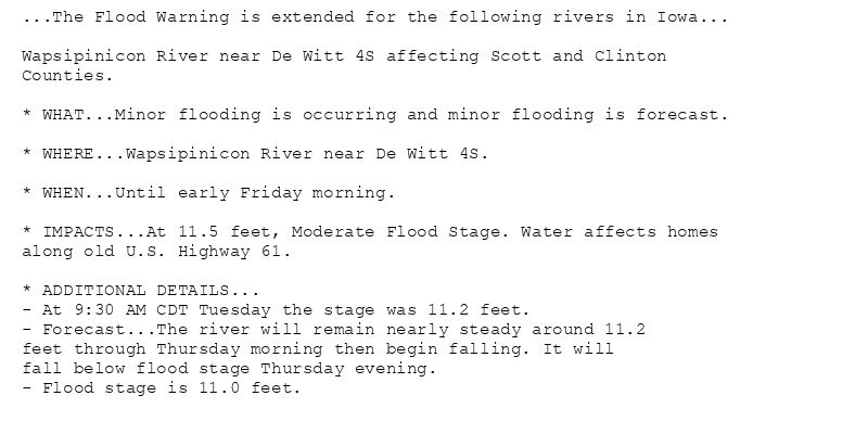
...The Flood Warning is extended for the following rivers in Iowa...
Wapsipinicon River near De Witt 4S affecting Scott and Clinton
Counties.
* WHAT...Minor flooding is occurring and minor flooding is forecast.
* WHERE...Wapsipinicon River near De Witt 4S.
* WHEN...Until early Friday morning.
* IMPACTS...At 11.5 feet, Moderate Flood Stage. Water affects homes
along old U.S. Highway 61.
* ADDITIONAL DETAILS...
- At 9:30 AM CDT Tuesday the stage was 11.2 feet.
- Forecast...The river will remain nearly steady around 11.2
feet through Thursday morning then begin falling. It will
fall below flood stage Thursday evening.
- Flood stage is 11.0 feet.
🚨 Flood Warning issued August 12 at 9:52AM CDT until August 15 at 3:00AM CDT by NWS Quad Cities IA IL 🚨
Additional Details Here.
12.08.2025 15:00 — 👍 0 🔁 0 💬 0 📌 0
1 S Muscatine [Muscatine Co, IA] Public reports Tstm Wnd Dmg at 1:44 AM CDT -- Large tree snapped near base with several other tree branches down at Kent Stein Park. Time estimated... at Tue, 12 Aug 2025 14:21:09 +0000 via IEMbot
Additional Details Here.
12.08.2025 14:28 — 👍 0 🔁 0 💬 0 📌 0
3 ENE Garden Plain [Whiteside Co, IL] Trained Spotter reports Tstm Wnd Dmg at 3:00 AM CDT -- Approximately 12 inch oak tree fell on outbuilding.
at Tue, 12 Aug 2025 13:04:26 +0000 via IEMbot
Additional Details Here.
12.08.2025 13:08 — 👍 1 🔁 0 💬 0 📌 0
DVN issues Patchy Dense Fog For the Morning Commute for Benton, Buchanan, Iowa, Jefferson, Johnson, Keokuk, Linn, Van Buren, Washington [IA] till 9:15 AM CDT
at Tue, 12 Aug 2025 12:09:32 +0000 via IEMbot
Additional Details Here.
12.08.2025 12:28 — 👍 1 🔁 0 💬 0 📌 0
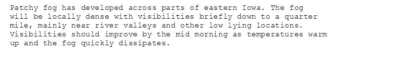
Patchy fog has developed across parts of eastern Iowa. The fog
will be locally dense with visibilities briefly down to a quarter
mile, mainly near river valleys and other low lying locations.
Visibilities should improve by the mid morning as temperatures warm
up and the fog quickly dissipates.
Special Weather Statement issued August 12 at 7:09AM CDT by NWS Quad Cities IA IL
Additional Details Here.
12.08.2025 12:15 — 👍 0 🔁 0 💬 0 📌 0
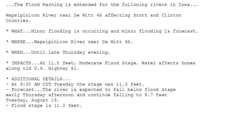
...The Flood Warning is extended for the following rivers in Iowa...
Wapsipinicon River near De Witt 4S affecting Scott and Clinton
Counties.
* WHAT...Minor flooding is occurring and minor flooding is forecast.
* WHERE...Wapsipinicon River near De Witt 4S.
* WHEN...Until late Thursday evening.
* IMPACTS...At 11.5 feet, Moderate Flood Stage. Water affects homes
along old U.S. Highway 61.
* ADDITIONAL DETAILS...
- At 6:30 AM CDT Tuesday the stage was 11.3 feet.
- Forecast...The river is expected to fall below flood stage
early Thursday afternoon and continue falling to 8.7 feet
Tuesday, August 19.
- Flood stage is 11.0 feet.
🚨 Flood Warning issued August 12 at 7:12AM CDT until August 14 at 9:00PM CDT by NWS Quad Cities IA IL 🚨
Additional Details Here.
12.08.2025 12:15 — 👍 0 🔁 0 💬 0 📌 0
3 NNE Cedar Rapids [Linn Co, IA] Trained Spotter reports Rain of 1.11 Inch at 6:10 AM CDT -- Since midnight.
at Tue, 12 Aug 2025 11:19:06 +0000 via IEMbot
Additional Details Here.
12.08.2025 11:28 — 👍 0 🔁 0 💬 0 📌 0
DVN issues Area Forecast Discussion (AFD) at Aug 12, 5:54 AM CDT ...12z Aviation Update... via IEMbot
Additional Details Here.
12.08.2025 11:08 — 👍 0 🔁 0 💬 0 📌 0
Parnell [Iowa Co, IA] Trained Spotter reports Rain of 2.20 Inch at 5:00 AM CDT -- Rainfall in past 12 hours.
at Tue, 12 Aug 2025 10:17:00 +0000 via IEMbot
Additional Details Here.
12.08.2025 10:28 — 👍 0 🔁 0 💬 0 📌 0
DVN issues Hazardous Weather Outlook (HWO) at Aug 12, 4:27 AM CDT
at Tue, 12 Aug 2025 09:28:51 +0000 via IEMbot
Additional Details Here.
12.08.2025 09:48 — 👍 0 🔁 0 💬 0 📌 0
DVN issues Special Weather Statement [wind: 50 MPH, hail: 0.00 IN] for Dubuque, Jackson [IA] and Carroll, Jo Daviess, Stephenson, Whiteside [IL] till 4:15 AM CDT
at Tue, 12 Aug 2025 08:37:55 +0000 via IEMbot
Additional Details Here.
12.08.2025 08:48 — 👍 0 🔁 0 💬 0 📌 0
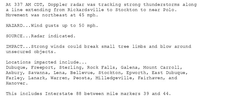
At 337 AM CDT, Doppler radar was tracking strong thunderstorms along
a line extending from Rickardsville to Stockton to near Polo.
Movement was northeast at 45 mph.
HAZARD...Wind gusts up to 50 mph.
SOURCE...Radar indicated.
IMPACT...Strong winds could break small tree limbs and blow around
unsecured objects.
Locations impacted include...
Dubuque, Freeport, Sterling, Rock Falls, Galena, Mount Carroll,
Asbury, Savanna, Lena, Bellevue, Stockton, Epworth, East Dubuque,
Farley, Lanark, Warren, Peosta, Milledgeville, Fairhaven, and
Hanover.
This includes Interstate 88 between mile markers 39 and 44.
Special Weather Statement issued August 12 at 3:37AM CDT by NWS Quad Cities IA IL
Additional Details Here.
12.08.2025 08:45 — 👍 0 🔁 0 💬 0 📌 0
DVN issues Area Forecast Discussion (AFD) at Aug 12, 3:11 AM CDT
at Tue, 12 Aug 2025 08:11:59 +0000 via IEMbot
Additional Details Here.
12.08.2025 08:28 — 👍 0 🔁 0 💬 0 📌 0
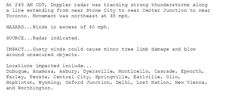
At 245 AM CDT, Doppler radar was tracking strong thunderstorms along
a line extending from near Stone City to near Center Junction to near
Toronto. Movement was northeast at 45 mph.
HAZARD...Winds in excess of 40 mph.
SOURCE...Radar indicated.
IMPACT...Gusty winds could cause minor tree limb damage and blow
around unsecured objects.
Locations impacted include...
Dubuque, Anamosa, Asbury, Dyersville, Monticello, Cascade, Epworth,
Farley, Peosta, Central City, Springville, Earlville, Olin,
Hopkinton, Wyoming, Oxford Junction, Delhi, Lost Nation, New Vienna,
and Worthington.
Special Weather Statement issued August 12 at 2:45AM CDT by NWS Quad Cities IA IL
Additional Details Here.
12.08.2025 08:00 — 👍 1 🔁 0 💬 0 📌 0
DVN issues Special Weather Statement [wind: 40 MPH, hail: 0.00 IN] for Cedar, Clinton, Delaware, Dubuque, Jackson, Jones, Linn [IA] till 3:30 AM CDT
at Tue, 12 Aug 2025 07:45:39 +0000 via IEMbot
Additional Details Here.
12.08.2025 07:48 — 👍 0 🔁 0 💬 0 📌 0
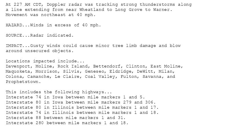
At 227 AM CDT, Doppler radar was tracking strong thunderstorms along
a line extending from near Wheatland to Long Grove to Warner.
Movement was northeast at 40 mph.
HAZARD...Winds in excess of 40 mph.
SOURCE...Radar indicated.
IMPACT...Gusty winds could cause minor tree limb damage and blow
around unsecured objects.
Locations impacted include...
Davenport, Moline, Rock Island, Bettendorf, Clinton, East Moline,
Maquoketa, Morrison, Silvis, Geneseo, Eldridge, DeWitt, Milan,
Colona, Camanche, Le Claire, Coal Valley, Fulton, Savanna, and
Prophetstown.
This includes the following highways...
Interstate 74 in Iowa between mile markers 1 and 5.
Interstate 80 in Iowa between mile markers 279 and 306.
Interstate 80 in Illinois between mile markers 1 and 17.
Interstate 74 in Illinois between mile markers 1 and 18.
Interstate 88 between mile markers 1 and 31.
Interstate 280 between mile markers 1 and 18.
Special Weather Statement issued August 12 at 2:27AM CDT by NWS Quad Cities IA IL
Additional Details Here.
12.08.2025 07:30 — 👍 0 🔁 0 💬 0 📌 0
DVN issues Special Weather Statement [wind: 40 MPH, hail: 0.00 IN] for Cedar, Clinton, Jackson, Muscatine, Scott [IA] and Carroll, Henry, Rock Island, Whiteside [IL] till 3:15 AM ... at Tue, 12 Aug 2025 07:28:04 +0000 via IEMbot
Additional Details Here.
12.08.2025 07:28 — 👍 0 🔁 0 💬 0 📌 0
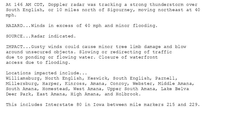
At 146 AM CDT, Doppler radar was tracking a strong thunderstorm over
South English, or 10 miles north of Sigourney, moving northeast at 40
mph.
HAZARD...Winds in excess of 40 mph and minor flooding.
SOURCE...Radar indicated.
IMPACT...Gusty winds could cause minor tree limb damage and blow
around unsecured objects. Slowing or redirecting of traffic
due to ponding or flowing water. Closure of waterfront
access due to flooding.
Locations impacted include...
Williamsburg, North English, Keswick, South English, Parnell,
Millersburg, Harper, Kinross, Amana, Conroy, Webster, Middle Amana,
South Amana, Homestead, West Amana, Upper South Amana, Lake Belva
Deer Park, East Amana, High Amana, and Holbrook.
This includes Interstate 80 in Iowa between mile markers 215 and 229.
Special Weather Statement issued August 12 at 1:47AM CDT by NWS Quad Cities IA IL
Additional Details Here.
12.08.2025 07:00 — 👍 0 🔁 0 💬 0 📌 0
DVN issues A strong thunderstorm will impact portions of northern Keokuk and central Iowa Counties through 230 AM CDT [wind: 40 MPH, hail: 0.00 IN]
at Tue, 12 Aug 2025 06:47:45 +0000 via IEMbot
Additional Details Here.
12.08.2025 06:48 — 👍 0 🔁 0 💬 0 📌 0
BURLINGTON IA Aug 11
Climate Report:
High: 85
Low: 67
Precip: 0.08"
Snow: Missing
at Tue, 12 Aug 2025 06:23:55 +0000 via IEMbot
Additional Details Here.
12.08.2025 06:28 — 👍 0 🔁 0 💬 0 📌 0
IOWA CITY IA Aug 11
Climate Report:
High: 81
Low: 66
Precip: 0.01"
Snow: Missing
at Tue, 12 Aug 2025 06:23:55 +0000 via IEMbot
Additional Details Here.
12.08.2025 06:28 — 👍 0 🔁 0 💬 0 📌 0
DVN issues Special Weather Statement [wind: 40 MPH, hail: 0.00 IN] for Des Moines, Henry, Jefferson, Johnson, Lee, Louisa, Muscatine, Van Buren, Washington [IA] and Henderson [IL]... at Tue, 12 Aug 2025 05:58:32 +0000 via IEMbot
Additional Details Here.
12.08.2025 06:08 — 👍 0 🔁 0 💬 0 📌 0
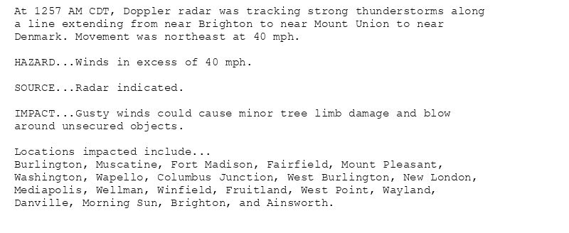
At 1257 AM CDT, Doppler radar was tracking strong thunderstorms along
a line extending from near Brighton to near Mount Union to near
Denmark. Movement was northeast at 40 mph.
HAZARD...Winds in excess of 40 mph.
SOURCE...Radar indicated.
IMPACT...Gusty winds could cause minor tree limb damage and blow
around unsecured objects.
Locations impacted include...
Burlington, Muscatine, Fort Madison, Fairfield, Mount Pleasant,
Washington, Wapello, Columbus Junction, West Burlington, New London,
Mediapolis, Wellman, Winfield, Fruitland, West Point, Wayland,
Danville, Morning Sun, Brighton, and Ainsworth.
Special Weather Statement issued August 12 at 12:58AM CDT by NWS Quad Cities IA IL
Additional Details Here.
12.08.2025 06:00 — 👍 0 🔁 0 💬 0 📌 0
DVN issues Strong thunderstorms will impact portions of Keokuk, southwestern Iowa and northwestern Jefferson Counties through 130 AM CDT [wind: 40 MPH, hail: 0.00 IN]
at Tue, 12 A... at Tue, 12 Aug 2025 05:43:47 +0000 via IEMbot
Additional Details Here.
12.08.2025 05:48 — 👍 0 🔁 0 💬 0 📌 0
At 1243 AM CDT, Doppler radar was tracking strong thunderstorms along
a line extending from 7 miles north of Ottumwa Industrial Airport to
near Maharishi Vedic City. Movement was north at 45 mph.
HAZARD...Winds in excess of 40 mph and minor flooding.
SOURCE...Radar indicated.
IMPACT...Gusty winds could cause minor tree limb damage and blow
around unsecured objects. Slowing or redirecting of traffic
due to ponding or flowing water. Closure of waterfront
access due to flooding.
Locations impacted include...
Fairfield, Sigourney, North English, Hedrick, What Cheer, Richland,
Batavia, Delta, Maharishi Vedic City, Keswick, South English,
Packwood, Parnell, Millersburg, Harper, Martinsburg, Kinross,
Hayesville, Abingdon, and Keota.
Special Weather Statement issued August 12 at 12:43AM CDT by NWS Quad Cities IA IL
Additional Details Here.
12.08.2025 05:45 — 👍 0 🔁 0 💬 0 📌 0
At 1224 AM CDT, Doppler radar was tracking line of heavy rain along a
line extending from near Kahoka to 8 miles southwest of Alexandria.
Movement was northeast at 40 mph.
HAZARD...Winds in excess of 40 mph and minor flooding.
SOURCE...Radar indicated.
IMPACT...Gusty winds could cause minor tree limb damage and blow
around unsecured objects. Slowing or redirecting of traffic
due to ponding or flowing water. Closure of waterfront
access due to flooding.
Locations impacted include...
Fort Madison, Keokuk, Kahoka, Nauvoo, Hamilton, Warsaw, West Point,
Donnellson, Montrose, Wayland, Alexandria, Ferris, Franklin, St.
Paul, Colusa, Adrian, New Boston, Niota, Denmark, and St.
Francisville.
Special Weather Statement issued August 12 at 12:24AM CDT by NWS Quad Cities IA IL
Additional Details Here.
12.08.2025 05:30 — 👍 1 🔁 0 💬 0 📌 0
DVN issues Special Weather Statement [wind: 40 MPH, hail: 0.00 IN] for Henry, Jefferson, Lee, Van Buren [IA] and Clark, Scotland [MO] till 1:00 AM CDT
at Tue, 12 Aug 2025 05:13:48 +0000 via IEMbot
Additional Details Here.
12.08.2025 05:28 — 👍 0 🔁 0 💬 0 📌 0