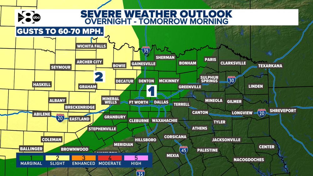
Storms coming out of OK & the TX panhandle this evening will move into North Texas overnight and tomorrow morning. The metroplex is under a marginal risk for seeing severe storms capable of producing 60 mph wind gusts. Storms will likely reach the metroplex between 6 - 9 AM.
04.08.2025 02:07 — 👍 1 🔁 0 💬 0 📌 0
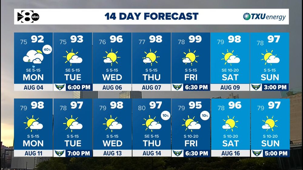
Storms are possible into your Monday but the rest of the week looks hot and dry. #txwx
04.08.2025 00:30 — 👍 1 🔁 0 💬 0 📌 0
After Monday our rain chances go away and temperatures gradually increase! #txwx
03.08.2025 22:45 — 👍 0 🔁 0 💬 0 📌 0
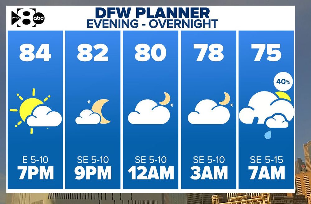
There still could be a couple of storms east of the metroplex this evening but DFW looks to stay dry until tomorrow morning. Give yourself extra time on your Monday morning commute! Storms are possible.
03.08.2025 21:37 — 👍 1 🔁 0 💬 0 📌 0
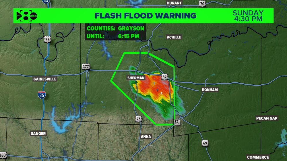
Flash Flood Warning for Grayson County until 6:15 PM. This storm has been nearly stationary near Sherman. An additional 1-2" of rainfall is possible. #txwx
03.08.2025 21:32 — 👍 0 🔁 0 💬 0 📌 0
There still could be a couple of storms east of the metroplex this evening but DFW looks to stay dry until tomorrow morning. Give yourself extra time on your Monday morning commute! Storms are possible. #txwx
03.08.2025 21:30 — 👍 1 🔁 1 💬 0 📌 0
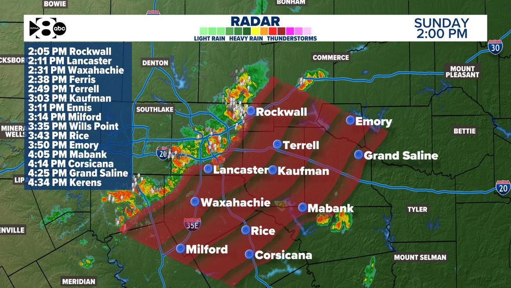
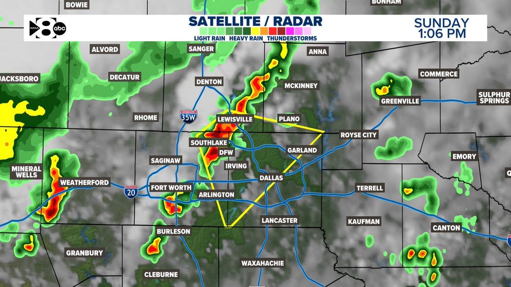
2 PM Radar Update: The line of the storms moving through the metroplex is no longer severe but could still produce wind gusts to 40 mph. These storms are moving SE at 20 mph. Here's the latest track. #TXWX
03.08.2025 19:02 — 👍 0 🔁 0 💬 0 📌 0
We still have a Severe Thunderstorm Warning over Dallas & Tarrant counties until 2 PM. This line of storms continues to weaken though as it moves SE via our Storm Strength product.
03.08.2025 18:40 — 👍 1 🔁 0 💬 0 📌 0
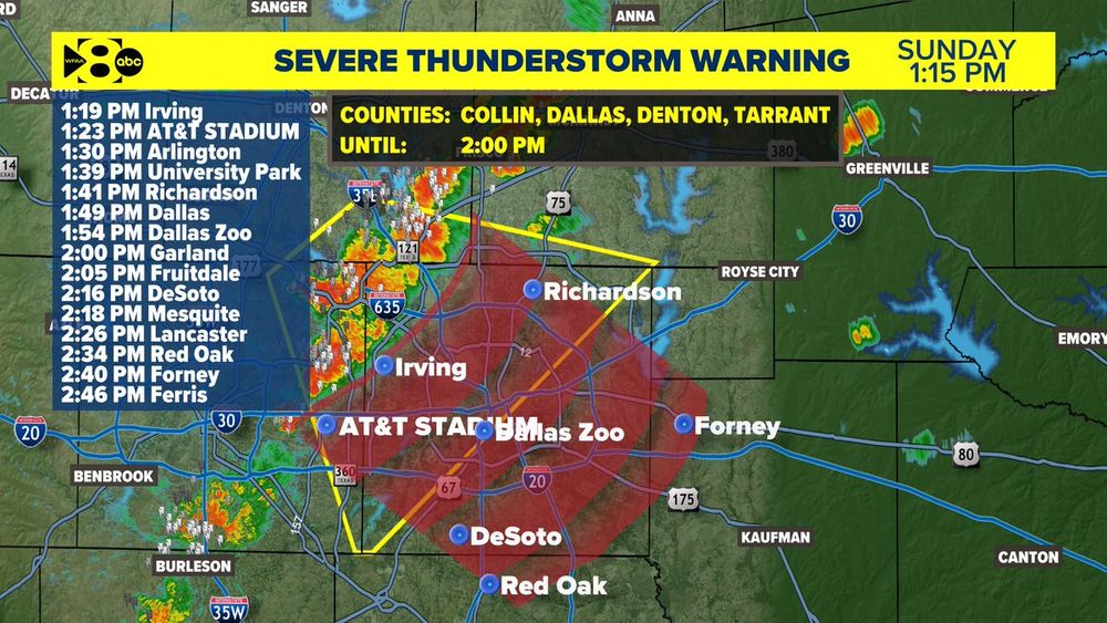
A Severe Thunderstorm Warning for Collin, Dallas, Denton, & Tarrant county has been issued until 2 PM. Quarter size hail & gusts to 60 mph possible. This storm is moving SE around 20 mph. Here's the latest track. #txwx
03.08.2025 18:18 — 👍 0 🔁 0 💬 0 📌 0
A severe thunderstorm warning has been issued for parts of Tarrant, Denton, Dallas & Collin counties until 2 p.m. Sunday. #wfaaweather
03.08.2025 18:09 — 👍 0 🔁 0 💬 0 📌 0
Severe Thunderstorm Warning for Collin, Dallas, Denton and Tarrant County until 2:00pm.
03.08.2025 18:04 — 👍 0 🔁 0 💬 0 📌 0
STORM UPDATE! Scattered strong storms continue across North Texas, especially near Denton, the NE portion of Tarrant & parts of Collin counties. Reports 40 mph downburst winds impacting Double Oak, Highland Village, Bartonville & Flower Mound. #wfaaweather
03.08.2025 18:01 — 👍 1 🔁 0 💬 0 📌 0
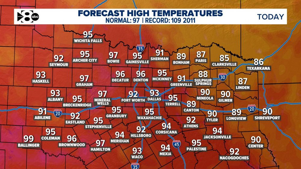
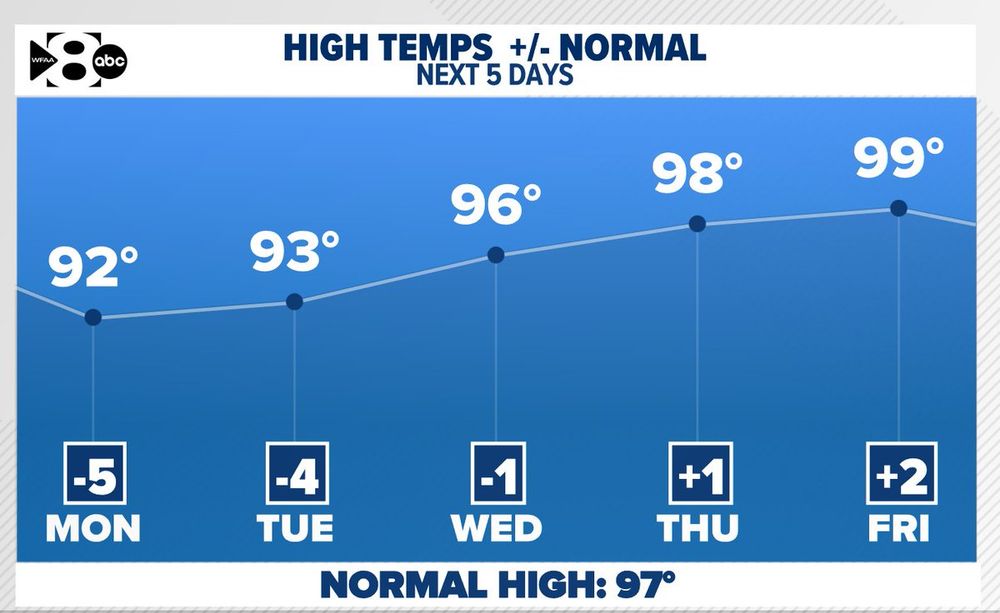
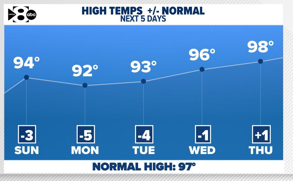
Sunday highs across North Texas will top out in the low to mid 90s, which is slightly below average for early August. DFW will reach around 92-93°, with hotter temperatures to the west of Tarrant Co. 2011 holds the record at 109° #wfaaweather
03.08.2025 15:42 — 👍 0 🔁 0 💬 0 📌 0
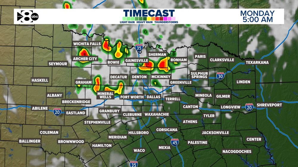
Another round of storms is expected late tonight into early Monday. Some could bring damaging winds, especially in Denton & Collin counties & west of IH-35W. Stay weather aware! #wfaaweather
03.08.2025 14:40 — 👍 0 🔁 0 💬 0 📌 0
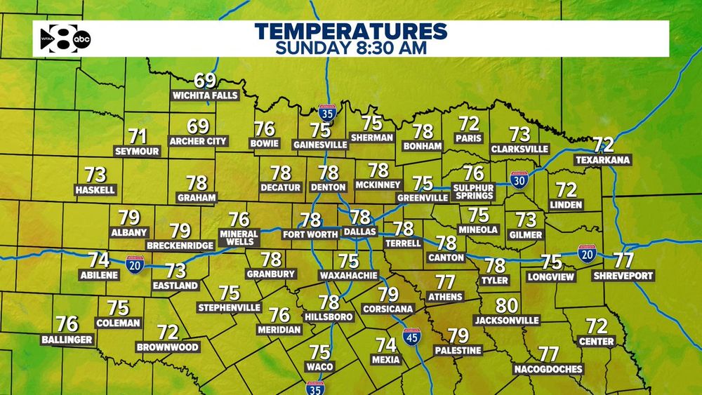
Temps are starting out in the mid to upper 70s across the region. A warm, humid start before things heat up to the low 90s this afternoon. #wfaaweather
03.08.2025 13:40 — 👍 0 🔁 0 💬 0 📌 0
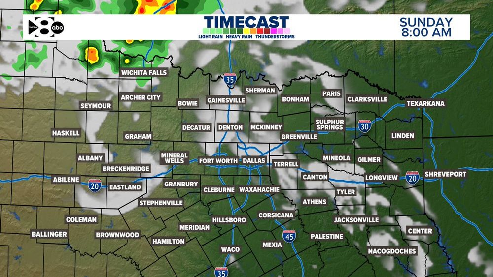
Good morning, North Texas! A weakening thunderstorm complex could bring light showers NW of DFW this morning, but most areas stay dry. Highs near 93° with a heat index around 97°. #wfaaweather
03.08.2025 13:22 — 👍 1 🔁 1 💬 0 📌 0
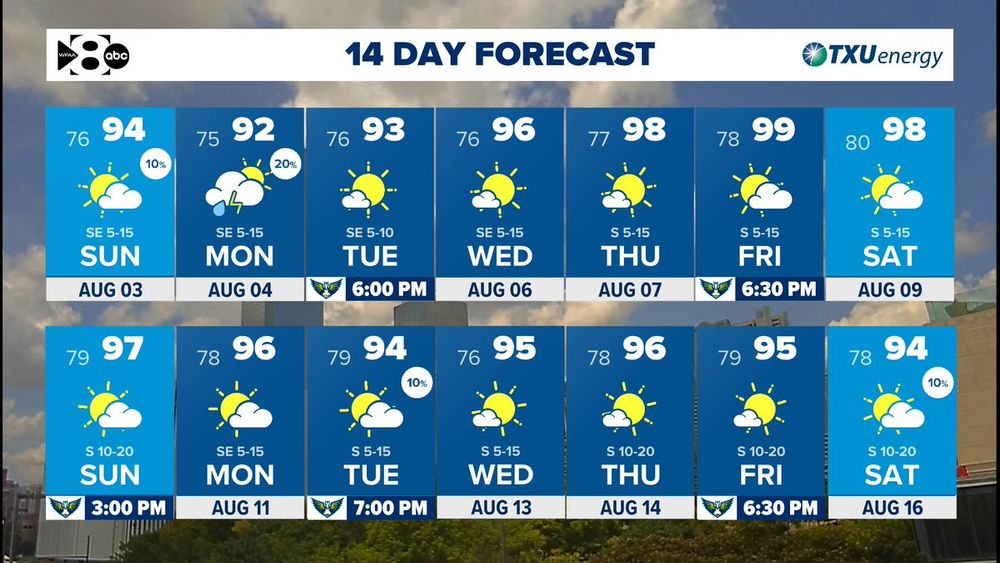
We will have a low coverage of rain through Monday with temperatures staying below normal for awhile longer! #txwx
03.08.2025 00:00 — 👍 1 🔁 0 💬 0 📌 0
We're getting a nice stretch of below normal temperatures, for now! #txwx
02.08.2025 22:45 — 👍 0 🔁 0 💬 0 📌 0
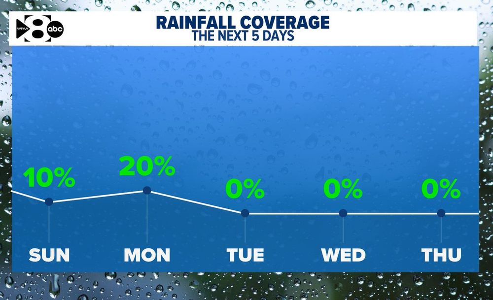
Rain chance will linger through Monday but our overall coverage will be pretty low. #txwx
02.08.2025 21:45 — 👍 0 🔁 0 💬 0 📌 0
We're staying warm this evening with skies clearing out a little more overnight tonight! #txwx
02.08.2025 20:23 — 👍 0 🔁 0 💬 0 📌 0

The actual high temps will hit the low 90s…but it will feel like 100–103° in many spots Saturday afternoon! That’s the heat index, hot temps + humidity = dangerous conditions. Hydrate, limit time outside, and check on pets & neighbors! #wfaaweather
02.08.2025 16:12 — 👍 0 🔁 0 💬 0 📌 0
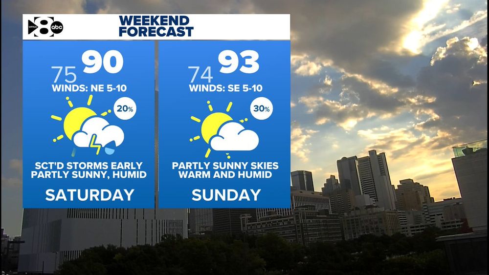
We're looking at just a 20 % shot at showers/storms on Saturday, mainly during the morning & afternoon. Rain chances increase Sunday to 30% w/ possible evening showers. Most of you will stay pretty dry through the weekend. #wfaaweather
02.08.2025 13:26 — 👍 1 🔁 0 💬 0 📌 0
Heading outside around 8 AM? Expect warm and sticky: about 76° across the metroplex with high humidity, thanks to partly cloudy skies. Feels more like 80° even in the shade. Very mild winds aren't helping. #wfaaweather
02.08.2025 12:36 — 👍 1 🔁 1 💬 0 📌 0
Interactive Weather Radar | Dallas, Texas | wfaa.com
Dallas interactive weather radar from WFAA in Dallas, Texas
10:20pm update: Storm coverage has lowered across North Texas. There are no active watches or warnings. Rain is mainly east of DFW.
http://wfaa.com/radar
#wfaaweather
02.08.2025 03:25 — 👍 0 🔁 0 💬 0 📌 0
9pm update: Non-severe storms have developed in eastern/southeastern Dallas Co. Heavy rain and gusty winds (up to 40 mph) will be possible. The overall severe threat remains low. #wfaaweather
02.08.2025 02:02 — 👍 0 🔁 0 💬 0 📌 0
8:15pm update: Storm coverage has overall lowered across the area. A few storms remain east of DFW. Some activity is trying to start in eastern Dallas Co. Severe threat remains low.
#wfaaweather
02.08.2025 01:17 — 👍 0 🔁 0 💬 0 📌 0
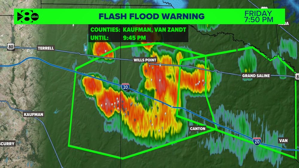
A Flash Flood Warning continues for Van Zandt County and now includes eastern parts of Kaufman County until 9:45pm. Storms here are stationary and have produced near 2.5 inches of rain. The heaviest rain will be along and south of I-20. #wfaaweather
02.08.2025 00:58 — 👍 0 🔁 0 💬 0 📌 0
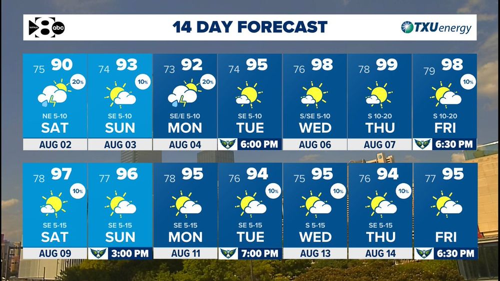
We don't want to jinx it...but no 100s on the 14 day.
FOR NOW. It'll be cooler than normal through early next week.
#wfaaweather
02.08.2025 00:00 — 👍 0 🔁 0 💬 0 📌 0
Interactive Weather Radar | Dallas, Texas | wfaa.com
Dallas interactive weather radar from WFAA in Dallas, Texas
6:30pm update: Watching a few outflows this evening. If storms develop north of the stationary front, it'll be along the outflows.
Right now, it is simply a gust of wind. #wfaaweather
http://wfaa.com/radar
01.08.2025 23:37 — 👍 0 🔁 0 💬 0 📌 0
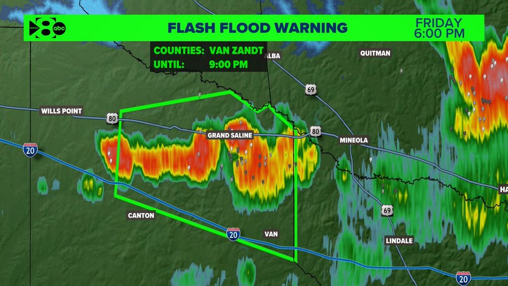
A Flash Flood Warning has been issued for Van Zandt County until 9PM. Over 3 inches of rain has fallen in the past hour and more is on the way. This includes the towns of Grand Saline, Van and Edgewood #wfaaweather
01.08.2025 23:06 — 👍 1 🔁 0 💬 0 📌 0