Saw this on a map's Avatar

Saw this on a map

@stuartackland.bsky.social

From crazy cartouches, wonderful beasts or general carto-frippery, a site that highlights the non-map part of maps! From the Map team at the Bodleian Library

535 Followers  |  2 Following  |  84 Posts  |  Joined: 18.11.2024  |  1.6567

Latest posts by stuartackland.bsky.social on Bluesky

Post image Post image Post image Post image

OTD 1740 this map was printed, possibly on one of the printing presses shown on the map, to celebrate a 'Frost Fayre' on the Thames, which had been frozen all winter. The ice was thick enough for games such as nine pins to be played or an ox to be roasted. Cold indeed. @bodleian.ox.ac.uk

09.02.2026 09:17 β€” πŸ‘ 5    πŸ” 1    πŸ’¬ 0    πŸ“Œ 0
Post image

In Speed's atlas, 1611, is this image, with text 'But success of warr altering Maud the Emperese to save her owne life adventured to throwe the host her enimie, layde in a coffin fayned to be dead, and soe was carryed in a horse litter from Winchester'. Maud's escape was in 1141 @bodleian.ox.ac.uk

29.01.2026 16:11 β€” πŸ‘ 6    πŸ” 2    πŸ’¬ 0    πŸ“Œ 0
Post image Post image Post image

'Birdstrikes can ruin your whole day and most of your aircraft'. Probably not much fun for the bird either. These warnings from Falkland Island maps made during and after the 1982 war show how the war and post-war reconstruction had to coexist with the animal life on the islands @bodleian.ox.ac.uk

23.01.2026 09:44 β€” πŸ‘ 4    πŸ” 2    πŸ’¬ 0    πŸ“Œ 0
Post image

It's Penguin Appreciation day today, here's one of the earliest we can find on a map, from John Senex's 'South America corrected from the observations comunicated to the Royal Society’s of London & Paris', 1710. More on the map here blogs.bodleian.ox.ac.uk/maps/2019/02... @bodleian.ox.ac.uk

20.01.2026 11:21 β€” πŸ‘ 43    πŸ” 13    πŸ’¬ 0    πŸ“Œ 0
Post image Post image Post image

In the natural history section of an 1849 atlas of natural phenomena, 'made with the co-operation of men eminent in the different departments of science', are wonderful pictures of animals of the old and new worlds, including an unusual 'perpendicular' map of wildlife habitat @bodleian.ox.ac.uk

20.01.2026 09:09 β€” πŸ‘ 8    πŸ” 1    πŸ’¬ 0    πŸ“Œ 0

Willem Jansz Blaeu

16.01.2026 11:10 β€” πŸ‘ 1    πŸ” 0    πŸ’¬ 1    πŸ“Œ 0
Post image Post image Post image Post image

In a section in a 1639 Dutch navigational manual is a dial showing how to use a mariner's astrolabe to measure altitude at sea to find latitude. From the same volume this lovely diagram on the use of a back-staff to measure the sun's altitude @bodleian.ox.ac.uk

16.01.2026 10:09 β€” πŸ‘ 8    πŸ” 2    πŸ’¬ 1    πŸ“Œ 0
Post image

A ploughing scene also appears on this 1941 map by the artist Eric Gill to mark the signing of the Atlantic Charter between Britain and the U.S. in 1941, with a quote from the Book of Isiah, 'They shall beat their swords into plowshares...' blogs.bodleian.ox.ac.uk/maps/2019/07... @bodleian.ox.ac.uk

12.01.2026 12:09 β€” πŸ‘ 9    πŸ” 0    πŸ’¬ 0    πŸ“Œ 1
Post image

Today is Plough Monday, the first Monday after Epiphany, when agricultural labourers would start to plough the fields in preparation for sowing and planting crops. Hopefully the end result would be as beautiful as these fields, from a manuscript map of Hunsdon House, Herts, c1820 @bodleian.ox.ac.uk

12.01.2026 10:30 β€” πŸ‘ 47    πŸ” 15    πŸ’¬ 0    πŸ“Œ 3
Post image

"Who is the man who appears unexpectedly in an OS map..?"

07.01.2026 11:43 β€” πŸ‘ 823    πŸ” 167    πŸ’¬ 20    πŸ“Œ 12
Post image Post image

Where better to live at this time of year than Christmas Common? One of many Christmas locations in the World this is the one nearest to us here at the Bodleian on a map. Christmas Island, in the Indian Ocean, is probably the most famous, first seen on Christmas Day, 1643 @bodleian.ox.ac.uk

23.12.2025 09:59 β€” πŸ‘ 3    πŸ” 0    πŸ’¬ 0    πŸ“Œ 0
Post image Post image Post image

Today is International Mountain Day. Here are covers for Snowdon (1,085 metres), for a Soviet map of the Teberda region of the Caucasus mountains (over 4000 m in places) and of the Zermatt region of Switzerland with the Matterhorn, 4,478 m, on the cover. Happy climbing everyone. @bodleian.ox.ac.uk

11.12.2025 09:37 β€” πŸ‘ 23    πŸ” 8    πŸ’¬ 1    πŸ“Œ 1
Post image

A grim 'X marks the spot'. Wilson is Major Allan Wilson, who led a small unit of British South African soldiers in the 1st Matabele War. On the 3rd and 4th of December 1893 they came up against a much larger force of Matabele warriors along the Shangani River, in modern Zimbabwe. @bodleian.ox.ac.uk

02.12.2025 09:39 β€” πŸ‘ 4    πŸ” 1    πŸ’¬ 0    πŸ“Œ 0
Post image

Here's an interesting variation on D.I.Y. From a map of Europe at the start of the War, 1914, an invitation from the Financial Times to fill in boundaries based on predicted peace terms. Offered at a time when 'it will be all over by Christmas' I wonder if anyone got even close? @bodleian.ox.ac.uk

28.11.2025 10:11 β€” πŸ‘ 6    πŸ” 3    πŸ’¬ 0    πŸ“Œ 0
Post image Post image

Paul Helbronner was a French cartographer at the turn of the C19th and C20th century who specialized in maps of the Alps. He made a beautiful & long (over 620cm!) panoramic map of the view from Mont Blanc in 1921 and included his climb to the top, with his footprints in the snow @bodleian.ox.ac.uk

18.11.2025 10:18 β€” πŸ‘ 28    πŸ” 8    πŸ’¬ 0    πŸ“Œ 1

would have been me, i was here then. all that gone now

12.11.2025 16:16 β€” πŸ‘ 0    πŸ” 0    πŸ’¬ 1    πŸ“Œ 0

no, should it?

11.11.2025 16:21 β€” πŸ‘ 0    πŸ” 0    πŸ’¬ 1    πŸ“Œ 0
Post image Post image

Lots going on in this picture from a Dutch sea atlas, 1676. Figures point cross-staffs to a sea-torch, symbolizing navigation, others measure maps and globes with compasses. A sailor holds a sounding weight to measure depths and a navigator a marine astrolabe to measure latitude @bodleian.ox.ac.uk

30.10.2025 14:54 β€” πŸ‘ 5    πŸ” 1    πŸ’¬ 0    πŸ“Œ 0
Post image Post image Post image

Since the 1920s the Ordnance Survey have made maps of British historical periods, here are the covers for the 1st and 2nd editions of the Dark Ages map. The 2nd ed. features 'the first attempted reconstruction in colour' of the Sutton Hoo Saxon helmet @bodleian.ox.ac.uk @ordnancesurvey.bsky.social

28.10.2025 10:26 β€” πŸ‘ 6    πŸ” 0    πŸ’¬ 0    πŸ“Œ 0
Post image Post image

Cronos, Greek god of death and time (hence the scythe and hourglass) and Hercules (in one of his labours, capturing the multi-headed dog Cerberus) either side of an armillary sphere in a 1663 Blaeu atlas of Asia. On the next page Hercules opens a door onto the continent @bodleian.ox.ac.uk

24.10.2025 08:27 β€” πŸ‘ 4    πŸ” 2    πŸ’¬ 0    πŸ“Œ 0
Post image Post image Post image

'Close's fisherman's chart', c1922, has some beautifully poetic descriptions of fishing grounds and trawling sites, along with a timeline of U-Boats captured or destroyed in the channel during the First World War, including this piece about the activities of Skipper Tom Phillips @bodleian.ox.ac.uk

16.10.2025 10:11 β€” πŸ‘ 6    πŸ” 1    πŸ’¬ 0    πŸ“Œ 0
Post image

An exciting jousting scene in this map of Upper Saxony in 'Atlas Geographicus Major', by Johann Homann, 1759. The joust was hosted by Henry the Illustrious in 1263. Poet, composer, patron of the arts and warrior Henry is the perfect ideal of what a knight should be
@bodleian.ox.ac.uk

14.10.2025 13:02 β€” πŸ‘ 2    πŸ” 0    πŸ’¬ 0    πŸ“Œ 0
Post image

Bartomeu Olives 1575 portolan nautical chart of the Mediterranean includes a lovely elephant and the Red Sea (in red, obvs). Included is the parting of the sea created by God for Moses and the Israelites to cross, fleeing from the Egyptians, as stated in Exodus chapter 14. @bodleian.ox.ac.uk

07.10.2025 11:28 β€” πŸ‘ 12    πŸ” 4    πŸ’¬ 0    πŸ“Œ 1
Post image Post image Post image

Herman Moll's 1724 '...maps of England and Wales' are a set of county maps, and standard for the time. What sets the maps apart from others are the illustrations, be they wonderfully named caverns in the Peak District, ancient monuments or a confused approach to old fossils @bodleian.ox.ac.uk

06.10.2025 11:30 β€” πŸ‘ 4    πŸ” 1    πŸ’¬ 0    πŸ“Œ 0
Post image Post image Post image

Olaus Magnus's 1539 map of Scandinavia is full of the wonderful and the plain weird. Sea monsters and maelstroms attack ships while on land people travel in reindeer-drawn carriages and fish through the ice. The map was the first to accurately depict land and give place-names. @bodleian.ox.ac.uk

29.09.2025 08:40 β€” πŸ‘ 16    πŸ” 4    πŸ’¬ 3    πŸ“Œ 0
Post image Post image Post image

The first public railway was built 200 yrs ago this month, the Stockton and Darlington. Here's some earlier steam engines from railways maps. The Grand Junction from 1839 and the two engines images from 1845. With railways came a whole new type of cartography, the railway map
@bodleian.ox.ac.uk

25.09.2025 08:19 β€” πŸ‘ 4    πŸ” 1    πŸ’¬ 0    πŸ“Œ 0
Post image Post image

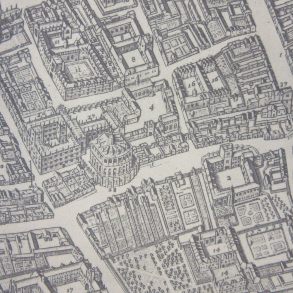
The Great Fire of London started OTD 1666, destroying large parts of the city. Two images, the first from a 1669 survey of the fire by John Leake and others, the second from a beautiful 'Balloon view of London' from 1859, of the monument to mark the fire, completed in 1677 @bodleian.ox.ac.uk

02.09.2025 14:41 β€” πŸ‘ 5    πŸ” 2    πŸ’¬ 0    πŸ“Œ 0
Post image Post image Post image

In-house Ordnance Survey artist Ellis Martin (see a few posts below) often featured his wife Mabel on his map covers, almost always in the pose that can be seen on this map catalogue from 1923 and on the cover of a map of the country round London
@ordnancesurvey.bsky.social @bodleian.ox.ac.uk

01.09.2025 09:44 β€” πŸ‘ 8    πŸ” 3    πŸ’¬ 0    πŸ“Œ 0
Post image Post image

More of a case of no longer seen on a map. The volcanic island of Krakatoa exploded in late August 1883, killing over 36,000 people and sending shock waves around the World. Here are 2 admiralty charts from before and after showing the change in landscape caused by the eruption, @bodleian.ox.ac.uk

28.08.2025 08:44 β€” πŸ‘ 31    πŸ” 7    πŸ’¬ 0    πŸ“Œ 0
Post image Post image Post image Post image

John Thorntons late portolan (1682) of the Indian Ocean is a thing of beauty, gold bling on the compass rose and selected islands, and an early mention for Australia. All held together with very old hinges. See the whole chart here digital.bodleian.ox.ac.uk/objects/5c9b... @bodleian.ox.ac.uk

11.08.2025 08:39 β€” πŸ‘ 2    πŸ” 0    πŸ’¬ 0    πŸ“Œ 0

@stuartackland is following 2 prominent accounts