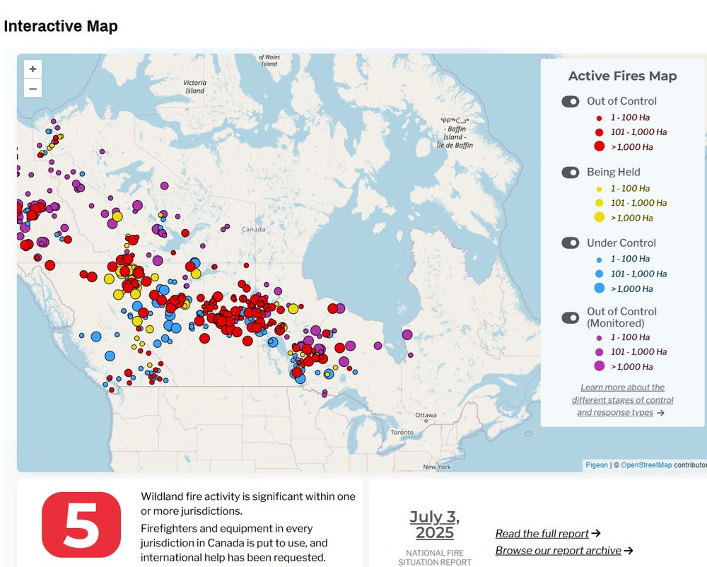
map of canada showing active wildfires link
https://ciffc.ca/
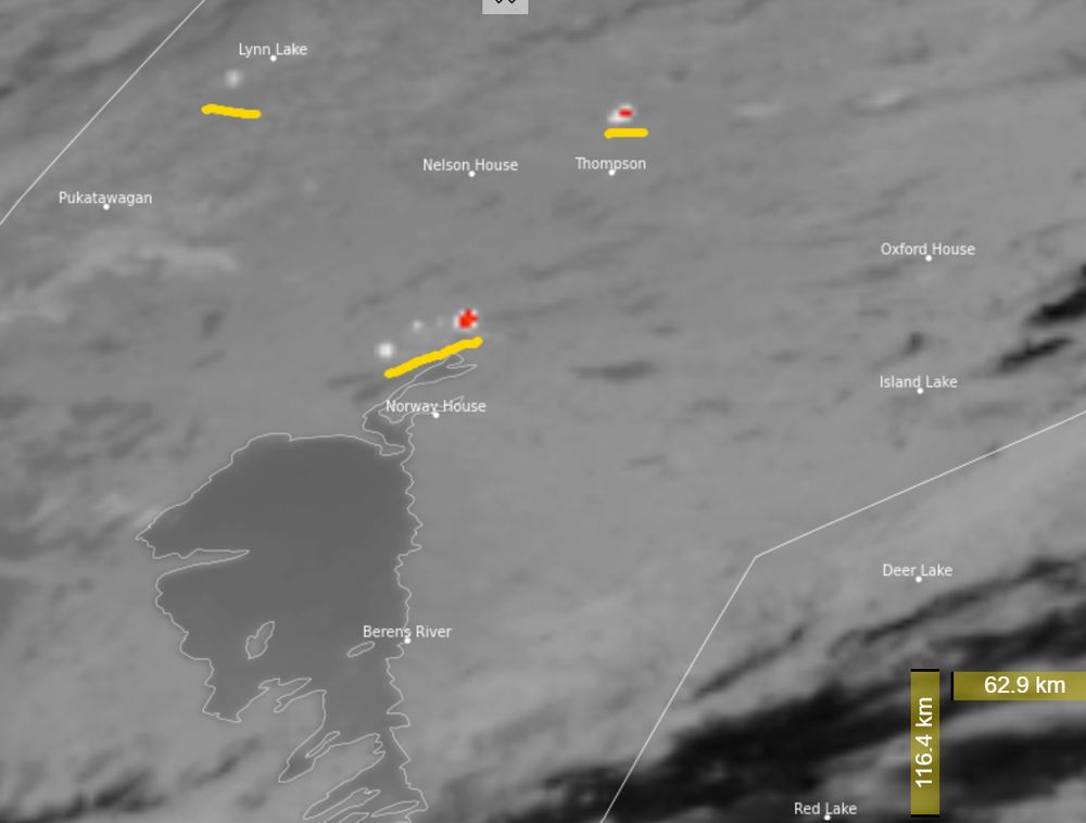
Goes - east mid-ir band ...image - white and red areas are very active fires
https://rammb-slider.cira.colostate.edu/?sat=goes-19&sec=full_disk&x=7939&y=1475&z=5&angle=0&im=12&ts=1&st=0&et=0&speed=130&motion=loop&maps%5Bborders%5D=white&p%5B0%5D=band_06&opacity%5B0%5D=1&pause=0&slider=-1&hide_controls=0&mouse_draw=0&follow_feature=0&follow_hide=0&s=rammb-slider&draw_color=FFD700&draw_width=6
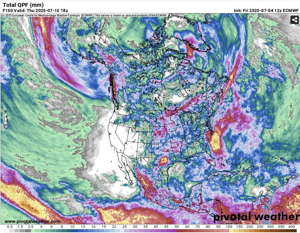
ECMWF quantitative prec. forecasts - white areas are expected to receive no prec. scale on the bottom in mm
https://www.pivotalweather.com/model.php?m=ecmwf_full&p=qpf_acc-met&rh=2025070412&fh=loop&r=na&dpdt=&mc=
Expect lots of fire activity in central Manitoba and NWRN Ontario over the next week. Lots of out-of-control fires in the region (red and purple dots below), some active already today (GOES-East 3.9 micron band - white & red active fires) and the prec. forecast has little to no rain in the region.
04.07.2025 18:23 — 👍 11 🔁 6 💬 0 📌 0


Most recent Sentinel-2 overpass captures the full extent of the western İzmir complex. Originating near Orhanlı on June 29, two separate fires spread more than 13km south in 2 days, driven by northeasterly winds, nearly converging near Ürkmez. Total area burned >10,000 ha.
July 2, 2025 09:04 UTC
02.07.2025 16:55 — 👍 0 🔁 0 💬 0 📌 0

24 saat önce alınan Sentinel-2 görüntüsü, Kavakdere yakınlarında başlayıp Orhanlı, Payamlı ve Doğanbey üzerinden Ürkmez'e ulaşan ve Kuşadası-Seferihisar yolunu geçen geniş bir yanık alanını gösteriyor. Bir sonraki geçişin 23 saat içinde olması bekleniyor.
Saati: 30 Haziran 2025, 11:56 TRT.
01.07.2025 10:02 — 👍 0 🔁 0 💬 0 📌 0
Sentinel-2 imagery captured 24 hours ago shows widespread burning originating near Kavakdere and extending south through Orhanlı, Payamlı, and Doğanbey, reaching Ürkmez town and crossing the Kuşadası-Seferihisar highway. Next Sentinel pass expected in 23 hours.
Captured at 11:56 TRT, 30 June 2025.
01.07.2025 10:02 — 👍 0 🔁 0 💬 1 📌 0

This Meteosat-9 GeoColor satellite image with VIS (0.635 µm) and IR (3.9 µm) band overlays shows fire activity from the Western İzmir Complex and Manisa-Akhisar blaze intensifying into the evening with smoke drifting west over the Aegean.
#Seferihisar #İzmir #Ürkmez #Akhisar
01.07.2025 02:36 — 👍 1 🔁 0 💬 0 📌 0
It sure appears to be…
01.07.2025 00:51 — 👍 0 🔁 0 💬 0 📌 0
Meteosat‑10 Band 1 (0.635 µm) imagery from earlier today shows faint smoke drift from the Western İzmir Province Complex.
The signal is subtle due to resolution limits, but movement is visible off the central west coast of the country.
29.06.2025 20:30 — 👍 0 🔁 0 💬 0 📌 0

FIRMS satellite data confirms concentrated heat detections across the Western İzmir Province Complex across the hills above Seferihisar and between Payamlı and Ürkmez, aligning with ongoing fire activity.
29.06.2025 20:30 — 👍 0 🔁 0 💬 1 📌 0

My parents are currently sheltering on a beach along the coast, waiting this out.
They evacuated earlier today as the Western İzmir Province Complex in Türkiye advanced through the hills between Seferihisar, Payamlı, and Ürkmez.
Roads closed and power out across the region.
29.06.2025 20:30 — 👍 1 🔁 0 💬 1 📌 0

graphs showing fire weather index (FWI), initial spread index (ISI) and vapour pressure deficit (VPD) 95th percentile trends 1979 to 2024. Updated from Jain et al. 2022 https://www.nature.com/articles/s41558-021-01224-1
Updated figure from Jain et al. showing global extreme fire weather trends since 1979. Metrics are global 95th percentile of annual Fire Weather Index (FWI), Initial Spread Index (ISI) and the Vapor Pressure Deficit (VPD). The trend is clear - we are seeing more extreme fire weather due to warming.
26.06.2025 15:14 — 👍 46 🔁 21 💬 2 📌 3

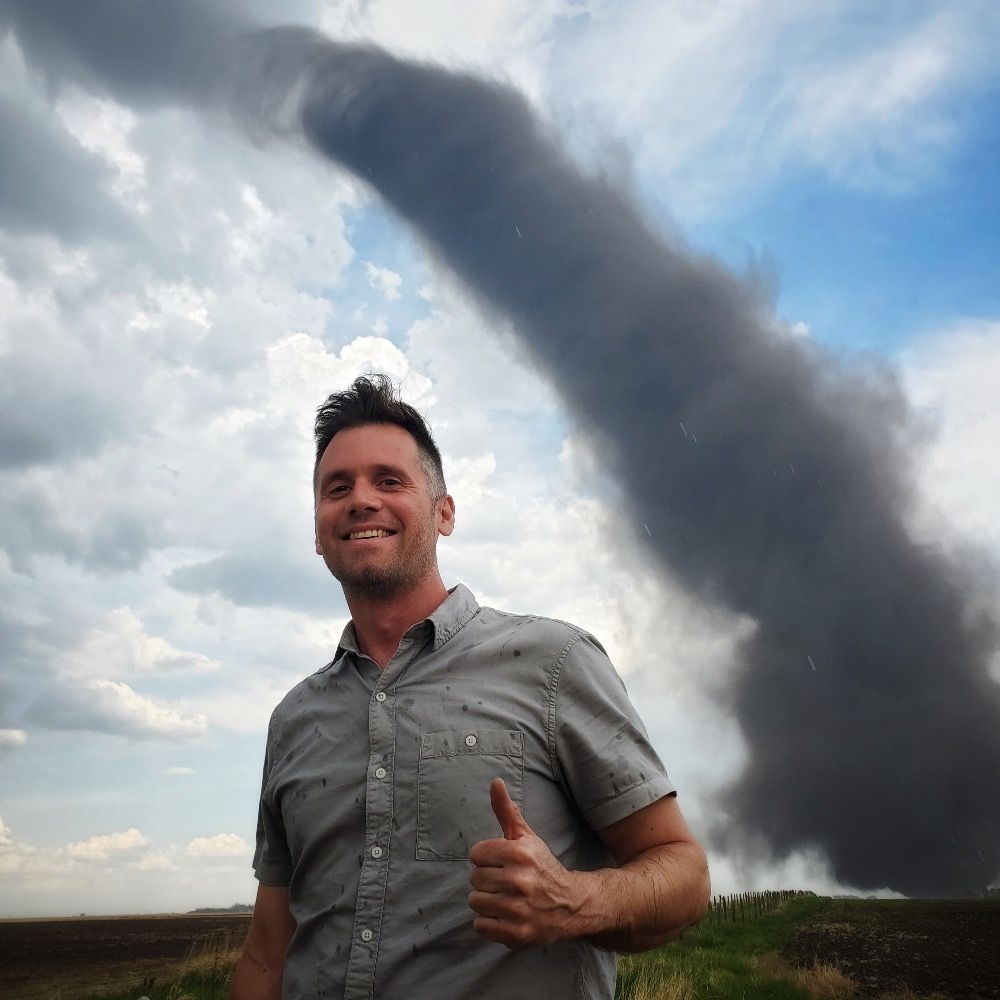
Found in Jasper. Anyone else see what I see?
16.06.2025 17:53 — 👍 0 🔁 0 💬 1 📌 0
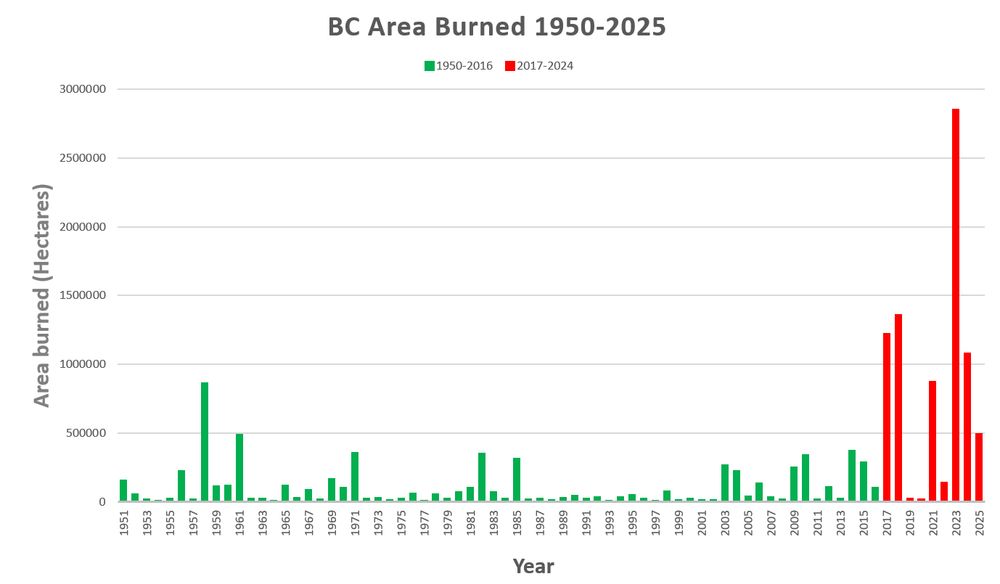
graph showing annual area burned in BC by year for 1950-2025
Area burned for BC is almost 500,000 hectares so far this year. Compared with annual area burned in BC 1950-2024, 2025 is already in 7th place (1950-2025) with much of the fire season ahead of us. The years in red 2017-2025 have more area burned than the years in green (1950-2016).
10.06.2025 22:36 — 👍 41 🔁 19 💬 2 📌 0
Initial Attack with BCWS, and my first summer living in Canada too, it was a shock for sure!
06.06.2025 16:50 — 👍 5 🔁 0 💬 0 📌 0

2025’s off to a hot start. And that 2023 line is wild... and it marks my rookie season as a wildland firefighter, what a year.
06.06.2025 16:17 — 👍 16 🔁 4 💬 1 📌 1
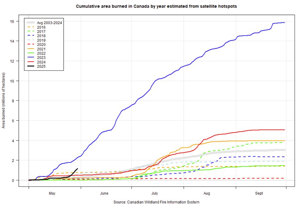
Graph showing area burned in Canada by day of the year
Area burned over 1 million hectares in Canada and increasing. Second only to the 2023 in terms of area burned for this time of year. @ciffc.bsky.social
ciffc.ca
cwfis.cfs.nrcan.gc.ca/maps/fm3?typ...
30.05.2025 20:01 — 👍 115 🔁 79 💬 3 📌 4
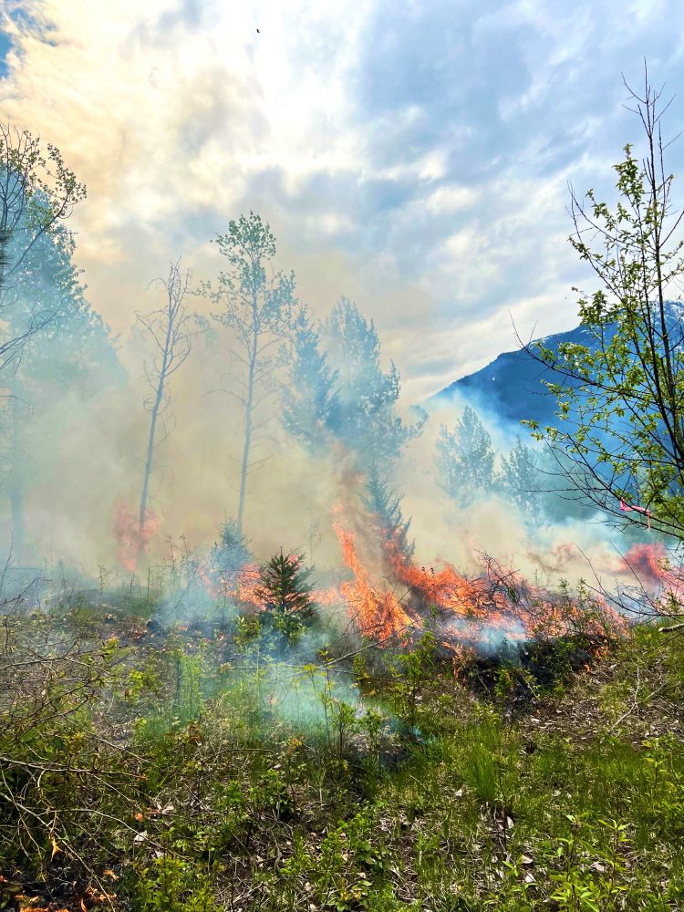
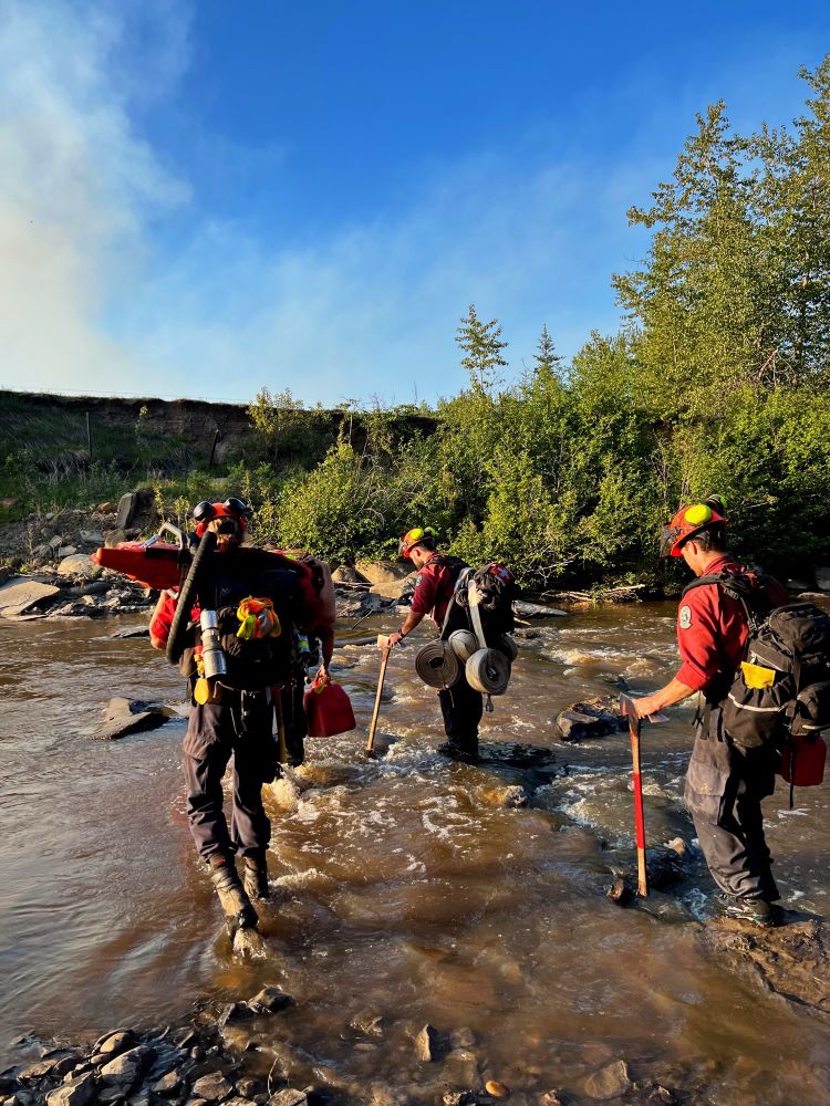
Selection of fires from across the province! Coastal FC IA targets in the first 3 photos, and last one’s from North Peace Complex.
17.04.2025 20:13 — 👍 4 🔁 0 💬 0 📌 0

Very excited to share that I have accepted a @centa.bsky.social funded PhD in wildfire science working with supervisors from the @unibirmingham.bsky.social, @exeter.ac.uk, and @thompsonriversu.bsky.social. After two seasons as an IA firefighter with BCWS, I’m looking forward to this next chapter 🔥
16.04.2025 22:18 — 👍 13 🔁 0 💬 0 📌 0


 01.12.2024 22:14 — 👍 4 🔁 0 💬 0 📌 0
Central England NERC Training Alliance: providing excellence in doctoral research training within the remit of the Natural Environment Research Council.
www.centa.ac.uk
Carbon cycle enthusiast🌊🧪⚒️🖥️ | Professor of Earth Sciences, University of Birmingham | Director CENTA NERC DTP | Immigrant: NYC ➡️ UK | she/her
Professor in Catchment and Wetland Sciences at University of Alberta. Research on impacts of disturbances on function of northern peatlands, with focus on carbon cycling, greenhouse gas emissions, and on downstream water quality.
Prof. of Atmos Sci. @unevadareno. Mountain WX, Wildfire Plumes, Backcountry Skiing, Frontcountry Dadding. Formerly: @SJSUmeteorology @UUtah
@Livermore_Lab @MWObs https://scholar.google.com/citations?user=UGaGnAgAAAAJ&hl=en
Tracking weather and climate and why they matter
climatologylab.org
Extreme Wildfire Events Data Hub for Improved Decision Making | UCPM-2023-KAPP
Web: https://civil-protection-knowledge-network.europa.eu/projects/ewed
Senior Research Scientist with the Canadian Forest Service. 🍁
#Landsat super-fan. #Lidar. #Forests. #Remotesensing. 🌲🛰
Member of the #OrderOfCanada. 🎖
📎https://www.researchgate.net/profile/Michael-Wulder
Associate Professor of Geography at Miami University, Ohio, USA. Remote sensing, fire, landscape ecology, physical geography, natural hazards. Header photo: sunset in Naivasha, Kenya, July 2023 🇰🇪
Postdoc at Hawkesbury Institute for the Environment, WSU 🌳 and Bushfire & Natural Hazards Research Centre 🔥
he/him
@carpentries.carpentries.org instructor
MQ uni & IISER-Pune alum
#PlantEcology #FunctionalTraits #PlantHydraulics #Ecophysiology #Bushfire
fire behaviour | fire ecology | fire management
Associate Professor at University of Trás-os-Montes e Alto Douro,
Managing editor at Inside Climate News. Priors: Center for Public Integrity, Baltimore Sun, Ames (Iowa) Tribune.
Climate PhD researcher, Community Engagement, Waste/Plastic, Radio/TV, Christian, #BanDisposableVapes❌💨Scottish Influencer of the Year 2024/25🏆
Mum of 2, Associate Professor, photographer, traveller, European in UK. Travelling in time and space to uncover past landscapes and 🔥 using fossil pollen |
Director, Center for Climate and Security, DC
Former US Nat'l Intelligence Council
Wisconsinite at heart
Posts my own
Mother | Forester | Professor | Author | Bushwhacker 🌲
Order my book ‘Finding the Mother Tree’
Cariboo Region of British Columbia's mad weatherman in the mountains! YouTube forecaster/chaser, leadership at Wolverine Wildfire Crew.
Host of the Comedeorological Report.
https://www.youtube.com/@JoeyOnly/videos
Tornadoes, wildfires, severe weather.