Announcing deck.gl-raster: 𝐟𝐮𝐥𝐥𝐲 𝐜𝐥𝐢𝐞𝐧𝐭-𝐬𝐢𝐝𝐞 𝐂𝐎𝐆 𝐫𝐞𝐧𝐝𝐞𝐫𝐢𝐧𝐠. No server required.
1.3 𝐠𝐢𝐠𝐚𝐛𝐲𝐭𝐞 COG, streamed directly into the browser: developmentseed.org/deck.gl-rast...
- GPU-accelerated raster reprojection
- GPU image processing for colormaps, nodata values
- Efficient use of COG overviews
07.01.2026 19:11 —
👍 38
🔁 9
💬 5
📌 0
What would happen if the Amazon rainforest collapsed?
Our look at deforestation and feedback loops.
Also, the perfect occasion to make use of our new MapLibre/Protomaps scroller component.
#maps #dataviz #ddj
www.spiegel.de/wissenschaft...
12.11.2025 10:22 —
👍 97
🔁 27
💬 4
📌 3
i think the 2005-2015 era open source boom was built on a nice job environment where people had a little free time and employers believed in creativity
the free time dried up, everyone burned out, 2015-2025 open source has been explicitly targeted toward getting funding & making money. what's next?
14.10.2025 15:27 —
👍 124
🔁 14
💬 15
📌 6
Still time to register for the hybrid workshop on satellite #EO data in agriculture!
Keynote: Prof. Dr. Patrick Hostert from @humboldteolab.bsky.social -Novel Opportunities in Optical Remote Sensing for Agricultural Monitoring Towards 2030.
🛠Hands-on with Sentinel-1, Sentinel-2, PlanetScope & EnMAP
21.08.2025 17:14 —
👍 2
🔁 1
💬 0
📌 0
So often felt like a hidden superpower if used in moderation, READMES etc. Now it's becoming an anti pattern
05.08.2025 22:14 —
👍 1
🔁 0
💬 0
📌 0
Recent tiny blogpost. I mourn Twitter-that-was, and a culture of working in public beyond just the sharing successes and announcements that I see on LinkedIn.
matthewrocklin.com/fail-in-public
(although admittedly this probably is less relevant to the BlueSky crowd)
24.07.2025 12:26 —
👍 3
🔁 2
💬 0
📌 0
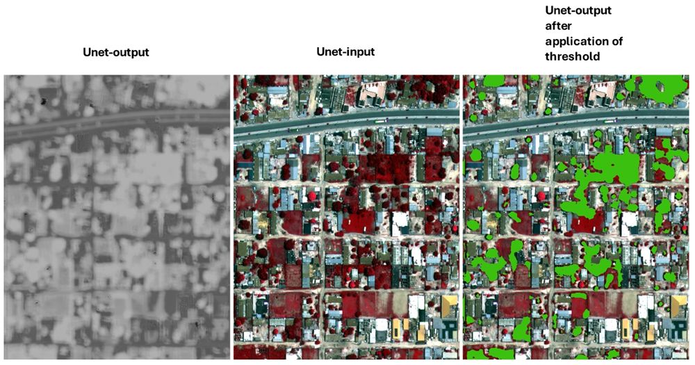
Three-panel image showing a UNet model applied to remote sensing imagery. Left: grayscale UNet output showing probability map of detected features, here trees. Center: input false-color infrared satellite image with vegetation coloured in reddish colours. Right: same input with bright green overlay showing segmented tree crown areas after thresholding.
🚀 Getting started with Deep Learning for remote sensing? Check out these beginner tutorials from FU Berlin: 🧠 UNet in PyTorch: bit.ly/3GBWPx1 🛰️ Segment Anything for GeoTIFFs: bit.ly/3GBWRVF 🌍 #DeepLearning #PyTorch #GeospatialAI #UNet #SegmentAnything #EarthObservation #OpenScience
22.07.2025 08:08 —
👍 9
🔁 2
💬 0
📌 2
Even if you know the COG format pretty well, you will probably find new info in here. Great talk by Jeff Albrecht.
15.07.2025 17:48 —
👍 2
🔁 2
💬 0
📌 0
Anything markdown most likely. mkdocs material, docusaurus are popular for package documentation, for inspiration.
06.07.2025 08:13 —
👍 1
🔁 1
💬 0
📌 0
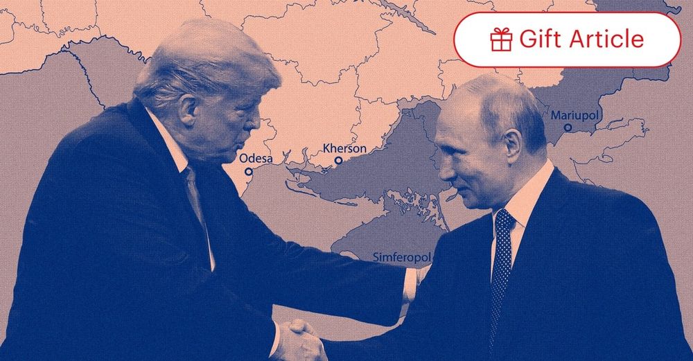
The U.S. Is Switching Sides
Donald Trump is giving Vladimir Putin every incentive to keep killing Ukrainians.
"the American realignment with Russia and against Ukraine and Europe is gathering pace—not merely in rhetoric but in reality"
www.theatlantic.com/ideas/archiv...
04.07.2025 17:40 —
👍 1337
🔁 607
💬 95
📌 74
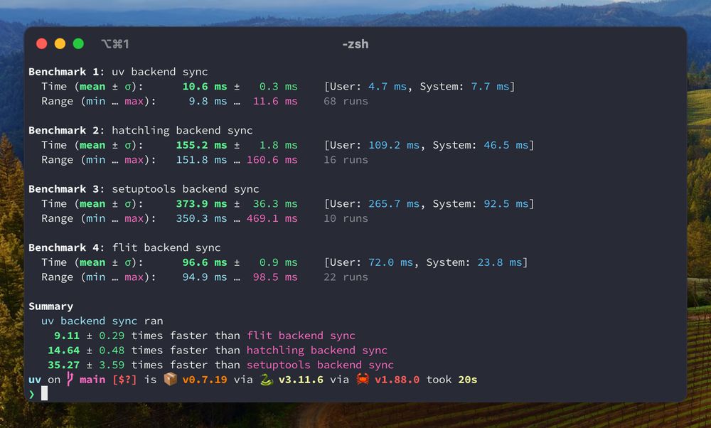
The uv build backend is now stable, and considered ready for production use.
An alternative to setuptools, hatchling, etc. for pure Python projects, with a focus on good defaults, user-friendly error messages, and performance.
When used with uv, it's 10-35x faster.
03.07.2025 01:55 —
👍 236
🔁 43
💬 5
📌 3
ML4Earth one is free though vs AI4EO 500Euro for industry, hmmmm
02.07.2025 15:40 —
👍 0
🔁 0
💬 0
📌 0
Workshop 2025 – ML4
Both seem interesting! ml4earth.de/workshop_2025/ ai4eo2025.irisa.fr
02.07.2025 15:38 —
👍 0
🔁 0
💬 1
📌 0
So now there is the 2day AI4EO symposium in Renne in Sep 25 (previously 3 times in Munich organized by TU Munich), and new 1.5 day ML4Earth in Bonn also in Sep 25, directly organized by TU Munich. What's up with that.
02.07.2025 15:37 —
👍 2
🔁 0
💬 1
📌 0
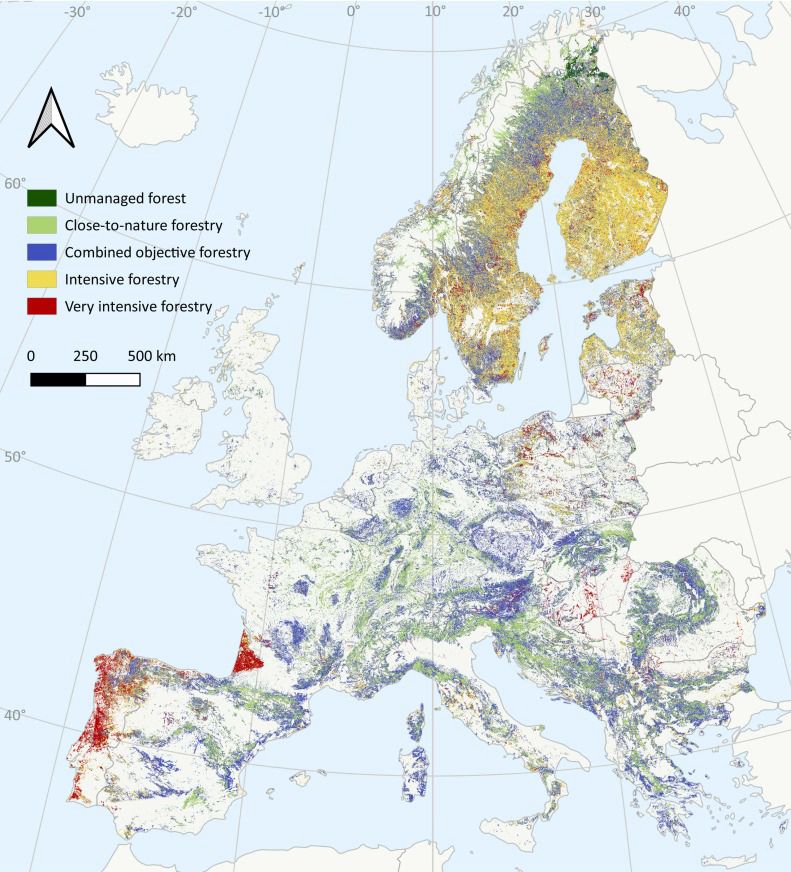
Map of Europe and their forest use. Very little (1%?) is not managed at all
Very cool paper!
It is shocking how few forest areas in Europe are not managed www.sciencedirect.com/science/arti...
01.07.2025 14:26 —
👍 94
🔁 37
💬 1
📌 5
Original post on mapstodon.space
Akis Karagiannis has written an excellent synopsis of the #LivingPlanet Symposium #earthobservation
https://www.spectralreflectance.space/p/reflections-from-the-2025-living
"Several sessions that were supposed to feature NASA researchers ended up half-empty. One session had eight scheduled […]
29.06.2025 19:18 —
👍 2
🔁 2
💬 0
📌 0

Nancy Grave style maps. @johnnelsonmaps.bsky.social
(NANCY GRAVES
Untitled #127 - Drawing of the Moon)
29.06.2025 11:14 —
👍 24
🔁 2
💬 1
📌 0
First time someone from far away knows my hometown just because of it's remote sensing department doing good work with @earth-observation.org & eagle
27.06.2025 14:24 —
👍 2
🔁 0
💬 0
📌 0
🌍 Geospatial Tech Meetup – Explore, Connect, Innovate!, Thu, Jul 10, 2025, 6:30 PM | Meetup
Hey geoawesome folks and map lovers! We’ve got an epic **Geospatial Technology Meetup** coming your way – and you’re invited!
Come hang out with fellow geo-geeks, data wiz
Join us at the Geospatial Tech Meetup in Munich, 10. July! Speakers from OroraTech, Ocell, Huawei. Chill chats after, everyone is welcome and super welcoming! meetu.ps/e/P7p3Q/BHlr...
27.06.2025 14:11 —
👍 3
🔁 1
💬 0
📌 0
🌲🚀 Big leap in #SmartForest AI!
Meet #ForestFormer3D – our new SOTA model for 3D forest segmentation (semantic + instance)! 🌳
🔗 Preprint arxiv.org/abs/2506.16991
🔗 Project bxiang233.github.io/FF3D/
👏 Led by Binbin Xiang + team @NIBIO
#AI #Forestry #SOTA
26.06.2025 09:02 —
👍 10
🔁 3
💬 0
📌 1
Let's do it! Let's pn during event after Monday!
21.06.2025 10:26 —
👍 2
🔁 0
💬 0
📌 0
At Living Planet Symposium next week. Looking forward to lots of ML&forest sessions, but also the random "I have 0 clue about this but it's awesome" volcano, ice etc session. That makes #LPS25 so great. Would love to meet some new people for coffe chat and learn new things! Just ping!
20.06.2025 16:21 —
👍 9
🔁 0
💬 1
📌 0
Cool, let's aim for Tuesday or wedn afternoon coffe break? Will send you PN next week!
20.06.2025 16:07 —
👍 1
🔁 0
💬 0
📌 0
Joined a forest EO company last year, would love to get to know some more people in the community! So much to learn still!
20.06.2025 12:22 —
👍 1
🔁 0
💬 1
📌 0
hah, scrolled back up to the cat picture "was that related". Congratulations :)
19.06.2025 07:46 —
👍 1
🔁 0
💬 1
📌 0
This looks amazing! How did you create that?
17.06.2025 22:43 —
👍 0
🔁 0
💬 1
📌 0
ah yes, you were using gemini-4o-xx1-beta-2, of course you got bad results, you have to use openai-o3-mini-xxl and toggle on the 'do it good' button
27.05.2025 13:53 —
👍 63
🔁 3
💬 3
📌 0
Prof. Dr. Christiane Schmullius
Universitätsprofessorin
My uni professor was the science lead for the German X-band mission part, maybe someone to send an email to www.chemgeo.uni-jena.de/en/29590/sch...
25.05.2025 21:43 —
👍 3
🔁 0
💬 0
📌 0

I'm looking for any info about how & why it was decided to use the Space Shuttle do create SRTM in 2000
A few questions I have:
- How of the world had we mapped in 3D before 2000?
- Why the Space Shuttle over a dedicate satellite (or pair of satellites)
- How the data was processed
25.05.2025 14:15 —
👍 21
🔁 11
💬 8
📌 1