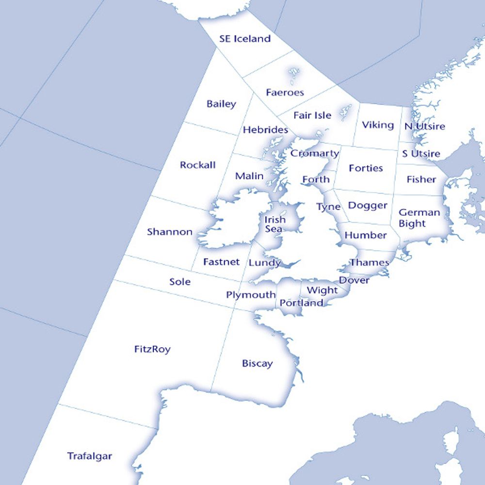
Southeast Iceland
GALE WARNING: Northeasterly severe gale force 9 continuing
(issued at: 21:50 (UTC) on Mon 9 Feb 2026)
09.02.2026 23:45 — 👍 0 🔁 0 💬 0 📌 0
(31/31) Southeast Iceland
Wind: Northeasterly 7 to severe gale 9.
Sea state: Rough or very rough, occasionally high in southwest.
Weather: Squally showers, wintry later.
Visibility: Moderate or poor.
09.02.2026 23:45 — 👍 0 🔁 0 💬 0 📌 0
(30/31) Faeroes
Wind: East or southeast 4 to 6, increasing 6 or 7, perhaps gale 8 later.
Sea state: Moderate or rough, becoming rough or very rough.
Weather: Rain.
Visibility: Moderate or good, occasionally poor.
09.02.2026 23:45 — 👍 0 🔁 0 💬 0 📌 0
(29/31) Fair Isle
Wind: East or southeast 4 to 6, increasing 6 or 7, perhaps gale 8 later.
Sea state: Moderate or rough, becoming rough or very rough except in east.
Weather: Rain.
Visibility: Moderate or good, occasionally poor.
09.02.2026 23:45 — 👍 0 🔁 0 💬 0 📌 0
Bailey
GALE WARNING: Northeasterly gale force 8 expected later
(issued at: 15:54 (UTC) on Mon 9 Feb 2026)
09.02.2026 23:45 — 👍 0 🔁 0 💬 0 📌 0
(28/31) Bailey
Wind: East 4 to 6 backing northeast 6 to gale 8, perhaps severe gale 9 later.
Sea state: Moderate or rough becoming rough or very rough, occasionally high in far northwest.
Weather: Squally showers.
Visibility: Moderate or poor.
09.02.2026 23:45 — 👍 0 🔁 0 💬 0 📌 0
(27/31) Hebrides
Wind: East or southeast 3 to 5, increasing 5 to 7, perhaps gale 8 later.
Sea state: Slight or moderate, becoming moderate or rough, then very rough later in northwest.
Weather: Rain.
Visibility: Moderate or good, occasionally poor.
09.02.2026 23:45 — 👍 0 🔁 0 💬 0 📌 0
(26/31) Malin
Wind: East or southeast 3 to 5, increasing 5 to 7.
Sea state: Slight or moderate, becoming moderate or rough except in southeast.
Weather: Rain.
Visibility: Moderate or good, occasionally poor.
09.02.2026 23:45 — 👍 0 🔁 0 💬 0 📌 0
(25/31) Rockall
Wind: East or southeast, becoming cyclonic, 4 to 6.
Sea state: Rough, occasionally moderate at first in northeast and very rough in southwest.
Weather: Rain.
Visibility: Moderate or good.
09.02.2026 23:45 — 👍 0 🔁 0 💬 0 📌 0
(24/31) Shannon
Wind: Cyclonic 4 to 6, occasionally 7, perhaps gale 8, later.
Sea state: Rough or very rough, becoming high later in southwest.
Weather: Rain.
Visibility: Good, occasionally poor.
09.02.2026 23:45 — 👍 0 🔁 0 💬 0 📌 0
(23/31) Irish Sea
Wind: Southeast, becoming cyclonic later, 4 to 6.
Sea state: Slight or moderate.
Weather: Rain.
Visibility: Good, occasionally poor.
09.02.2026 23:45 — 👍 0 🔁 0 💬 0 📌 0
(22/31) Fastnet
Wind: Cyclonic 3 to 5, becoming west or southwest 4 to 6, occasionally 7.
Sea state: Moderate or rough, becoming very rough in southwest.
Weather: Rain.
Visibility: Good, occasionally poor.
09.02.2026 23:45 — 👍 0 🔁 0 💬 0 📌 0
(21/31) Lundy
Wind: Cyclonic 3 to 5, becoming west or southwest 4 to 6.
Sea state: Moderate or rough, but slight at first in east.
Weather: Rain.
Visibility: Good, occasionally poor.
09.02.2026 23:45 — 👍 0 🔁 0 💬 0 📌 0
Sole
GALE WARNING: Southwesterly gale force 8 expected later
(issued at: 15:54 (UTC) on Mon 9 Feb 2026)
09.02.2026 23:45 — 👍 0 🔁 0 💬 0 📌 0
(20/31) Sole
Wind: Southwest 5 to 7, increasing 7 or gale 8.
Sea state: Rough or very rough becoming very rough or high.
Weather: Thundery rain.
Visibility: Good, occasionally poor.
09.02.2026 23:45 — 👍 0 🔁 0 💬 0 📌 0
FitzRoy
GALE WARNING: Southwesterly gale force 8 expected soon, increasing severe gale force 9 later
(issued at: 21:50 (UTC) on Mon 9 Feb 2026)
09.02.2026 23:45 — 👍 0 🔁 0 💬 0 📌 0
(19/31) FitzRoy
Wind: Southwest 5 to 7, increasing 7 or gale 8, occasionally severe gale 9 later.
Sea state: Rough or very rough becoming very rough or high.
Weather: Thundery rain.
Visibility: Good, occasionally poor.
09.02.2026 23:45 — 👍 0 🔁 0 💬 0 📌 0
(18/31) Trafalgar
Wind: Southwest 4 to 6.
Sea state: Rough or very rough, occasionally moderate in southeast.
Weather: Showers.
Visibility: Good, occasionally moderate.
09.02.2026 23:45 — 👍 0 🔁 0 💬 0 📌 0
Biscay
GALE WARNING: Southwesterly gale force 8 expected later
(issued at: 15:54 (UTC) on Mon 9 Feb 2026)
09.02.2026 23:45 — 👍 0 🔁 0 💬 0 📌 0
(17/31) Biscay
Wind: Southwest 5 to 7, increasing gale 8, perhaps severe gale 9 later.
Sea state: Rough or very rough becoming very rough or high.
Weather: Thundery rain.
Visibility: Good, occasionally poor.
09.02.2026 23:45 — 👍 0 🔁 0 💬 0 📌 0
(16/31) Plymouth
Wind: Southwest 3 to 5, veering west 5 to 7.
Sea state: Moderate or rough, becoming rough or very rough.
Weather: Rain or thundery showers.
Visibility: Good, occasionally poor.
09.02.2026 23:45 — 👍 0 🔁 0 💬 0 📌 0
(15/31) Portland
Wind: Southwest 3 to 5, veering west 5 or 6.
Sea state: Slight at first in southeast, otherwise moderate or rough.
Weather: Rain or showers.
Visibility: Good, occasionally poor.
09.02.2026 23:45 — 👍 0 🔁 0 💬 0 📌 0
(14/31) Wight
Wind: South or southeast, veering southwest, 3 to 5, occasionally 6 at first.
Sea state: Slight or moderate.
Weather: Rain, fog patches later.
Visibility: Moderate or good, occasionally very poor later.
09.02.2026 23:45 — 👍 0 🔁 0 💬 0 📌 0
(13/31) Dover
Wind: South or southeast, veering southwest, 3 to 5, occasionally 6 at first.
Sea state: Slight or moderate, becoming smooth or slight in north.
Weather: Rain, fog patches later.
Visibility: Moderate or good, occasionally very poor later.
09.02.2026 23:45 — 👍 0 🔁 0 💬 0 📌 0
(12/31) Thames
Wind: South or southeast, 3 to 5, occasionally 6 at first.
Sea state: Slight or moderate, becoming smooth or slight.
Weather: Rain, fog patches later.
Visibility: Moderate or good, occasionally very poor later.
09.02.2026 23:45 — 👍 0 🔁 0 💬 0 📌 0
(11/31) Humber
Wind: South or southeast, 3 to 5.
Sea state: Slight or moderate.
Weather: Rain, fog patches later.
Visibility: Moderate or good, occasionally very poor later.
09.02.2026 23:45 — 👍 0 🔁 0 💬 0 📌 0
(10/31) German Bight
Wind: Southeast backing east, 4 to 6.
Sea state: Slight or moderate.
Weather: Rain, fog patches.
Visibility: Moderate to very poor.
09.02.2026 23:45 — 👍 0 🔁 0 💬 0 📌 0
(9/31) Fisher
Wind: Southeast backing east, 4 to 6.
Sea state: Slight or moderate.
Weather: Rain, fog patches.
Visibility: Moderate to very poor.
09.02.2026 23:45 — 👍 0 🔁 0 💬 0 📌 0
(8/31) Dogger
Wind: Southeast backing east, 5 or 6.
Sea state: Moderate.
Weather: Rain.
Visibility: Moderate or good, occasionally poor.
09.02.2026 23:45 — 👍 0 🔁 0 💬 0 📌 0
(7/31) Tyne
Wind: Southeast backing east, 4 to 6.
Sea state: Moderate occasionally rough later.
Weather: Rain.
Visibility: Moderate or good, occasionally poor.
09.02.2026 23:45 — 👍 0 🔁 0 💬 0 📌 0