FSD issues Area Forecast Discussion (AFD) at Aug 13, 6:31 AM CDT
at Wed, 13 Aug 2025 11:31:40 +0000 via IEMbot
Additional Details Here.
13.08.2025 11:48 — 👍 0 🔁 0 💬 0 📌 0
FSD issues Hazardous Weather Outlook (HWO) at Aug 13, 4:51 AM CDT
at Wed, 13 Aug 2025 09:52:15 +0000 via IEMbot
Additional Details Here.
13.08.2025 10:08 — 👍 0 🔁 0 💬 0 📌 0
FSD issues Grassland Fire Danger (RFD) at Aug 13, 4:37 AM CDT ...LOW FIRE DANGER... via IEMbot
Additional Details Here.
13.08.2025 09:48 — 👍 0 🔁 0 💬 0 📌 0
FSD issues Area Forecast Discussion (AFD) at Aug 13, 3:17 AM CDT
at Wed, 13 Aug 2025 08:17:33 +0000 via IEMbot
Additional Details Here.
13.08.2025 08:28 — 👍 0 🔁 0 💬 0 📌 0
The Storm Prediction Center issues Day 3 Marginal Convective Risk at Aug 13, 7:30z for portions of FSD
at Wed, 13 Aug 2025 07:32:32 +0000 via IEMbot
Additional Details Here.
13.08.2025 07:48 — 👍 0 🔁 0 💬 0 📌 0
SIOUX FALLS Aug 12
Climate Report:
High: 82
Low: 59
Precip: 0.0"
Snow: 0.0" Snow Depth: 0"
at Wed, 13 Aug 2025 06:30:27 +0000 via IEMbot
Additional Details Here.
13.08.2025 06:48 — 👍 0 🔁 0 💬 0 📌 0
SIOUX CITY IA Aug 12
Climate Report:
High: 84
Low: 57
Precip: 0.0"
Snow: 0.0" Snow Depth: 0"
at Wed, 13 Aug 2025 06:30:27 +0000 via IEMbot
Additional Details Here.
13.08.2025 06:48 — 👍 0 🔁 0 💬 0 📌 0
The Storm Prediction Center issues Day 2 Marginal Convective Risk at Aug 13, 5:50z for portions of FSD
at Wed, 13 Aug 2025 05:52:42 +0000 via IEMbot
Additional Details Here.
13.08.2025 06:08 — 👍 0 🔁 0 💬 0 📌 0
FSD issues Area Forecast Discussion (AFD) at Aug 12, 10:50 PM CDT
at Wed, 13 Aug 2025 03:53:34 +0000 via IEMbot
Additional Details Here.
13.08.2025 04:08 — 👍 0 🔁 0 💬 0 📌 0
FSD issues Area Forecast Discussion (AFD) at Aug 12, 6:33 PM CDT
at Tue, 12 Aug 2025 23:34:13 +0000 via IEMbot
Additional Details Here.
12.08.2025 23:48 — 👍 0 🔁 0 💬 0 📌 0
FSD issues Hazardous Weather Outlook (HWO) at Aug 12, 6:42 PM CDT
at Tue, 12 Aug 2025 23:42:42 +0000 via IEMbot
Additional Details Here.
12.08.2025 23:48 — 👍 0 🔁 0 💬 0 📌 0
SIOUX CITY IA Aug 12
Climate Report:
High: 84
Low: 57
Precip: 0.0"
Snow: 0.0" Snow Depth: 0"
at Tue, 12 Aug 2025 22:40:51 +0000 via IEMbot
Additional Details Here.
12.08.2025 22:48 — 👍 0 🔁 0 💬 0 📌 0
FSD issues Area Forecast Discussion (AFD) at Aug 12, 2:40 PM CDT
at Tue, 12 Aug 2025 19:40:47 +0000 via IEMbot
Additional Details Here.
12.08.2025 19:48 — 👍 0 🔁 0 💬 0 📌 0
The Storm Prediction Center issues Day 2 Slight Convective Risk at Aug 12, 17:32z for portions of FSD
at Tue, 12 Aug 2025 17:34:22 +0000 via IEMbot
Additional Details Here.
12.08.2025 17:48 — 👍 0 🔁 0 💬 0 📌 0
FSD issues Hazardous Weather Outlook (HWO) at Aug 12, 11:39 AM CDT
at Tue, 12 Aug 2025 16:40:20 +0000 via IEMbot
Additional Details Here.
12.08.2025 16:48 — 👍 0 🔁 0 💬 0 📌 0
FSD issues Area Forecast Discussion (AFD) at Aug 12, 6:23 AM CDT
at Tue, 12 Aug 2025 11:24:12 +0000 via IEMbot
Additional Details Here.
12.08.2025 11:28 — 👍 0 🔁 0 💬 0 📌 0
FSD issues Hazardous Weather Outlook (HWO) at Aug 12, 4:13 AM CDT
at Tue, 12 Aug 2025 09:13:13 +0000 via IEMbot
Additional Details Here.
12.08.2025 09:28 — 👍 0 🔁 0 💬 0 📌 0
FSD issues Grassland Fire Danger (RFD) at Aug 12, 4:19 AM CDT ...LOW FIRE DANGER... via IEMbot
Additional Details Here.
12.08.2025 09:28 — 👍 0 🔁 0 💬 0 📌 0
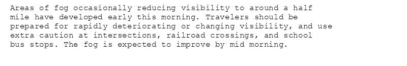
Areas of fog occasionally reducing visibility to around a half
mile have developed early this morning. Travelers should be
prepared for rapidly deteriorating or changing visibility, and use
extra caution at intersections, railroad crossings, and school
bus stops. The fog is expected to improve by mid morning.
Special Weather Statement issued August 12 at 4:01AM CDT by NWS Sioux Falls SD
Additional Details Here.
12.08.2025 09:15 — 👍 0 🔁 0 💬 0 📌 0
FSD issues AREAS OF FOG ACROSS NORTHWEST IOWA, NORTHEAST NEBRASKA, AND FAR SOUTHEAST SOUTH DAKOTA for Buena Vista, Cherokee, Clay, Dickinson, Ida, Lyon, O'Brien, Osceola, Plymouth,... at Tue, 12 Aug 2025 09:01:36 +0000 via IEMbot
Additional Details Here.
12.08.2025 09:08 — 👍 1 🔁 0 💬 0 📌 0
FSD issues Area Forecast Discussion (AFD) at Aug 12, 3:02 AM CDT
at Tue, 12 Aug 2025 08:04:40 +0000 via IEMbot
Additional Details Here.
12.08.2025 08:08 — 👍 0 🔁 0 💬 0 📌 0
SIOUX FALLS Aug 11
Climate Report:
High: 84
Low: 57
Precip: 0.0"
Snow: 0.0" Snow Depth: 0"
at Tue, 12 Aug 2025 06:49:27 +0000 via IEMbot
Additional Details Here.
12.08.2025 07:08 — 👍 0 🔁 0 💬 0 📌 0
HURON Aug 11
Climate Report:
High: 90
Low: 60
Precip: 0.05"
Snow: 0.0" Snow Depth: 0"
at Tue, 12 Aug 2025 06:49:27 +0000 via IEMbot
Additional Details Here.
12.08.2025 07:08 — 👍 0 🔁 0 💬 0 📌 0
The Storm Prediction Center issues Day 2 Marginal Convective Risk at Aug 12, 5:28z for portions of FSD
at Tue, 12 Aug 2025 05:30:15 +0000 via IEMbot
Additional Details Here.
12.08.2025 05:48 — 👍 0 🔁 0 💬 0 📌 0
FSD issues Area Forecast Discussion (AFD) at Aug 11, 10:37 PM CDT
at Tue, 12 Aug 2025 03:37:16 +0000 via IEMbot
Additional Details Here.
12.08.2025 03:48 — 👍 0 🔁 0 💬 0 📌 0
FSD expires Severe Thunderstorm Warning for Brookings, Kingsbury [SD]
at Tue, 12 Aug 2025 02:36:31 +0000 via IEMbot
Additional Details Here.
12.08.2025 02:48 — 👍 0 🔁 0 💬 0 📌 0
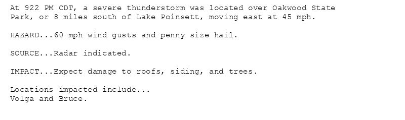
At 922 PM CDT, a severe thunderstorm was located over Oakwood State
Park, or 8 miles south of Lake Poinsett, moving east at 45 mph.
HAZARD...60 mph wind gusts and penny size hail.
SOURCE...Radar indicated.
IMPACT...Expect damage to roofs, siding, and trees.
Locations impacted include...
Volga and Bruce.
🚨 Severe Thunderstorm Warning issued August 11 at 9:22PM CDT until August 11 at 9:45PM CDT by NWS Sioux Falls SD 🚨
Additional Details Here.
12.08.2025 02:30 — 👍 0 🔁 0 💬 0 📌 0
FSD continues Severe Thunderstorm Warning [wind: 60 MPH (RADAR INDICATED), hail: 0.75 IN (RADAR INDICATED)] for Brookings, Kingsbury [SD] till 9:45 PM CDT
at Tue, 12 Aug 2025 02:23:12 +0000 via IEMbot
Additional Details Here.
12.08.2025 02:28 — 👍 0 🔁 0 💬 0 📌 0
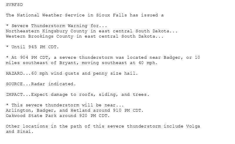
SVRFSD
The National Weather Service in Sioux Falls has issued a
* Severe Thunderstorm Warning for...
Northeastern Kingsbury County in east central South Dakota...
Western Brookings County in east central South Dakota...
* Until 945 PM CDT.
* At 904 PM CDT, a severe thunderstorm was located near Badger, or 10
miles southeast of Bryant, moving southeast at 40 mph.
HAZARD...60 mph wind gusts and penny size hail.
SOURCE...Radar indicated.
IMPACT...Expect damage to roofs, siding, and trees.
* This severe thunderstorm will be near...
Arlington, Badger, and Hetland around 910 PM CDT.
Oakwood State Park around 920 PM CDT.
Other locations in the path of this severe thunderstorm include Volga
and Sinai.
🚨 Severe Thunderstorm Warning issued August 11 at 9:05PM CDT until August 11 at 9:45PM CDT by NWS Sioux Falls SD 🚨
Additional Details Here.
12.08.2025 02:15 — 👍 0 🔁 0 💬 0 📌 0
FSD issues Severe Thunderstorm Warning [wind: 60 MPH (RADAR INDICATED), hail: 0.75 IN (RADAR INDICATED)] for Brookings, Kingsbury [SD] till 9:45 PM CDT
at Tue, 12 Aug 2025 02:05:26 +0000 via IEMbot
Additional Details Here.
12.08.2025 02:08 — 👍 0 🔁 0 💬 0 📌 0