PSR issues Area Forecast Discussion (AFD) at Aug 14, 2:57 AM MST
at Thu, 14 Aug 2025 09:59:02 +0000 via IEMbot
Additional Details Here.
14.08.2025 10:06 — 👍 0 🔁 0 💬 0 📌 0
PHOENIX AZ Aug 13
Climate Report:
High: 109
Low: 90
Precip: Trace
Snow: 0.0" Snow Depth: 0"
at Thu, 14 Aug 2025 08:29:33 +0000 via IEMbot
Additional Details Here.
14.08.2025 08:46 — 👍 0 🔁 0 💬 0 📌 0
PSR expires Flood Advisory for Maricopa [AZ]
at Thu, 14 Aug 2025 07:36:57 +0000 via IEMbot
Additional Details Here.
14.08.2025 07:46 — 👍 0 🔁 0 💬 0 📌 0
PSR issues Area Forecast Discussion (AFD) at Aug 13, 10:58 PM MST
at Thu, 14 Aug 2025 06:00:05 +0000 via IEMbot
Additional Details Here.
14.08.2025 06:06 — 👍 0 🔁 0 💬 0 📌 0
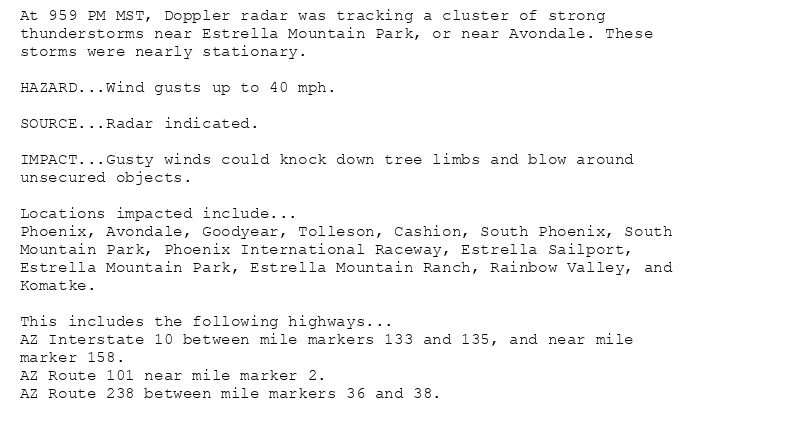
At 959 PM MST, Doppler radar was tracking a cluster of strong
thunderstorms near Estrella Mountain Park, or near Avondale. These
storms were nearly stationary.
HAZARD...Wind gusts up to 40 mph.
SOURCE...Radar indicated.
IMPACT...Gusty winds could knock down tree limbs and blow around
unsecured objects.
Locations impacted include...
Phoenix, Avondale, Goodyear, Tolleson, Cashion, South Phoenix, South
Mountain Park, Phoenix International Raceway, Estrella Sailport,
Estrella Mountain Park, Estrella Mountain Ranch, Rainbow Valley, and
Komatke.
This includes the following highways...
AZ Interstate 10 between mile markers 133 and 135, and near mile
marker 158.
AZ Route 101 near mile marker 2.
AZ Route 238 between mile markers 36 and 38.
Special Weather Statement issued August 13 at 9:59PM MST by NWS Phoenix AZ
Additional Details Here.
14.08.2025 05:15 — 👍 1 🔁 1 💬 0 📌 0
PSR expires Severe Thunderstorm Warning for Maricopa [AZ]
at Thu, 14 Aug 2025 04:55:37 +0000 via IEMbot
Additional Details Here.
14.08.2025 05:07 — 👍 1 🔁 0 💬 0 📌 0
PSR issues Airport Weather Warning (AWW) at Aug 13, 9:29 PM MST ...Airport Weather Warning for Phoenix Sky Harbor Airport until 1030 PM MST for lightning.... via IEMbot
Additional Details Here.
14.08.2025 04:46 — 👍 1 🔁 0 💬 0 📌 0
PSR continues Severe Thunderstorm Warning [wind: 60 MPH (RADAR INDICATED), hail: <.75 IN (RADAR INDICATED)] for Maricopa [AZ] till 10:00 PM MST
at Thu, 14 Aug 2025 04:41:20 +0000 via IEMbot
Additional Details Here.
14.08.2025 04:46 — 👍 1 🔁 0 💬 0 📌 0
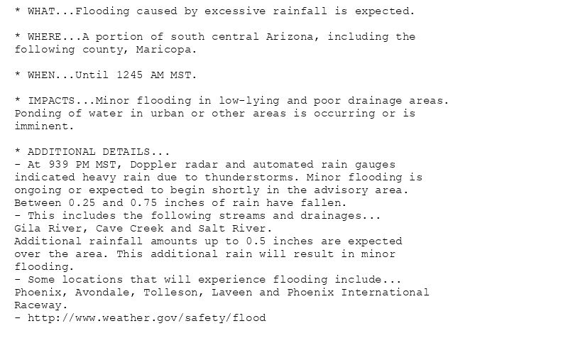
* WHAT...Flooding caused by excessive rainfall is expected.
* WHERE...A portion of south central Arizona, including the
following county, Maricopa.
* WHEN...Until 1245 AM MST.
* IMPACTS...Minor flooding in low-lying and poor drainage areas.
Ponding of water in urban or other areas is occurring or is
imminent.
* ADDITIONAL DETAILS...
- At 939 PM MST, Doppler radar and automated rain gauges
indicated heavy rain due to thunderstorms. Minor flooding is
ongoing or expected to begin shortly in the advisory area.
Between 0.25 and 0.75 inches of rain have fallen.
- This includes the following streams and drainages...
Gila River, Cave Creek and Salt River.
Additional rainfall amounts up to 0.5 inches are expected
over the area. This additional rain will result in minor
flooding.
- Some locations that will experience flooding include...
Phoenix, Avondale, Tolleson, Laveen and Phoenix International
Raceway.
- http://www.weather.gov/safety/flood
Flood Advisory issued August 13 at 9:39PM MST until August 14 at 12:45AM MST by NWS Phoenix AZ
Additional Details Here.
14.08.2025 04:45 — 👍 1 🔁 0 💬 0 📌 0
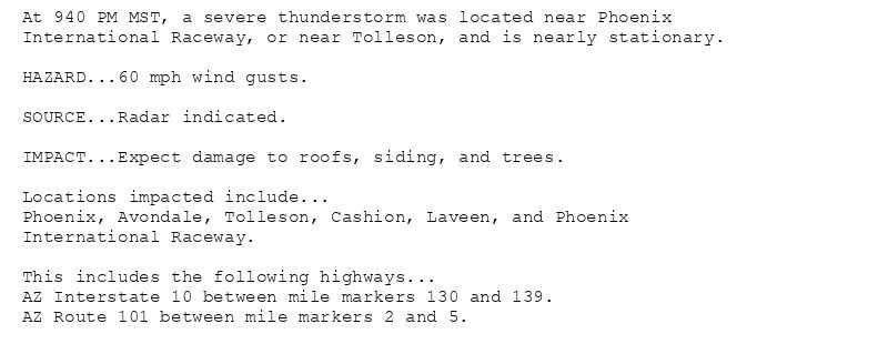
At 940 PM MST, a severe thunderstorm was located near Phoenix
International Raceway, or near Tolleson, and is nearly stationary.
HAZARD...60 mph wind gusts.
SOURCE...Radar indicated.
IMPACT...Expect damage to roofs, siding, and trees.
Locations impacted include...
Phoenix, Avondale, Tolleson, Cashion, Laveen, and Phoenix
International Raceway.
This includes the following highways...
AZ Interstate 10 between mile markers 130 and 139.
AZ Route 101 between mile markers 2 and 5.
🚨 Severe Thunderstorm Warning issued August 13 at 9:40PM MST until August 13 at 10:00PM MST by NWS Phoenix AZ 🚨
Additional Details Here.
14.08.2025 04:45 — 👍 0 🔁 0 💬 0 📌 0
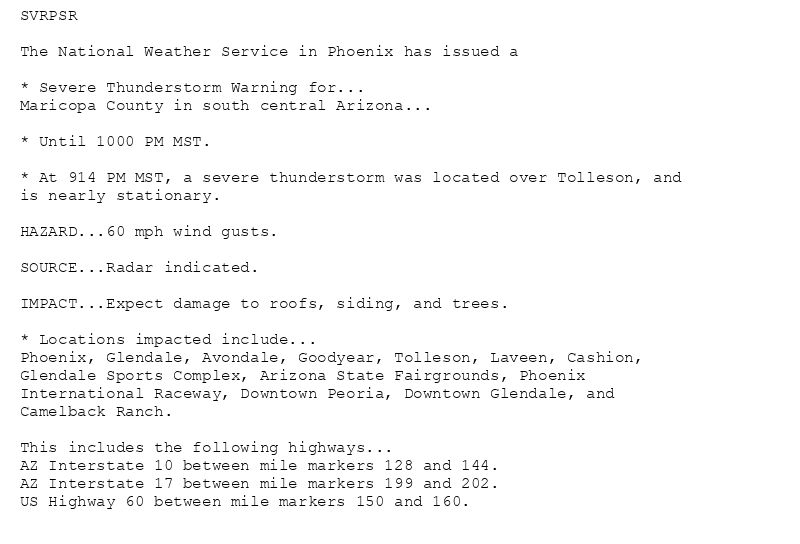
SVRPSR
The National Weather Service in Phoenix has issued a
* Severe Thunderstorm Warning for...
Maricopa County in south central Arizona...
* Until 1000 PM MST.
* At 914 PM MST, a severe thunderstorm was located over Tolleson, and
is nearly stationary.
HAZARD...60 mph wind gusts.
SOURCE...Radar indicated.
IMPACT...Expect damage to roofs, siding, and trees.
* Locations impacted include...
Phoenix, Glendale, Avondale, Goodyear, Tolleson, Laveen, Cashion,
Glendale Sports Complex, Arizona State Fairgrounds, Phoenix
International Raceway, Downtown Peoria, Downtown Glendale, and
Camelback Ranch.
This includes the following highways...
AZ Interstate 10 between mile markers 128 and 144.
AZ Interstate 17 between mile markers 199 and 202.
US Highway 60 between mile markers 150 and 160.
🚨 Severe Thunderstorm Warning issued August 13 at 9:14PM MST until August 13 at 10:00PM MST by NWS Phoenix AZ 🚨
Additional Details Here.
14.08.2025 04:30 — 👍 0 🔁 0 💬 0 📌 0
PSR issues Severe Thunderstorm Warning [wind: 60 MPH (RADAR INDICATED), hail: <.75 IN (RADAR INDICATED)] for Maricopa [AZ] till 10:00 PM MST
at Thu, 14 Aug 2025 04:15:25 +0000 via IEMbot
Additional Details Here.
14.08.2025 04:26 — 👍 0 🔁 0 💬 0 📌 0
At 906 PM MST, Doppler radar was tracking a strong thunderstorm over
Arizona State Fairgrounds, or near Laveen. This thunderstorm was
nearly stationary.
HAZARD...Wind gusts up to 40 mph.
SOURCE...Radar indicated.
IMPACT...Gusty winds could knock down tree limbs and blow around
unsecured objects.
Locations impacted include...
Phoenix, Glendale, Avondale, Paradise Valley, Tolleson, Laveen,
Cashion, Glendale Sports Complex, Piestewa Peak Park, North Mountain
Park, South Phoenix, Arizona State Fairgrounds, South Mountain Park,
Phoenix International Raceway, Downtown Peoria, Downtown Phoenix,
Arrowhead Mall, Downtown Glendale, Metro Center, and Camelback Ranch.
This includes the following highways...
AZ Interstate 10 between mile markers 130 and 152.
AZ Interstate 17 between mile markers 195 and 213.
AZ Route 51 between mile markers 1 and 9.
Special Weather Statement issued August 13 at 9:06PM MST by NWS Phoenix AZ
Additional Details Here.
14.08.2025 04:15 — 👍 0 🔁 0 💬 0 📌 0
PSR expires Blowing Dust Advisory for Northwest Pinal County [AZ]
at Thu, 14 Aug 2025 04:02:08 +0000 via IEMbot
Additional Details Here.
14.08.2025 04:06 — 👍 0 🔁 0 💬 0 📌 0
PSR issues Airport Weather Warning (AWW) at Aug 13, 8:36 PM MST ...Airport Weather Warning for Phoenix Sky Harbor Airport until 930 PM MST for lightning.... via IEMbot
Additional Details Here.
14.08.2025 03:46 — 👍 1 🔁 0 💬 0 📌 0
At 821 PM MST, Doppler radar was tracking a strong thunderstorm near
New River. This thunderstorm was nearly stationary.
HAZARD...Wind gusts up to 40 mph and pea size hail.
SOURCE...Radar indicated.
IMPACT...Gusty winds could knock down tree limbs and blow around
unsecured objects. Minor damage to outdoor objects is
possible.
Locations impacted include...
Phoenix, New River, Cave Creek, Carefree, Deer Valley Airport, Desert
Ridge Marketplace, and Anthem.
This includes the following highways...
AZ Interstate 17 between mile markers 215 and 229.
AZ Route 51 between mile markers 14 and 15.
AZ Route 101 between mile markers 22 and 32.
Special Weather Statement issued August 13 at 8:21PM MST by NWS Phoenix AZ
Additional Details Here.
14.08.2025 03:30 — 👍 0 🔁 0 💬 0 📌 0
PSR issues A STRONG THUNDERSTORM WILL IMPACT MARICOPA COUNTY THROUGH 900 PM MST [wind: 40 MPH, hail: 0.25 IN] for Cave Creek/New River, Deer Valley, New River Mesa, North Phoenix/... at Thu, 14 Aug 2025 03:21:44 +0000 via IEMbot
Additional Details Here.
14.08.2025 03:26 — 👍 1 🔁 0 💬 0 📌 0
* WHAT...Visibility between one-quarter and one mile in blowing
dust. For the Extreme Heat Warning the threat has ended.
* WHERE...Northwest Pinal County.
* WHEN...Until 9 PM MST this evening.
* IMPACTS...Hazardous driving conditions due to reduced visibility.
Blowing Dust Advisory issued August 13 at 8:04PM MST until August 13 at 9:00PM MST by NWS Phoenix AZ
Additional Details Here.
14.08.2025 03:15 — 👍 0 🔁 0 💬 0 📌 0
PSR issues Airport Weather Warning (AWW) at Aug 13, 7:52 PM MST ...Airport Weather Warning for Deer Valley Airport until 900 PM MST for lightning.... via IEMbot
Additional Details Here.
14.08.2025 03:06 — 👍 0 🔁 0 💬 0 📌 0
YUMA AZ Aug 13
Climate Report:
High: 109
Low: 87
Precip: 0.0"
Snow: Missing
at Thu, 14 Aug 2025 00:22:01 +0000 via IEMbot
Additional Details Here.
14.08.2025 00:27 — 👍 1 🔁 0 💬 0 📌 0
PSR issues Area Forecast Discussion (AFD) at Aug 13, 4:52 PM MST
at Wed, 13 Aug 2025 23:52:32 +0000 via IEMbot
Additional Details Here.
14.08.2025 00:06 — 👍 0 🔁 0 💬 0 📌 0
PSR issues GUSTY OUTFLOW WILL IMPACT GILA AND MARICOPA COUNTIES THROUGH 515 PM MST [wind: 40 MPH, hail: 0.00 IN] for Cave Creek/New River, Mazatzal Mountains, New River Mesa, Pina... at Wed, 13 Aug 2025 23:31:18 +0000 via IEMbot
Additional Details Here.
13.08.2025 23:46 — 👍 0 🔁 0 💬 0 📌 0
At 428 PM MST, Doppler radar was tracking a strong outflow boundary
along a line extending from near Mazatzal Peak to near Sycamore
Creek to near Tonto Basin. Movement was south at 25 mph.
HAZARD...Wind gusts up to 40 mph.
SOURCE...Radar indicated.
IMPACT...Gusty winds could knock down tree limbs and blow around
unsecured objects.
Locations impacted include...
Round Valley, Sugarloaf Mountain, Sycamore Creek, Ballantine
Trailhead, Sunflower, Roosevelt, Punkin Center, Roosevelt Dam, Tonto
Basin, Tonto National Monument, Four Peaks, Apache Lake, Rio Verde,
and Oak Spring Canyon.
This includes the following highways...
AZ Route 87 between mile markers 197 and 229.
AZ Route 188 between mile markers 240 and 266.
Special Weather Statement issued August 13 at 4:31PM MST by NWS Phoenix AZ
Additional Details Here.
13.08.2025 23:45 — 👍 0 🔁 0 💬 0 📌 0
PSR issues A STRONG THUNDERSTORM WILL IMPACT GILA COUNTY THROUGH 430 PM MST [wind: 40 MPH, hail: 0.25 IN] for Southeast Gila County [AZ]
at Wed, 13 Aug 2025 22:47:54 +0000 via IEMbot
Additional Details Here.
13.08.2025 23:06 — 👍 0 🔁 0 💬 0 📌 0
At 347 PM MST, Doppler radar was tracking a strong thunderstorm 8
miles south of Bull Butte and on the north side of the Bronco Fire,
or 37 miles northeast of Globe. This thunderstorm was nearly
stationary.
HAZARD...Wind gusts up to 40 mph and pea size hail.
SOURCE...Radar indicated.
IMPACT...Gusty winds could knock down tree limbs and blow around
unsecured objects. Minor damage to outdoor objects is
possible.
Locations impacted include...
Sawmill and Bull Butte.
Special Weather Statement issued August 13 at 3:47PM MST by NWS Phoenix AZ
Additional Details Here.
13.08.2025 23:00 — 👍 0 🔁 0 💬 0 📌 0
PSR continues Blowing Dust Advisory valid at Aug 13, 5:00 PM MST for Northwest Pinal County [AZ] till Aug 13, 9:00 PM MST
at Wed, 13 Aug 2025 20:33:48 +0000 via IEMbot
Additional Details Here.
13.08.2025 20:46 — 👍 0 🔁 0 💬 0 📌 0
* WHAT...Dangerously hot conditions. Afternoon temperatures 107 to
111 degrees. Major Heat Risk.
* WHERE...The Phoenix Metro Area.
* WHEN...Until 8 PM MST this evening.
* IMPACTS...Heat related illnesses increase significantly during
extreme heat events. Overexposure can cause heat cramps and heat
exhaustion to develop and, without intervention, can lead to heat
stroke.
* ADDITIONAL DETAILS...In Maricopa County, call 2-1-1 to find a free
cooling center, transportation, water, and more.
🚨 Extreme Heat Warning issued August 13 at 1:33PM MST until August 13 at 8:00PM MST by NWS Phoenix AZ 🚨
Additional Details Here.(2/2)
13.08.2025 20:45 — 👍 0 🔁 0 💬 0 📌 0
* WHAT...For the Extreme Heat Warning, dangerously hot conditions.
Afternoon temperatures 105 to 111 degrees. Major Heat Risk. For
the Blowing Dust Advisory, visibility between one-quarter and one
mile in blowing dust possible.
* WHERE...Northwest Pinal County.
* WHEN...For the Extreme Heat Warning, until 8 PM MST this evening.
For the Blowing Dust Advisory, from 5 PM this afternoon to 9 PM
MST this evening.
* IMPACTS...Hazardous driving conditions due to reduced visibility.
Heat related illnesses increase significantly during extreme heat
events. Overexposure can cause heat cramps and heat exhaustion to
develop and, without intervention, can lead to heat stroke.
* WHAT...Dangerously hot conditions. Afternoon temperatures 110 to
115 degrees. Major Heat Risk.
* WHERE...Yuma, Salton Sea, Imperial Valley, Palo Verde Valley, and
Chuckwalla Valley.
* WHEN...Until 8 PM MST /8 PM PDT/ this evening.
* IMPACTS...Heat related illnesses increase significantly during
extreme heat events. Overexposure can cause heat cramps and heat
exhaustion to develop and, without intervention, can lead to heat
stroke.
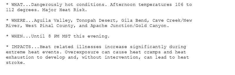
* WHAT...Dangerously hot conditions. Afternoon temperatures 106 to
112 degrees. Major Heat Risk.
* WHERE...Aguila Valley, Tonopah Desert, Gila Bend, Cave Creek/New
River, West Pinal County, and Apache Junction/Gold Canyon.
* WHEN...Until 8 PM MST this evening.
* IMPACTS...Heat related illnesses increase significantly during
extreme heat events. Overexposure can cause heat cramps and heat
exhaustion to develop and, without intervention, can lead to heat
stroke.
🚨 Extreme Heat Warning issued August 13 at 1:33PM MST until August 13 at 8:00PM MST by NWS Phoenix AZ 🚨
Additional Details Here.
(1/2)
13.08.2025 20:45 — 👍 0 🔁 0 💬 0 📌 0
PSR issues Area Forecast Discussion (AFD) at Aug 13, 1:15 PM MST
at Wed, 13 Aug 2025 20:16:52 +0000 via IEMbot
Additional Details Here.
13.08.2025 20:26 — 👍 0 🔁 0 💬 0 📌 0
PSR issues Area Forecast Discussion (AFD) at Aug 13, 10:40 AM MST
at Wed, 13 Aug 2025 17:40:42 +0000 via IEMbot
Additional Details Here.
13.08.2025 17:46 — 👍 0 🔁 0 💬 0 📌 0