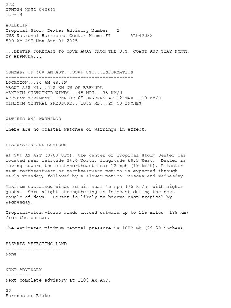
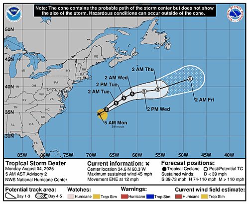
272 WTNT34 KNHC 040841TCPAT4 BULLETINTropical Storm Dexter Advisory Number 2NWS National Hurricane Center Miami FL AL042025500 AM AST Mon Aug 04 2025 ...DEXTER FORECAST TO MOVE AWAY FROM THE U.S. COAST AND STAY NORTH OF BERMUDA... SUMMARY OF 500 AM AST...0900 UTC...INFORMATION----------------------------------------------LOCATION...34.6N 68.3WABOUT 255 MI...415 KM NW OF BERMUDAMAXIMUM SUSTAINED WINDS...45 MPH...75 KM/HPRESENT MOVEMENT...ENE OR 65 DEGREES AT 12 MPH...19 KM/HMINIMUM CENTRAL PRESSURE...1002 MB...29.59 INCHES WATCHES AND WARNINGS--------------------There are no coastal watches or warnings in effect. DISCUSSION AND OUTLOOK----------------------At 500 AM AST (0900 UTC), the center of Tropical Storm Dexter waslocated near latitude 34.6 North, longitude 68.3 West. Dexter ismoving toward the east-northeast near 12 mph (19 km/h). A fastereast-northeastward or northeastward motion is expected throughearly Tuesday, followed by a slower motion Tuesday and Wednesday. Maximum sustained winds remain near 45 mph (75 km/h) with higher gusts. Some slight strengthening is forecast during the next couple of days. Dexter is likely to become post-tropical by Wednesday. Tropical-storm-force winds extend outward up to 115 miles (185 km)from the center. The estimated minimum central pressure is 1002 mb (29.59 inches). HAZARDS AFFECTING LAND----------------------None NEXT ADVISORY-------------Next complete advisory at 1100 AM AST. $$Forecaster Blake
Tropical Storm Dexter 5-Day Uncertainty Track Image
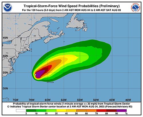
Tropical Storm Dexter 34-Knot Wind Speed Probabilities
Atlantic Tropical Storm Dexter Advisory Number 2 issued at Mon, 04 Aug 2025 08:41:47 +0000
...DEXTER FORECAST TO MOVE AWAY FROM THE U.S. COAST AND STAY NORTH OF BERMUDA...
Additional Details Here.
04.08.2025 08:50 — 👍 2 🔁 0 💬 0 📌 0
ZCZC MIATWOAT ALL<br>TTAA00 KNHC DDHHMM<br><br>Tropical Weather Outlook<br>NWS National Hurricane Center Miami FL<br>200 AM EDT Mon Aug 4 2025<br><br>For the North Atlantic...Caribbean Sea and the Gulf of America:<br><br>Active Systems:<br>The National Hurricane Center is issuing advisories on newly formed <br>Tropical Storm Dexter, located over the western Atlantic Ocean.<br><br>1. Central Tropical Atlantic:<br>A tropical wave is forecast to move off the west coast of Africa <br>later today. Thereafter, some gradual development of the wave is <br>possible, and a tropical depression could form late this week while <br>it moves generally west-northwestward across the central tropical <br>Atlantic.<br>* Formation chance through 48 hours...low...near 0 percent.<br>* Formation chance through 7 days...medium...50 percent.<br><br>2. Off the Southeastern United States:<br>A broad area of low pressure is forecast to form in a couple of <br>days a few hundred miles off the coast of the southeastern United <br>States. Some gradual development of this system is possible during <br>the middle or latter part of the week as the system drifts to the <br>west or northwest. <br>* Formation chance through 48 hours...low...near 0 percent.<br>* Formation chance through 7 days...low...30 percent.<br><br><br><br><br>Public Advisories on Tropical Storm Dexter are issued under WMO <br>header WTNT34 KNHC and under AWIPS header MIATCPAT4.<br>Forecast/Advisories on Tropical Storm Dexter are issued under WMO <br>header WTNT24 KNHC and under AWIPS header MIATCMAT4.<br><br><br>Forecaster Blake<br><br><br>
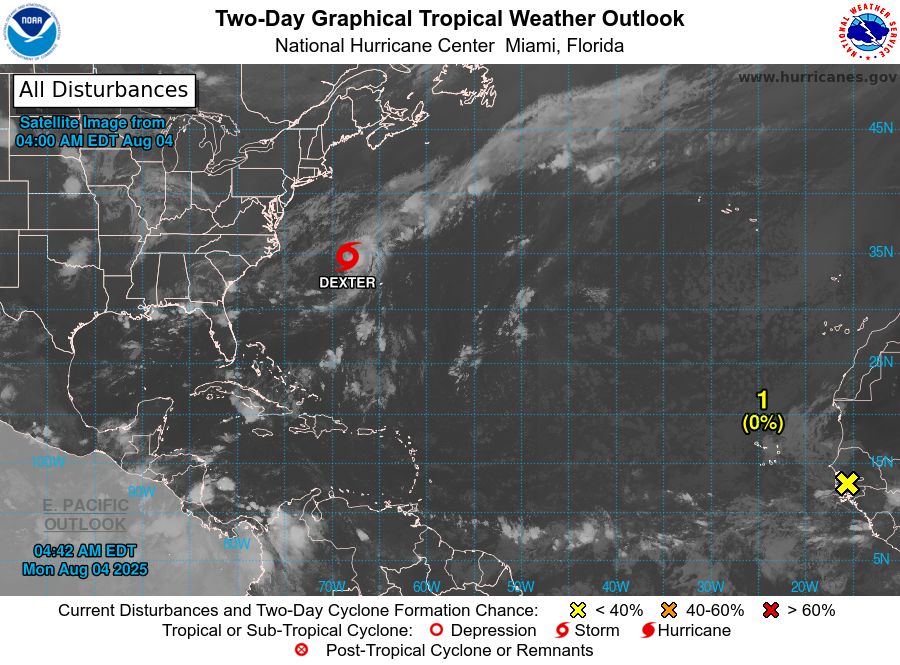
Atlantic 2-Day Graphical Outlook Image
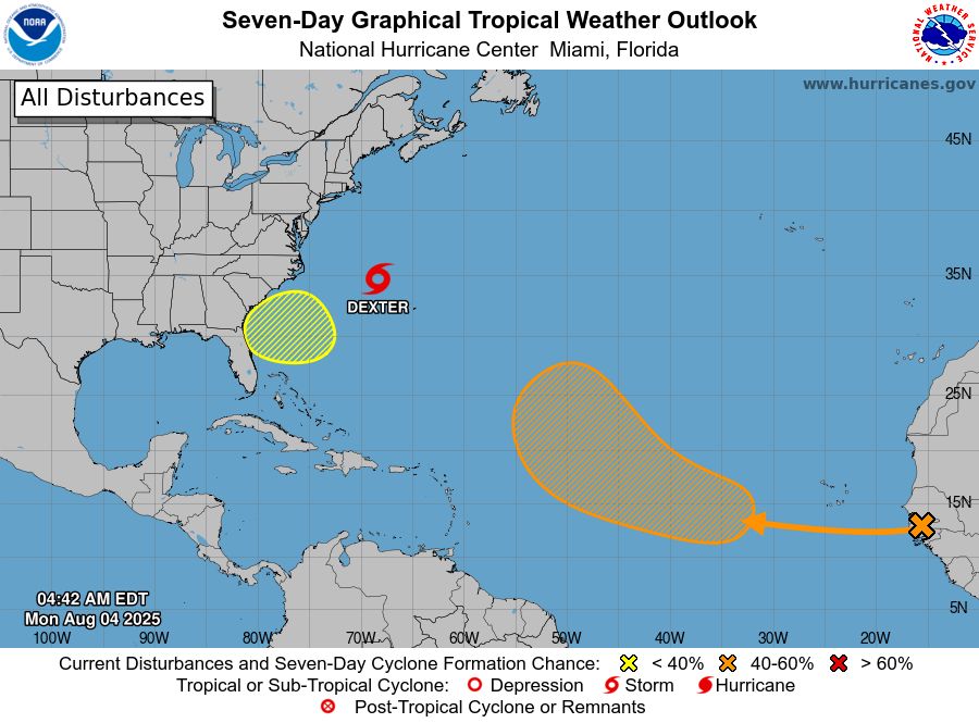
Atlantic 7-Day Graphical Outlook Image
NHC Atlantic Outlook update for Mon, 04 Aug 2025 08:42:17 UTC
Additional Details Here.
04.08.2025 08:50 — 👍 1 🔁 0 💬 0 📌 0
ZCZC MIATWOAT ALL<br>TTAA00 KNHC DDHHMM<br><br>Tropical Weather Outlook<br>NWS National Hurricane Center Miami FL<br>200 AM EDT Mon Aug 4 2025<br><br>For the North Atlantic...Caribbean Sea and the Gulf of America:<br><br>Active Systems:<br>The National Hurricane Center is issuing advisories on newly formed <br>Tropical Storm Dexter, located over the western Atlantic Ocean.<br><br>1. Central Tropical Atlantic:<br>A tropical wave is forecast to move off the west coast of Africa <br>later today. Thereafter, some gradual development of the wave is <br>possible, and a tropical depression could form late this week while <br>it moves generally west-northwestward across the central tropical <br>Atlantic.<br>* Formation chance through 48 hours...low...near 0 percent.<br>* Formation chance through 7 days...medium...50 percent.<br><br>2. Off the Southeastern United States:<br>A broad area of low pressure is forecast to form in a couple of <br>days a few hundred miles off the coast of the southeastern United <br>States. Some gradual development of this system is possible during <br>the middle or latter part of the week as the system drifts to the <br>west or northwest. <br>* Formation chance through 48 hours...low...near 0 percent.<br>* Formation chance through 7 days...low...30 percent.<br><br><br><br><br>Public Advisories on Tropical Storm Dexter are issued under WMO <br>header WTNT34 KNHC and under AWIPS header MIATCPAT4.<br>Forecast/Advisories on Tropical Storm Dexter are issued under WMO <br>header WTNT24 KNHC and under AWIPS header MIATCMAT4.<br><br><br>Forecaster Blake<br><br><br>
Atlantic 2-Day Graphical Outlook Image

Atlantic 7-Day Graphical Outlook Image
NHC Atlantic Outlook update for Mon, 04 Aug 2025 05:33:32 UTC
Additional Details Here.
04.08.2025 05:40 — 👍 2 🔁 0 💬 0 📌 0
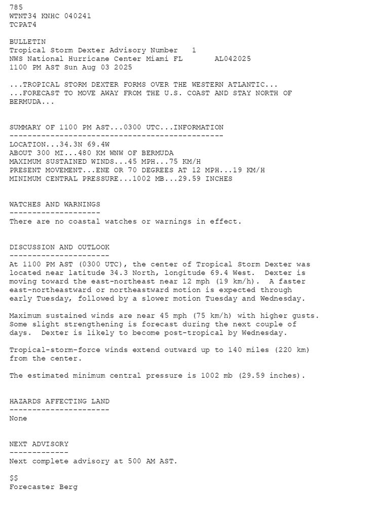
785 WTNT34 KNHC 040241TCPAT4 BULLETINTropical Storm Dexter Advisory Number 1NWS National Hurricane Center Miami FL AL0420251100 PM AST Sun Aug 03 2025 ...TROPICAL STORM DEXTER FORMS OVER THE WESTERN ATLANTIC......FORECAST TO MOVE AWAY FROM THE U.S. COAST AND STAY NORTH OFBERMUDA... SUMMARY OF 1100 PM AST...0300 UTC...INFORMATION-----------------------------------------------LOCATION...34.3N 69.4WABOUT 300 MI...480 KM WNW OF BERMUDAMAXIMUM SUSTAINED WINDS...45 MPH...75 KM/HPRESENT MOVEMENT...ENE OR 70 DEGREES AT 12 MPH...19 KM/HMINIMUM CENTRAL PRESSURE...1002 MB...29.59 INCHES WATCHES AND WARNINGS--------------------There are no coastal watches or warnings in effect. DISCUSSION AND OUTLOOK----------------------At 1100 PM AST (0300 UTC), the center of Tropical Storm Dexter waslocated near latitude 34.3 North, longitude 69.4 West. Dexter ismoving toward the east-northeast near 12 mph (19 km/h). A faster east-northeastward or northeastward motion is expected through early Tuesday, followed by a slower motion Tuesday and Wednesday. Maximum sustained winds are near 45 mph (75 km/h) with higher gusts.Some slight strengthening is forecast during the next couple of days. Dexter is likely to become post-tropical by Wednesday. Tropical-storm-force winds extend outward up to 140 miles (220 km)from the center. The estimated minimum central pressure is 1002 mb (29.59 inches). HAZARDS AFFECTING LAND----------------------None NEXT ADVISORY-------------Next complete advisory at 500 AM AST. $$Forecaster Berg
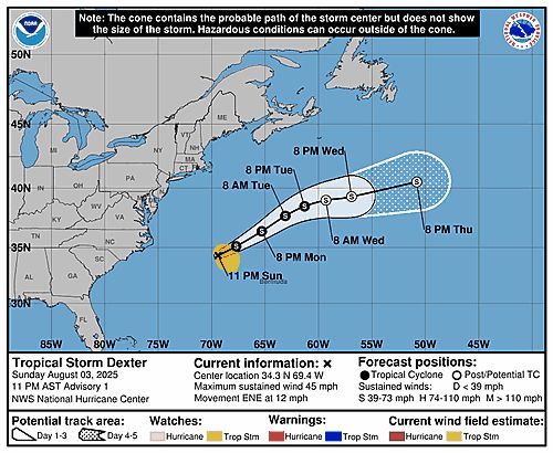
Tropical Storm Dexter 5-Day Uncertainty Track Image
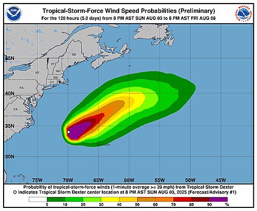
Tropical Storm Dexter 34-Knot Wind Speed Probabilities
Atlantic Tropical Storm Dexter Advisory Number 1 issued at Mon, 04 Aug 2025 02:41:58 +0000
...TROPICAL STORM DEXTER FORMS OVER THE WESTERN ATLANTIC... ...FORECAST TO MOVE AWAY FROM THE U.S. COAST AND STAY NORTH OF BERMUDA...
Additional Details Here.
04.08.2025 02:50 — 👍 14 🔁 8 💬 0 📌 2
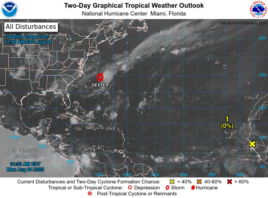
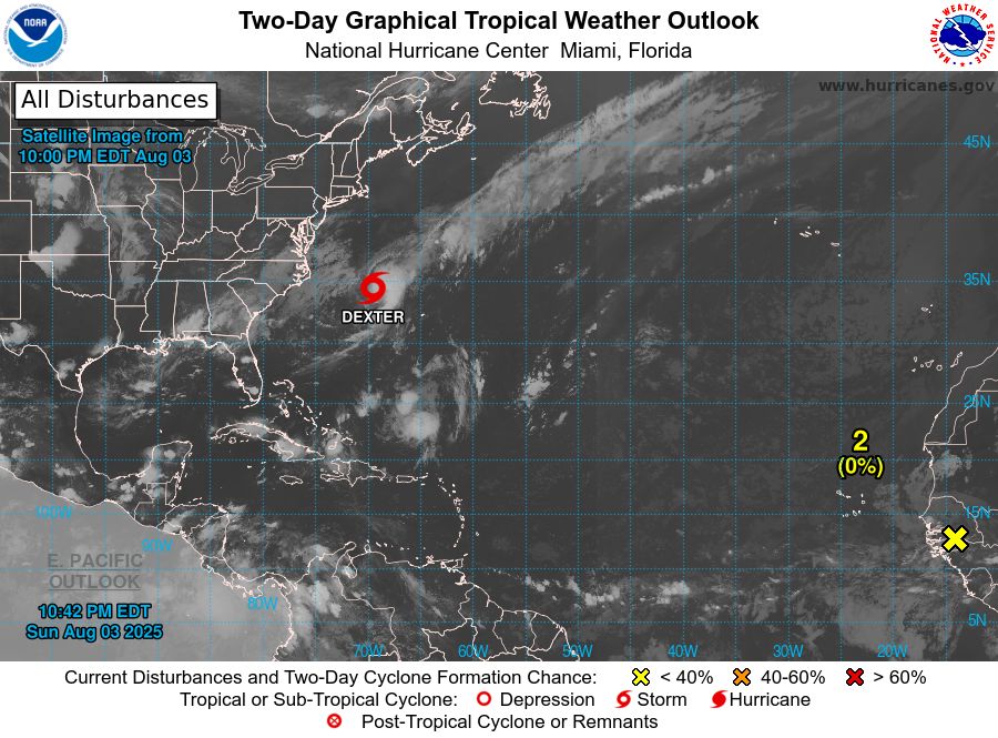
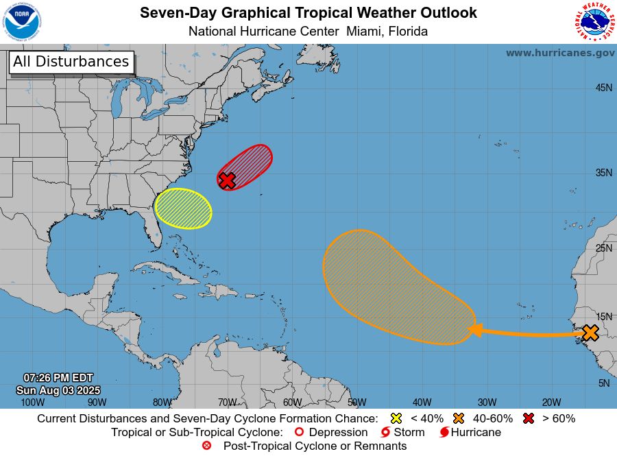
ZCZC MIATWOAT ALL<br>TTAA00 KNHC DDHHMM<br><br>Tropical Weather Outlook<br>NWS National Hurricane Center Miami FL<br>800 PM EDT Sun Aug 3 2025<br><br>For the North Atlantic...Caribbean Sea and the Gulf of America:<br><br>1. Western Atlantic (AL95):<br>Showers and thunderstorms continue to show signs of organization in <br>association with a low pressure system located a few hundred miles <br>east of the North Carolina coast. The low is producing gale-force <br>winds, and it appears that the system is becoming separated from <br>the nearby frontal zone to its north and west. If the shower <br>and thunderstorm activity persists, the low would continue to <br>acquire tropical characteristics, with a tropical storm likely to <br>form later tonight or on Monday while moving east-northeastward at <br>10 to 15 mph over the western Atlantic, away from the coast of North <br>Carolina. For additional information, including gale warnings, <br>please see High Seas Forecasts issued by the National Weather <br>Service.<br>* Formation chance through 48 hours...high...80 percent.<br>* Formation chance through 7 days...high...80 percent.<br><br>2. Central Tropical Atlantic:<br>A tropical wave is forecast to move off the west coast of Africa on <br>Monday. Thereafter, some gradual development of the wave is <br>possible, and a tropical depression could form late this week while <br>it moves generally west-northwestward across the central tropical <br>Atlantic.<br>* Formation chance through 48 hours...low...near 0 percent.<br>* Formation chance through 7 days...medium...40 percent.<br><br>3. Off the Southeastern United States:<br>An area of low pressure could form in a couple of days a few hundred <br>miles off the coast of the southeastern United States. Some <br>gradual development of this system is possible during the middle or <br>latter part of the week as the system drifts to the west or <br>northwest. <br>* Formation chance through 48 hours...low...near 0 percent.<br>* Formation chance through 7 days...low...20 percent.<br><br><br><br><br>High Seas Forecasts issued by the National Weather Service can be <br>found under AWIPS header NFDHSFAT1, WMO header FZNT01 KWBC, and <br>online at ocean.weather.gov/shtml/NFDHSFAT1.php<br><br><br>Forecaster Berg<br><br><br>
Atlantic 2-Day Graphical Outlook Image
Atlantic 7-Day Graphical Outlook Image
NHC Atlantic Outlook update for Mon, 04 Aug 2025 02:42:22 UTC
Additional Details Here.
04.08.2025 02:50 — 👍 7 🔁 3 💬 0 📌 0
ZCZC MIATWOAT ALL<br>TTAA00 KNHC DDHHMM<br><br>Tropical Weather Outlook<br>NWS National Hurricane Center Miami FL<br>800 PM EDT Sun Aug 3 2025<br><br>For the North Atlantic...Caribbean Sea and the Gulf of America:<br><br>1. Western Atlantic (AL95):<br>Showers and thunderstorms continue to show signs of organization in <br>association with a low pressure system located a few hundred miles <br>east of the North Carolina coast. The low is producing gale-force <br>winds, and it appears that the system is becoming separated from <br>the nearby frontal zone to its north and west. If the shower <br>and thunderstorm activity persists, the low would continue to <br>acquire tropical characteristics, with a tropical storm likely to <br>form later tonight or on Monday while moving east-northeastward at <br>10 to 15 mph over the western Atlantic, away from the coast of North <br>Carolina. For additional information, including gale warnings, <br>please see High Seas Forecasts issued by the National Weather <br>Service.<br>* Formation chance through 48 hours...high...80 percent.<br>* Formation chance through 7 days...high...80 percent.<br><br>2. Central Tropical Atlantic:<br>A tropical wave is forecast to move off the west coast of Africa on <br>Monday. Thereafter, some gradual development of the wave is <br>possible, and a tropical depression could form late this week while <br>it moves generally west-northwestward across the central tropical <br>Atlantic.<br>* Formation chance through 48 hours...low...near 0 percent.<br>* Formation chance through 7 days...medium...40 percent.<br><br>3. Off the Southeastern United States:<br>An area of low pressure could form in a couple of days a few hundred <br>miles off the coast of the southeastern United States. Some <br>gradual development of this system is possible during the middle or <br>latter part of the week as the system drifts to the west or <br>northwest. <br>* Formation chance through 48 hours...low...near 0 percent.<br>* Formation chance through 7 days...low...20 percent.<br><br><br><br><br>High Seas Forecasts issued by the National Weather Service can be <br>found under AWIPS header NFDHSFAT1, WMO header FZNT01 KWBC, and <br>online at ocean.weather.gov/shtml/NFDHSFAT1.php<br><br><br>Forecaster Berg<br><br><br>
Atlantic 2-Day Graphical Outlook Image
Atlantic 7-Day Graphical Outlook Image
NHC Atlantic Outlook update for Sun, 03 Aug 2025 23:27:14 UTC
Additional Details Here.
03.08.2025 23:30 — 👍 15 🔁 4 💬 1 📌 3
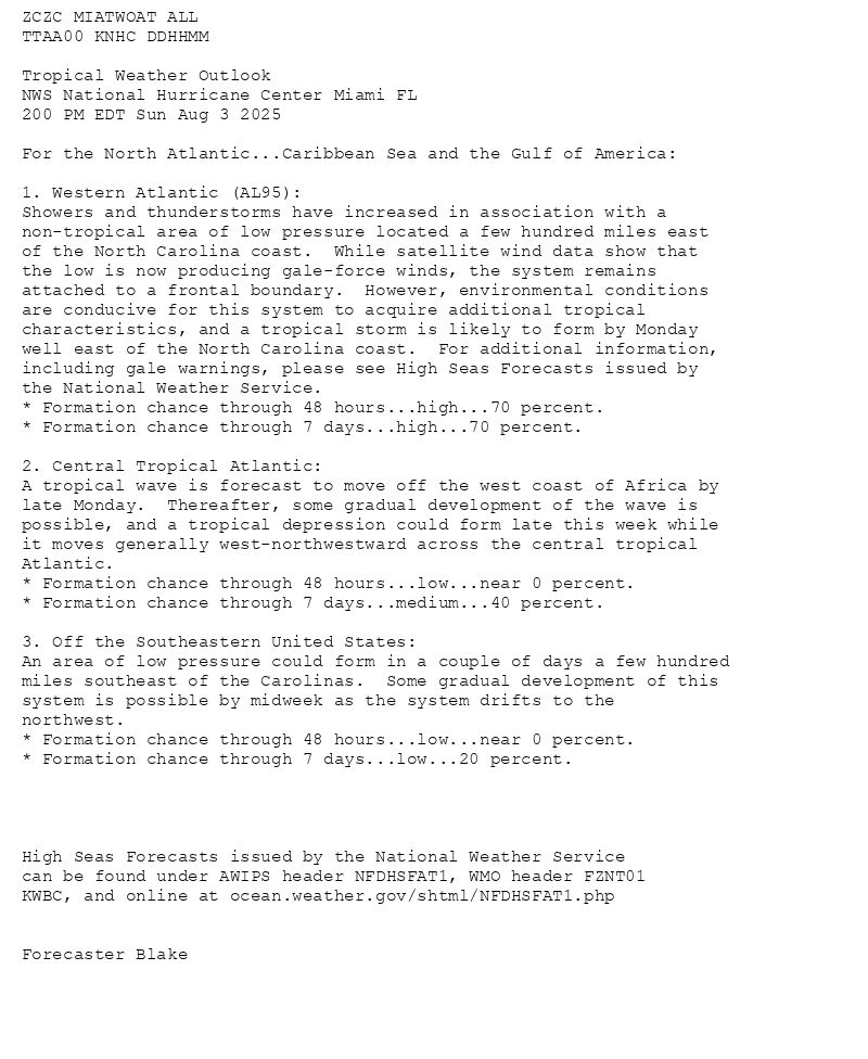
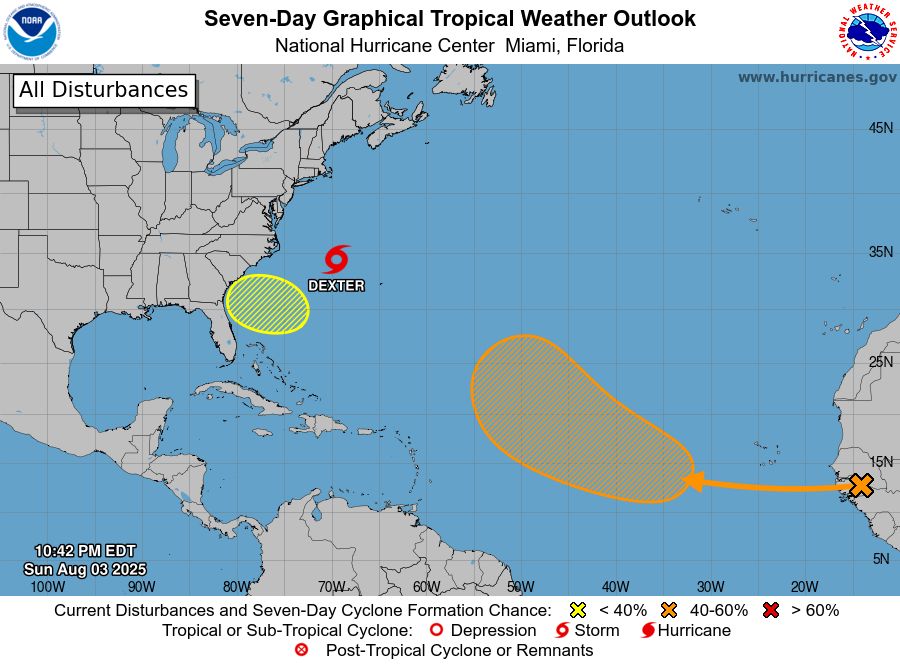
ZCZC MIATWOAT ALL<br>TTAA00 KNHC DDHHMM<br><br>Tropical Weather Outlook<br>NWS National Hurricane Center Miami FL<br>200 PM EDT Sun Aug 3 2025<br><br>For the North Atlantic...Caribbean Sea and the Gulf of America:<br><br>1. Western Atlantic (AL95):<br>Showers and thunderstorms have increased in association with a <br>non-tropical area of low pressure located a few hundred miles east <br>of the North Carolina coast. While satellite wind data show that <br>the low is now producing gale-force winds, the system remains <br>attached to a frontal boundary. However, environmental conditions <br>are conducive for this system to acquire additional tropical <br>characteristics, and a tropical storm is likely to form by Monday <br>well east of the North Carolina coast. For additional information, <br>including gale warnings, please see High Seas Forecasts issued by <br>the National Weather Service.<br>* Formation chance through 48 hours...high...70 percent.<br>* Formation chance through 7 days...high...70 percent.<br><br>2. Central Tropical Atlantic:<br>A tropical wave is forecast to move off the west coast of Africa by <br>late Monday. Thereafter, some gradual development of the wave is <br>possible, and a tropical depression could form late this week while <br>it moves generally west-northwestward across the central tropical <br>Atlantic.<br>* Formation chance through 48 hours...low...near 0 percent.<br>* Formation chance through 7 days...medium...40 percent.<br><br>3. Off the Southeastern United States:<br>An area of low pressure could form in a couple of days a few hundred <br>miles southeast of the Carolinas. Some gradual development of this <br>system is possible by midweek as the system drifts to the <br>northwest. <br>* Formation chance through 48 hours...low...near 0 percent.<br>* Formation chance through 7 days...low...20 percent.<br><br><br><br><br>High Seas Forecasts issued by the National Weather Service<br>can be found under AWIPS header NFDHSFAT1, WMO header FZNT01 <br>KWBC, and online at ocean.weather.gov/shtml/NFDHSFAT1.php<br><br><br>Forecaster Blake<br><br><br>
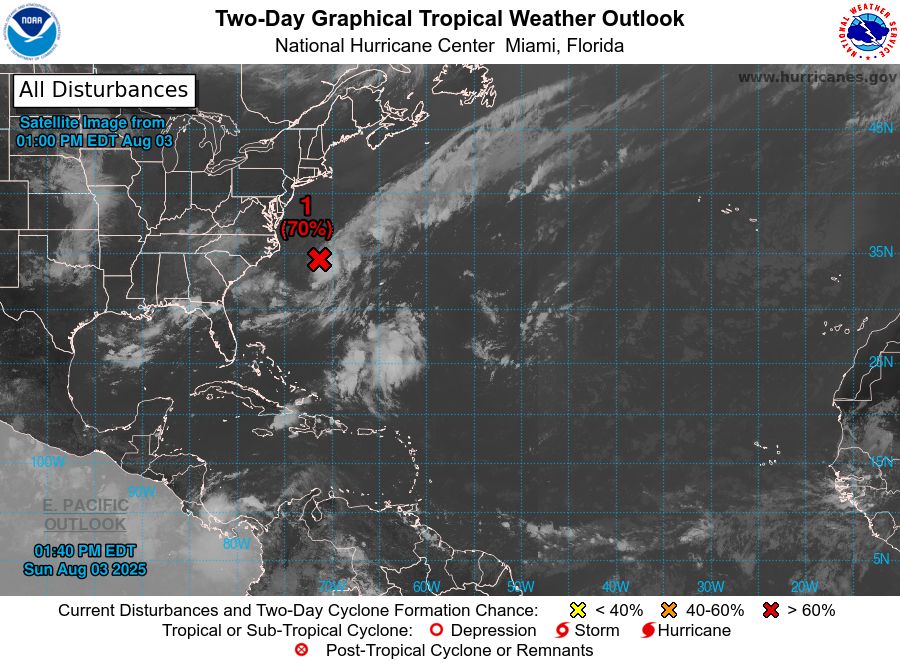
Atlantic 2-Day Graphical Outlook Image
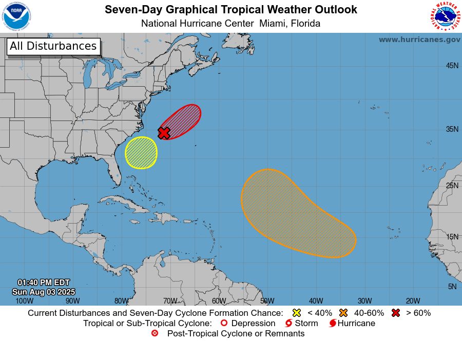
Atlantic 7-Day Graphical Outlook Image
NHC Atlantic Outlook update for Sun, 03 Aug 2025 17:40:34 UTC
Additional Details Here.
03.08.2025 17:50 — 👍 14 🔁 7 💬 0 📌 3
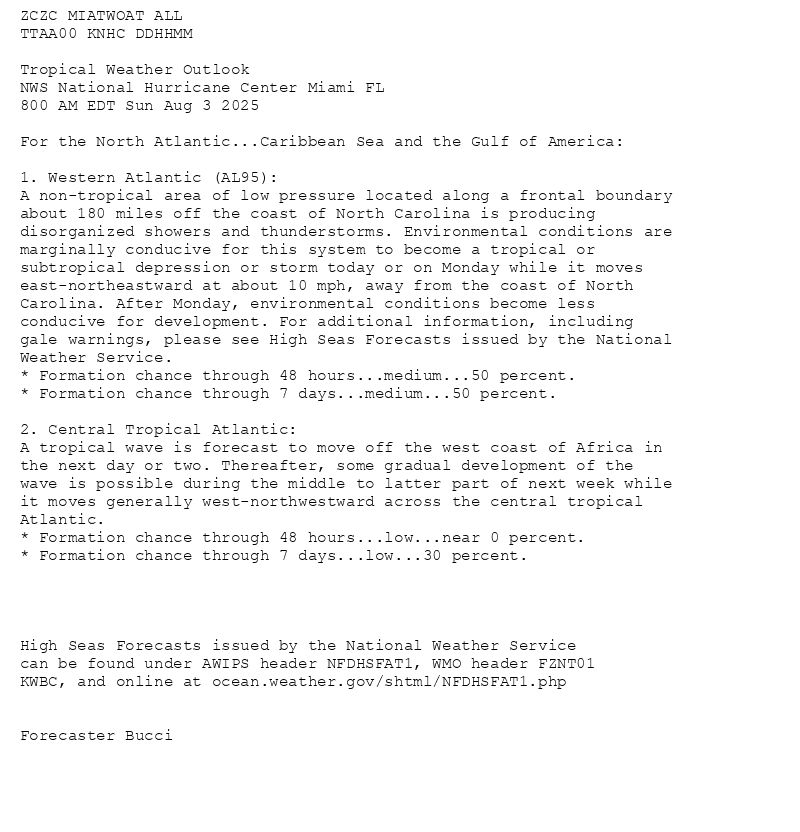
ZCZC MIATWOAT ALL<br>TTAA00 KNHC DDHHMM<br><br>Tropical Weather Outlook<br>NWS National Hurricane Center Miami FL<br>800 AM EDT Sun Aug 3 2025<br><br>For the North Atlantic...Caribbean Sea and the Gulf of America:<br><br>1. Western Atlantic (AL95):<br>A non-tropical area of low pressure located along a frontal boundary <br>about 180 miles off the coast of North Carolina is producing <br>disorganized showers and thunderstorms. Environmental conditions are <br>marginally conducive for this system to become a tropical or <br>subtropical depression or storm today or on Monday while it moves <br>east-northeastward at about 10 mph, away from the coast of North <br>Carolina. After Monday, environmental conditions become less <br>conducive for development. For additional information, including <br>gale warnings, please see High Seas Forecasts issued by the National <br>Weather Service.<br>* Formation chance through 48 hours...medium...50 percent.<br>* Formation chance through 7 days...medium...50 percent.<br><br>2. Central Tropical Atlantic:<br>A tropical wave is forecast to move off the west coast of Africa in <br>the next day or two. Thereafter, some gradual development of the <br>wave is possible during the middle to latter part of next week while <br>it moves generally west-northwestward across the central tropical <br>Atlantic.<br>* Formation chance through 48 hours...low...near 0 percent.<br>* Formation chance through 7 days...low...30 percent.<br><br><br><br><br>High Seas Forecasts issued by the National Weather Service<br>can be found under AWIPS header NFDHSFAT1, WMO header FZNT01 <br>KWBC, and online at ocean.weather.gov/shtml/NFDHSFAT1.php<br><br><br>Forecaster Bucci<br><br><br>
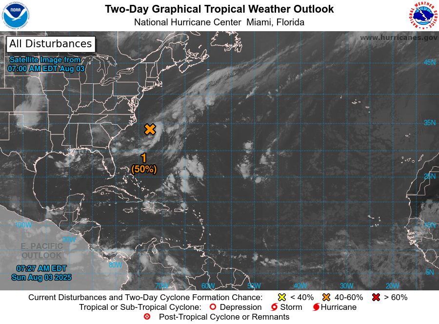
Atlantic 2-Day Graphical Outlook Image
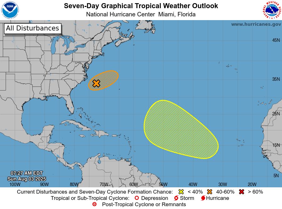
Atlantic 7-Day Graphical Outlook Image
NHC Atlantic Outlook update for Sun, 03 Aug 2025 11:28:00 UTC
Additional Details Here.
03.08.2025 11:30 — 👍 19 🔁 7 💬 1 📌 0
ZCZC MIATWOAT ALL<br>TTAA00 KNHC DDHHMM<br><br>Tropical Weather Outlook<br>NWS National Hurricane Center Miami FL<br>200 AM EDT Sun Aug 3 2025<br><br>For the North Atlantic...Caribbean Sea and the Gulf of America:<br><br>1. Western Atlantic (AL95):<br>A non-tropical area of low pressure located along a frontal boundary <br>about 180 miles off the coast of North Carolina is producing <br>disorganized showers and thunderstorms. Environmental conditions are <br>marginally favorable for this system to potentially become a <br>tropical or subtropical depression or storm today or on Monday while <br>it moves east-northeastward at about 10 mph, away from the coast of <br>North Carolina. Environmental conditions become less conducive for <br>development after Monday. For additional information, including gale <br>warnings, please see High Seas Forecasts issued by the National <br>Weather Service.<br>* Formation chance through 48 hours...medium...40 percent.<br>* Formation chance through 7 days...medium...40 percent.<br><br>2. Central Tropical Atlantic:<br>A tropical wave is forecast to move off the west coast of Africa in <br>the next day or two. Environmental conditions could support some <br>gradual development of the wave during the middle to latter part of <br>next week while it moves generally west-northwestward across the <br>central tropical Atlantic.<br>* Formation chance through 48 hours...low...near 0 percent.<br>* Formation chance through 7 days...low...20 percent.<br><br><br><br><br>High Seas Forecasts issued by the National Weather Service<br>can be found under AWIPS header NFDHSFAT1, WMO header FZNT01 <br>KWBC, and online at ocean.weather.gov/shtml/NFDHSFAT1.php<br><br><br>Forecaster Hagen<br><br><br>
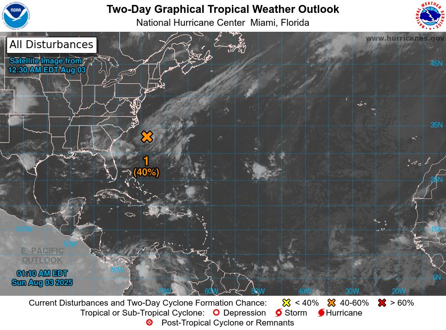
Atlantic 2-Day Graphical Outlook Image

Atlantic 7-Day Graphical Outlook Image
NHC Atlantic Outlook update for Sun, 03 Aug 2025 05:10:47 UTC
Additional Details Here.
03.08.2025 05:20 — 👍 12 🔁 3 💬 0 📌 0
ZCZC MIATWOAT ALL<br>TTAA00 KNHC DDHHMM<br><br>Tropical Weather Outlook<br>NWS National Hurricane Center Miami FL<br>800 PM EDT Sat Aug 2 2025<br><br>For the North Atlantic...Caribbean Sea and the Gulf of America:<br><br>1. Western Atlantic:<br>A non-tropical area of low pressure has formed along a frontal <br>boundary about 150 miles off the coast of North Carolina. This <br>system could acquire some tropical or subtropical characteristics <br>through Monday while it moves east-northeastward at about 10 mph <br>away from the coast of North Carolina. Environmental conditions <br>become less conducive for development after Monday.<br>* Formation chance through 48 hours...low...30 percent.<br>* Formation chance through 7 days...low...30 percent.<br><br>2. Central Tropical Atlantic:<br>A tropical wave is forecast to move off the west coast of Africa in <br>the next day or two. Environmental conditions could support some <br>gradual development of the wave during the middle to latter part of <br>next week while it moves generally west-northwestward across the <br>central tropical Atlantic.<br>* Formation chance through 48 hours...low...near 0 percent.<br>* Formation chance through 7 days...low...20 percent.<br><br><br><br>Forecaster Berg<br><br><br>
Atlantic 2-Day Graphical Outlook Image
Atlantic 7-Day Graphical Outlook Image
NHC Atlantic Outlook update for Sat, 02 Aug 2025 23:30:31 UTC
Additional Details Here.
02.08.2025 23:40 — 👍 13 🔁 10 💬 0 📌 1
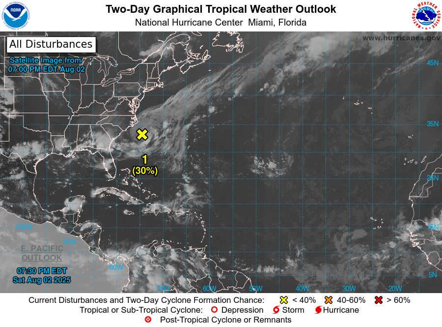
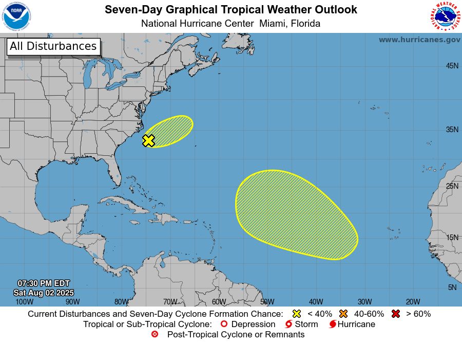
ZCZC MIATWOAT ALL<br>TTAA00 KNHC DDHHMM<br><br>Tropical Weather Outlook<br>NWS National Hurricane Center Miami FL<br>200 PM EDT Sat Aug 2 2025<br><br>For the North Atlantic...Caribbean Sea and the Gulf of America:<br><br>1. Western Atlantic:<br>An area of low pressure is expected to form tonight or on Sunday <br>along a frontal system off of the southeastern coast of the United <br>States. Additional slow development could occur through Monday as <br>the system moves slowly east-northeastward. After that time, <br>environmental conditions become less conducive for development.<br>* Formation chance through 48 hours...low...30 percent.<br>* Formation chance through 7 days...low...30 percent.<br><br><br><br>Forecaster Beven<br><br><br>
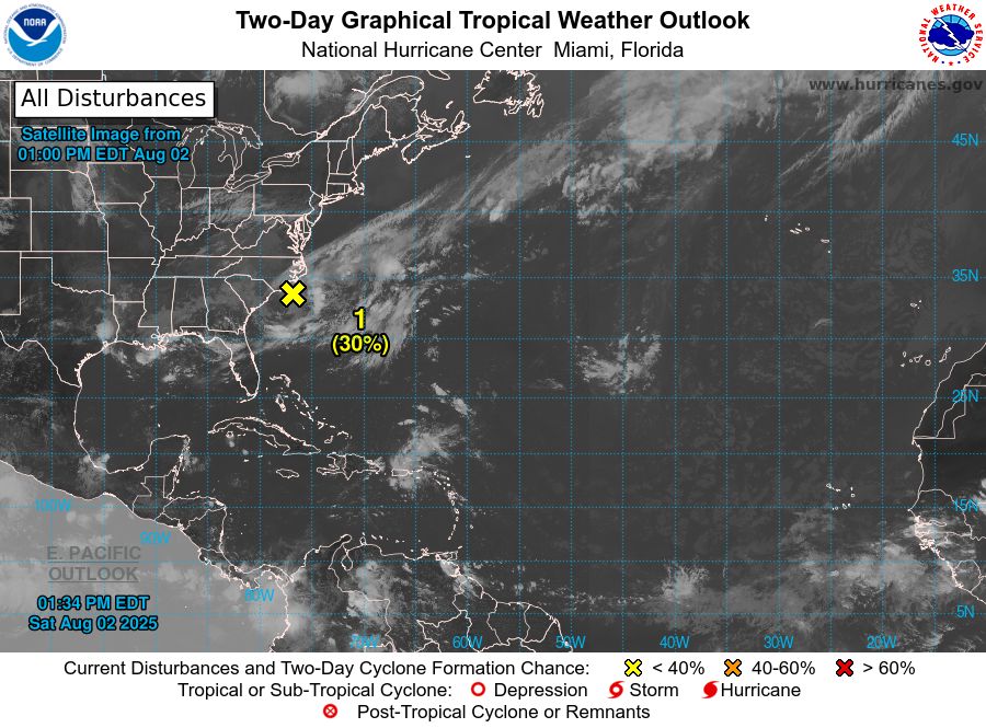
Atlantic 2-Day Graphical Outlook Image

Atlantic 7-Day Graphical Outlook Image
NHC Atlantic Outlook update for Sat, 02 Aug 2025 17:34:58 UTC
Additional Details Here.
02.08.2025 17:40 — 👍 9 🔁 4 💬 0 📌 0
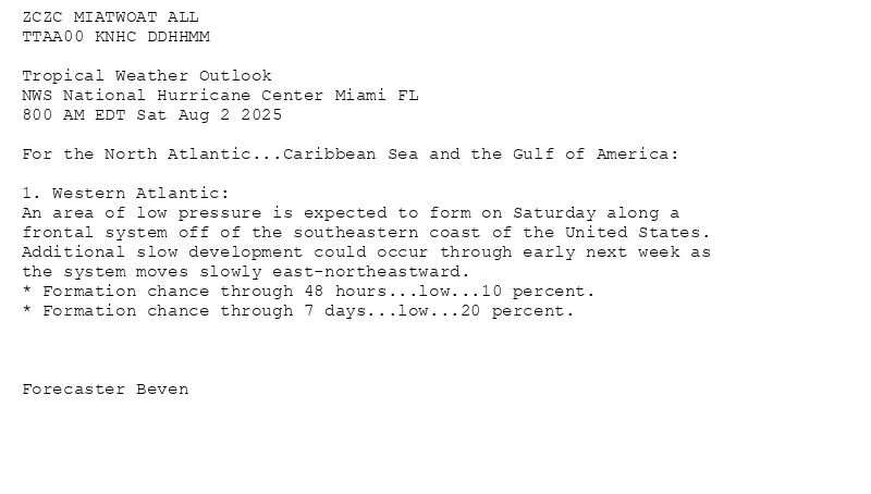
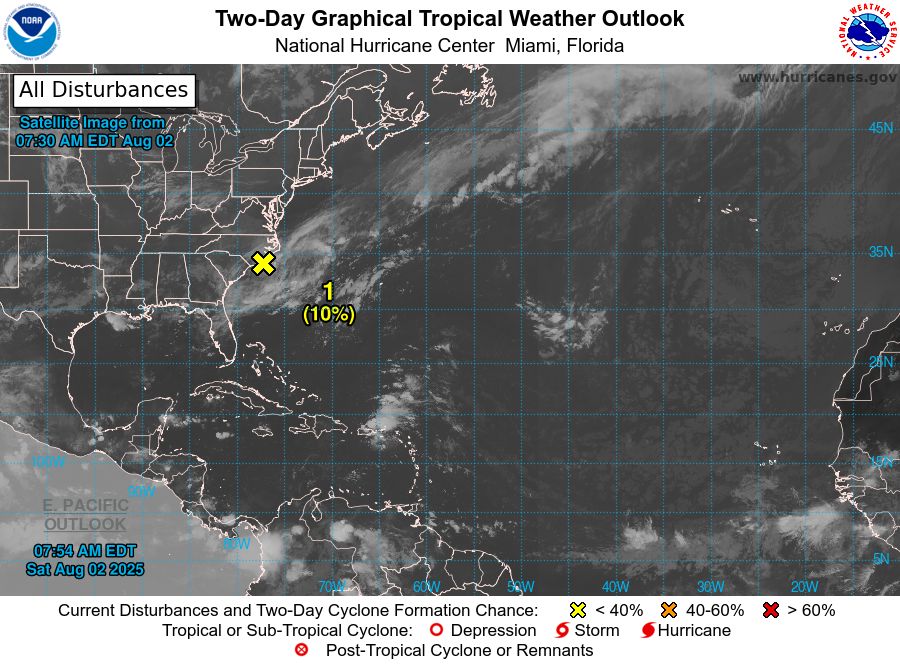
ZCZC MIATWOAT ALL<br>TTAA00 KNHC DDHHMM<br><br>Tropical Weather Outlook<br>NWS National Hurricane Center Miami FL<br>800 AM EDT Sat Aug 2 2025<br><br>For the North Atlantic...Caribbean Sea and the Gulf of America:<br><br>1. Western Atlantic:<br>An area of low pressure is expected to form on Saturday along a <br>frontal system off of the southeastern coast of the United States. <br>Additional slow development could occur through early next week as <br>the system moves slowly east-northeastward.<br>* Formation chance through 48 hours...low...10 percent.<br>* Formation chance through 7 days...low...20 percent.<br><br><br><br>Forecaster Beven<br><br><br>
Atlantic 2-Day Graphical Outlook Image
Atlantic 7-Day Graphical Outlook Image
NHC Atlantic Outlook update for Sat, 02 Aug 2025 11:54:58 UTC
Additional Details Here.
02.08.2025 12:00 — 👍 15 🔁 6 💬 0 📌 0

ZCZC MIATWOAT ALL<br>TTAA00 KNHC DDHHMM<br><br>Tropical Weather Outlook<br>NWS National Hurricane Center Miami FL<br>200 AM EDT Sat Aug 2 2025<br><br>For the North Atlantic...Caribbean Sea and the Gulf of America:<br><br>Tropical cyclone formation is not expected during the next 7 days.<br><br>$$<br>Forecaster Gibbs<br>NNNN<br><br><br>
Atlantic 2-Day Graphical Outlook Image

Atlantic 7-Day Graphical Outlook Image
NHC Atlantic Outlook update for Sat, 02 Aug 2025 05:09:01 UTC
Additional Details Here.
02.08.2025 05:10 — 👍 4 🔁 1 💬 0 📌 0

ZCZC MIATWOAT ALL<br>TTAA00 KNHC DDHHMM<br><br>Tropical Weather Outlook<br>NWS National Hurricane Center Miami FL<br>800 PM EDT Fri Aug 1 2025<br><br>For the North Atlantic...Caribbean Sea and the Gulf of America:<br><br>Tropical cyclone formation is not expected during the next 7 days.<br><br>$$<br>Forecaster Berg<br>NNNN<br><br><br>
Atlantic 2-Day Graphical Outlook Image
Atlantic 7-Day Graphical Outlook Image
NHC Atlantic Outlook update for Fri, 01 Aug 2025 23:29:42 UTC
Additional Details Here.
01.08.2025 23:40 — 👍 6 🔁 3 💬 1 📌 0
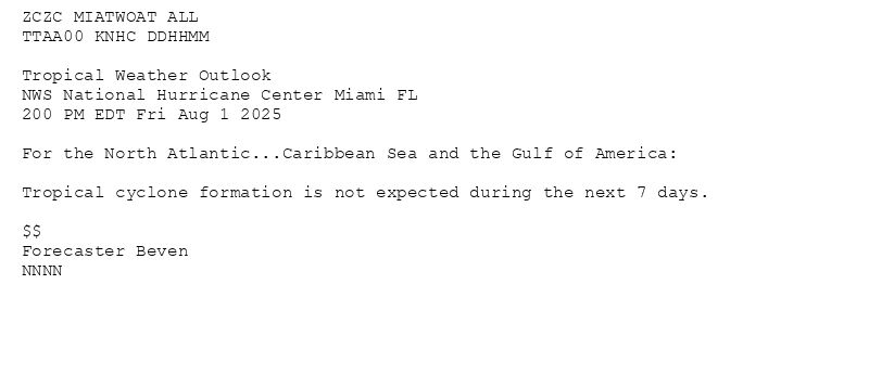
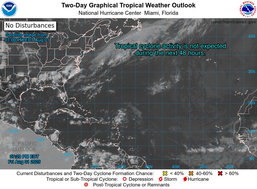
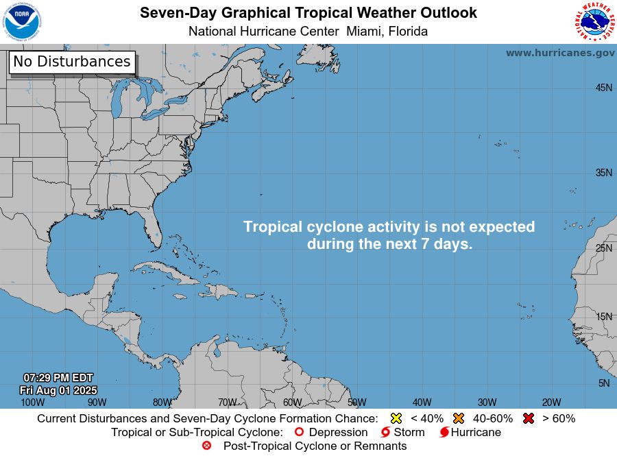
ZCZC MIATWOAT ALL<br>TTAA00 KNHC DDHHMM<br><br>Tropical Weather Outlook<br>NWS National Hurricane Center Miami FL<br>200 PM EDT Fri Aug 1 2025<br><br>For the North Atlantic...Caribbean Sea and the Gulf of America:<br><br>Tropical cyclone formation is not expected during the next 7 days.<br><br>$$<br>Forecaster Beven<br>NNNN<br><br><br>
Atlantic 2-Day Graphical Outlook Image

Atlantic 7-Day Graphical Outlook Image
NHC Atlantic Outlook update for Fri, 01 Aug 2025 17:38:42 UTC
Additional Details Here.
01.08.2025 17:40 — 👍 7 🔁 2 💬 1 📌 0
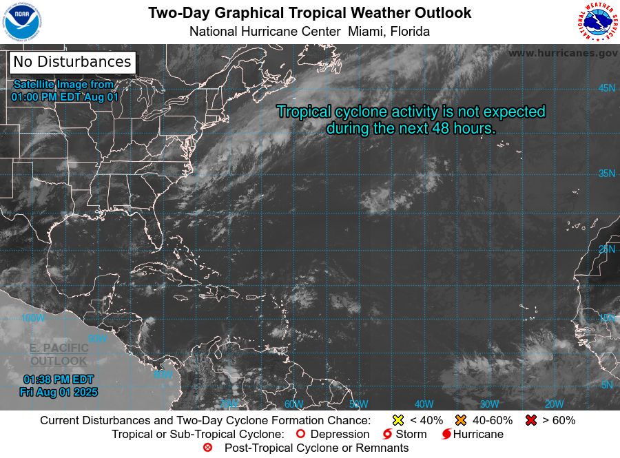
ZCZC MIATWOAT ALL<br>TTAA00 KNHC DDHHMM<br><br>Tropical Weather Outlook<br>NWS National Hurricane Center Miami FL<br>800 AM EDT Fri Aug 1 2025<br><br>For the North Atlantic...Caribbean Sea and the Gulf of America:<br><br>Tropical cyclone formation is not expected during the next 7 days.<br><br>$$<br>Forecaster Beven<br><br>NNNN<br><br><br>
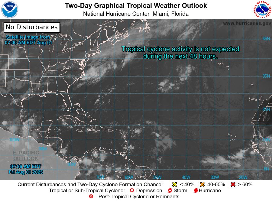
Atlantic 2-Day Graphical Outlook Image

Atlantic 7-Day Graphical Outlook Image
NHC Atlantic Outlook update for Fri, 01 Aug 2025 11:36:28 UTC
Additional Details Here.
01.08.2025 11:40 — 👍 7 🔁 2 💬 0 📌 0

ZCZC MIATWOAT ALL<br>TTAA00 KNHC DDHHMM<br><br>Tropical Weather Outlook<br>NWS National Hurricane Center Miami FL<br>200 AM EDT Fri Aug 1 2025<br><br>For the North Atlantic...Caribbean Sea and the Gulf of America:<br><br>Tropical cyclone formation is not expected during the next 7 days.<br><br>$$<br>Forecaster Hagen<br>NNNN<br><br><br>
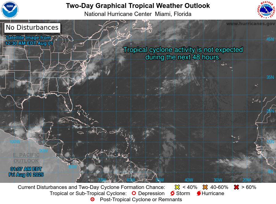
Atlantic 2-Day Graphical Outlook Image

Atlantic 7-Day Graphical Outlook Image
NHC Atlantic Outlook update for Fri, 01 Aug 2025 05:07:57 UTC
Additional Details Here.
01.08.2025 05:10 — 👍 3 🔁 2 💬 0 📌 0

ZCZC MIATWOAT ALL<br>TTAA00 KNHC DDHHMM<br><br>Tropical Weather Outlook<br>NWS National Hurricane Center Miami FL<br>800 PM EDT Thu Jul 31 2025<br><br>For the North Atlantic...Caribbean Sea and the Gulf of America:<br><br>Tropical cyclone formation is not expected during the next 7 days.<br><br>$$<br>Forecaster Pasch<br>NNNN<br><br><br>
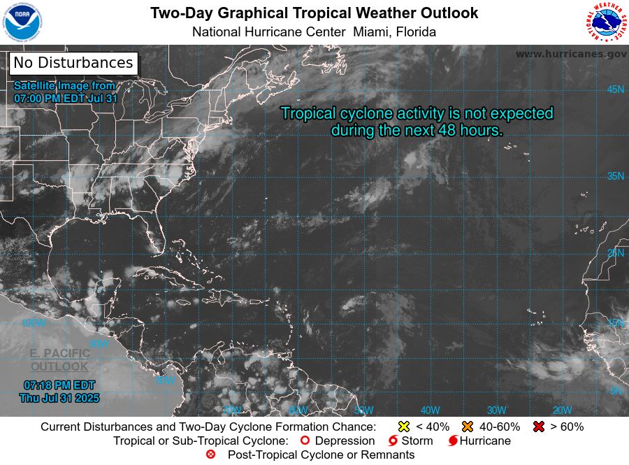
Atlantic 2-Day Graphical Outlook Image

Atlantic 7-Day Graphical Outlook Image
NHC Atlantic Outlook update for Thu, 31 Jul 2025 23:18:29 UTC
Additional Details Here.
31.07.2025 23:20 — 👍 2 🔁 2 💬 1 📌 0
ZCZC MIATWOAT ALL<br>TTAA00 KNHC DDHHMM<br><br>Tropical Weather Outlook<br>NWS National Hurricane Center Miami FL<br>200 PM EDT Thu Jul 31 2025<br><br>For the North Atlantic...Caribbean Sea and the Gulf of America:<br><br>Tropical cyclone formation is not expected during the next 7 days.<br><br>$$<br>Forecaster Beven<br><br>NNNN<br><br><br>
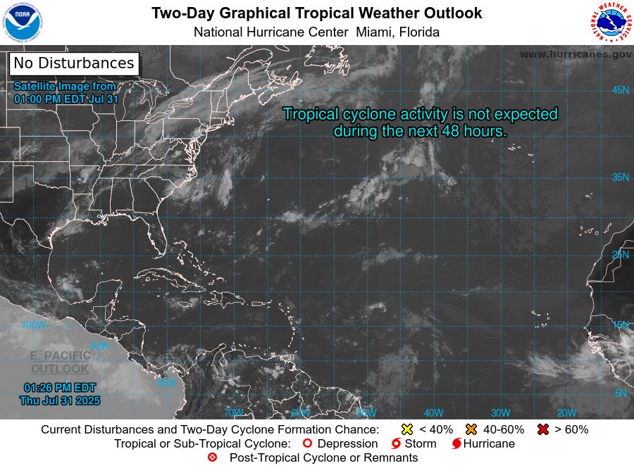
Atlantic 2-Day Graphical Outlook Image

Atlantic 7-Day Graphical Outlook Image
NHC Atlantic Outlook update for Thu, 31 Jul 2025 17:26:29 UTC
Additional Details Here.
31.07.2025 17:30 — 👍 3 🔁 2 💬 0 📌 0

ZCZC MIATWOAT ALL<br>TTAA00 KNHC DDHHMM<br><br>Tropical Weather Outlook<br>NWS National Hurricane Center Miami FL<br>800 AM EDT Thu Jul 31 2025<br><br>For the North Atlantic...Caribbean Sea and the Gulf of America:<br><br>Tropical cyclone formation is not expected during the next 7 days.<br><br>$$<br>Forecaster Beven<br>NNNN<br><br><br>
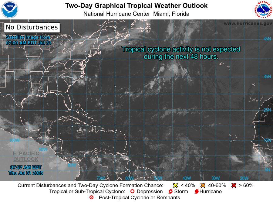
Atlantic 2-Day Graphical Outlook Image

Atlantic 7-Day Graphical Outlook Image
NHC Atlantic Outlook update for Thu, 31 Jul 2025 11:37:46 UTC
Additional Details Here.
31.07.2025 11:40 — 👍 5 🔁 1 💬 0 📌 0
ZCZC MIATWOAT ALL<br>TTAA00 KNHC DDHHMM<br><br>Tropical Weather Outlook<br>NWS National Hurricane Center Miami FL<br>200 AM EDT Thu Jul 31 2025<br><br>For the North Atlantic...Caribbean Sea and the Gulf of America:<br><br>Tropical cyclone formation is not expected during the next 7 days.<br><br>$$<br>Forecaster Hagen<br>NNNN<br><br><br>
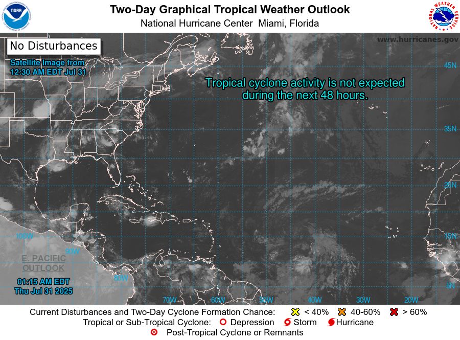
Atlantic 2-Day Graphical Outlook Image

Atlantic 7-Day Graphical Outlook Image
NHC Atlantic Outlook update for Thu, 31 Jul 2025 05:16:05 UTC
Additional Details Here.
31.07.2025 05:20 — 👍 4 🔁 1 💬 0 📌 0

ZCZC MIATWOAT ALL<br>TTAA00 KNHC DDHHMM<br><br>Tropical Weather Outlook<br>NWS National Hurricane Center Miami FL<br>800 PM EDT Wed Jul 30 2025<br><br>For the North Atlantic...Caribbean Sea and the Gulf of America:<br><br>Tropical cyclone formation is not expected during the next 7 days.<br><br>$$<br>Forecaster Pasch<br>NNNN<br><br><br>
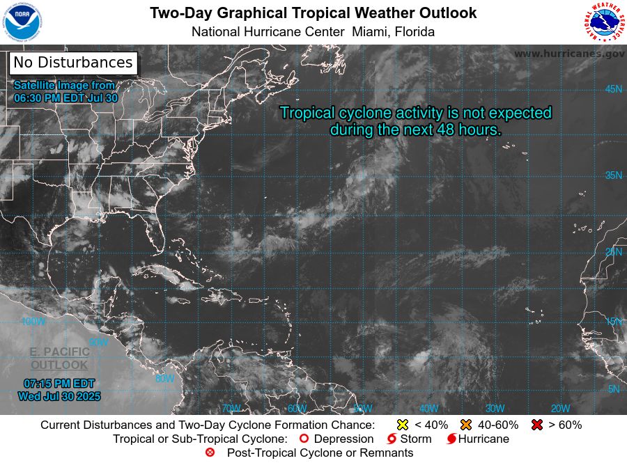
Atlantic 2-Day Graphical Outlook Image

Atlantic 7-Day Graphical Outlook Image
NHC Atlantic Outlook update for Wed, 30 Jul 2025 23:15:47 UTC
Additional Details Here.
30.07.2025 23:20 — 👍 9 🔁 3 💬 1 📌 0

ZCZC MIATWOAT ALL<br>TTAA00 KNHC DDHHMM<br><br>Tropical Weather Outlook<br>NWS National Hurricane Center Miami FL<br>200 PM EDT Wed Jul 30 2025<br><br>For the North Atlantic...Caribbean Sea and the Gulf of America:<br><br>Tropical cyclone formation is not expected during the next 7 days.<br><br>$$<br>Forecaster Bucci<br>NNNN<br><br><br>

Atlantic 2-Day Graphical Outlook Image

Atlantic 7-Day Graphical Outlook Image
NHC Atlantic Outlook update for Wed, 30 Jul 2025 17:52:16 UTC
Additional Details Here.
30.07.2025 18:00 — 👍 6 🔁 3 💬 0 📌 0

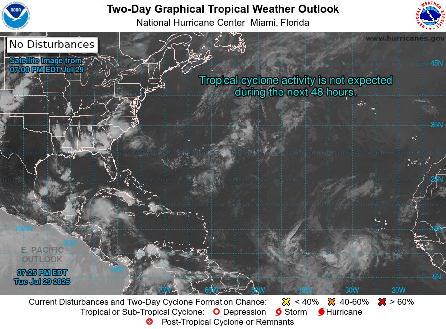
ZCZC MIATWOAT ALL<br>TTAA00 KNHC DDHHMM<br><br>Tropical Weather Outlook<br>NWS National Hurricane Center Miami FL<br>800 AM EDT Wed Jul 30 2025<br><br>For the North Atlantic...Caribbean Sea and the Gulf of America:<br><br>Tropical cyclone formation is not expected during the next 7 days.<br><br>$$<br>Forecaster Bucci<br>NNNN<br><br><br>
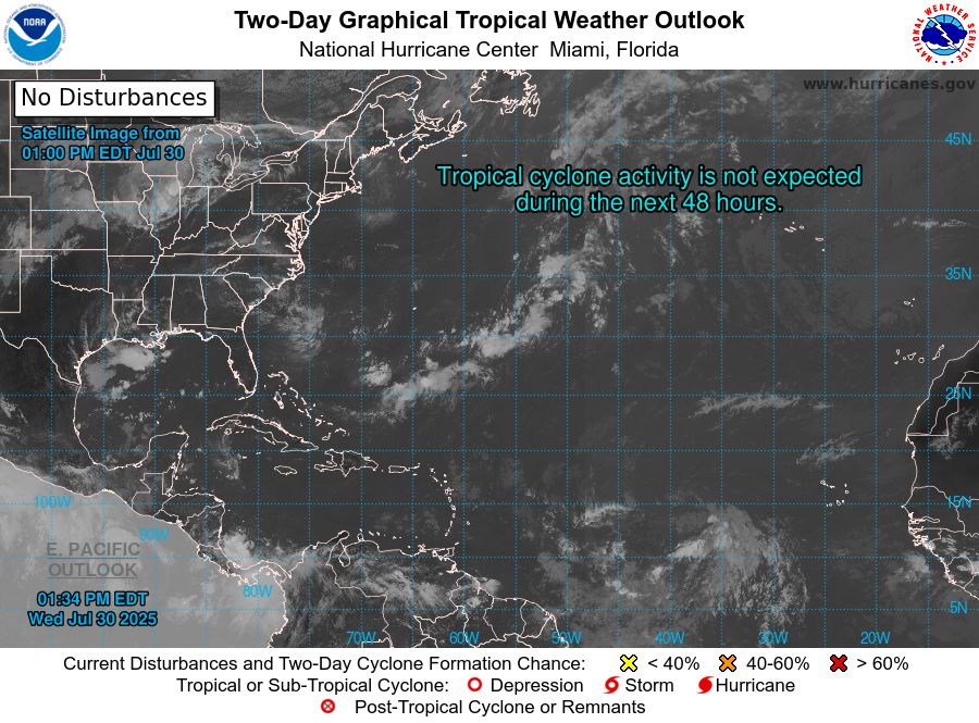
Atlantic 2-Day Graphical Outlook Image

Atlantic 7-Day Graphical Outlook Image
NHC Atlantic Outlook update for Wed, 30 Jul 2025 17:35:03 UTC
Additional Details Here.
30.07.2025 17:40 — 👍 3 🔁 2 💬 0 📌 0
ZCZC MIATWOAT ALL<br>TTAA00 KNHC DDHHMM<br><br>Tropical Weather Outlook<br>NWS National Hurricane Center Miami FL<br>800 AM EDT Wed Jul 30 2025<br><br>For the North Atlantic...Caribbean Sea and the Gulf of America:<br><br>Tropical cyclone formation is not expected during the next 7 days.<br><br>$$<br>Forecaster Bucci<br>NNNN<br><br><br>
Atlantic 2-Day Graphical Outlook Image

Atlantic 7-Day Graphical Outlook Image
NHC Atlantic Outlook update for Wed, 30 Jul 2025 11:33:26 UTC
Additional Details Here.
30.07.2025 11:40 — 👍 6 🔁 2 💬 0 📌 0
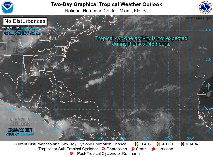
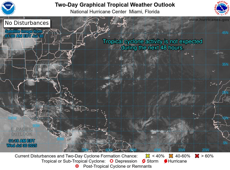
ZCZC MIATWOAT ALL<br>TTAA00 KNHC DDHHMM<br><br>Tropical Weather Outlook<br>NWS National Hurricane Center Miami FL<br>200 AM EDT Wed Jul 30 2025<br><br>For the North Atlantic...Caribbean Sea and the Gulf of America:<br><br>Tropical cyclone formation is not expected during the next 7 days.<br><br>$$<br>Forecaster Hagen<br>NNNN<br><br><br>
Atlantic 2-Day Graphical Outlook Image

Atlantic 7-Day Graphical Outlook Image
NHC Atlantic Outlook update for Wed, 30 Jul 2025 05:18:46 UTC
Additional Details Here.
30.07.2025 05:20 — 👍 7 🔁 2 💬 0 📌 0

ZCZC MIATWOAT ALL<br>TTAA00 KNHC DDHHMM<br><br>Tropical Weather Outlook<br>NWS National Hurricane Center Miami FL<br>800 PM EDT Tue Jul 29 2025<br><br>For the North Atlantic...Caribbean Sea and the Gulf of America:<br><br>Tropical cyclone formation is not expected during the next 7 days.<br><br>$$<br>Forecaster Pasch<br>NNNN<br><br><br>
Atlantic 2-Day Graphical Outlook Image

Atlantic 7-Day Graphical Outlook Image
NHC Atlantic Outlook update for Tue, 29 Jul 2025 23:25:29 UTC
Additional Details Here.
29.07.2025 23:30 — 👍 9 🔁 7 💬 0 📌 0

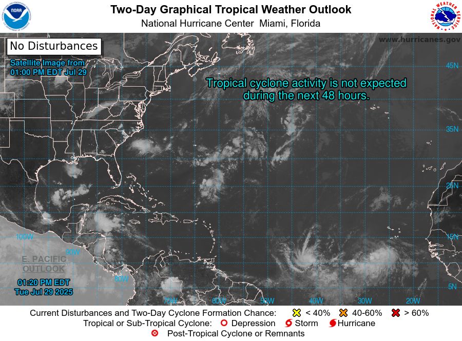
ZCZC MIATWOAT ALL<br>TTAA00 KNHC DDHHMM<br><br>Tropical Weather Outlook<br>NWS National Hurricane Center Miami FL<br>200 PM EDT Tue Jul 29 2025<br><br>For the North Atlantic...Caribbean Sea and the Gulf of America:<br><br>Tropical cyclone formation is not expected during the next 7 days.<br><br>$$<br>Forecaster Bucci<br>NNNN<br><br><br>
Atlantic 2-Day Graphical Outlook Image

Atlantic 7-Day Graphical Outlook Image
NHC Atlantic Outlook update for Tue, 29 Jul 2025 17:20:46 UTC
Additional Details Here.
29.07.2025 17:30 — 👍 5 🔁 3 💬 0 📌 0

ZCZC MIATWOAT ALL<br>TTAA00 KNHC DDHHMM<br><br>Tropical Weather Outlook<br>NWS National Hurricane Center Miami FL<br>800 AM EDT Tue Jul 29 2025<br><br>For the North Atlantic...Caribbean Sea and the Gulf of America:<br><br>Tropical cyclone formation is not expected during the next 7 days.<br><br>$$<br>Forecaster Bucci<br>NNNN<br><br><br>
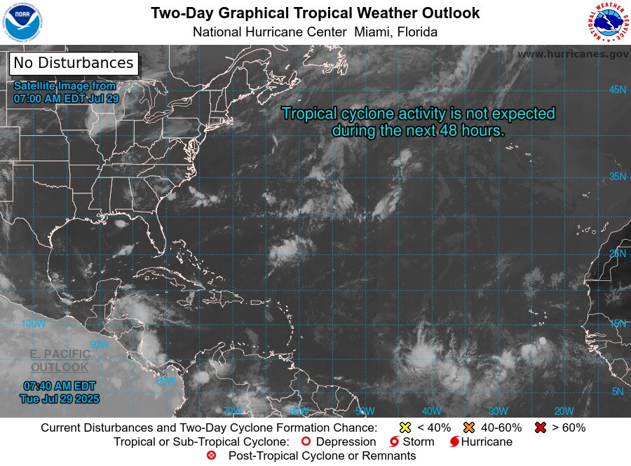
Atlantic 2-Day Graphical Outlook Image

Atlantic 7-Day Graphical Outlook Image
NHC Atlantic Outlook update for Tue, 29 Jul 2025 11:41:02 UTC
Additional Details Here.
29.07.2025 11:50 — 👍 5 🔁 2 💬 0 📌 0
ZCZC MIATWOAT ALL<br>TTAA00 KNHC DDHHMM<br><br>Tropical Weather Outlook<br>NWS National Hurricane Center Miami FL<br>200 AM EDT Tue Jul 29 2025<br><br>For the North Atlantic...Caribbean Sea and the Gulf of America:<br><br>Tropical cyclone formation is not expected during the next 7 days.<br><br>$$<br>Forecaster Kelly<br>NNNN<br><br><br>
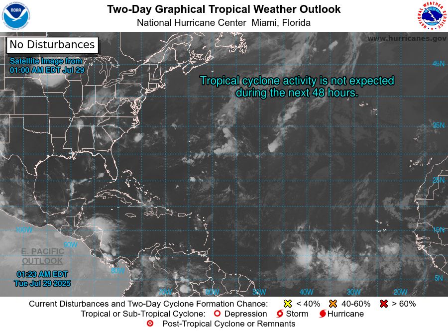
Atlantic 2-Day Graphical Outlook Image

Atlantic 7-Day Graphical Outlook Image
NHC Atlantic Outlook update for Tue, 29 Jul 2025 05:24:08 UTC
Additional Details Here.
29.07.2025 05:30 — 👍 6 🔁 3 💬 0 📌 0

