DULUTH Aug 9
Climate Report:
High: 80
Low: 73
Precip: Trace
Snow: 0.0" Snow Depth: 0"
at Sat, 09 Aug 2025 21:29:50 +0000 via IEMbot
Additional Details Here.
09.08.2025 21:48 — 👍 0 🔁 0 💬 0 📌 0
DLH issues Area Forecast Discussion (AFD) at Aug 9, 3:32 PM CDT
at Sat, 09 Aug 2025 20:33:45 +0000 via IEMbot
Additional Details Here.
09.08.2025 20:48 — 👍 0 🔁 0 💬 0 📌 0
DLH issues Hazardous Weather Outlook (HWO) at Aug 9, 3:09 PM CDT
at Sat, 09 Aug 2025 20:10:04 +0000 via IEMbot
Additional Details Here.
09.08.2025 20:27 — 👍 0 🔁 0 💬 0 📌 0
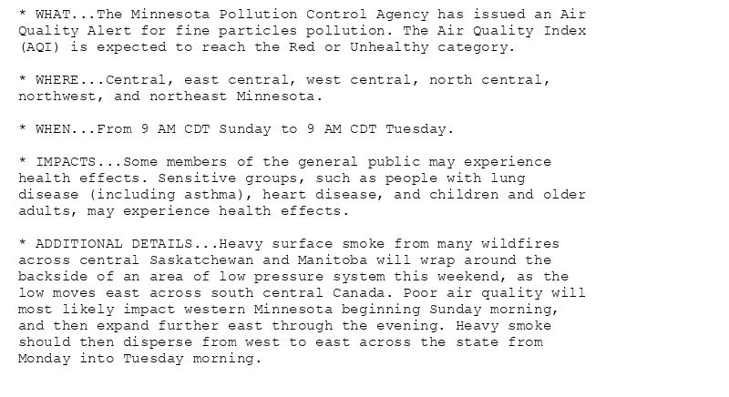
* WHAT...The Minnesota Pollution Control Agency has issued an Air
Quality Alert for fine particles pollution. The Air Quality Index
(AQI) is expected to reach the Red or Unhealthy category.
* WHERE...Central, east central, west central, north central,
northwest, and northeast Minnesota.
* WHEN...From 9 AM CDT Sunday to 9 AM CDT Tuesday.
* IMPACTS...Some members of the general public may experience
health effects. Sensitive groups, such as people with lung
disease (including asthma), heart disease, and children and older
adults, may experience health effects.
* ADDITIONAL DETAILS...Heavy surface smoke from many wildfires
across central Saskatchewan and Manitoba will wrap around the
backside of an area of low pressure system this weekend, as the
low moves east across south central Canada. Poor air quality will
most likely impact western Minnesota beginning Sunday morning,
and then expand further east through the evening. Heavy smoke
should then disperse from west to east across the state from
Monday into Tuesday morning.
Air Quality Alert issued August 9 at 1:20PM CDT by NWS Duluth MN
Additional Details Here.
09.08.2025 18:30 — 👍 0 🔁 0 💬 0 📌 1
DLH issues Air Quality Alert (AQA) at Aug 9, 1:20 PM CDT ...AIR QUALITY ALERT IN EFFECT FROM 9 AM CDT SUNDAY TO 9 AM CDT TUESDAY... via IEMbot
Additional Details Here.
09.08.2025 18:27 — 👍 1 🔁 0 💬 1 📌 0
DLH issues Area Forecast Discussion (AFD) at Aug 9, 12:40 PM CDT
at Sat, 09 Aug 2025 17:40:40 +0000 via IEMbot
Additional Details Here.
09.08.2025 17:48 — 👍 0 🔁 0 💬 0 📌 0
DLH expires Flash Flood Warning for Cook [MN]
at Sat, 09 Aug 2025 17:12:31 +0000 via IEMbot
Additional Details Here.
09.08.2025 17:28 — 👍 0 🔁 0 💬 0 📌 0
DLH expires Flood Advisory for Cook, Lake, St. Louis [MN]
at Sat, 09 Aug 2025 16:08:00 +0000 via IEMbot
Additional Details Here.
09.08.2025 16:28 — 👍 0 🔁 0 💬 0 📌 0
3 E Grand Marais [Cook Co, MN] Public reports Rain of 1.25 Inch at 9:00 AM CDT --
at Sat, 09 Aug 2025 16:11:26 +0000 via IEMbot
Additional Details Here.
09.08.2025 16:28 — 👍 0 🔁 0 💬 0 📌 0
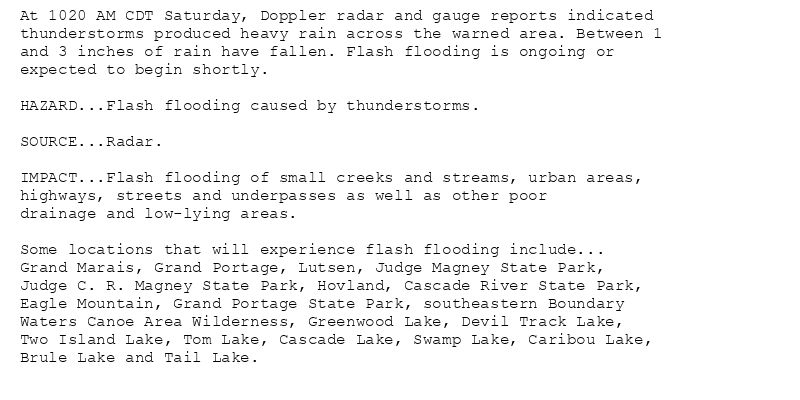
At 1020 AM CDT Saturday, Doppler radar and gauge reports indicated
thunderstorms produced heavy rain across the warned area. Between 1
and 3 inches of rain have fallen. Flash flooding is ongoing or
expected to begin shortly.
HAZARD...Flash flooding caused by thunderstorms.
SOURCE...Radar.
IMPACT...Flash flooding of small creeks and streams, urban areas,
highways, streets and underpasses as well as other poor
drainage and low-lying areas.
Some locations that will experience flash flooding include...
Grand Marais, Grand Portage, Lutsen, Judge Magney State Park,
Judge C. R. Magney State Park, Hovland, Cascade River State Park,
Eagle Mountain, Grand Portage State Park, southeastern Boundary
Waters Canoe Area Wilderness, Greenwood Lake, Devil Track Lake,
Two Island Lake, Tom Lake, Cascade Lake, Swamp Lake, Caribou Lake,
Brule Lake and Tail Lake.
🚨 Flash Flood Warning issued August 9 at 10:20AM CDT until August 9 at 12:15PM CDT by NWS Duluth MN 🚨
Additional Details Here.
09.08.2025 15:30 — 👍 2 🔁 0 💬 0 📌 0
DLH continues Flash Flood Warning [flash flood: radar indicated] for Cook [MN] till Aug 9, 12:15 PM CDT
at Sat, 09 Aug 2025 15:20:55 +0000 via IEMbot
Additional Details Here.
09.08.2025 15:27 — 👍 0 🔁 0 💬 0 📌 0
Weather Prediction Center issues Mesoscale Precipitation Discussion #885 concerning HEAVY RAINFALL...FLASH FLOODING LIKELY
at Sat, 09 Aug 2025 14:32:00 +0000 via IEMbot
Additional Details Here.
09.08.2025 14:48 — 👍 0 🔁 0 💬 0 📌 0
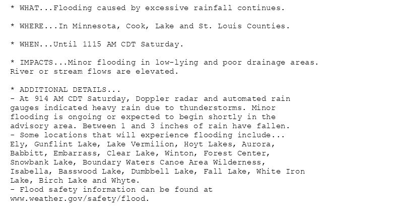
* WHAT...Flooding caused by excessive rainfall continues.
* WHERE...In Minnesota, Cook, Lake and St. Louis Counties.
* WHEN...Until 1115 AM CDT Saturday.
* IMPACTS...Minor flooding in low-lying and poor drainage areas.
River or stream flows are elevated.
* ADDITIONAL DETAILS...
- At 914 AM CDT Saturday, Doppler radar and automated rain
gauges indicated heavy rain due to thunderstorms. Minor
flooding is ongoing or expected to begin shortly in the
advisory area. Between 1 and 3 inches of rain have fallen.
- Some locations that will experience flooding include...
Ely, Gunflint Lake, Lake Vermilion, Hoyt Lakes, Aurora,
Babbitt, Embarrass, Clear Lake, Winton, Forest Center,
Snowbank Lake, Boundary Waters Canoe Area Wilderness,
Isabella, Basswood Lake, Dumbbell Lake, Fall Lake, White Iron
Lake, Birch Lake and Whyte.
- Flood safety information can be found at
www.weather.gov/safety/flood.
Flood Advisory issued August 9 at 9:14AM CDT until August 9 at 11:15AM CDT by NWS Duluth MN
Additional Details Here.
09.08.2025 14:30 — 👍 0 🔁 0 💬 0 📌 0
DLH continues Flood Advisory for Cook, Lake, St. Louis [MN] till Aug 9, 11:15 AM CDT
at Sat, 09 Aug 2025 14:15:23 +0000 via IEMbot
Additional Details Here.
09.08.2025 14:28 — 👍 0 🔁 0 💬 0 📌 0
DLH cancels Marine Warning for Grand Portage to Grand Marais MN, Lake Superior west of a line from Saxon Harbor WI to Grand Portage MN beyond 5NM [LS]
at Sat, 09 Aug 2025 13:48:55 +0000 via IEMbot
Additional Details Here.
09.08.2025 14:07 — 👍 0 🔁 0 💬 0 📌 0
1 SSE Shell Lake [Washburn Co, WI] Public reports Tstm Wnd Dmg at 4:40 AM CDT -- Photos were received via social media showing trees down with one uprooted and down over the road n... at Sat, 09 Aug 2025 13:28:52 +0000 via IEMbot
Additional Details Here.
09.08.2025 13:47 — 👍 0 🔁 0 💬 0 📌 0
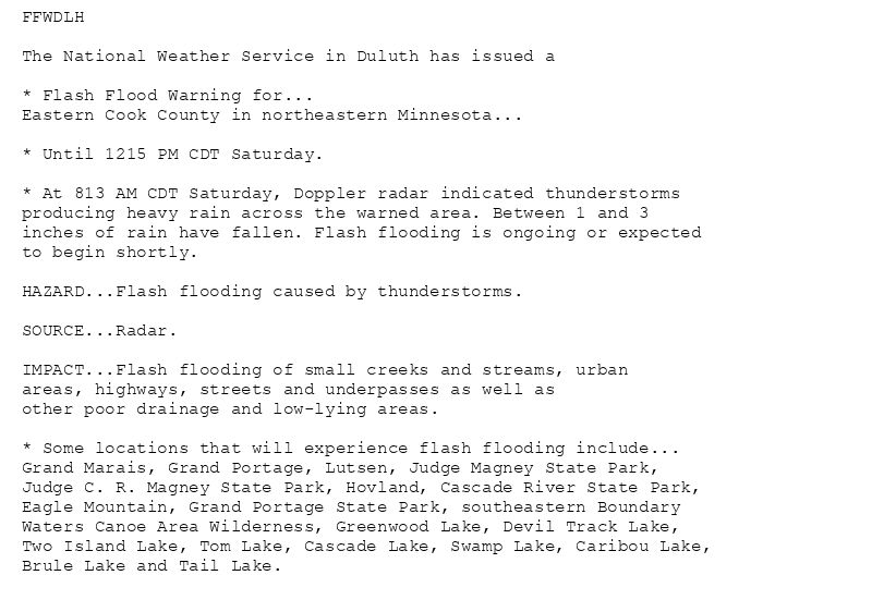
FFWDLH
The National Weather Service in Duluth has issued a
* Flash Flood Warning for...
Eastern Cook County in northeastern Minnesota...
* Until 1215 PM CDT Saturday.
* At 813 AM CDT Saturday, Doppler radar indicated thunderstorms
producing heavy rain across the warned area. Between 1 and 3
inches of rain have fallen. Flash flooding is ongoing or expected
to begin shortly.
HAZARD...Flash flooding caused by thunderstorms.
SOURCE...Radar.
IMPACT...Flash flooding of small creeks and streams, urban
areas, highways, streets and underpasses as well as
other poor drainage and low-lying areas.
* Some locations that will experience flash flooding include...
Grand Marais, Grand Portage, Lutsen, Judge Magney State Park,
Judge C. R. Magney State Park, Hovland, Cascade River State Park,
Eagle Mountain, Grand Portage State Park, southeastern Boundary
Waters Canoe Area Wilderness, Greenwood Lake, Devil Track Lake,
Two Island Lake, Tom Lake, Cascade Lake, Swamp Lake, Caribou Lake,
Brule Lake and Tail Lake.
🚨 Flash Flood Warning issued August 9 at 8:13AM CDT until August 9 at 12:15PM CDT by NWS Duluth MN 🚨
Additional Details Here.
09.08.2025 13:30 — 👍 0 🔁 0 💬 0 📌 0
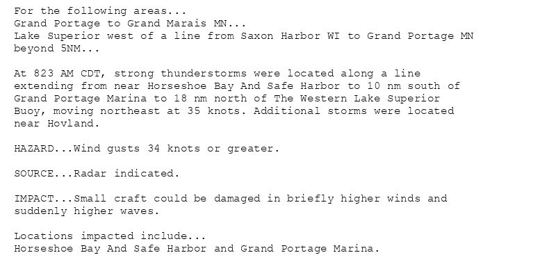
For the following areas...
Grand Portage to Grand Marais MN...
Lake Superior west of a line from Saxon Harbor WI to Grand Portage MN
beyond 5NM...
At 823 AM CDT, strong thunderstorms were located along a line
extending from near Horseshoe Bay And Safe Harbor to 10 nm south of
Grand Portage Marina to 18 nm north of The Western Lake Superior
Buoy, moving northeast at 35 knots. Additional storms were located
near Hovland.
HAZARD...Wind gusts 34 knots or greater.
SOURCE...Radar indicated.
IMPACT...Small craft could be damaged in briefly higher winds and
suddenly higher waves.
Locations impacted include...
Horseshoe Bay And Safe Harbor and Grand Portage Marina.
🚨 Special Marine Warning issued August 9 at 8:25AM CDT until August 9 at 9:15AM CDT by NWS Duluth MN 🚨
Additional Details Here.
09.08.2025 13:30 — 👍 0 🔁 0 💬 0 📌 0
DLH issues Flash Flood Warning [flash flood: radar indicated] for Cook [MN] till Aug 9, 12:15 PM CDT
at Sat, 09 Aug 2025 13:13:39 +0000 via IEMbot
Additional Details Here.
09.08.2025 13:28 — 👍 0 🔁 0 💬 0 📌 0
DLH updates Marine Warning [wind: >34 KTS, hail: 0.00 IN] (cancels Grand Marais to Taconite Harbor MN [LS], continues Grand Portage to Grand Marais MN, Lake Superior west of a l... at Sat, 09 Aug 2025 13:25:11 +0000 via IEMbot
Additional Details Here.
09.08.2025 13:27 — 👍 0 🔁 0 💬 0 📌 0
The Storm Prediction Center issues Day 1 Slight Convective Risk at Aug 9, 12:48z for portions of DLH
at Sat, 09 Aug 2025 12:49:47 +0000 via IEMbot
Additional Details Here.
09.08.2025 13:08 — 👍 0 🔁 0 💬 0 📌 0
DLH issues Marine Warning [wind: >34 KTS, hail: 0.00 IN] for Grand Marais to Taconite Harbor MN, Grand Portage to Grand Marais MN, Lake Superior west of a line from Saxon Harbor... at Sat, 09 Aug 2025 12:41:05 +0000 via IEMbot
Additional Details Here.
09.08.2025 12:47 — 👍 0 🔁 0 💬 0 📌 0
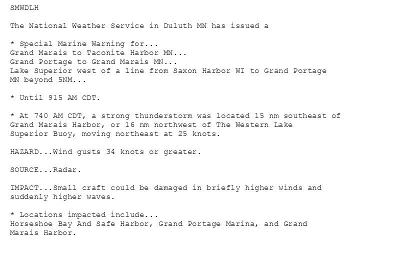
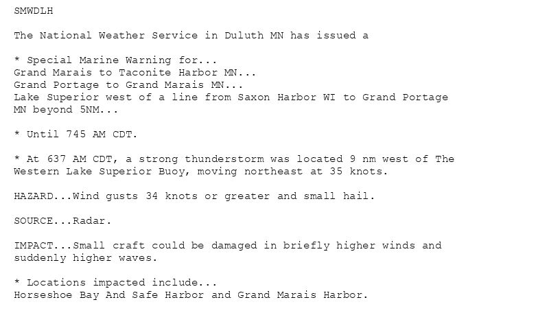
SMWDLH
The National Weather Service in Duluth MN has issued a
* Special Marine Warning for...
Grand Marais to Taconite Harbor MN...
Grand Portage to Grand Marais MN...
Lake Superior west of a line from Saxon Harbor WI to Grand Portage
MN beyond 5NM...
* Until 915 AM CDT.
* At 740 AM CDT, a strong thunderstorm was located 15 nm southeast of
Grand Marais Harbor, or 16 nm northwest of The Western Lake
Superior Buoy, moving northeast at 25 knots.
HAZARD...Wind gusts 34 knots or greater.
SOURCE...Radar.
IMPACT...Small craft could be damaged in briefly higher winds and
suddenly higher waves.
* Locations impacted include...
Horseshoe Bay And Safe Harbor, Grand Portage Marina, and Grand
Marais Harbor.
🚨 Special Marine Warning issued August 9 at 7:40AM CDT until August 9 at 9:15AM CDT by NWS Duluth MN 🚨
Additional Details Here.
09.08.2025 12:45 — 👍 0 🔁 0 💬 0 📌 0
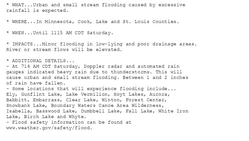
* WHAT...Urban and small stream flooding caused by excessive
rainfall is expected.
* WHERE...In Minnesota, Cook, Lake and St. Louis Counties.
* WHEN...Until 1115 AM CDT Saturday.
* IMPACTS...Minor flooding in low-lying and poor drainage areas.
River or stream flows will be elevated.
* ADDITIONAL DETAILS...
- At 714 AM CDT Saturday, Doppler radar and automated rain
gauges indicated heavy rain due to thunderstorms. This will
cause urban and small stream flooding. Between 1 and 2 inches
of rain have fallen.
- Some locations that will experience flooding include...
Ely, Gunflint Lake, Lake Vermilion, Hoyt Lakes, Aurora,
Babbitt, Embarrass, Clear Lake, Winton, Forest Center,
Snowbank Lake, Boundary Waters Canoe Area Wilderness,
Isabella, Basswood Lake, Dumbbell Lake, Fall Lake, White Iron
Lake, Birch Lake and Whyte.
- Flood safety information can be found at
www.weather.gov/safety/flood.
Flood Advisory issued August 9 at 7:15AM CDT until August 9 at 11:15AM CDT by NWS Duluth MN
Additional Details Here.
09.08.2025 12:30 — 👍 0 🔁 0 💬 0 📌 0
DLH continues Marine Warning [wind: >34 KTS, hail: <.75 IN] for Grand Marais to Taconite Harbor MN, Grand Portage to Grand Marais MN, Lake Superior west of a line from Saxon ... at Sat, 09 Aug 2025 12:14:06 +0000 via IEMbot
Additional Details Here.
09.08.2025 12:28 — 👍 0 🔁 0 💬 0 📌 0
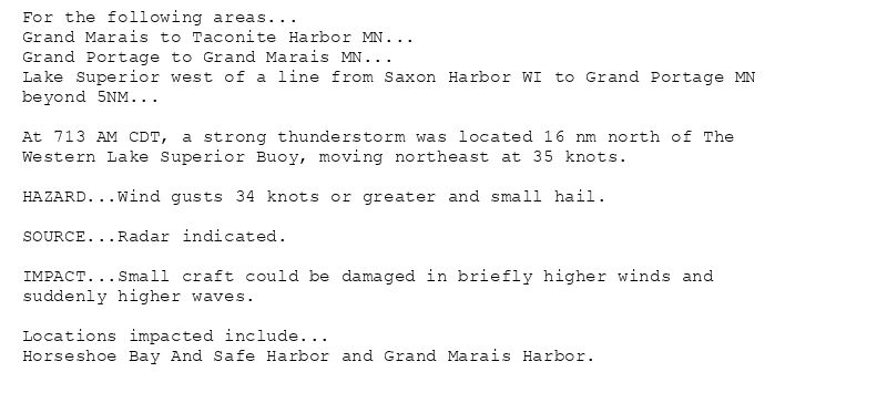
For the following areas...
Grand Marais to Taconite Harbor MN...
Grand Portage to Grand Marais MN...
Lake Superior west of a line from Saxon Harbor WI to Grand Portage MN
beyond 5NM...
At 713 AM CDT, a strong thunderstorm was located 16 nm north of The
Western Lake Superior Buoy, moving northeast at 35 knots.
HAZARD...Wind gusts 34 knots or greater and small hail.
SOURCE...Radar indicated.
IMPACT...Small craft could be damaged in briefly higher winds and
suddenly higher waves.
Locations impacted include...
Horseshoe Bay And Safe Harbor and Grand Marais Harbor.
🚨 Special Marine Warning issued August 9 at 7:13AM CDT until August 9 at 7:45AM CDT by NWS Duluth MN 🚨
Additional Details Here.
09.08.2025 12:15 — 👍 0 🔁 0 💬 0 📌 0
DLH continues Severe Thunderstorm Warning [wind: 60 MPH (RADAR INDICATED), hail: 0.75 IN (RADAR INDICATED)] for Cook, Lake [MN] till 7:15 AM CDT
at Sat, 09 Aug 2025 11:57:39 +0000 via IEMbot
Additional Details Here.
09.08.2025 12:08 — 👍 2 🔁 0 💬 0 📌 0
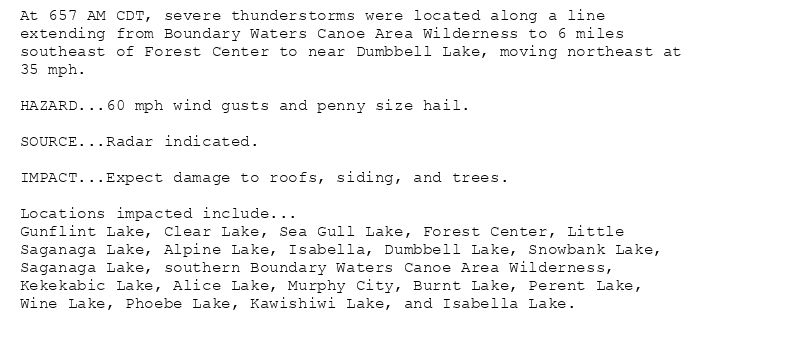
At 657 AM CDT, severe thunderstorms were located along a line
extending from Boundary Waters Canoe Area Wilderness to 6 miles
southeast of Forest Center to near Dumbbell Lake, moving northeast at
35 mph.
HAZARD...60 mph wind gusts and penny size hail.
SOURCE...Radar indicated.
IMPACT...Expect damage to roofs, siding, and trees.
Locations impacted include...
Gunflint Lake, Clear Lake, Sea Gull Lake, Forest Center, Little
Saganaga Lake, Alpine Lake, Isabella, Dumbbell Lake, Snowbank Lake,
Saganaga Lake, southern Boundary Waters Canoe Area Wilderness,
Kekekabic Lake, Alice Lake, Murphy City, Burnt Lake, Perent Lake,
Wine Lake, Phoebe Lake, Kawishiwi Lake, and Isabella Lake.
🚨 Severe Thunderstorm Warning issued August 9 at 6:57AM CDT until August 9 at 7:15AM CDT by NWS Duluth MN 🚨
Additional Details Here.
09.08.2025 12:00 — 👍 0 🔁 0 💬 0 📌 0
DLH issues Marine Warning [wind: >34 KTS, hail: <.75 IN] for Grand Marais to Taconite Harbor MN, Grand Portage to Grand Marais MN, Lake Superior west of a line from Saxon Har... at Sat, 09 Aug 2025 11:38:27 +0000 via IEMbot
Additional Details Here.
09.08.2025 11:47 — 👍 0 🔁 0 💬 0 📌 0
SMWDLH
The National Weather Service in Duluth MN has issued a
* Special Marine Warning for...
Grand Marais to Taconite Harbor MN...
Grand Portage to Grand Marais MN...
Lake Superior west of a line from Saxon Harbor WI to Grand Portage
MN beyond 5NM...
* Until 745 AM CDT.
* At 637 AM CDT, a strong thunderstorm was located 9 nm west of The
Western Lake Superior Buoy, moving northeast at 35 knots.
HAZARD...Wind gusts 34 knots or greater and small hail.
SOURCE...Radar.
IMPACT...Small craft could be damaged in briefly higher winds and
suddenly higher waves.
* Locations impacted include...
Horseshoe Bay And Safe Harbor and Grand Marais Harbor.
🚨 Special Marine Warning issued August 9 at 6:38AM CDT until August 9 at 7:45AM CDT by NWS Duluth MN 🚨
Additional Details Here.
09.08.2025 11:45 — 👍 0 🔁 0 💬 0 📌 0