New England Storm Center's Avatar

New England Storm Center

@nestormcenter.bsky.social

Complete New England Storm and weather coverage. Owner of NewEnglandStormCenter.com

872 Followers  |  1,208 Following  |  917 Posts  |  Joined: 14.11.2024  |  1.7936

Latest posts by nestormcenter.bsky.social on Bluesky

Post image

A ridge-in-the-west-trough-in-the-east pattern will hold steady through mid-December. It should be noted that the 6-10 day outlook below has a rather rare 5 out of 5 confidence level from the Climate Prediction Center. #MAwx #CTwx #RIwx #NHwx #MEwx #VTwx

07.12.2025 01:26 β€” πŸ‘ 6    πŸ” 3    πŸ’¬ 1    πŸ“Œ 0
Preview
Unsettled Weather & Cold Air Remain the Name of the Game for New England Tonight into early Sunday will see a cold front push through New England. This front is unlikely to completely clear New England, so high temperatures on Sunday will be similar to this afternoon. This...

As we climb out of Friday's Arctic Blast, New England remains susceptible to shots of cold air as another comes on Monday. Unsettled weather will also continue, with low-impact systems passing through. Details: #MAwx #CTwx #RIwx #NHwx #MEwx #VTwx
www.newenglandstormcenter.com/post/unsettl...

06.12.2025 13:28 β€” πŸ‘ 4    πŸ” 1    πŸ’¬ 0    πŸ“Œ 0
Post image Post image Post image

A couple systems will zip thru New England this weekend. A coastal storm stays well offshore Saturday with another system to the north. This will result in a few snow showers. Sunday night will see a clipper system swing thru, bringing a quick hit of snow to some. #MAwx #CTwx #RIwx #NHwx #MEwx #VTwx

06.12.2025 00:07 β€” πŸ‘ 3    πŸ” 1    πŸ’¬ 0    πŸ“Œ 0
Preview
Breaking Down Upcoming Precipitation Chances for New England Troughing will generally dominate New England's weather over the coming weeks. This will keep periods of unsettled weather around, as the region will remain susceptible to waves of low pressure, cold ...

In the coming week, there are a few chances for some light snow/mixing to occur, though there are no powerful, high-impact systems on the radar at the moment. Details: #MAwx #CTwx #RIwx #NHwx #MEwx #VTwx www.newenglandstormcenter.com/post/breakin...

05.12.2025 13:40 β€” πŸ‘ 2    πŸ” 2    πŸ’¬ 0    πŸ“Œ 0
Post image

A snow squall line is currently pushing through central Vermont. Other snow showers are starting to pop around New England as the Arctic fronts slides through. #VTwx #MAWX #NHwx

04.12.2025 19:56 β€” πŸ‘ 5    πŸ” 2    πŸ’¬ 0    πŸ“Œ 0
Preview
New England December Weather Outlook: A Cold One We are now officially into meteorological winter (December 1-February 28). Average temperatures continue their tumble, but the rate of the tumble does begin to slow. November sees average highs drop 1...

The start of a new month means it's monthly outlook time. The month has started out cold, and this December certainly looks like it will be a cold one through and through. Here's our full outlook: #MAwx #CTwx #RIwx #NHwx #MEwx #VTwx
www.newenglandstormcenter.com/post/new-eng...

04.12.2025 13:54 β€” πŸ‘ 4    πŸ” 1    πŸ’¬ 0    πŸ“Œ 0
Post image Post image Post image Post image

An arctic front drops through New England Thursday. This will likely spark snow squalls across interior northern New England. These squalls will likely begin to weaken and fall apart moving south in New England. Very cold temperatures will follow. #MAwx #CTwx #RIwx #NHwx #MEwx #VTwx

04.12.2025 00:30 β€” πŸ‘ 11    πŸ” 2    πŸ’¬ 1    πŸ“Œ 0
Preview
How Much? New England Snow Totals December 2, 2025 A wide swath of 6-12 inches of snow fell across interior New England on Tuesday. The zone of 8+ inches was a bit wider than expected. This was mainly due to the fact that the coastal front could not p...

A wide swath of 6-12 inches of snow fell across interior New England on Tuesday. Here are the town-by-town totals: #MAwx #CTwx #NHwx #MEwx #VTwx
www.newenglandstormcenter.com/post/how-muc...

03.12.2025 19:18 β€” πŸ‘ 6    πŸ” 1    πŸ’¬ 0    πŸ“Œ 0
Post image Post image Post image

A wide swath of 5-8" of snow fell across interior New England, with a jackpot zone of 8-12" over the southern Green Mountains and New Hampshire/Maine Lakes Region. Some icing also occurred in Massachusetts, with up to 0.13" reported #MAwx #CTwx #RIwx #NHwx #MEwx #VTwx

03.12.2025 15:41 β€” πŸ‘ 7    πŸ” 1    πŸ’¬ 0    πŸ“Œ 0
Preview
Arctic Front to Bring Squalls, Cold Temperatures to New England Thursday Yesterday's storm continues to steadily march away from New England this morning. A wide swath of 6-12 inches of snow fell across interior New England, with a steep cutoff moving toward the southern N...

After yesterday's storm, New England's next weather feature will come in the form of an Arctic cold front. This front will drop through Thursday, bringing the potential for snow squalls and very cold temps. Details: #MAwx #CTwx #RIwx #NHwx #MEwx #VTwx
www.newenglandstormcenter.com/post/arctic-...

03.12.2025 12:56 β€” πŸ‘ 3    πŸ” 1    πŸ’¬ 0    πŸ“Œ 1
Post image Post image

These certainly aren't final numbers as many areas have at least a few hours of snowfall left, but a wide swath of 4-8 inches is setting up across interior New England. #MAwx #CTwx #RIwx #NHwx #MEwx #VTwx

03.12.2025 01:23 β€” πŸ‘ 5    πŸ” 0    πŸ’¬ 0    πŸ“Œ 0
Post image Post image

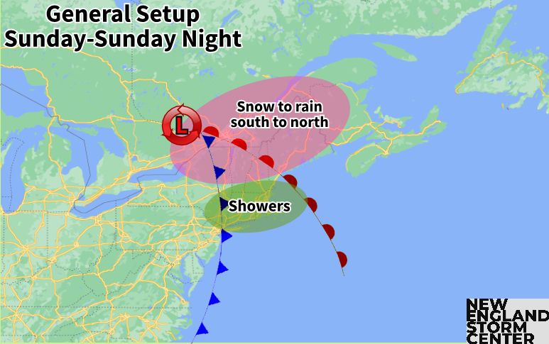
The coastal front has generally struggled to push inland across northern New England. While the rain/snow will continue to wobble west a bit, it likely won't push too much further inland over the next few hours #MAwx #CTwx #RIwx #NHwx #VTwx

02.12.2025 18:49 β€” πŸ‘ 4    πŸ” 1    πŸ’¬ 0    πŸ“Œ 0
Post image Post image Post image Post image

Not much change in overall thinking this morning. The biggest area of uncertainty in total snowfall remains the coastal plain from about Gloucester through Portland. The jackpot zone looks to set up across central New Hampshire and southern Vermont. #MAwx #CTwx #RIwx #NHwx #MEwx #VTwx

02.12.2025 13:16 β€” πŸ‘ 4    πŸ” 0    πŸ’¬ 0    πŸ“Œ 2
Post image Post image Post image Post image

Only minor adjustments to our snowfall map from this morning, mainly to shift snow totals a bit farther north/west. Mild air off the ocean & a quick-hitting storm will help keep snowfall in check for many. Still expect a band of 6-10+" across central New England. #MAwx #CTwx #RIwx #NHwx #MEwx #VTwx

01.12.2025 22:23 β€” πŸ‘ 8    πŸ” 0    πŸ’¬ 0    πŸ“Œ 0
Post image

The biggest question that remains with this storm will be how far inland the rain/snow line can push. This is especially true for the North Shore, NH Seacoast and southwest Maine. Not the drop in likelihood of 6" of snow from inland to the coast. #MAwx #NHwx #MEwx

01.12.2025 14:37 β€” πŸ‘ 5    πŸ” 1    πŸ’¬ 0    πŸ“Œ 0
Preview
Thump of Snow Incoming to New England: Impacts, Timing A deepening low pressure will likely be pulling out of the Mid-Atlantic and pushing northeast toward New England early next week. The overall setup and position of this system will favor cyclogenesis,...

A thump of snow is incoming to a large portion of New England tomorrow. While not an overly intense storm, it will bring a widespread 4-8 inches and kick off meteorological winter with a bit of a bang. Details: #MAwx #CTwx #RIwx #NHwx #MEwx #VTwx
www.newenglandstormcenter.com/post/thump-o...

01.12.2025 12:46 β€” πŸ‘ 8    πŸ” 2    πŸ’¬ 0    πŸ“Œ 0
Post image Post image Post image Post image

This continues to look like a wide 4-8" jackpot zone type storm. A narrow mesoscale band will likely set up within the jackpot zone, leading to some higher amounts. How close the higher snowfall makes it to the coast remains the biggest question. #MAwx #CTwx #RIwx #NHwx #MEwx #VTwx

30.11.2025 23:48 β€” πŸ‘ 10    πŸ” 1    πŸ’¬ 0    πŸ“Œ 0
Preview
Snowstorm Incoming to New England on Tuesday A deepening low pressure will likely be pulling out of the Mid-Atlantic and pushing northeast toward New England early next week. The overall setup and position of this system will favor cyclogenesis,...

A nor'easter is poised to bring southern and central New England their first widespread wintry weather of the season this upcoming Tuesday. Details here: #MAwx #CTwx #RIwx #NHwx #MEwx #VTwx
www.newenglandstormcenter.com/post/snowsto...

30.11.2025 15:51 β€” πŸ‘ 4    πŸ” 0    πŸ’¬ 0    πŸ“Œ 1
Post image Post image Post image

Tuesday's storm will be all about the track.This will determine where a rain/snow line sets up.There may be a sharp cutoff in the highest snow, which will occur just north of where the storm stays all snow. Recent trends have pointed to an earlier arrival as well. #MAwx #CTwx #RIwx #NHwx #MEwx #VTwx

29.11.2025 22:40 β€” πŸ‘ 6    πŸ” 0    πŸ’¬ 1    πŸ“Œ 0
Post image Post image

Not much change for the quick-hitting storm tomorrow. This storm brought a decent snowstorm to parts of the Midwest, but it will rise north of New England, leading to a milder storm. It'll still be cold enough for a couple inches across the north. #MAwx #NHwx #MEwx #VTwx #CTwx

29.11.2025 21:41 β€” πŸ‘ 1    πŸ” 0    πŸ’¬ 0    πŸ“Œ 0
Post image Post image

An impressive lake-effect snow band yesterday stretched into western Massachusetts, bringing several inches of snow. Upslope snow also brought Vermont's northern mountains a fresh coating yesterday. #MAwx #VTwx #NHwx #MEwx

29.11.2025 15:16 β€” πŸ‘ 3    πŸ” 2    πŸ’¬ 0    πŸ“Œ 0
Preview
Latest Trends on Incoming Storms for New England New England's next system will arrive later Sunday and into Monday. This system will take an interior storm track. This would result in another setup with a warm front lifting northward, resulting in ...

A couple storms are incoming to New England, the first will be weak and low-impact. The second early next week is shaping up to be more wintry and impactful. Here are the latest trends: #MAwx #CTwx #RIwx #NHwx #MEwx #VTwx
www.newenglandstormcenter.com/post/latest-...

29.11.2025 13:32 β€” πŸ‘ 3    πŸ” 0    πŸ’¬ 0    πŸ“Œ 0
Post image Post image Post image Post image

Update on New England's 2 incoming storms.Sunday remains on track as a quick hitter w/ minor snow in the north country.Tuesday will come down to how close the track is to the coast, but this will be a stronger storm with more snow (several inches in jackpot zone). #MAwx #CTwx #RIwx #NHwx #MEwx #VTwx

28.11.2025 23:14 β€” πŸ‘ 7    πŸ” 4    πŸ’¬ 0    πŸ“Œ 0
Preview
New England Stays Unsettled with Systems Incoming Sunday and Tuesday New England will be staying generally unsettled over the coming week as troughing once again dominates the region. The first chance for snow showers will come throughout the day today. A broad upper-l...

Troughing remains the name of the game for New England. After some snow showers today, more organized systems will push through New England Sunday and Tuesday or Tuesday night. Details: #MAwx #CTwx #RIwx #NHwx #MEwx #VTwx
www.newenglandstormcenter.com/post/new-eng...

28.11.2025 13:10 β€” πŸ‘ 3    πŸ” 2    πŸ’¬ 0    πŸ“Œ 0

Inland runners have dominated the past two winters, especially in December. Last winter, most coastal storms got suppressed outside the benchmark.

28.11.2025 11:58 β€” πŸ‘ 0    πŸ” 0    πŸ’¬ 1    πŸ“Œ 0
Post image Post image Post image Post image

A couple more storms on the way for New England.Next is an inside runner Sun to Mon, bringing rain south & snow/mix to rain across interior northern areas.More widespread wintry weather is possible Tuesday to Wednesday.Cold will be persistent to kick off December. #MAwx #CTwx #RIwx #NHwx #MEwx #VTwx

27.11.2025 23:57 β€” πŸ‘ 4    πŸ” 0    πŸ’¬ 1    πŸ“Œ 0
Preview
Uncovering New England's Prehistoric Hurricane Activity (Part 1 of 3) We have a passion for documenting and preserving as much weather history as we can here at New England Storm Center. As part of this, we have taken a dive into the world of paleo-tempest-ology to get ...

We have taken a dive into the world of paleotempestology to get a sense of potential storm activity before history was documented in New England. Here's the 1st of 3 studies we'll look into.This one focuses on Salt Pond in Falmouth, MA. #MAwx #CTwx #RIwx
www.newenglandstormcenter.com/post/uncover...

27.11.2025 21:14 β€” πŸ‘ 1    πŸ” 0    πŸ’¬ 0    πŸ“Œ 0
Post image Post image Post image Post image

After a mainly dry, albeit chilly & blustery Thanksgiving, New England will stay generally active. Upslope snows likely on Friday. A mix/rain event is on tap for Sunday into Monday. Another, potentially colder system may arrive around midweek. #MAwx #CTwx #RIwx #NHwx #MEwx #VTwx

27.11.2025 00:20 β€” πŸ‘ 6    πŸ” 0    πŸ’¬ 0    πŸ“Œ 0
Preview
Cooler, Breezy Weather Enters New England After Today; Unsettled Weather to Persist The leading edge of precipitation has now moved away from a vast majority of New England this morning. The upper-level low remains across the Great Lakes region, with the secondary low moving west and...

After a brief surge of warmth, cold weather will come to New England & stick around.Unsettled weather will also persist,with upslope activity on Fri & more systems to watch on Sun and around mid-week next week.Details: #MAwx #CTwx #RIwx #NHwx #MEwx #VTwx
www.newenglandstormcenter.com/post/cooler-...

26.11.2025 13:29 β€” πŸ‘ 4    πŸ” 0    πŸ’¬ 0    πŸ“Œ 0
Post image Post image Post image Post image

Temperatures will begin to warm tonight as a warm front lifts through New England. Warming will continue through Wed afternoon. Cold front moves through tomorrow night, sparking a sharp cool-down and blustery weather for Thanksgiving. #MAwx #CTwx #RIwx #NHwx #MEwx #VTwx

26.11.2025 00:05 β€” πŸ‘ 6    πŸ” 1    πŸ’¬ 0    πŸ“Œ 0

@nestormcenter is following 19 prominent accounts