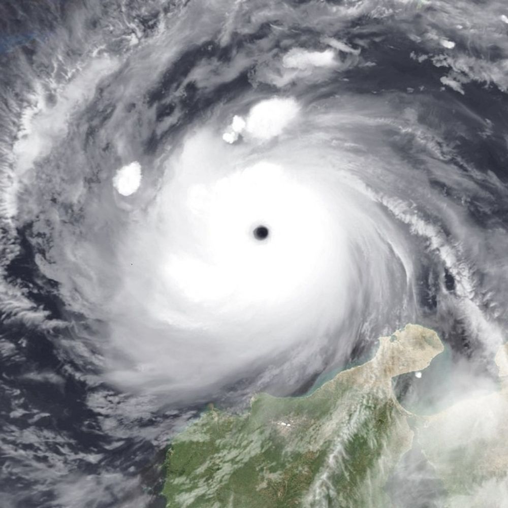
#Hurricane #Kiko is currently intensifying in the open Eastern Pacific. The current BT intensity is set at 90 kt and Kiko is expected to peak as a Category 3 in the coming days. Hawaii may want to watch out for downstream impacts in the coming week or two.
03.09.2025 01:53 — 👍 1 🔁 1 💬 0 📌 0


#erin appears to be strengthening as MW depicts half of a low level core. In addition, convection has blossomed post DMIN. SSTs are still a bit cool so I doubt Erin will strengthen a ton over the next day or so but Erin has potential to become a major #hurricane in a few days.
12.08.2025 00:14 — 👍 2 🔁 2 💬 0 📌 0
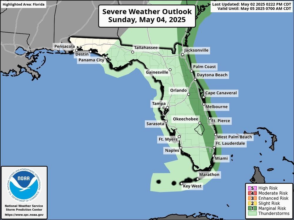
There is a Day 3 marginal risk for severe weather on Sunday for all of eastern Florida. A Front will come to provide come beneficial rains for the state. but along the way it is possible that a few strong storms can pop up. I Will have more on this tomorrow.
02.05.2025 22:12 — 👍 0 🔁 0 💬 0 📌 0


Fun subtropical depression attempt northeast of the Leeward Islands. No fronts are analyzed into the center.
02.05.2025 20:32 — 👍 9 🔁 1 💬 0 📌 0
I Will probably make a comeback to this platform soon. Stay on the lookout :)
28.04.2025 20:46 — 👍 0 🔁 0 💬 0 📌 0


Tropical Cyclone 04S has formed in the Southwest Indian ocean this afternoon with winds of 45 mph and a pressure of 1000 MB. it has become more organized over the past few hours and has become more aligned with it's MLC and LLC. some gradual strengthening is possible over the coming days.
09.12.2024 22:08 — 👍 1 🔁 0 💬 0 📌 0

Robyn has become a Category 1 Cyclone with winds of 75 MPH and a pressure down to 985 MPH. This is likely peak as Vertical Wind Shear starts to pick up tonight. #Cyclone #TropicalWeather #Weather
28.11.2024 19:09 — 👍 3 🔁 0 💬 0 📌 0

We now have Tropical Cyclone Robyn in the AUS region this morning. It currently has winds of 45 knots and a pressure of 994 MB. Some additional strengthen is possible the next day or so. #Weather #Cyclone #Tropics
28.11.2024 13:27 — 👍 2 🔁 0 💬 0 📌 0


GFS and Euro are showing the potential for a heavy Snowfall event for portions of New England in a few days. Some areas could pick up a foot of snow or so. #Weather #Snow
27.11.2024 23:13 — 👍 1 🔁 0 💬 0 📌 0

JTWC gives 03S a 45 knot peak. but personally i can see 50-55 knot peak. probably around their peak right now honestly. #Tropics #Cyclones #Weather
27.11.2024 14:06 — 👍 1 🔁 0 💬 0 📌 0
03S THREE 241127 1200 12.7S 91.2E SHEM 35 995
Looks like we have 03S according to JTWC. it has winds of 40 MPH and a pressure of 995 MB. Some slight additional Strength is possible, before conditions start to become less conducive.
27.11.2024 14:00 — 👍 1 🔁 0 💬 0 📌 0

There is an Tropical Cyclone Formation Alert out for Invest 96S this afternoon. ASCAT showed that it was pretty much a Tropical Storm at this point with about 35 knot winds. Since it's in the BoM AoR it won't get named until it has 75% of all quads with TS force winds, or unless it passes 90E
26.11.2024 21:18 — 👍 1 🔁 0 💬 0 📌 0

The signal for 96S/01U has been slowly increasing again over the last couple of days. I would expect anywhere from a broad slop, to a Tropical Storm, to a Category 1 Cyclone. At least for the time being. We will see if we get more than that when we start seeing it consolidate real time. #tropics
24.11.2024 12:23 — 👍 1 🔁 0 💬 0 📌 0


It is possible in the coming week that we could see Twin Tropical Cyclones in the NIO and the SWIO/AUS Regions. Where 01U ( 96S ) Has a medium chance of development. We will have to see how things plan out. But the latest model runs have been back and forth.
22.11.2024 02:59 — 👍 2 🔁 1 💬 0 📌 0
I finally find myself on blue sky. just like on twitter i will have Tropical Cyclone updates from official sources, as well as my own take on things. hope to enjoy the stay on the blue sky
22.11.2024 01:19 — 👍 3 🔁 0 💬 0 📌 0
Vivid Weather - Weather made simple.
https://discord.gg/fH24ruMbhj We have a community server with up to 600 members, all of which have an avid interest in tracking! Come join us!
International storm chaser documenting Tropical Cyclones, Hurricanes & Typhoons around the globe + Tornado Alley USA each spring 🌪
Darwin, Australia 🇦🇺
Drone Pilot/Photographer/Storm Chaser
https://youtube.com/@oreboundimages?si=B_RDa054TgcwTYdg
Meteorologist. Into weather records. Soft spot for subtropical 🌀. 😻 and nature imagery, too.
Welcome to the inner thoughts of a tired writer.
I'm a 20 year old lady originally from the US State of Minnesota, but now I reside in Montana. I have a lot on my mind and I don't usually have an outlet to share it, but that'll change right now.
Ask Pronouns | 🏳️🌈 | 🇨🇦 | Weather Enthusiast | Furry | 🌪️: 0
Weather 87 - Tropics, Weather, Updates + More
Co-Owner of Alan. Alex is the other.
Hi. Looking for a fresh start here, getting back to what I enjoy which is Music, Photography, and New Orleans. All pics are my own.
Average weather enthusiast -
Main areas of interest: Tropical Cyclones and (European) severewx
Weather, politics, and spaceflight fan
I also love women. 🔞🔞🔞MINORS AND OTHER STRANGE PEOPLE DNI!!
I am interested in weather (hurricanes & wildfires)
Scheduling nerd
NIMBY Rails superfan
Public Transit enthusiast + supporter
Weekend storm chaser, electrical engineer, and weather nerd.
https://youtube.com/@evanvaskewx?si=Xwzp4g_9pdVyHipH
Providing in-depth weather charts, statistics, and analysis. Stay informed about extreme weather events and global patterns. | Interested in Graphic Design 🌀
official Bluesky account (check username👆)
Bugs, feature requests, feedback: support@bsky.app