Cartogramme de Dorling représentant le nombre de mention de chaque pays dans les discours d'emmanuel macron entre 2017 et 2025 (bornes inclues). Dans l'ordre apparaissent en plus grand:
- La France énorme par rapport aux autres pays avec 11000 mentions,
- l'Ukraine et la russie avec près de 1000mentions
- la chine et les états unis avec le même nombre de mentions 896
- puis une 30 aine de pays entre 600 et 100 mentions,
- 89 entre 10 et 100
- et une soixantaine entre 1 et 10
Retour aux affaires 🗺️:
cartogramme de Dorling qui montre les pays les plus mentionnés dans les discours du président macron.
Version interactive et méthode : observablehq.com/@ocospace/do...
Donc #30DayMapChallenge 17: new tool car c'est github.com/riatelab/ber... qui a été le meilleur outil !
19.11.2025 12:12 — 👍 2 🔁 2 💬 1 📌 0

Le débroussaillement, principal levier de prévention des feux de forêt.
🔥 La résilience des forêts est notre responsabilité collective.
Les #OLD sont cruciales contre les incendies. Obligatoires près des massifs forestiers, ces travaux sont idéaux en automne/hiver pour créer une zone de sécurité et protéger la biodiversité.
ℹ️ www.ecologie.gouv.fr/feux-foret-v...
24.03.2025 09:29 — 👍 11 🔁 3 💬 0 📌 1
Mon royaume pour un tuto blender ! Le rendu est 🔥
07.02.2025 09:53 — 👍 0 🔁 0 💬 0 📌 0

Carte de la répartition des risques naturels en France hexagonale et Corse
❗ Feux de forêt, inondations, mouvements de terrain ou avalanche… Autant de menaces que le dérèglement climatique intensifie, rendant indispensable une planification adaptée pour connaitre et anticiper les risques.
🆕 Découvrez notre carte sur la répartition des risques sur la France hexagonale.
27.01.2025 14:56 — 👍 28 🔁 9 💬 2 📌 1
1 628 schools are exposed to more than 10 pesticides applications per year in France
04.12.2024 12:13 — 👍 11 🔁 10 💬 2 📌 0
😍
02.12.2024 14:38 — 👍 3 🔁 0 💬 0 📌 0

Noël sur data.gouv.fr - data.gouv.fr
Calendrier de l'avent de la données ouverte 2023
Pour ceux qui ont le blues post #30daymapchallenge, il y a le calendrier de l'avent @datagouvfr
www.data.gouv.fr/fr/pages/noel/
02.12.2024 11:04 — 👍 2 🔁 0 💬 0 📌 0
La réflexion sémio, la lisibilité de la légende et de la carte… 👌
01.12.2024 22:03 — 👍 3 🔁 0 💬 0 📌 0
Parce que les outre mer la tête à l’envers ça suffit 🙃
#30daymapchallenge - 26 - Projections
26.11.2024 08:06 — 👍 8 🔁 2 💬 0 📌 0
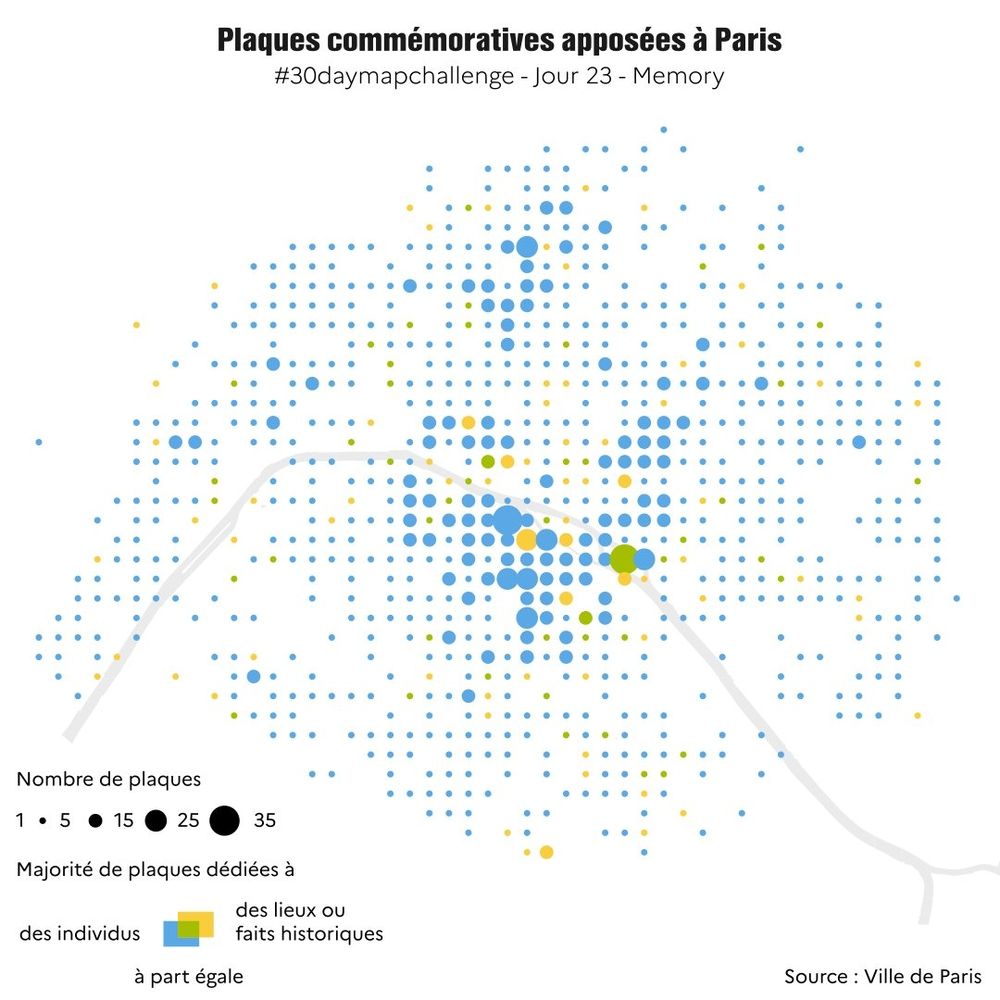
30DayMapChallenge J23 #MEMORY
Paris compte plus de 2500 plaques commémoratives rendant hommage à des lieux, des personnalités ou des épisodes de l'histoire. La carte ci-dessous en présente la répartition dans l'espace ainsi que la typologie.
✍️ @abigail2154.bsky.social
Source : Ville de Paris
23.11.2024 06:53 — 👍 11 🔁 4 💬 1 📌 0

A global grid map on a pale cream background. In the top-left, the title reads "Wikipedia Edit Wars' with a subtitle "Concentration of recent edits and reversions to the 'country page' of each nation". The main map shows each country as a grid square in approximately its geographic position shaded in a light colour according to continent. In each square is a text label giving the 2-letter country code and a circle sized by the rate of page revisions and coloured by the number of page reversions. A legend in the top-right reflects this with two rows of increasing circle size and colour from yellow to red. The largest circles in the main map tend also to be the most red with Zimbabwe being both the largest and darkest red. Other prominent countries include Portugal, India, Israel, Romania and Nicaragua.
#30DayMapChallenge Day 21: Conflict
Turned out to be more a day of data wrangling than map design. I scraped the edit history of country Wikipedia pages to look at 'edit wars'. Which pages are edited and reverted most often? Not, it appears, the obvious ones:
observablehq.com/@jwolondon/t...
21.11.2024 22:18 — 👍 31 🔁 4 💬 0 📌 0
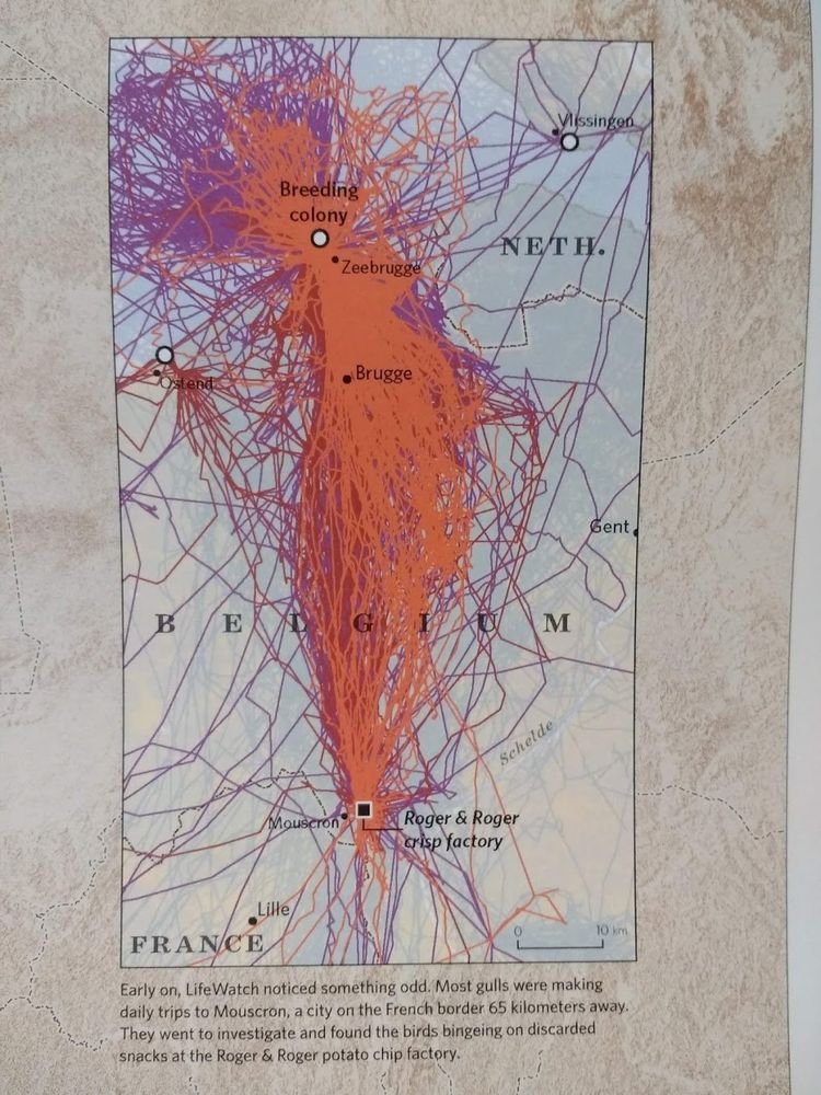
A map of flight paths emanating from breeding colony of gulls, with this caption: Early on, LifeWatch noticed something odd. Most gulls were making daily trips to Mouscron, a city on the French border 65 km away. They went to investigate and found the birds bingeing on discarded snacks at the Roger & Roger potato factory.
Today in relatable science: Gulls making a mysterious daily trip that turned out to be to a potato chip factory
15.11.2024 20:15 — 👍 16008 🔁 4316 💬 248 📌 446

30DayMapChallenge J16 #Choropleth - Des cartes à lire
📍Les cartes IGN sont couvertes d'annotations (noms de lieux, pts cotés, etc.) placées avec soin pour garantir leur lisibilité.
Cette #carte montre leur densité par emprise sur les cartes IGN au 1:50k
✍️ @abigail2154.bsky.social
from X @IGNFrance
16.11.2024 06:51 — 👍 14 🔁 3 💬 1 📌 0
L’Institut national de l'information géographique et forestière produit des données et représentations du territoire national pour observer, comprendre et anticiper ses évolutions. 🗺️🌳
🔗 https://kytelink.com/ign
#Opendata #Carte #Géographie #Forêt
French and main website: https://geotribu.fr
English blog: https://blog.geotribu.net/
#OSGeo #FOSS4G #opensource #GIS #GeoRDP #QChat
Data art since 2010, collecting data since I was 4yo. Poetic Web. Data and generative artist turning sound and music into visuals. Lecturer, TEDx speaker, tizianaalocci.com | London based | IG: tiz.alocci | Founder of dataviz studio https://necessity.ink/
Owner/Operator of North River Geographic Systems, Inc. Work with QGIS, PostGIS, GDAL and a host of other FOSS4G software. Located in the United States-> Tennessee […]
🌉 bridged from ⁂ https://fosstodon.org/@rjhale1971, follow @ap.brid.gy to interact
AAG brings together members of the global geographic community. We are an academic & professional organization representing educators, researchers, & practitioners in geography. https://www.aag.org/membership/
Seafloor mapper, Chief Scientist of smart mapping company Esri, Oregon State U. GIS/oceans professor, EC50, cyclist, 1st Black submersible diver to Challenger Deep, builds w/LEGO, raised in Hawaii. NAS, NAE, ORCID 0000-0002-2997-7611; She/her; views mine
Rien de particulier... beaucoup de musique classique et d'opéra... et un petit blog amateur...
#teamploumploum #teambaroque bref... team plein de choses!
Blog : erikcarnets.fr
Chef du service Contenus, médias et influence à l'IGN. Amateur de cartes, de science (ex-CNRS) et autres réjouissances
Small dataviz and shaded relief maps studio based in Italy, but working with the whole world.
🚀 vizart.io
✉️ hello@vizart.io
🕸️ Shop our maps at http://vizcart.io or http://vizcart.etsy.com
Cartographie | Géopolitique | Formations | Planisphères 🪐 |
Entreprise située au coeur du pays des mouettes et des crêpes 🌊
Je fais de la vulgarisation scientifique, des cartes et de la bande dessinée !
✏️🌍🖌️🗺️
Auteur de "Geographia" (Futuropolis / BnF).
Cartographie illustrée : jeanleveugle.fr
BD : www.lessavoirsambulants.fr
Insta : jeanleveugle
Independent health data visualization designer, speaker, and teacher | Data Viz Society Founding Board Member & Advisory Council, Exec Director 2021-2024
Journaliste-Cartographe @lemonde.fr
Concocte des cartes et des atlas chez Autrement, aux Arènes et chez Armand Colin
Ex compte Twitter : https://x.com/xemartinlaborde?s=21&t=TfSHTcYkiyL4elRNWbPcTw
Cartographe | Géomaticienne 🧭🌍
https://www.linkedin.com/in/c%C3%A9cile-matusiak-566545177/
Cartographer with a PhD in history, vintage cycling enthusiast, and problem vinyl hoarder in Durham, UK. landscapearchive.com
Data visualization designer & data scientist
Co-founder of Jetpack.AI
📍 Map design at Mapbox
📍 Maps of Madison WI + beyond via latlong.shop 🗺️🏳️🌈
geography, GIS, data visualization, people and the environment, inventing a liveable future, pedagogy and tech, cats, geeky stuff
Data designer, auteur du «Manuel de Datavisualisation» (Dunod)