Whoever is running audio for the hockey games on ESPN is doing a terrible job.
24.04.2025 01:12 — 👍 2 🔁 0 💬 0 📌 0

Taken on Monday at 5:37pm. That is an ANGRY sky.
21.04.2025 21:39 — 👍 2 🔁 0 💬 1 📌 0

TORNADO WARNING for areas in the red polygon until 6pm. Seek shelter in a basement or the lowest level of your home. These storms will develop quickly.
21.04.2025 21:35 — 👍 1 🔁 0 💬 0 📌 0

Winter Storm Warnings are in place for everyone in pink. From Windsor to Quebec and beyond, this is a massive storm system swinging through.
I’m tracking all of this on 680 NewsRadio Toronto!
16.02.2025 13:28 — 👍 2 🔁 0 💬 0 📌 0
E-L-G-L-E-S!
09.02.2025 23:21 — 👍 0 🔁 0 💬 0 📌 0
So when does Jake Moody get cut? At halftime?
31.12.2024 02:34 — 👍 0 🔁 0 💬 0 📌 0


10:26AM UPDATE: Really cold still across the #GTA but at least the winds are lighter today. Our Guaranteed High is -9°.
22.12.2024 15:26 — 👍 1 🔁 0 💬 0 📌 0


7:07AM UPDATE: Wow, look at those impressive wind chill values across areas that are under an Extreme Cold Warning right now including Barrie, Ajax, Whitchurch-Stouffville, Georgina, and Keswick.
#ONwx
22.12.2024 12:07 — 👍 1 🔁 0 💬 0 📌 0

7:25AM UPDATE: A look at those brutal wind chill values around #Toronto and parts of the province this morning!
Layer up and stay warm!
21.12.2024 12:25 — 👍 1 🔁 0 💬 1 📌 0
This #TNF game is so boring.
13.12.2024 03:57 — 👍 1 🔁 0 💬 0 📌 0

Can confirm (from my own personal shoveling experience) that we did get nearly 3 feet of snow in the Buffalo Southtowns.
Definitely the nastiest storm of the season so far but this should start to at least cool the lake down a bit more.
13.12.2024 01:38 — 👍 1 🔁 0 💬 0 📌 0

These are some of the latest amounts from the National Weather Service in Buffalo as of 11:30 a.m. this morning on how much snow has fallen.
Expecting another update in a little bit but this band has been headed right to the Buffalo Southtowns.
12.12.2024 19:13 — 👍 0 🔁 0 💬 0 📌 0

7:25AM UPDATE: This substantial band of lake effect is definitely intense. Just over 11 miles wide and it is targeting Hamburg, Angola, Orchard Park, East Aurora, and Eden.
More to come throughout the day.
12.12.2024 12:25 — 👍 0 🔁 0 💬 0 📌 0
Having Biscoff cookies when you're not on a Delta flight feels very odd.
10.12.2024 21:02 — 👍 0 🔁 0 💬 0 📌 0

LAKE EFFECT SNOW WARNINGS: Issued for Chautauqua, Southern Erie, Wyoming and Cattaraugus Counties from 4pm Wednesday to 1pm Friday.
For Northern Erie and Genesee Counties from 10pm Wednesday until 1pm Friday.
Significant snow along with strong winds will be the key impacts.
10.12.2024 17:46 — 👍 0 🔁 0 💬 0 📌 0

HEADS UP: Lake effect snow is back on Thursday for Western New York. Winter Storm Watches are posted for Wednesday to Friday evening.
09.12.2024 19:40 — 👍 0 🔁 0 💬 0 📌 0
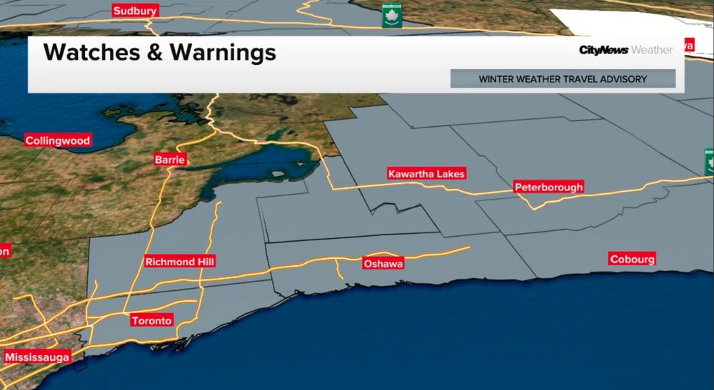
NEW: A Winter Weather Travel Advisory has been issued for Toronto, Markham, Oshawa, Ajax, and Uxbridge with snow and wind making for some potentially difficult travel this afternoon into the evening.
I'm tracking this for you on 680 NewsRadio! You can listen live at toronto.citynews.ca/listenlive
07.12.2024 11:08 — 👍 1 🔁 0 💬 0 📌 0
I can throw some in there and seal it off in a bottle!
05.12.2024 14:35 — 👍 0 🔁 0 💬 0 📌 0

11:13PM UPDATE: It will be a slow drive home from Orchard Park tonight with some pretty steady snow and breezy winds through the Southtowns and westbound travel on the 90 to areas south.
02.12.2024 04:13 — 👍 3 🔁 1 💬 0 📌 0
I think it’s hilarious hearing Cris Collinsworth talk about the weather on #SNF.
02.12.2024 02:35 — 👍 0 🔁 0 💬 0 📌 0

9:29PM UPDATE: Very little change in where this band is. It has been hovering over Blasdell, Lackawanna, Angola, and West Seneca.
It will finally make a move tomorrow further south.
01.12.2024 02:29 — 👍 1 🔁 0 💬 1 📌 0

Snowfall totals from Saturday afternoon from the National Weather Service’s Buffalo Office.
#LakeEffect #Buffalo #NYwx
30.11.2024 21:22 — 👍 0 🔁 0 💬 0 📌 0


Still dealing with closures of I-90 as of 9:25 a.m. Saturday morning.
In New York, I-90 Westbound is closed from Exit 57 to the PA State Line. Eastbound lanes are open, according to the NYS Thruway Authority.
In Pennsylvania, I-90 is closed in both directions from the PA State Line to I-79.
30.11.2024 14:25 — 👍 0 🔁 0 💬 0 📌 0

What a beautiful view of #Pittsburgh this morning!
It'll be a cold one but I'll have the details on a pretty decent weekend forecast on KDKA-TV from 5 to 8 a.m. and from 10 to 11 a.m.!
#PAwx
30.11.2024 09:31 — 👍 4 🔁 0 💬 0 📌 0

6:01PM UDPATE: We're definitely settling into cooler temperatures around Pittsburgh. Much colder now than it was yesterday at this time.
Colder air is sticking around this time!
29.11.2024 23:01 — 👍 0 🔁 0 💬 0 📌 0


4:20PM UPDATE: Here are two views of the 90 at Dunkirk (Exit 59) and Ripley (Exit 61). Miserable conditions and that snow is locked in over the Thruway at this point. Conditions likely to continue getting worse.
#BUFwx #LakeEffect
29.11.2024 21:20 — 👍 0 🔁 0 💬 0 📌 0

2:50PM UPDATE: The lake effect band has jogged a *little* further north. Still hugging the lakeshore with some intense snow primarily around Dunkirk and Silver Creek.
29.11.2024 19:50 — 👍 1 🔁 1 💬 0 📌 0

8:15AM UPDATE: Lake effect band squarely into Chautauqua and Cattaraugus Counties. Expecting 1-2” per hour snowfall rates and some gusty winds making travel difficult.
Band will stay here through most of the day.
29.11.2024 13:15 — 👍 2 🔁 0 💬 0 📌 0

JUST IN: A Lake Effect Snow Warning (in teal) has been issued for Southern Erie, Wyoming, Chautauqua, and Cattaraugus Counties from 7am Friday to 7pm Monday.
This is going to be particularly concentrated for the Chautauqua Ridge and along the 90 into Erie, Pennsylvania and parts of Northeast Ohio.
27.11.2024 17:28 — 👍 0 🔁 0 💬 0 📌 0
Taking steps now to prepare for 2025 and it feels fantastic.
27.11.2024 00:53 — 👍 0 🔁 0 💬 0 📌 0
Anchor and Correspondent, Bloomberg News | dgura2@bloomberg.net | Opinions are my own.
Covers the justice department for NPR
@npr.org correspondent reporting on how elections, the census, the Postal Service and other parts of the U.S. government work • signal: hansi.01 • email: hwang@npr.org • newsletter: hansilowang.com/stay-in-touch
NPR correspondent. 10 years in China and Taiwan. Now DC-based. My book "Let Only Red Flowers Bloom" is now out: https://www.penguinrandomhouse.com/books/724947/let-only-red-flowers-bloom-by-emily-feng/
Senior legal affairs reporter at POLITICO with a focus on democracy, the balance of power and the clash between the Trump administration and courts.
Since 1889 🗞️
Sign up for our newsletters and alerts: http://wsj.com/newsletters
Got a tip? http://wsj.com/tips
Follow our staff: https://go.bsky.app/2ppWqxF
Chief White House Correspondent for The New York Times and MS NOW analyst. Proud husband of @sbg1.bsky.social and equally proud father of @tab-delete.bsky.social. Co-author of "The Divider: Trump in the White House, 2017-2021."
NPR media guy
Author, Murdoch’s World
Chief economics correspondent at The Wall Street Journal
@NYTimes Columnist/Editor & @SquawkCNBC Co-Anchor. Author, Too Big To Fail. Founder, @DealBook. Co-Creator, BILLIONS @Showtime.
News updates from around the 🌎, all day, every day.
comedy and also normal stuff
comedy writer / songwriter / Twitter expat
/ video / info / resources /
Last Week Tonight with John Oliver
~ unaffiliated
Dad. Husband. Reporter at 9NEWS in Denver.
9NEWS Consumer Investigator - Steve On Your Side - Denver
Dad, husband, hockey fan, homebrewer
Reporter With 9News KUSA Denver.
Morning news anchor on 680 News Radio Toronto
https://toronto.citynews.ca/audio/
Part-time PA Announcer for the Toronto Sceptres
https://www.thepwhl.com/en/teams/toronto-sceptres
National Digital Broadcast Journalist
Global News
I picked a hell of a time to be a business reporter!
Posts and opinions are my own
IG: Ari_Rabin
Swiss army knife at Sportsnet 590 The FAN 📻