Yellowstone Earthquake Update
February 12 – 25, 2026
31 earthquakes have been located in the Yellowstone Region over the past two weeks. The largest was an M 2.4 located north of the East Entrance to Yellowstone National Park.

Map of seismicity in Yellowstone. Over this time period (February 12 – 25, 2026) 31 earthquakes have been located in the Yellowstone Region. The magnitudes ranged M -0.1 – 2.4.

The largest earthquake in the region was an M 2.4 on February 24, located about 12 miles north of Pahaska Tepee, WY.

Magnitude vs. Time plot for Earthquakes in the Yellowstone Region, February 12 – 25, 2026
Yellowstone Earthquake Update
February 12 – 25, 2026
31 earthquakes have been located in the Yellowstone Region over the past two weeks. The largest was an M 2.4 located north of the East Entrance to Yellowstone National Park.
26.02.2026 23:37 —
👍 0
🔁 0
💬 0
📌 0

Over the last two weeks, 64 earthquakes have been located in the Utah Region. The magnitudes ranged M 0.0 to 3.5. Two M 3.5's were located. The first on Feb. 5, was located between Lehi and Saratoga Springs, UT. The second on Feb 13, was located in West Valley City. Both of these quakes were widely felt along the Wasatch Front.

Over the last two weeks (February 5 – 18, 2026) 64 earthquakes have been located in the Utah Region. The magnitudes ranged M 0.0 to 3.5.

Tied for the largest earthquake in the reporting period was an M 3.5 on February 13, located in West Valley City, UT. This earthquake includes more than 4,100 felt reports on the USGS "Did You Feel It" webpage.
Tied for the largest earthquake in the reporting period was an M 3.5 on February 5, located about 4 miles north of Saratoga Springs, UT. This earthquake includes more than 2,880 felt reports on the USGS"Did You Feel It" webpage.

Magnitude vs. Time Plot for the Utah Region, February 5 – 18, 2026
Over the last two weeks, 64 earthquakes have been located in the Utah Region. Magnitudes ranged M 0.0 to 3.5. Two M 3.5's were located:
1) Feb. 5, located between Lehi and Saratoga Springs, UT.
2) Feb 13, located in West Valley City. Both were widely felt along the Wasatch Front.
19.02.2026 22:51 —
👍 0
🔁 0
💬 0
📌 0
Aftershocks can have their own aftershocks, and it is not uncommon for aftershock sequences to last for years! Aftershocks typically decrease in magnitude and number with time, so this larger one is a bit of an outlier, but not unheard of or alarming.
17.02.2026 20:08 —
👍 2
🔁 0
💬 0
📌 0

Friday’s M3.5 and its 13 aftershocks overlap with the aftershock region of the 2020 M5.7 Magna earthquake and is likely an aftershock of the 2020 event. Seismicity in the Magna area is still elevated relative to pre-2020 levels, indicating that aftershocks are still continuing.
17.02.2026 20:08 —
👍 3
🔁 2
💬 1
📌 0

Yellowstone Earthquake Update
01.29.26 – 02.11.26
44 earthquakes have been located in the Yellowstone Region over the past two weeks. The largest was an M 2.2 located north of West Yellowstone, MT. A small swarm of 12 earthquakes was located north of West Yellowstone, MT.

Over this time period (January 29 – February 11, 2026) 44 earthquakes have been located in the Yellowstone Region. The magnitudes ranged M 0.2 – 2.2.

A swarm of 12 small earthquakes on February 7 – 8 as located about 6 miles north of West Yellowstone, MT.
The magnitudes ranged from M 0.2 – 2.2. The swarm includes the largest earthquake for this reporting period, an M 2.2 on February 7.

Magnitude vs. Time plot for Earthquakes in the Yellowstone Region, January 29 – February, 11.
Yellowstone Earthquake Update
01.29.26 – 02.11.26
44 earthquakes have been located in the Yellowstone Region over the past two weeks. The largest was an M 2.2 located north of West Yellowstone, MT.
A small swarm of 12 earthquakes was located north of West Yellowstone, MT.
12.02.2026 19:22 —
👍 0
🔁 0
💬 0
📌 0

Utah Earthquake Update
01.22.26 – 02.04.26
Over the last two weeks, 100 earthquakes have been located in the Utah Region. The magnitudes ranged M -0.3 to 4.7. The largest was an M 4.7 on January 22, south of Evanston, WY on the north slope of the Uinta Mountains. The earthquake was widely felt across northern Utah.

Over the last two weeks (Jan. 22 – Feb. 4, 2026) 100 earthquakes have been located in the Utah Region. The magnitudes ranged M -0.3 to 4.7.

Bear River Area Earthquakes N = 21 Magnitude Range 0.9 – 4.7

Magnitude vs. Time plot of Earthquakes in the Utah Region, January 22 – February 4, 2026.
Utah Earthquake Update
From 01.22.26 – 02.04.26, 100 quakes have been located in the Utah Region. Mags ranged M -0.3 to 4.7. The largest was an M 4.7 on Jan. 22, south of Evanston, WY on the north slope of the Uinta Mountains. The quake was widely felt across northern Utah.
05.02.2026 19:14 —
👍 1
🔁 0
💬 0
📌 0

Magnitude vs. Time plot for Earthquakes in the Yellowstone Region, January 15 – 28, 2026
29.01.2026 18:36 —
👍 0
🔁 0
💬 0
📌 0

Yellowstone Earthquake Update
01.15.26 – 01.28.26
49 earthquakes have been located in the Yellowstone Region over the past two weeks. The largest was an M 2.5 located northeast of Lake, YNP. A small swarm of 14 earthquakes was located northeast of Old Faithful.

Over this time period (January 15 – 28, 2026) 49 earthquakes have been located in the Yellowstone Region. The magnitudes ranged M -0.2 – 2.5.

The largest earthquake in the region was an M 2.5 on January 16, located about 8 miles northeast of Lake, YNP.

A swarm of 14 small earthquakes on January 26 was located about 12 miles northeast of Old Faithful, YNP. The magnitudes ranged from M 0.0 — 2.1.
Yellowstone Earthquake Update
01.15.26 – 01.28.26
49 earthquakes have been located in the Yellowstone Region over the past two weeks. The largest was an M 2.5 located northeast of Lake, YNP. A small swarm of 14 earthquakes was located northeast of Old Faithful.
29.01.2026 18:36 —
👍 0
🔁 0
💬 1
📌 0

A map update from the Bear River earthquake this morning. We have located a total of 15 earthquakes as of 4 PM MST with magnitudes from 1.1 - 4.7. Our UUSS team of network engineers installed 2 temporary seismometers nearby in the first 8 hours to monitor aftershocks.

24-hour helicorder from station LHUT showing the M2.4 Foreshock, M4.7 Mainshock, and the M3.0 aftershock.

Network engineer installing one of two temporary stations in the region of this morning's earthquake.
An update from the Bear River earthquake this morning. We have located a total of 15 earthquakes as of 4 PM MST with magnitudes from 1.1 - 4.7.
Our UUSS team of network engineers installed 2 temporary seismometers nearby in the first 8 hours to monitor aftershocks.
23.01.2026 00:00 —
👍 2
🔁 0
💬 0
📌 0

Utah Earthquake Update
01.08.26 – 01.21.26
Over the last two weeks, 29 earthquakes have been located in the Utah Region. The magnitudes ranged M 0.2 to 2.5. The largest was an M 2.2 on January 10, southwest of Colorado City, AZ.

Over the last two weeks (January 8 – 21, 2026) 29 earthquakes have been located in the Utah Region. The magnitudes ranged M 0.2 to 2.5.

The largest earthquake in the reporting period was an M 2.5 on January 10, located about 7 miles southwest of Colorado City, AZ.

Magnitude vs. Time plot for the Utah Region, January 8 – 21, 2026.
Utah Earthquake Update
01.08.26 – 01.21.26
Over the last two weeks, 29 earthquakes have been located in the Utah Region. The magnitudes ranged M 0.2 to 2.5. The largest was an M 2.2 on January 10, southwest of Colorado City, AZ.
22.01.2026 20:16 —
👍 0
🔁 0
💬 0
📌 0
YouTube video by University of Utah Seismograph Stations
M4.7 Earthquake in Northeastern Utah: Press Conference with UUSS Director Dr. Keith Koper
UUSS Director, Dr. Keith Koper, spoke with local news outlets this morning about the M4.7 earthquake. Watch it here:
youtu.be/I9LqjedQp5I
22.01.2026 18:47 —
👍 0
🔁 0
💬 0
📌 0

43 earthquakes have been located in the Yellowstone Region over the past two weeks. The largest was an M 2.6 located west of Hebgen Lake, MT.

Over this time period (January 1 – 14, 2026) 43 earthquakes have been located in the Yellowstone Region. The magnitudes ranged M -0.3 – 2.6.

The largest earthquake in the region was an M 2.6 on January 10, located about 3 miles west of Hebgen Lake, MT.

Magnitude versus Time plot for Earthquakes in the Yellowstone Region, January 1 – 14, 2026.
Yellowstone Earthquake Update (January 1 – 14, 2026) 43 earthquakes have been located in the Yellowstone Region. The magnitudes ranged M -0.3 – 2.6. The largest earthquake in the region was an M 2.6 on January 10, located about 3 miles west of Hebgen Lake, MT.
15.01.2026 17:55 —
👍 0
🔁 0
💬 0
📌 0

Text:
Utah Earthquake Update 12.25.25 – 01.07.26
Over the last two weeks, 64 earthquakes have been located in the Utah Region. The magnitudes ranged M 0.1 to 3.3. The largest was an M 3.3 on January 4, east of Huntsville, UT.

Over the last two weeks (Dec. 25 – Jan. 7, 2025) 64 earthquakes have been located in the Utah Region. The magnitudes ranged M 0.1 to 3.3.

The largest earthquake in the reporting period was an M 3.3 on January 4, located about 9 miles east of Huntsville, UT.

Magnitude vs. Time plot for the Utah Region, December 25, 2025 – January 7, 2026.
Over the last two weeks, 64 earthquakes have been located in the Utah Region. The magnitudes ranged M 0.1 to 3.3. The largest was an M 3.3 on January 4, east of Huntsville, UT.
08.01.2026 18:19 —
👍 0
🔁 0
💬 0
📌 0

Over the last two weeks, 87 earthquakes have been located in the Utah Region. The magnitudes ranged M -0.1 to 2.3. The largest was an M 2.3 on December 11, southeast of Manti, UT.

Over the last two weeks (December 11 – 24, 2025) 87 earthquakes have been located in the Utah Region. The magnitudes ranged M 0.2 to 2.3.

The largest earthquake in the reporting period was an M 2.3 on December 11, located about 14 miles southeast of Manti, UT.

Magnitude vs Time plot for Utah earthquakes for December 11 – 24, 2025.
Over the last two weeks, 87 earthquakes have been located in the Utah Region. The magnitudes ranged M -0.1 to 2.3. The largest was an M 2.3 on December 11, southeast of Manti, UT.
06.01.2026 22:10 —
👍 0
🔁 0
💬 0
📌 0

45 earthquakes have been located in the Yellowstone Region over the past two weeks. The largest was an M 2.7 located south-southeast, YNP.

Over the last two weeks (December 18 – 31, 2025) 45 earthquakes have been located in the Yellowstone Region. The magnitudes ranged M -0.1 – 2.7.

The largest earthquake in the region was an M 2.7 on December 31, located about 6 miles sout-southeast of Norris Junction, YNP.

Magnitude vs Time plot for Yellowstone earthquakes for December 18 – 31, 2025.
Over this time period (December 18 – 31, 2025) 45 earthquakes have been located in the Yellowstone Region. The magnitudes ranged M -0.1 – 2.7.
The largest earthquake in the region was an M 2.7 on December 31, located about 6 miles south-southeast of Norris Junction, YNP.
06.01.2026 22:04 —
👍 0
🔁 0
💬 0
📌 0

25 earthquakes have been located in the Yellowstone Region over the past two weeks. The largest was an M 2.1 located north-northeast of Moran, WY.

Over the last two weeks (December 4 – 17, 2025) 25 earthquakes have been located in the Yellowstone Region. The magnitudes ranged M 0.1 – 2.1

The largest earthquake in the region was an M 2.1 on December 17, located about 22 miles north-northeast of Moran, WY.

Magnitude vs Time plot for Yellowstone earthquakes for December 4 – 17, 2025.
Over the last two weeks (December 4 – 17, 2025) 25 earthquakes have been located in the Yellowstone Region. The magnitudes ranged M 0.1 – 2.1
18.12.2025 21:08 —
👍 1
🔁 0
💬 0
📌 0

Text in front of a photo of a mountain lake: Utah Earthquake Update 11.27.25 – 12.10.25: Over the last two weeks, 111 earthquakes have been located in the Utah Region. The magnitudes ranged M -0.1 to 3.0. The largest was an M 3.0 on December 8, northwest of Little America, WY.

Topographic map of Utah with earthquakes plotted as filled circles. Text: Over the last two weeks (Nov. 27 – Dec. 10, 2025), 111 earthquakes have been located in the Utah Region. The magnitudes ranged M -0.1 to 3.0.

Zoomed in topographic map showing a portion of southwest Wyoming with the text: The largest earthquake in the reporting period was an M 3.0 on December 8, located about 3 miles northwest of Little America, WY.

Magnitude vs Time plot for Utah Region Earthquakes, November 27 – December 10, 2025.
Utah Earthquake Update: Over the last two weeks, 111 earthquakes have been located in the Utah Region. The magnitudes ranged M -0.1 to 3.0. The largest was an M 3.0 on December 8, northwest of Little America, WY.
11.12.2025 17:09 —
👍 1
🔁 0
💬 0
📌 0

Magnitude vs Time plot for Yellowstone earthquakes Nov 20 - Dec 3
04.12.2025 21:36 —
👍 0
🔁 0
💬 0
📌 0

115 earthquakes have been located in the Yellowstone Region over the past two weeks. The largest was an M 2.0 located south-southwest of Mammoth, WY. This is near an ongoing swarm which added 28 quakes. An additional ongoing swarm northeast of Old Faithful includes 51 new earthquakes.

Over the last two weeks (Nov. 20 – Dec. 3, 2025) 115 earthquakes have been located in the Yellowstone Region. The magnitudes ranged M -0.1 – 2.0.
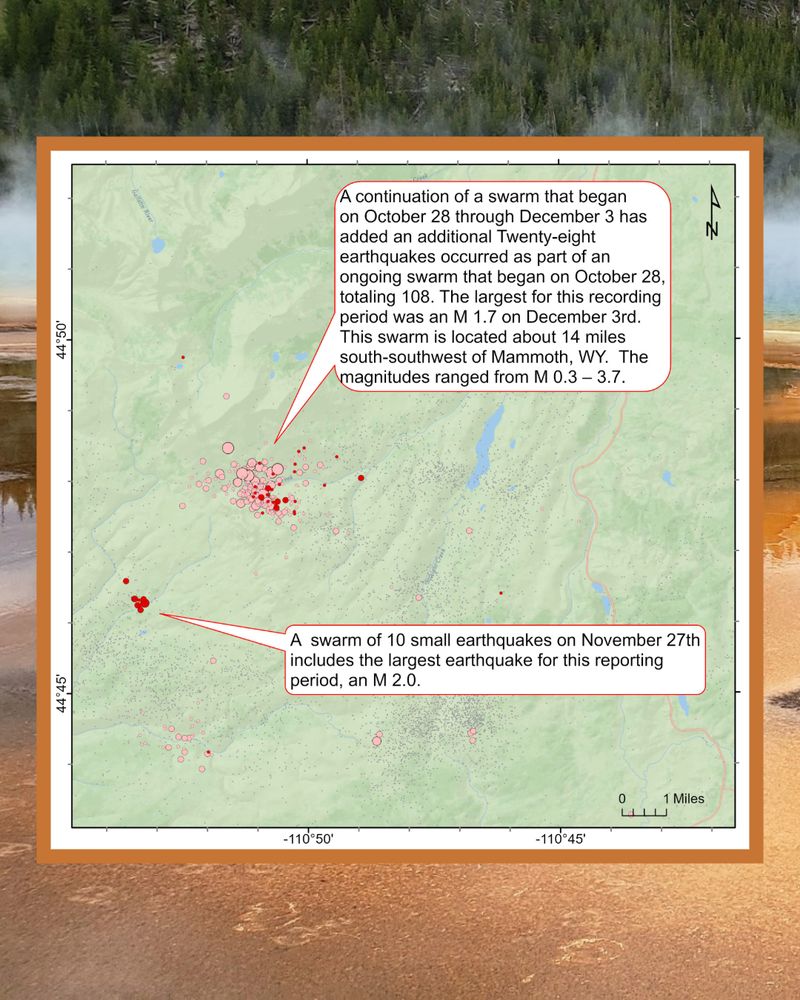
A continuation of a swarm that began on October 28 through December 3 has added an additional Twenty-eight earthquakes occurred as part of an ongoing swarm that began on October 28, totaling 108. The largest for this recording period was an M 1.7 on December 3rd. This swarm is located about 14 miles south-southwest of Mammoth, WY. The magnitudes ranged from M 0.3 – 3.7.

A continuation of a swarm that began on October 28 through December 3 has added an additional Twenty-eight earthquakes occurred as part of an ongoing swarm that began on October 28, totaling 108. The largest for this recording period was an M 1.7 on December 3rd. This swarm is located about 14 miles south-southwest of Mammoth, WY. The magnitudes ranged from M 0.3 – 3.7.
Yellowstone Earthquake Update: 115 earthquakes have been located in the Yellowstone Region over the past two weeks. The largest was an M 2.0 located south-southwest of Mammoth, WY. An additional ongoing swarm northeast of Old Faithful includes 51 new earthquakes.
04.12.2025 21:36 —
👍 1
🔁 0
💬 1
📌 0

Over the last two weeks, 131 earthquakes have been located in the Utah Region. The magnitudes ranged M -0.4 to 3.7. The largest was an M 3.7 on November 17, northwest of Little America, WY.

Over the last two weeks (November 13 – 26, 2025) 131 earthquakes have been located in the Utah Region. The magnitudes ranged M -0.4 to 3.7.

The largest earthquake in the reporting period was an M 3.7 on November 17, located about 3 miles northwest of Little America, WY.

Magnitude vs Time plot for Utah Region Earthquakes Nov 13 -26
Utah Earthquake Update: Over the last two weeks, 131 earthquakes have been located in the Utah Region. The magnitudes ranged M -0.4 to 3.7. The largest was an M 3.7 on November 17, northwest of Little America, WY.
04.12.2025 21:26 —
👍 1
🔁 0
💬 0
📌 0

The last @utahfootball.bsky.social home game is over and what a game it was! what an amazing comeback! It started with Tao Johnson's pick 2, Larry Simmons' TD grab, Devon Dampier's TD, and Lander Barton's interception! @utahathletics.bsky.social @utah.edu #UteQuake
26.11.2025 20:37 —
👍 2
🔁 3
💬 1
📌 0

Scatter plot titled "Earthquakes in the Yellowstone Region, November 6 – 19, 2025" with Date on x-axis and Magnitude on y-axis. Text: For more information about Yellowstone earthquakes, visit quake.utah.edu
20.11.2025 20:21 —
👍 0
🔁 0
💬 0
📌 0

The background image is of Grand Prismatic Spring in Yellowstone National Park.
Text:
Yellowstone Earthquake Update 11.06.25 – 11.19.25, 121 quakes have been located in the Yellowstone Region over the past two weeks. The largest was an M 3.2 located south-southwest of the Mammoth, WY. This is part of an ongoing swarm. A second swarm northeast of Old Faithful includes 49 quakes.

Map of Yellowstone seismicity. Text:
Over the last two weeks (November 6 – 19, 2025), 121 earthquakes have been located in the Yellowstone Region. The magnitudes ranged M -0.4 – 3.2.

Zoomed-in map of Yellowstone seismicity. Text: A continuation of a swarm that began on October 28 through November 13 has added an additional 28 earthquakes for a total of 80. This includes an M 3.2 on Nov. 9 and an M 3.1 on Nov. 8. The M 3.2 was the largest of the reporting period. This swarm is located about 14 miles south-southwest of Mammoth, WY. The magnitudes ranged from M 0.3 – 3.7.

Zoomed-in map of Yellowstone seismicity. Text:
An ongoing swarm of 49 earthquakes began on November 6. It is clustered about 15 miles northeast of Old Faithful,YNP. The magnitudes ranged M -0.4 – 2.1.
Yellowstone Earthquake Update 11.06.25 – 11.19.25, 121 quakes were located in the Yellowstone Region. The largest was an M 3.2 located south-southwest of the Mammoth, WY. This is part of an ongoing swarm. A second swarm northeast of Old Faithful includes 49 quakes.
20.11.2025 20:21 —
👍 0
🔁 0
💬 1
📌 0
Since 1981, the UUSS has located 67 M2 or greater events within 15 mi of this event's epicenter. The largest of these events was a magnitude 5.2, which occurred on February 3, 1995. (2/3)
18.11.2025 00:46 —
👍 1
🔁 0
💬 1
📌 0