Looks like Presidents Day is our next threat.
10.02.2026 04:31 — 👍 1 🔁 0 💬 0 📌 0

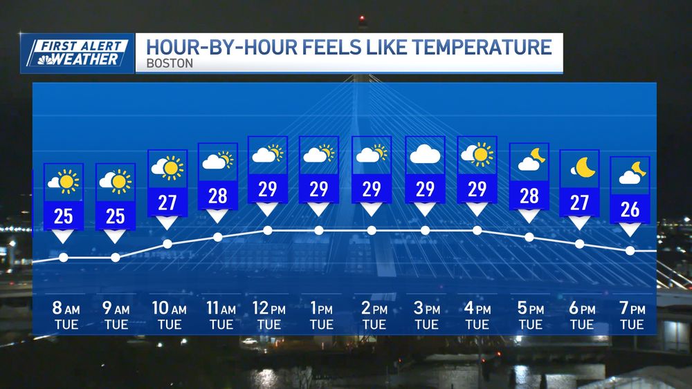
Oh look…more snow. This one doesn’t pull any punches, however. Starts 3-5p Tuesday, wraps after midnight. Not a problem for the AM commute Wednesday. (And no, the 4+ doesn’t mean you’ll get 8, 10, or 12”. More like 4.5 or 5”.)
10.02.2026 04:29 — 👍 8 🔁 1 💬 0 📌 1


Snow first (starts after midnight Saturday, ends in the afternoon) then the bitter cold. Winter lumbers on…our coldest in 22 years!
06.02.2026 03:39 — 👍 6 🔁 2 💬 1 📌 0

This is superb.
03.02.2026 21:38 — 👍 12 🔁 2 💬 0 📌 0
Yes! We are seeing that threat increase.
28.01.2026 15:31 — 👍 1 🔁 0 💬 1 📌 0
Blizzard of ‘22.
27.01.2026 13:41 — 👍 2 🔁 0 💬 0 📌 0
23.2” is the final tally from the storm in Boston. Took almost 4 years to nearly match the 23.6” in the blizzard of ‘23. This is Boston’s 8th highest snowfall on record for ANY month.
27.01.2026 07:32 — 👍 10 🔁 2 💬 1 📌 0
In the thick of it now. Heavy snow thru 9-10pm. Lighter tomorrow. Some spots already up to 10”!
25.01.2026 23:49 — 👍 4 🔁 0 💬 0 📌 0

Well here it is. Starts mid AM Sunday and wraps in Monday….maybe in the PM (some uncertainty there). Most intense part is late PM Sunday until 10-11pm.
22.01.2026 21:12 — 👍 6 🔁 0 💬 1 📌 1

Northern Lights possible tonight. We’ll battle the clouds, but the best viewing is toward morning. Point your phone’s camera at the faint glow in the sky to see it best.
19.01.2026 22:40 — 👍 9 🔁 2 💬 1 📌 0

Moderate to heavy snow on tap from the Seacoasf of NH to Greater Worcester in next 2-3 hrs. Some of this will be mixed with sleet at times. A solid 1-2”+ possible in those locations. Inside 495 it’s mostly rain & a little sleet.
17.01.2026 17:56 — 👍 4 🔁 0 💬 1 📌 0


We welcomed winter at 10:03 this morning. Now for some wintry weather Tuesday. Light snow moves in by noonish. Ends late Tue. night. Some mix with rain along immediate coast.
22.12.2025 02:39 — 👍 5 🔁 0 💬 0 📌 0


High winds through the early afternoon may cause outages or damage. Big ramp DOWN for the evening, then somewhat gusty overnight. Be safe!
19.12.2025 16:14 — 👍 4 🔁 0 💬 0 📌 0


The first 16 days of December were the coldest in 25 years in Boston. The tide turns through Friday where we rise near 60 in the wind & rain.
17.12.2025 14:51 — 👍 3 🔁 0 💬 1 📌 0
It will be!
08.12.2025 23:21 — 👍 1 🔁 0 💬 1 📌 0


Lenticular clouds above Mt. Washington today. Completely harmless, they form when stable air is forced to rise over a mountain range. Note the striking resemblance to “mothership” supercell thunderstorms - which can be precursors for tornadoes.
26.11.2025 01:44 — 👍 15 🔁 4 💬 2 📌 0

Logan Airport finally hit the magic mark. 1st 32 of the season this morning. Tough go this year. Came so close several times. Avg is Nov. 5th. Latest is Dec 6th in 2009.
20.11.2025 13:48 — 👍 5 🔁 0 💬 0 📌 0

1st accumulation of the season in Spencer, Mass tonight. Three days later than last year.
17.11.2025 03:06 — 👍 3 🔁 0 💬 0 📌 0
What we call a strong pressure gradient. Very deep low pressure formed near the Gaspe Peninsula north of Maine.
04.11.2025 03:46 — 👍 0 🔁 0 💬 0 📌 0


Tonight's storm over us will undergo bombogenesis by morning off Cape Breton Island, NS (pic 1). This means more wind Tue. If you're counting, that's two bombs in the Maritime provinces in less than a week...& another by Thu. Real cold pours in next week (pic 2)!
04.11.2025 03:45 — 👍 9 🔁 1 💬 0 📌 0

Double rainbow
Does this mean winter will be kind to us? Double rainbow over Needham this evening.
24.10.2025 22:44 — 👍 9 🔁 0 💬 0 📌 1
This is the heaviest it will be with this event. Lighter showers after noon, then some clearing by 3p. 🌧️
20.10.2025 15:07 — 👍 4 🔁 0 💬 0 📌 0
You are good. No worries. I rank this storm 4/5 out of 10 for Boston nor’easter standards.
13.10.2025 01:50 — 👍 1 🔁 0 💬 0 📌 0


Few unhappy customers with the rain through midday tomorrow. October air follows.
08.10.2025 02:47 — 👍 5 🔁 0 💬 0 📌 0
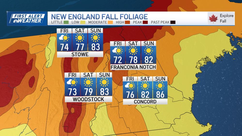

Foliage peaking in Northern New England this weekend! Toasty temps through Tuesday. Sea breezes knock us back a bit at the coast. ☀️
03.10.2025 03:51 — 👍 6 🔁 0 💬 0 📌 0


Mild weekend ahead. Slight risk of a shower early Sunday. Steady drop in temps next week.
26.09.2025 03:09 — 👍 2 🔁 0 💬 0 📌 0
~Shit if I know~
~ I just grow~
[stoner gardener]
Zone 6b/7a
📍Somerville, Mass
(he, him)
Chief Meteorologist at WBZ-TV in Boston, MA.
Storms, nature, sports, beer. Not necessarily in that order.
Independent Certified Weather Forecaster for #Maine 🌲🦞
#WRNAmbassador ⚡Member AMS-NWA-MWObs-SKYWARN-CWOP
#WeAre 🦁 Matthew 19:26 ✝
https://www.pinetreeweather.com/
Covering weather in Eastern Essex County of Massachusetts since 1999.
Over 22k local followers on FB @CapeAnnWeather.
Covering: Rockport MA, Gloucester, Essex MA, ManchesterBTS,
Ipswich, Salem MA, Newburyport,
Photographer. Sports fan. Railroader. Dad
Executive Producer of Programming at NBC Boston.
When I'm not chasing a good story, you can find me chasing my pup at the park. 📺 🐾 📰 #StorytellingMatters #NBCBoston
Trump hater
Politics/ newsjunkie/weather observer
North Weymouth Mass
easternmassweather.com
Meteorologist in Portland, Maine-
WMTW-TV -Buffalo State Alum
Formerly in 518 NY, Quads IA/IL, Bham AL. Go Bills!
All Boston, all the time, and, yeah, that includes turkeys, helicopters and the odd chicken.
Research scientist @MIT working with @NASA to make Earth & space more accessible & engaging. Here for the science 🧪🌏🪐✨🔭🚀🛰️