📢 Call for Papers: 10th Anniversary Special Issue of Big Earth Data!
❤️ vvrl.cc/wvly8a
🤩Submit your work to shape the next era of Earth data science!
#BigEarthData #EarthScience #spacescience #sustainability #digitalearth #AIforEarth #SDGs #DataInfrastructure #Earthobservation #AI #digitaltwin
02.02.2026 03:33 — 👍 2 🔁 0 💬 0 📌 0
Great paper! Many thanks, Greg👍
23.01.2026 01:29 — 👍 0 🔁 0 💬 0 📌 0

💞 🎄 💞 🎄💞This holiday season, we send our heartfelt thanks to our amazing editors, authors, reviewers, and readers. We’re so excited to keep collaborating with you in 2026! Wishing you a warm, joyful Christmas and a New Year full of peace, happiness, and wonderful new opportunities.🌸 🍀 🌸🍀 🌸
23.12.2025 02:15 — 👍 0 🔁 0 💬 0 📌 0

The front page of our article in Big Earth Data journal titled "Evaluation of ten satellite-based and reanalysis precipitationdatasets on a daily basis for Czechia (2001–2021)" by Daniel Paluba, Vojtěch Bližňák, Miloslav Müller and Přemysl Štych. Access the study using the DOI link: https://doi.org/10.1080/20964471.2025.2592444
Our new #OpenAccess paper in @bigearthdata1.bsky.social @tandfresearch.bsky.social on evaluation of 10 satellite-based and reanalysis #precipitation datasets on a daily basis for #Czechia
doi.org/10.1080/20964471.2025.2592444
Most accurate: GSMaP & ERA5-Land
Worst results: CHIRPS, GLDAS & PERSIANN
06.12.2025 19:28 — 👍 1 🔁 1 💬 0 📌 1

📢 Good news! The special issue on “Big data and artificial intelligence for natural hazards” has been published online.
👉https://tandfonline.com/toc/tbed20/9/3?nav=tocList
#flood #drought #wildfire #bigdata #AI #remotesensing #disaster #hazard #earthobservation #GIS #GeoAI #SDGs
05.11.2025 08:05 — 👍 1 🔁 0 💬 0 📌 0

📢We're delighted to announce a new special issue: lnkd.in/gKesFKT9. If you are engaged in this dynamic field, we warmly invite you to contribute your valuable insights!
#remotesensing #earthobservation #ArtificialIntelligence #ai #MachineLearning #Geospatial #DataScience #SustainableDevelopment
14.10.2025 09:19 — 👍 2 🔁 0 💬 0 📌 0
It's so great to see this package (on CRAN since 2021) finally formally described in a journal! Here's to many more years of standardized, customizable, and reproducible geology data visualization!
And shout out to @richardstockey.bsky.social and @lewisajones.bsky.social for years of encouragement!
06.08.2025 13:15 — 👍 5 🔁 3 💬 0 📌 0
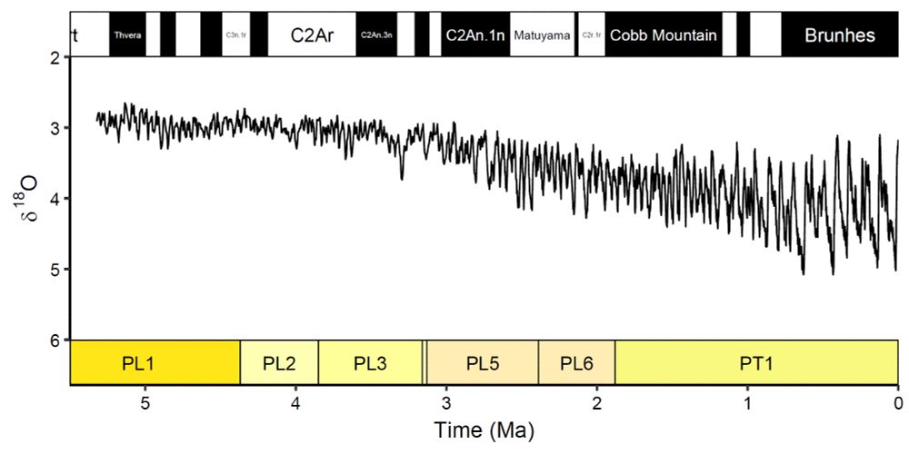
Plot of global benthic δ18O data for 0 – 5.3 Ma (Lisiecki & Raymo, 2005) with geomagnetic polarity subchrons displayed on the top x-axis and planktic foraminiferal primary biozones plotted on the bottom x-axis using the deeptime package.
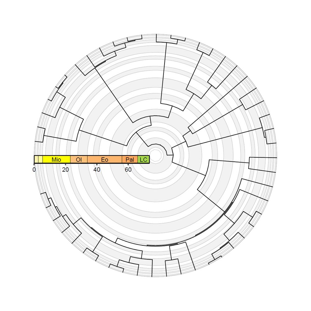
A mammal phylogeny (Garland et al., 1992) plotted in the fan layout using the ggtree and deeptime packages. The greyscale concentric circles in the background indicate geological stages, whereas the linear colored timescale indicates geological epochs.
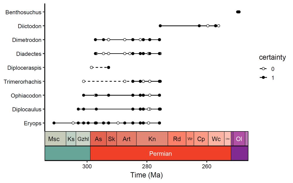
Early tetrapod occurrence data (Jones et al., 2023) plotted as a taxonomic/biostratigraphic range plot using the geom_points_range() function from the deeptime package.
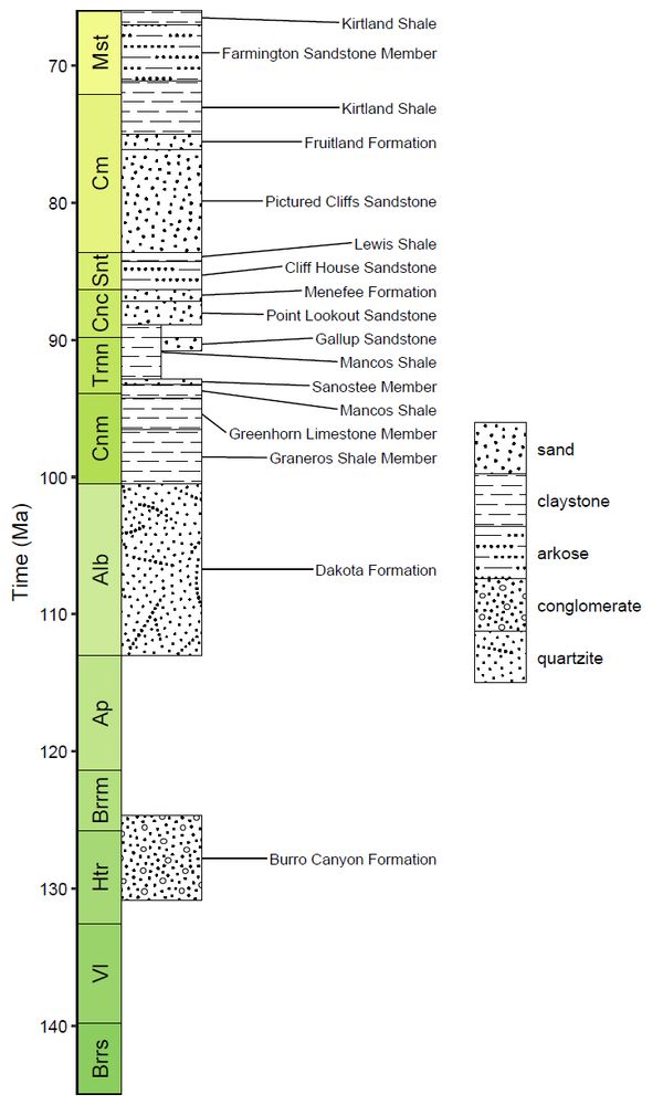
A stratigraphic column of Cretaceous lithostratigraphic units from the San Juan Basin, USA. The deeptime package has been used to add pattern fill which indicate the primary lithologies of the units as reported by the Macrostrat API (Peters et al., 2018) via the rmacrostrat R package (Jones et al., 2024).
📢 deeptime: an R package that facilitates highly customizable and reproducible visualizations of data over geological time intervals
🔗 doi.org/10.1080/2096...
Fully #openaccess in @bigearthdata1.bsky.social with insight about deeptime📦 development and code examples!
#rstats #geology #paleontology
06.08.2025 13:06 — 👍 116 🔁 45 💬 3 📌 3
They/them
Interests: Math. Engineering. Engineering Games. 3d printing and industrial design. Education.
Job: SRE at a tech company working on L7 Networking & Load Balancing.
Proud Liberal 💙 Vote Blue and Save Democracy 💙 Serve as a Trustee for local public library - we must have a literate and educated society. Pro-Choice and Resister. Anti fascism. Traveler - believe there is joy in the journey. DM=Block
Associate Professor of Geography at Miami University, Ohio, USA. Remote sensing, fire, landscape ecology, physical geography, natural hazards. Header photo: sunset in Naivasha, Kenya, July 2023 🇰🇪
Senior Duty Meteorologist at NWS/NCO. Formerly WPC and KEY, MEG, SEW WFOs. Remote sensing focus. Mississippi State alumnus. Round Earther.
Development econ PhD Student at Goethe Universität Frankfurt and WZB.
Doing research at the corner of development, transport and remote sensing.
https://cannoncloud.github.io/
You can find he/him knitting silly hats or riding funny bikes.
Researches pyroecophysiology, fire ecology, remote sensing, fire social science, lidar, and anything else that interests me. Prof and Chair - Earth and Spatial Sciences - College of Science - University of Idaho
Latest news about strong volcanic eruptions detected by Sentinel-5p/TROPOMI #Sentinel-5p #TROPOMI #S5P.
Posts are by P. Hedelt, DLR Remote Sensing Technology Institute (atmos.eoc.dlr.de): @dlr-en.bsky.social
Assistant Professor @ Virginia Commonwealth University; displaced Forest Service scientist; ecosystem ecologist with a remote sensing problem; standard time apologist; lover of loud, noisy, weird music.
🌱 PhD researcher @rbgkew.bsky.social & @royalholloway.bsky.social
🌳 Landscape ecology | Nature-based Solutions | Multifunctional landscapes | Remote sensing | Ecological restoration
http://linktr.ee/guivcastro
M.Sc. Graduate, KNT University
Remote Sensing | Photogrammetry
---→ Environmental Monitoring, Forest Ecology, Wildfire, UAV Photogrammetry, Bundle Adjustment, Canopy Cover
#RemoteSensing #Photogrammetry #UAV #Drone #DeepLearning #GIS
MGIS | Conservation GIS & Remote Sensing | The things we do for love.
https://www.wildlifegis.com
ML for remote sensing @Mila_Quebec * UdeM x McGill CS alum
Interests: Responsible ML for climate & societal impacts, STS, FATE, AI Ethics & Safety
prev: SSofCS lab
📍🇨🇦 Montreal (allegedly)
TW: @XMichellelinX
https://mchll-ln.github.io/
Professor, researcher, musician: mountain glaciers, snow, water, weather, climate change, remote sensing, community adaptation, and EDI in science.
www.moshlab.org
Living in Lheidlih T’enneh territory
(he/him/il/anti-fascist)
Paleotopographer. Asking how people changed landscapes and landscapes changed people.
GIS, remote sensing, archaeology.
Tinkerer. Aspiring bodger.
Glaswegian in Jutland.
Archaeologist at Moesgaard Museum. Personal account. All views my own etc.
Archaeologist 🏺 & Public Educator 🧪
Academic research: archaeology, Bronze & Iron Age Oman, Ancient Ethiopia, archaeobotany, GIS, remote sensing, ethnoarchaeology
https://smitinathan.com
AP reporter covering Washington State, immigration, and environmental issues. Sometimes I use satellite imagery (remote sensing, GIS, etc) to discover what happened and when.
Tips: cattanasio@ap.org
Esri Director of Imagery and Remote Sensing. Pixel pusher. Community builder.
Assoc Prof in remote sensing and GIS, Univ of Gothenburg, Sweden.
#drones, #UAV, #EarthObservation, #EO, #satellites, #vegetation change, #permafrost, #peatlands, #subarctic, #mountains, #geospatial
Associate professor, Landscape archaeologist, early medieval and Roman landscapes, frontiers and borders, spatial arrangements of the built environment, GIS, remote sensing, human-environment interactions.