A satellite picture of a desert region showing eroded ridges and valleys. The terrain features layered sedimentary rock formations with colors ranging from red and orange to tan and gray.
Chile
🌎 : maps.app.goo.gl/j3bJ1YkRmwXR...
4K link : i.imgur.com/9SYbR14.jpeg
28.09.2025 13:04 — 👍 44 🔁 12 💬 0 📌 0

The amazingly astonishing Assiniboine River, Manitoba, Canada, again.
30.09.2025 01:06 — 👍 68 🔁 12 💬 3 📌 0

An embroidery landscape depicting an aerial view of an equestrian farm. Green fields cut through with light paths and red farm houses, complete with a woodland and wild meadow area in the top.
A past embroidery commission I forgot to share on here... an aerial view of an equestrian farm somewhere in America! This was such a lovely landscape is embroider: the horse fields and red farm houses are so pleasing :) such a soothing green landscape 💚
29.09.2025 14:49 — 👍 735 🔁 159 💬 7 📌 6

A satellite picture of a desert region showing eroded ridges and valleys. The terrain features layered sedimentary rock formations with colors ranging from red and orange to tan and gray.
Chile
🌎 : maps.app.goo.gl/j3bJ1YkRmwXR...
4K link : i.imgur.com/9SYbR14.jpeg
28.09.2025 13:04 — 👍 44 🔁 12 💬 0 📌 0

A satellite picture of a residential area featuring circular clusters of houses arranged in a winding pattern, surrounded by water canals. The design resembles islands connected by internal roads, with traditional grid-like neighborhoods and larger buildings surrounding the central serpentine layout.
Jumeirah Islands - Dubai - UAE
🌏 : maps.app.goo.gl/kkth8Co3vecA...
4K link : i.imgur.com/JOgXYGl.jpeg
17.09.2025 11:45 — 👍 19 🔁 7 💬 0 📌 0

A satellite picture of a mountainous desert landscape. The upper and central areas feature rugged mountain ridges, while the lower right displays sandy dunes and eroded valleys in warm brown and orange tones.
Mali
🌍 : maps.app.goo.gl/SMoZ3ZihRGPN...
4K link : i.imgur.com/5VDRm0k.jpeg
19.09.2025 20:26 — 👍 25 🔁 11 💬 1 📌 0

Relative elevation model. Shows meanders and quite a few former river bends over a roughly 40-50 km wide floodplain. Purple upstream to blue downstream.
The Indus River between Guddu and Sukkur, Pakistan.
18.09.2025 22:26 — 👍 28 🔁 6 💬 1 📌 0
I've been fooled by my eyes then, thanks for the precision
19.09.2025 21:09 — 👍 1 🔁 0 💬 0 📌 0

A satellite picture of a mountainous desert landscape. The upper and central areas feature rugged mountain ridges, while the lower right displays sandy dunes and eroded valleys in warm brown and orange tones.
Mali
🌍 : maps.app.goo.gl/SMoZ3ZihRGPN...
4K link : i.imgur.com/5VDRm0k.jpeg
19.09.2025 20:26 — 👍 25 🔁 11 💬 1 📌 0
I have not ! Just looked it up, it looks quite interesting ! Not sure I can produce a satisfying picture but I'm glad to have learned about it, thank you :)
18.09.2025 06:48 — 👍 1 🔁 0 💬 1 📌 0

A satellite picture of a residential area featuring circular clusters of houses arranged in a winding pattern, surrounded by water canals. The design resembles islands connected by internal roads, with traditional grid-like neighborhoods and larger buildings surrounding the central serpentine layout.
Jumeirah Islands - Dubai - UAE
🌏 : maps.app.goo.gl/kkth8Co3vecA...
4K link : i.imgur.com/JOgXYGl.jpeg
17.09.2025 11:45 — 👍 19 🔁 7 💬 0 📌 0

A starfield surrounds a large red nebula. The nebula has many flowing waves and folds. Please see the explanation for more detailed information.
🔭 The Great Lacerta Nebula
Image Credit & Copyright: Ian Moehring & Kevin Roylance
apod.nasa.gov/apod/ap25091...
10.09.2025 08:00 — 👍 148 🔁 38 💬 2 📌 1

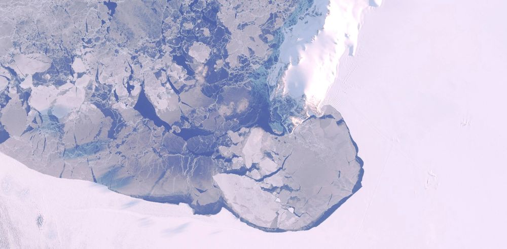
A satellite picture of a polar coastal region with a rugged, snow-covered landmass on the right. Floating ice chunks scatter across the dark swirling water. On the shore, two research bases—one with clustered buildings and another smaller one with green roofing out against the icy terrain.
Mc Murdo station and Scott station - Antarctica
🌎 : maps.app.goo.gl/eYqgsfSmY1mW...
4K link : i.imgur.com/Y7JFjxX.jpeg
07.09.2025 16:20 — 👍 42 🔁 12 💬 1 📌 0

Sentinel-2 is still in winter mode over the area, no images yet. This one is from March 13, Level-1 Tonemapped Natural Color. link.dataspace.copernicus.eu/1w5c
08.09.2025 08:40 — 👍 5 🔁 1 💬 1 📌 0
The area is very different looking depending on the seasons yes ! I saw some winter pictures by going through the archive from Google Earth and there was what I assume is a large landing strip drawn on top of the sea, which was totally frozen over, of course
08.09.2025 08:46 — 👍 0 🔁 0 💬 0 📌 0

A satellite picture of a polar coastal region with a rugged, snow-covered landmass on the right. Floating ice chunks scatter across the dark swirling water. On the shore, two research bases—one with clustered buildings and another smaller one with green roofing out against the icy terrain.
Mc Murdo station and Scott station - Antarctica
🌎 : maps.app.goo.gl/eYqgsfSmY1mW...
4K link : i.imgur.com/Y7JFjxX.jpeg
07.09.2025 16:20 — 👍 42 🔁 12 💬 1 📌 0

Made this two days ago.
04.09.2025 20:27 — 👍 19 🔁 4 💬 0 📌 0

HiPOD: Layers Blanket a Crater Floor
This image shows a layered rock formation within Jiji Crater that has eroded into buttes and stair-like layers. Our image also indicates that much of the formation has eroded away relative to what has remained.
More: uahirise.org/hipod/ESP_06...
#Mars #NASA
05.09.2025 13:18 — 👍 62 🔁 18 💬 0 📌 0

Photo of a lichen growing flat on the surface of rock. The lichen is oval in shape and cream coloured with orange discs (apothecia) dotted mainly around is outside edge.
A beautiful orange rock posy lichen (Rhizoplaca chrysoleuca), from my time in Yellowknife, NT, Canada. #lichen #fungifriends
01.09.2025 12:37 — 👍 372 🔁 74 💬 3 📌 6

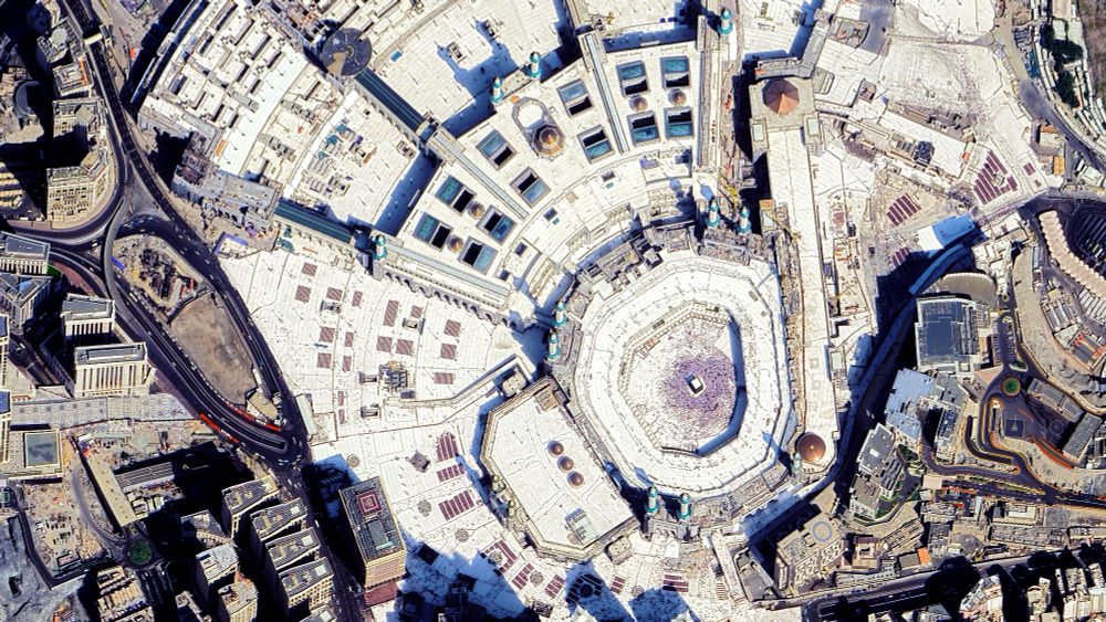
A satellite picture of Masjid al-Haram in Mecca, showing the large mosque complex with multiple minarets, open courtyards, and the Kaaba at its center. Surrounding areas include dense urban buildings and visible construction activity.

Same picture but zoomed in on the Kaaba
Masjid al-Haram and Kaaba - Mecca - Saudi Arabia
🌏 : maps.app.goo.gl/YwT3mcWEhwtR...
4K link : imgur.com/a/DiuLxrj
31.08.2025 17:36 — 👍 32 🔁 7 💬 1 📌 0
that's some impressive resolution there, thanks for sharing !
31.08.2025 20:33 — 👍 2 🔁 0 💬 1 📌 0

This 30 cm-class image of Mecca🕋, Saudi Arabia. 🛰 maxar.com
31.08.2025 20:22 — 👍 17 🔁 5 💬 1 📌 0
I honestly don't know much about its purpose but it is the Kaaba, yes
31.08.2025 20:12 — 👍 0 🔁 0 💬 0 📌 0

A satellite picture of Masjid al-Haram in Mecca, showing the large mosque complex with multiple minarets, open courtyards, and the Kaaba at its center. Surrounding areas include dense urban buildings and visible construction activity.

Same picture but zoomed in on the Kaaba
Masjid al-Haram and Kaaba - Mecca - Saudi Arabia
🌏 : maps.app.goo.gl/YwT3mcWEhwtR...
4K link : imgur.com/a/DiuLxrj
31.08.2025 17:36 — 👍 32 🔁 7 💬 1 📌 0
gold & blue and a bit of Escher
30.08.2025 20:42 — 👍 65 🔁 15 💬 1 📌 1

Storms.
NASA/JPL-Caltech/SwRI/MSSS/Kevin M. Gill
Storm systems on Jupiter, NASA Juno Perijove 38.
flic.kr/p/2mNqMpK
31.08.2025 01:51 — 👍 244 🔁 55 💬 7 📌 3

A satellite picture of a dry, sparsely vegetated landscape featuring two prominent circular geological formations—one large eroded crater surrounded by farmland, and one smaller volcanic cone—amid patchy agricultural fields in varying shades of brown and beige.
Ethiopia
🌍 : maps.app.goo.gl/PHcDngweff4Q...
4K link : i.imgur.com/JoyEOty.jpeg
26.08.2025 17:22 — 👍 89 🔁 22 💬 1 📌 0

Le satellite européen Biomass, récemment mis en orbite, a observé la Bolivie.
Chaque couleur de cette image radar révèle des caractéristiques distinctes du paysage :
vert - forêt tropicale
rouges - plaines inondables boisées et zones humides,
bleu/violet - prairies
noir - rivières et lacs
1/2
27.08.2025 08:54 — 👍 44 🔁 7 💬 1 📌 2
C'est vrai qu'il y a de ça maintenant que tu le dis !
26.08.2025 18:10 — 👍 0 🔁 0 💬 0 📌 0
International Hydrology and Water Resources | Elevation models | Mapping | Landscape, Groundwater and Ecohydrological Systems Analyses
Earth Observation Community Evangelist, science communicator, limnologist, remote sensing guy. Big family. Likes bicycles, geology, geomorphology and being outdoors. Night train enjoyer.
Watching our planet 🌍 from space 🛰 to identify climate change, deforestation & natural disasters.
#EarthObservation #ClimateChange #Environment
✖️ x.com/WED_explorer
British Solar Astrophysicist at the Laboratory of Atmospheric & Space Physics ☀️ Author of ‘Space Hazards’ and 'The Sun: Beginner’s Guide to Our Local Star' - (views my own)
Boutiquière d'affiches sur helloclermont.fr et finke.fr
All images processed by me in EO Browser & Copernicus Browser.
Image credits:
ESA/CopernicusEU for Sentinel and NASA/USGS for Landsat.
This is the official God Is An Astronaut Bluesky account.
https://linktr.ee/godisanastronaut
Artist based in the Hudson Valley
www.juliawhitneybarnes.com
PhD Researcher at the EUI in Firenze, studying the history of ESA's Horizon 2000 scientific campaign
28
He/him
Amateur astronomer and astrophotographer, including Sirius, meteors, noctilucent clouds and aurora. Articles and pictures published in books and magazines. Been on TV and radio talking about astronomy. Always need more sleep.
Enjoying the history of the European space adventure. Continuing from @ESA_History on X
See our other channels: https://linktr.ee/european_space_history
A Nature journal dedicated to presenting the very best research across the disciplines of astronomy, astrophysics, cosmology and planetary science.📡
www.nature.com/natastron
European Space Agency's Climate Team, often posting about ESA's Climate Change Initiative programme - climate.esa.int
Astronaut, back on Earth after 3 spaceflights. For events & media, please write to info@chrishadfield.ca. Order books at http://chrishadfield.ca/books
#50YearsOfESA: we're the European Space Agency, keeping you posted on European space activities.
Please see our Privacy Notice: https://esa.int/connectwithus
Concept art for non-existent space programs. No AI, using only FOSS (Blender and GIMP)
Short stories in Linktree.
linktr.ee/element115art
Aquatic ecologist, PhD student @LeibnizIGB
All things #plankton
@aquacosm-ecr.bsky.social co-founder
😺 mom
Astrophotographer based in BC Canada, some wildlife and landscapes thrown in there ✨📷🔭 🇨🇦. All images my own, unless repost.
www.astrobin.com/users/debraceravolo/
www.instagram.com/debraceravolo/
www.flickr.com/people/debraceravolo/
Photo sharing bot for planetary and deep space images.
Run by @kevinmgill.bsky.social
Content providers added with permission.


