ZCZC HFOTWOCP ALL<br>TTAA00 PHFO DDHHMM<br><br>Tropical Weather Outlook<br>NWS Central Pacific Hurricane Center Honolulu HI<br>Issued by NWS National Hurricane Center Miami FL<br>200 AM HST Tue Aug 05 2025<br><br>For the central North Pacific...between 140W and 180W:<br><br>Active Systems:<br>The National Hurricane Center is issuing advisories on Tropical<br>Storm Henriette, located well southwest of the Baja California<br>Peninsula. Henriette is expected to move into the Central Pacific<br>basin Thursday night or Friday morning.<br><br>Tropical cyclone formation is not expected during the next 7 days.<br><br><br>Forecaster Roberts<br><br><br>
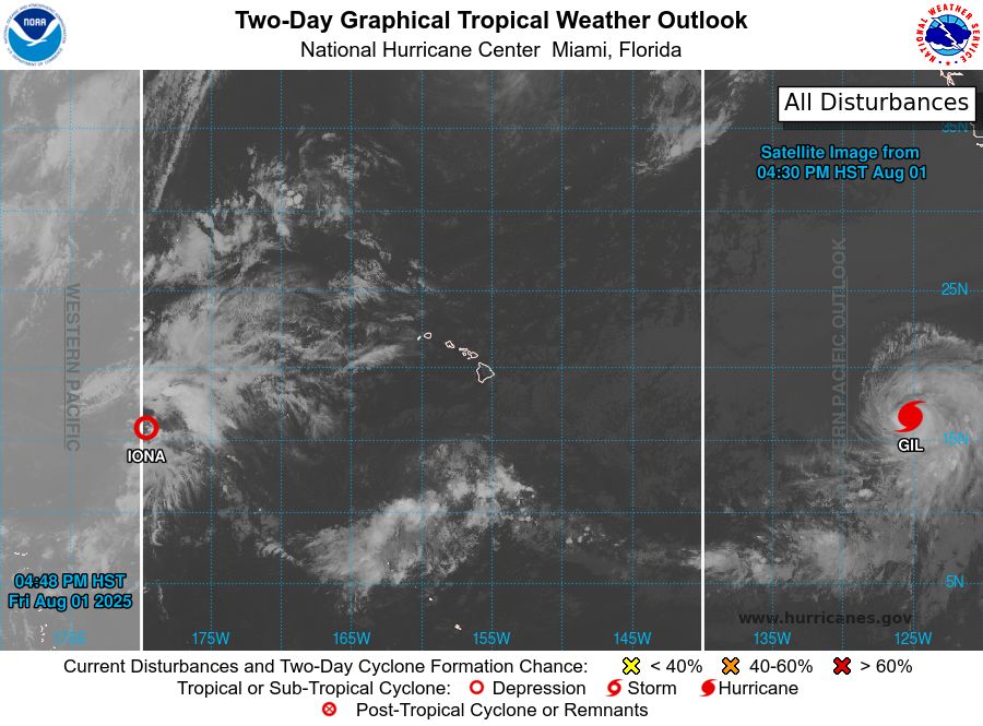
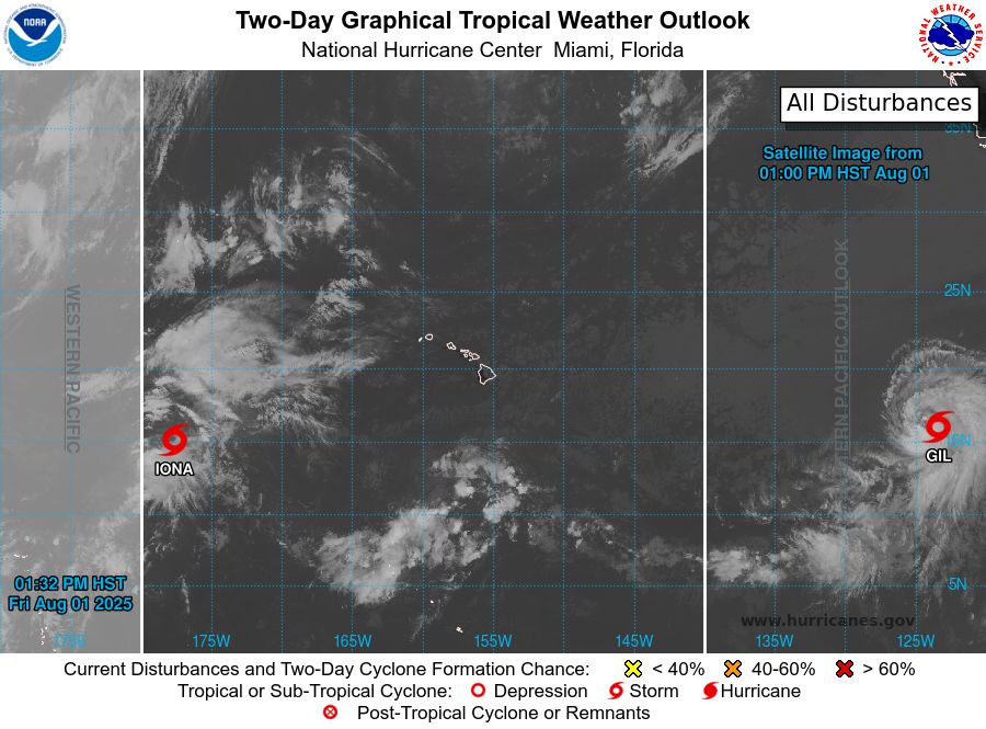
Central North Pacific 2-Day Graphical Outlook Image

Central North Pacific 7-Day Graphical Outlook Image
CPHC Central North Pacific Outlook update for Tue, 05 Aug 2025 11:26:37 UTC
Additional Details Here.
05.08.2025 11:30 — 👍 0 🔁 0 💬 0 📌 0
ZCZC HFOTWOCP ALL<br>TTAA00 PHFO DDHHMM<br><br>Tropical Weather Outlook<br>NWS Central Pacific Hurricane Center Honolulu HI<br>Issued by NWS National Hurricane Center Miami FL<br>800 PM HST Mon Aug 04 2025<br><br>For the central North Pacific...between 140W and 180W:<br><br>Active Systems:<br>The National Hurricane Center is issuing advisories on Tropical<br>Storm Henriette, located well southwest of the Baja California<br>Peninsula. Henriette is expected to move into the Central Pacific<br>basin Thursday night or Friday.<br><br>Tropical cyclone formation is not expected during the next 7 days.<br><br><br>Public advisories on Tropical Storm Henriette are issued under<br>WMO header WTPZ33 KNHC and under AWIPS header MIATCPEP3.<br>Forecast/Advisories on Tropical Storm Henriette are issued under<br>WMO header WTPZ23 KNHC and under AWIPS header MIATCMEP3.<br><br><br>Forecaster Jelsema<br><br><br>
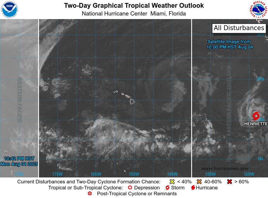
Central North Pacific 2-Day Graphical Outlook Image

Central North Pacific 7-Day Graphical Outlook Image
CPHC Central North Pacific Outlook update for Tue, 05 Aug 2025 08:42:34 UTC
Additional Details Here.
05.08.2025 08:50 — 👍 0 🔁 0 💬 0 📌 0
ZCZC HFOTWOCP ALL<br>TTAA00 PHFO DDHHMM<br><br>Tropical Weather Outlook<br>NWS Central Pacific Hurricane Center Honolulu HI<br>Issued by NWS National Hurricane Center Miami FL<br>800 PM HST Mon Aug 04 2025<br><br>For the central North Pacific...between 140W and 180W:<br><br>Active Systems:<br>The National Hurricane Center is issuing advisories on Tropical<br>Storm Henriette, located well southwest of the Baja California<br>Peninsula. Henriette is expected to move into the Central Pacific<br>basin Thursday night or Friday.<br><br>Tropical cyclone formation is not expected during the next 7 days.<br><br><br>Public advisories on Tropical Storm Henriette are issued under<br>WMO header WTPZ33 KNHC and under AWIPS header MIATCPEP3.<br>Forecast/Advisories on Tropical Storm Henriette are issued under<br>WMO header WTPZ23 KNHC and under AWIPS header MIATCMEP3.<br><br><br>Forecaster Jelsema<br><br><br>
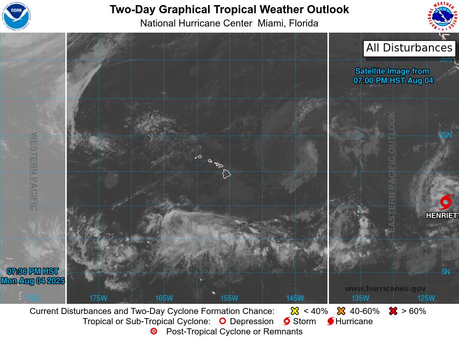
Central North Pacific 2-Day Graphical Outlook Image

Central North Pacific 7-Day Graphical Outlook Image
CPHC Central North Pacific Outlook update for Tue, 05 Aug 2025 05:36:29 UTC
Additional Details Here.
05.08.2025 05:40 — 👍 1 🔁 0 💬 0 📌 0

ZCZC HFOTWOCP ALL<br>TTAA00 PHFO DDHHMM<br><br>Tropical Weather Outlook<br>NWS Central Pacific Hurricane Center Honolulu HI<br>Issued by NWS National Hurricane Center Miami FL<br>200 PM HST Mon Aug 04 2025<br><br>For the central North Pacific...between 140W and 180W:<br><br>Active Systems:<br>The National Hurricane Center is issuing advisories on Tropical<br>Storm Henriette, located well southwest of the Baja California<br>Peninsula. Henriette is expected to move into the Central Pacific<br>basin Thursday night or Friday.<br><br>Tropical cyclone formation is not expected during the next 7 days.<br><br><br>Public advisories on Tropical Storm Henriette are issued under<br>WMO header WTPZ33 KNHC and under AWIPS header MIATCPEP3.<br>Forecast/Advisories on Tropical Storm Henriette are issued under<br>WMO header WTPZ23 KNHC and under AWIPS header MIATCMEP3.<br><br><br>Forecaster Jelsema<br><br><br>
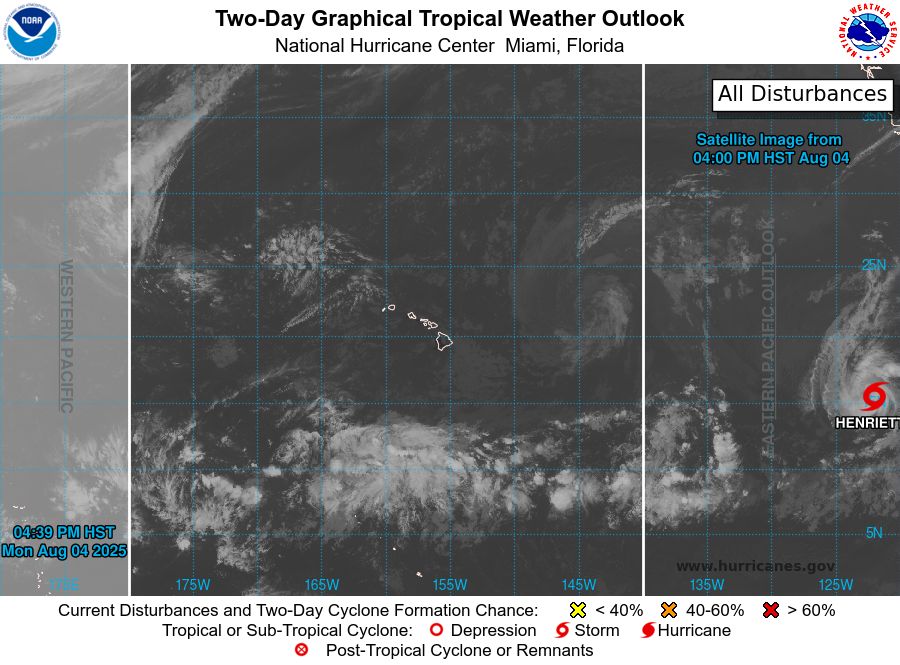
Central North Pacific 2-Day Graphical Outlook Image
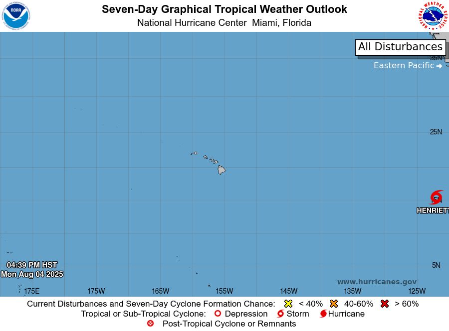
Central North Pacific 7-Day Graphical Outlook Image
CPHC Central North Pacific Outlook update for Tue, 05 Aug 2025 02:39:39 UTC
Additional Details Here.
05.08.2025 02:50 — 👍 0 🔁 0 💬 0 📌 0
ZCZC HFOTWOCP ALL<br>TTAA00 PHFO DDHHMM<br><br>Tropical Weather Outlook<br>NWS Central Pacific Hurricane Center Honolulu HI<br>Issued by NWS National Hurricane Center Miami FL<br>200 PM HST Mon Aug 04 2025<br><br>For the central North Pacific...between 140W and 180W:<br><br>Active Systems:<br>The National Hurricane Center is issuing advisories on Tropical<br>Storm Henriette, located well southwest of the Baja California<br>Peninsula. Henriette is expected to move into the Central Pacific<br>basin Thursday night or Friday.<br><br>Tropical cyclone formation is not expected during the next 7 days.<br><br><br>Public advisories on Tropical Storm Henriette are issued under<br>WMO header WTPZ33 KNHC and under AWIPS header MIATCPEP3.<br>Forecast/Advisories on Tropical Storm Henriette are issued under<br>WMO header WTPZ23 KNHC and under AWIPS header MIATCMEP3.<br><br><br>Forecaster Jelsema<br><br><br>
Central North Pacific 2-Day Graphical Outlook Image

Central North Pacific 7-Day Graphical Outlook Image
CPHC Central North Pacific Outlook update for Mon, 04 Aug 2025 23:22:18 UTC
Additional Details Here.
04.08.2025 23:30 — 👍 0 🔁 0 💬 0 📌 0
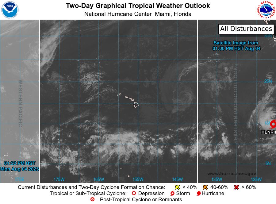
ZCZC HFOTWOCP ALL<br>TTAA00 PHFO DDHHMM<br><br>Tropical Weather Outlook<br>NWS Central Pacific Hurricane Center Honolulu HI<br>Issued by NWS National Hurricane Center Miami FL<br>800 AM HST Mon Aug 04 2025<br><br>For the central North Pacific...between 140W and 180W:<br><br>Active Systems:<br>The National Hurricane Center is issuing advisories on Tropical<br>Depression Eight-E, located well southwest of the Baja California<br>Peninsula.<br><br>Tropical cyclone formation is not expected during the next 7 days.<br><br><br>Public advisories on Tropical Depression Eight-E are issued under<br>WMO header WTPZ33 KNHC and under AWIPS header MIATCPEP3.<br>Forecast/Advisories on Tropical Depression Eight-E are issued under<br>WMO header WTPZ23 KNHC and under AWIPS header MIATCMEP3.<br><br><br>Forecaster Roberts<br><br><br>
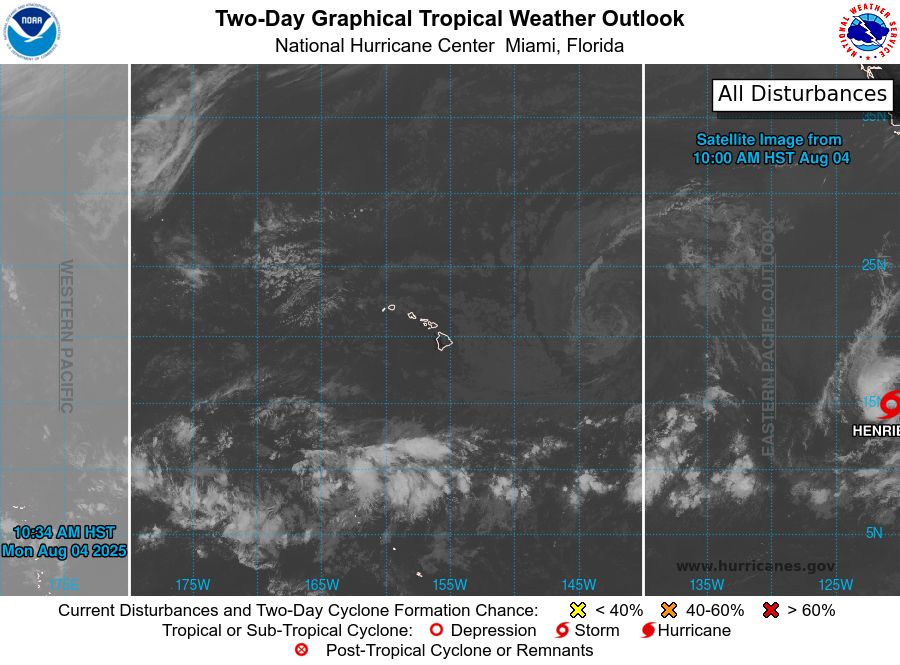
Central North Pacific 2-Day Graphical Outlook Image

Central North Pacific 7-Day Graphical Outlook Image
CPHC Central North Pacific Outlook update for Mon, 04 Aug 2025 20:34:36 UTC
Additional Details Here.
04.08.2025 20:40 — 👍 0 🔁 0 💬 0 📌 0
ZCZC HFOTWOCP ALL<br>TTAA00 PHFO DDHHMM<br><br>Tropical Weather Outlook<br>NWS Central Pacific Hurricane Center Honolulu HI<br>Issued by NWS National Hurricane Center Miami FL<br>800 AM HST Mon Aug 04 2025<br><br>For the central North Pacific...between 140W and 180W:<br><br>Active Systems:<br>The National Hurricane Center is issuing advisories on Tropical<br>Depression Eight-E, located well southwest of the Baja California<br>Peninsula.<br><br>Tropical cyclone formation is not expected during the next 7 days.<br><br><br>Public advisories on Tropical Depression Eight-E are issued under<br>WMO header WTPZ33 KNHC and under AWIPS header MIATCPEP3.<br>Forecast/Advisories on Tropical Depression Eight-E are issued under<br>WMO header WTPZ23 KNHC and under AWIPS header MIATCMEP3.<br><br><br>Forecaster Roberts<br><br><br>
Central North Pacific 2-Day Graphical Outlook Image

Central North Pacific 7-Day Graphical Outlook Image
CPHC Central North Pacific Outlook update for Mon, 04 Aug 2025 17:18:24 UTC
Additional Details Here.
04.08.2025 17:20 — 👍 0 🔁 0 💬 0 📌 0
ZCZC HFOTWOCP ALL<br>TTAA00 PHFO DDHHMM<br><br>Tropical Weather Outlook<br>NWS Central Pacific Hurricane Center Honolulu HI<br>Issued by NWS National Hurricane Center Miami FL<br>200 AM HST Mon Aug 04 2025<br><br>For the central North Pacific...between 140W and 180W:<br><br>Active Systems:<br>The National Hurricane Center is issuing advisories on newly formed<br>Tropical Depression Eight-E, located well southwest of the Baja<br>California Peninsula.<br><br>Tropical cyclone formation is not expected during the next 7 days.<br><br><br>Public advisories on Tropical Depression Eight-E are issued under<br>WMO header WTPZ33 KNHC and under AWIPS header MIATCPEP3.<br>Forecast/Advisories on Tropical Depression Eight-E are issued under<br>WMO header WTPZ23 KNHC and under AWIPS header MIATCMEP3.<br><br><br>Forecaster Gibbs<br><br><br>
Central North Pacific 2-Day Graphical Outlook Image

Central North Pacific 7-Day Graphical Outlook Image
CPHC Central North Pacific Outlook update for Mon, 04 Aug 2025 11:15:39 UTC
Additional Details Here.
04.08.2025 11:20 — 👍 0 🔁 0 💬 0 📌 0

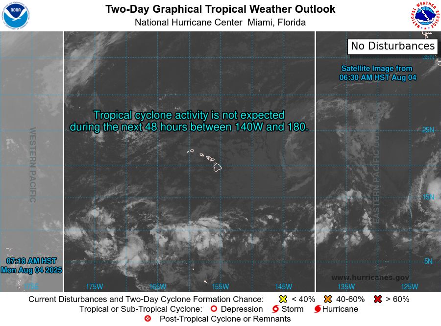
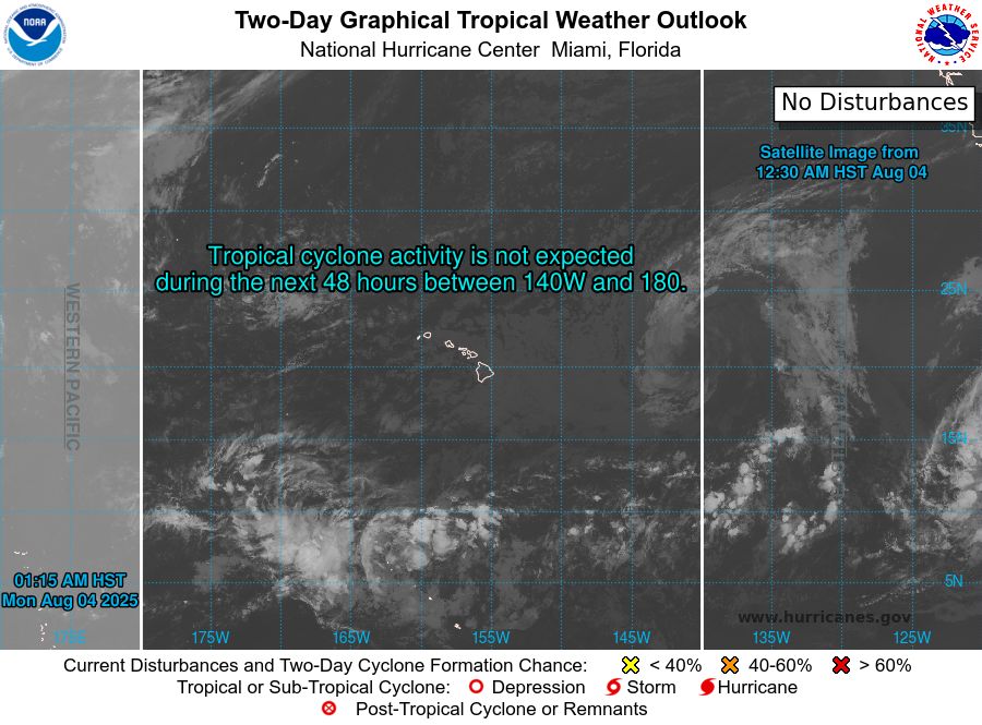
ZCZC HFOTWOCP ALL<br>TTAA00 PHFO DDHHMM<br><br>Tropical Weather Outlook<br>NWS Central Pacific Hurricane Center Honolulu HI<br>Issued by NWS National Hurricane Center Miami FL<br>800 PM HST Sun Aug 03 2025<br><br>For the central North Pacific...between 140W and 180W:<br><br>Tropical cyclone formation is not expected during the next 7 days.<br><br><br><br><br>Forecaster Gibbs<br><br><br>
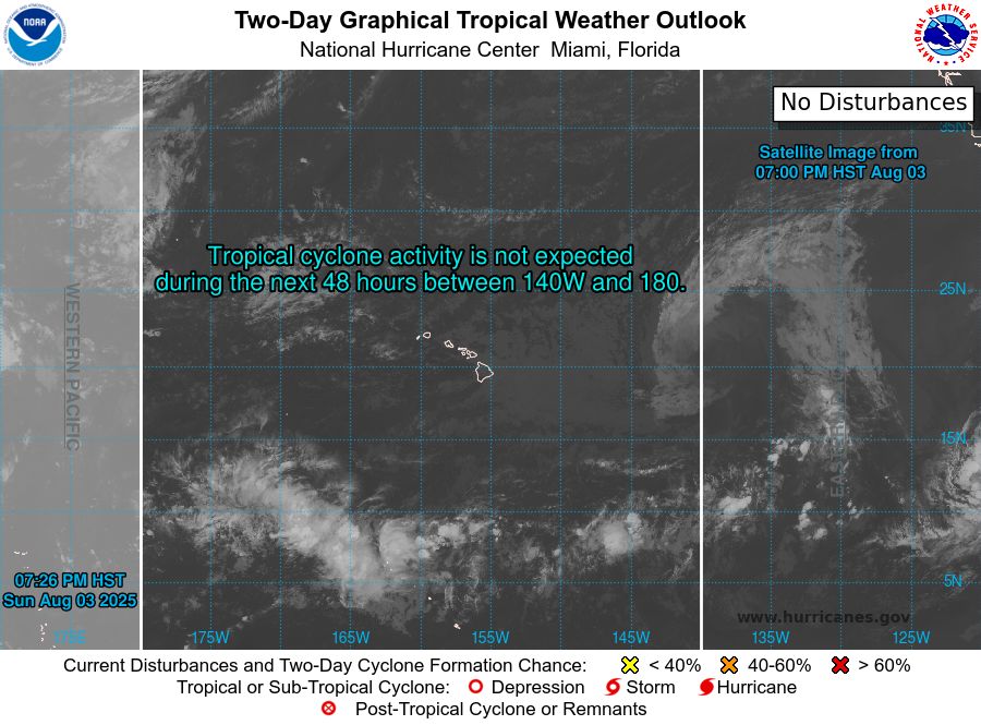
Central North Pacific 2-Day Graphical Outlook Image
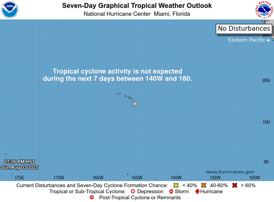
Central North Pacific 7-Day Graphical Outlook Image
CPHC Central North Pacific Outlook update for Mon, 04 Aug 2025 05:26:23 UTC
Additional Details Here.
04.08.2025 05:30 — 👍 0 🔁 0 💬 0 📌 0
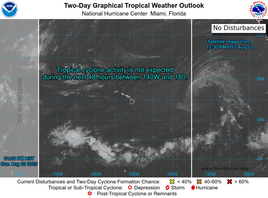
ZCZC HFOTWOCP ALL<br>TTAA00 PHFO DDHHMM<br><br>Tropical Weather Outlook<br>NWS Central Pacific Hurricane Center Honolulu HI<br>Issued by NWS National Hurricane Center Miami FL<br>200 PM HST Sun Aug 03 2025<br><br>For the central North Pacific...between 140W and 180W:<br><br>Tropical cyclone formation is not expected during the next 7 days.<br><br><br><br><br>Forecaster Pasch<br><br><br>
Central North Pacific 2-Day Graphical Outlook Image

Central North Pacific 7-Day Graphical Outlook Image
CPHC Central North Pacific Outlook update for Sun, 03 Aug 2025 23:10:49 UTC
Additional Details Here.
03.08.2025 23:20 — 👍 1 🔁 0 💬 0 📌 0
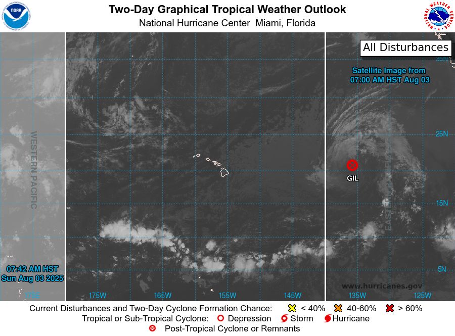
ZCZC HFOTWOCP ALL<br>TTAA00 PHFO DDHHMM<br><br>Tropical Weather Outlook<br>NWS Central Pacific Hurricane Center Honolulu HI<br>Issued by NWS National Hurricane Center Miami FL<br>800 AM HST Sun Aug 03 2025<br><br>For the central North Pacific...between 140W and 180W:<br><br>Active Systems:<br>The National Hurricane Center has issued the last advisory on<br>Post-Tropical Cyclone Gil, located well east of the Hawaiian<br>Islands.<br><br>Tropical cyclone formation is not expected during the next 7 days.<br><br><br><br><br>Forecaster Bucci/Rosado-Vazquez<br><br><br>
Central North Pacific 2-Day Graphical Outlook Image
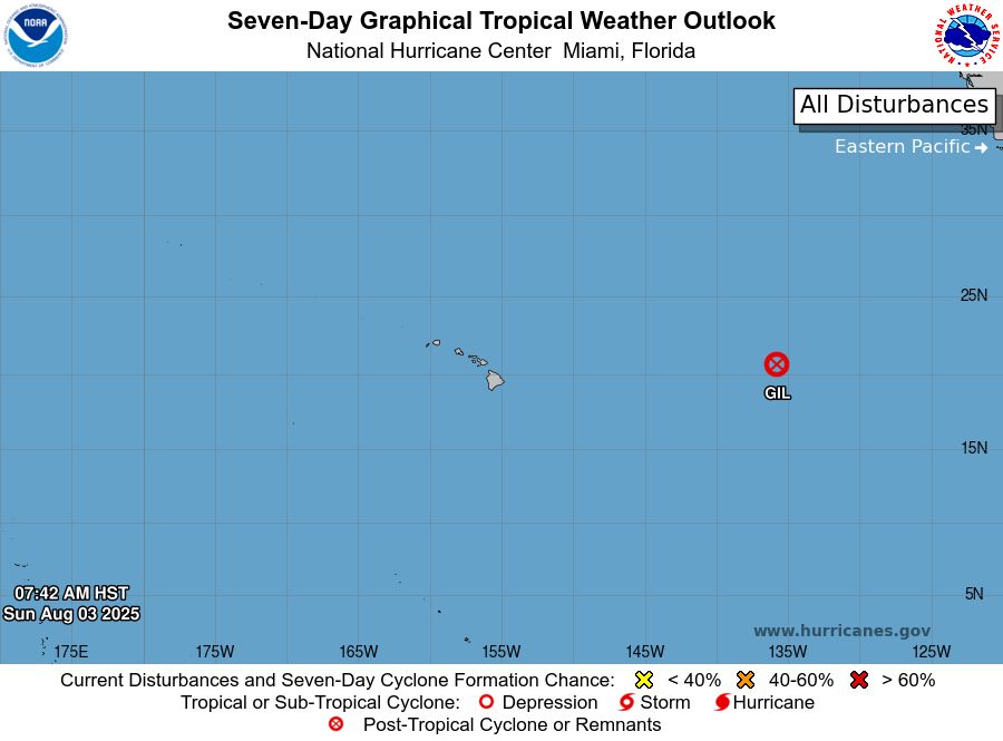
Central North Pacific 7-Day Graphical Outlook Image
CPHC Central North Pacific Outlook update for Sun, 03 Aug 2025 17:42:17 UTC
Additional Details Here.
03.08.2025 17:50 — 👍 0 🔁 0 💬 0 📌 0
ZCZC HFOTWOCP ALL<br>TTAA00 PHFO DDHHMM<br><br>Tropical Weather Outlook<br>NWS Central Pacific Hurricane Center Honolulu HI<br>Issued by NWS National Hurricane Center Miami FL<br>200 AM HST Sun Aug 03 2025<br><br>For the central North Pacific...between 140W and 180W:<br><br>Active Systems:<br>The National Hurricane Center is issuing advisories on Tropical<br>Storm Gil, located well east of the Hawaiian Islands.<br><br>Tropical cyclone formation is not expected during the next 7 days.<br><br><br><br><br>Forecaster Gibbs<br><br><br>
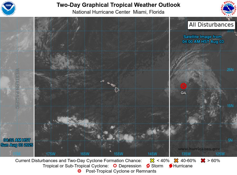
Central North Pacific 2-Day Graphical Outlook Image

Central North Pacific 7-Day Graphical Outlook Image
CPHC Central North Pacific Outlook update for Sun, 03 Aug 2025 14:32:35 UTC
Additional Details Here.
03.08.2025 14:40 — 👍 0 🔁 0 💬 0 📌 0
ZCZC HFOTWOCP ALL<br>TTAA00 PHFO DDHHMM<br><br>Tropical Weather Outlook<br>NWS Central Pacific Hurricane Center Honolulu HI<br>Issued by NWS National Hurricane Center Miami FL<br>200 AM HST Sun Aug 03 2025<br><br>For the central North Pacific...between 140W and 180W:<br><br>Active Systems:<br>The National Hurricane Center is issuing advisories on Tropical<br>Storm Gil, located well east of the Hawaiian Islands.<br><br>Tropical cyclone formation is not expected during the next 7 days.<br><br><br><br><br>Forecaster Gibbs<br><br><br>
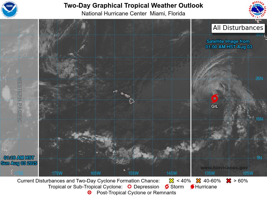
Central North Pacific 2-Day Graphical Outlook Image

Central North Pacific 7-Day Graphical Outlook Image
CPHC Central North Pacific Outlook update for Sun, 03 Aug 2025 11:19:07 UTC
Additional Details Here.
03.08.2025 11:20 — 👍 0 🔁 0 💬 0 📌 0
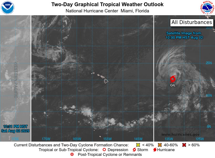
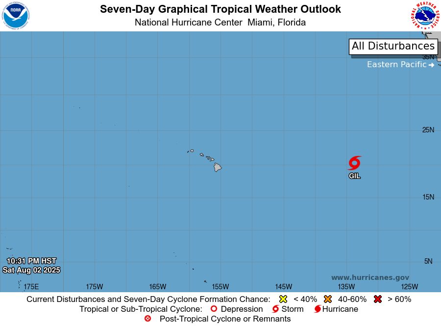
ZCZC HFOTWOCP ALL<br>TTAA00 PHFO DDHHMM<br><br>Tropical Weather Outlook<br>NWS Central Pacific Hurricane Center Honolulu HI<br>Issued by NWS National Hurricane Center Miami FL<br>800 PM HST Sat Aug 02 2025<br><br>For the central North Pacific...between 140W and 180W:<br><br>Active Systems:<br>The National Hurricane Center is issuing advisories on Tropical<br>Storm Gil, located well east of the Hawaiian Islands.<br><br>Tropical cyclone formation is not expected during the next 7 days.<br><br><br>Forecaster Gibbs<br><br><br>
Central North Pacific 2-Day Graphical Outlook Image
Central North Pacific 7-Day Graphical Outlook Image
CPHC Central North Pacific Outlook update for Sun, 03 Aug 2025 08:31:47 UTC
Additional Details Here.
03.08.2025 08:40 — 👍 0 🔁 0 💬 0 📌 0
ZCZC HFOTWOCP ALL<br>TTAA00 PHFO DDHHMM<br><br>Tropical Weather Outlook<br>NWS Central Pacific Hurricane Center Honolulu HI<br>Issued by NWS National Hurricane Center Miami FL<br>800 PM HST Sat Aug 02 2025<br><br>For the central North Pacific...between 140W and 180W:<br><br>Active Systems:<br>The National Hurricane Center is issuing advisories on Tropical<br>Storm Gil, located well east of the Hawaiian Islands.<br><br>Tropical cyclone formation is not expected during the next 7 days.<br><br><br>Forecaster Gibbs<br><br><br>

Central North Pacific 2-Day Graphical Outlook Image

Central North Pacific 7-Day Graphical Outlook Image
CPHC Central North Pacific Outlook update for Sun, 03 Aug 2025 05:04:09 UTC
Additional Details Here.
03.08.2025 05:10 — 👍 0 🔁 0 💬 0 📌 0
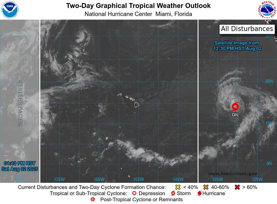
ZCZC HFOTWOCP ALL<br>TTAA00 PHFO DDHHMM<br><br>Tropical Weather Outlook<br>NWS Central Pacific Hurricane Center Honolulu HI<br>Issued by NWS National Hurricane Center Miami FL<br>200 PM HST Sat Aug 02 2025<br><br>For the central North Pacific...between 140W and 180W:<br><br>Active Systems:<br>The National Hurricane Center is issuing advisories on Tropical<br>Storm Gil, located well west of the southern tip of the Baja<br>California peninsula.<br><br>Tropical cyclone formation is not expected during the next 7 days.<br><br><br>Forecaster Berg<br><br><br>
Central North Pacific 2-Day Graphical Outlook Image
Central North Pacific 7-Day Graphical Outlook Image
CPHC Central North Pacific Outlook update for Sun, 03 Aug 2025 02:39:36 UTC
Additional Details Here.
03.08.2025 02:50 — 👍 0 🔁 1 💬 0 📌 0
ZCZC HFOTWOCP ALL<br>TTAA00 PHFO DDHHMM<br><br>Tropical Weather Outlook<br>NWS Central Pacific Hurricane Center Honolulu HI<br>Issued by NWS National Hurricane Center Miami FL<br>200 PM HST Sat Aug 02 2025<br><br>For the central North Pacific...between 140W and 180W:<br><br>Active Systems:<br>The National Hurricane Center is issuing advisories on Tropical<br>Storm Gil, located well west of the southern tip of the Baja<br>California peninsula.<br><br>Tropical cyclone formation is not expected during the next 7 days.<br><br><br>Forecaster Berg<br><br><br>
Central North Pacific 2-Day Graphical Outlook Image

Central North Pacific 7-Day Graphical Outlook Image
CPHC Central North Pacific Outlook update for Sat, 02 Aug 2025 23:10:53 UTC
Additional Details Here.
02.08.2025 23:20 — 👍 0 🔁 0 💬 0 📌 0
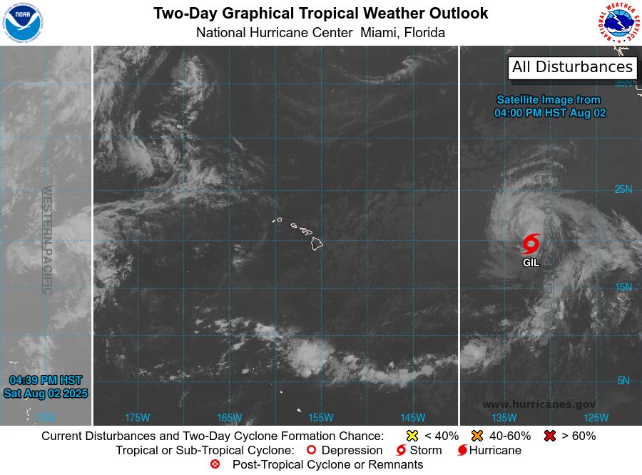
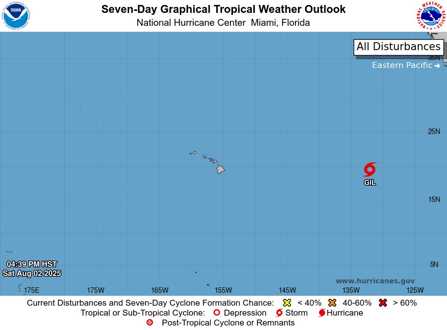
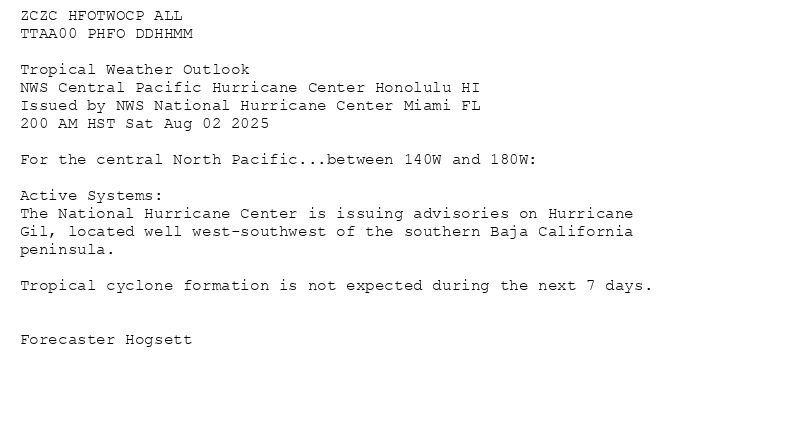
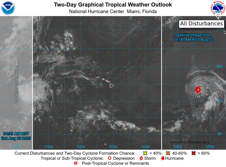
ZCZC HFOTWOCP ALL<br>TTAA00 PHFO DDHHMM<br><br>Tropical Weather Outlook<br>NWS Central Pacific Hurricane Center Honolulu HI<br>Issued by NWS National Hurricane Center Miami FL<br>800 AM HST Sat Aug 02 2025<br><br>For the central North Pacific...between 140W and 180W:<br><br>Active Systems:<br>The National Hurricane Center is issuing advisories on<br>recently-downgraded Tropical Storm Gil, located well<br>west-southwest of the southern Baja California peninsula.<br><br>Tropical cyclone formation is not expected during the next 7 days.<br><br><br>Forecaster Hogsett<br><br><br>

Central North Pacific 2-Day Graphical Outlook Image
Central North Pacific 7-Day Graphical Outlook Image
CPHC Central North Pacific Outlook update for Sat, 02 Aug 2025 20:37:38 UTC
Additional Details Here.
02.08.2025 20:40 — 👍 0 🔁 0 💬 0 📌 0
ZCZC HFOTWOCP ALL<br>TTAA00 PHFO DDHHMM<br><br>Tropical Weather Outlook<br>NWS Central Pacific Hurricane Center Honolulu HI<br>Issued by NWS National Hurricane Center Miami FL<br>800 AM HST Sat Aug 02 2025<br><br>For the central North Pacific...between 140W and 180W:<br><br>Active Systems:<br>The National Hurricane Center is issuing advisories on<br>recently-downgraded Tropical Storm Gil, located well<br>west-southwest of the southern Baja California peninsula.<br><br>Tropical cyclone formation is not expected during the next 7 days.<br><br><br>Forecaster Hogsett<br><br><br>
Central North Pacific 2-Day Graphical Outlook Image

Central North Pacific 7-Day Graphical Outlook Image
CPHC Central North Pacific Outlook update for Sat, 02 Aug 2025 17:31:51 UTC
Additional Details Here.
02.08.2025 17:40 — 👍 0 🔁 0 💬 0 📌 0
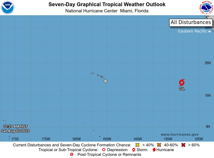
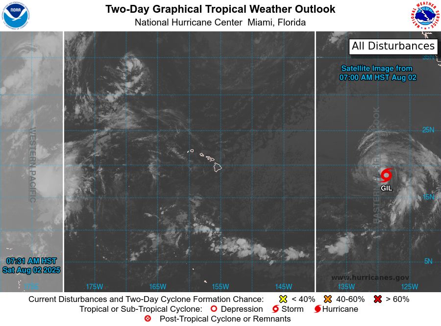
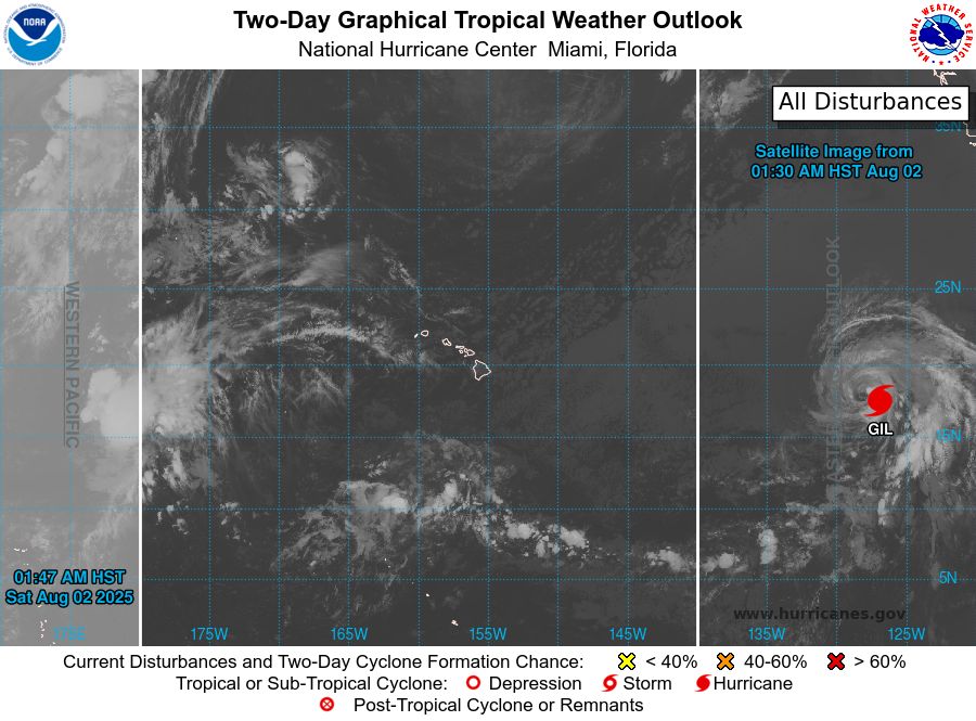
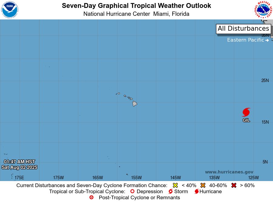
ZCZC HFOTWOCP ALL<br>TTAA00 PHFO DDHHMM<br><br>Tropical Weather Outlook<br>NWS Central Pacific Hurricane Center Honolulu HI<br>Issued by NWS National Hurricane Center Miami FL<br>200 AM HST Sat Aug 02 2025<br><br>For the central North Pacific...between 140W and 180W:<br><br>Active Systems:<br>The National Hurricane Center is issuing advisories on Hurricane<br>Gil, located well west-southwest of the southern Baja California<br>peninsula.<br><br>Tropical cyclone formation is not expected during the next 7 days.<br><br><br>Forecaster Hogsett<br><br><br>
Central North Pacific 2-Day Graphical Outlook Image

Central North Pacific 7-Day Graphical Outlook Image
CPHC Central North Pacific Outlook update for Sat, 02 Aug 2025 14:35:35 UTC
Additional Details Here.
02.08.2025 14:40 — 👍 0 🔁 0 💬 0 📌 0
ZCZC HFOTWOCP ALL<br>TTAA00 PHFO DDHHMM<br><br>Tropical Weather Outlook<br>NWS Central Pacific Hurricane Center Honolulu HI<br>Issued by NWS National Hurricane Center Miami FL<br>200 AM HST Sat Aug 02 2025<br><br>For the central North Pacific...between 140W and 180W:<br><br>Active Systems:<br>The National Hurricane Center is issuing advisories on Hurricane<br>Gil, located well west-southwest of the southern Baja California<br>peninsula.<br><br>Tropical cyclone formation is not expected during the next 7 days.<br><br><br>Forecaster Hogsett<br><br><br>
Central North Pacific 2-Day Graphical Outlook Image
Central North Pacific 7-Day Graphical Outlook Image
CPHC Central North Pacific Outlook update for Sat, 02 Aug 2025 11:47:21 UTC
Additional Details Here.
02.08.2025 11:50 — 👍 0 🔁 0 💬 0 📌 0
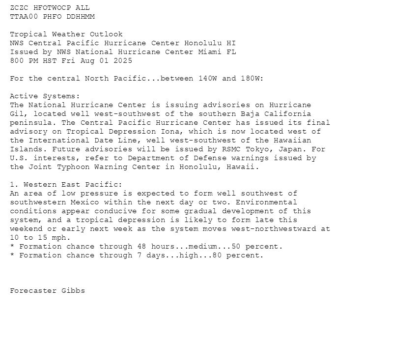
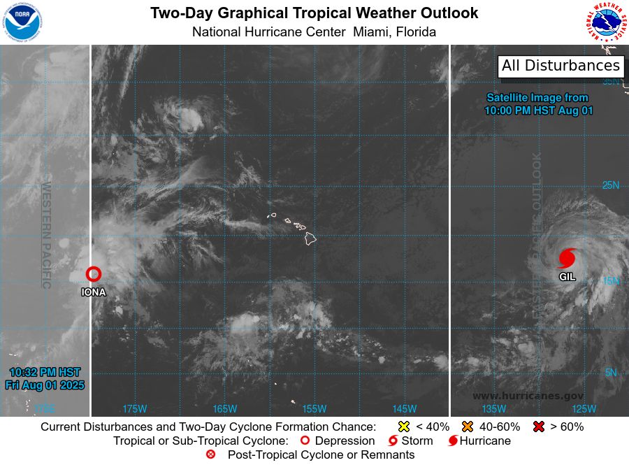
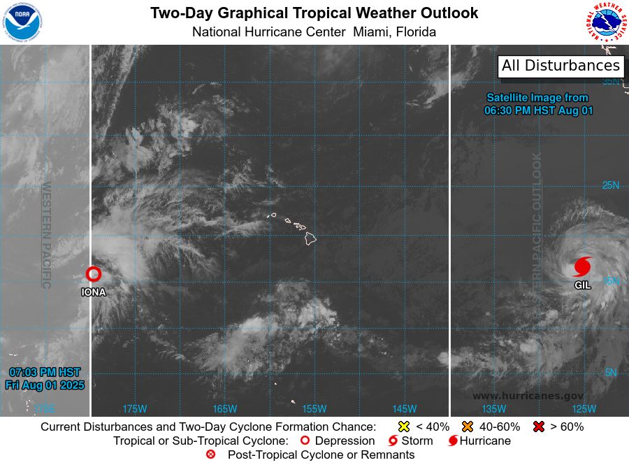
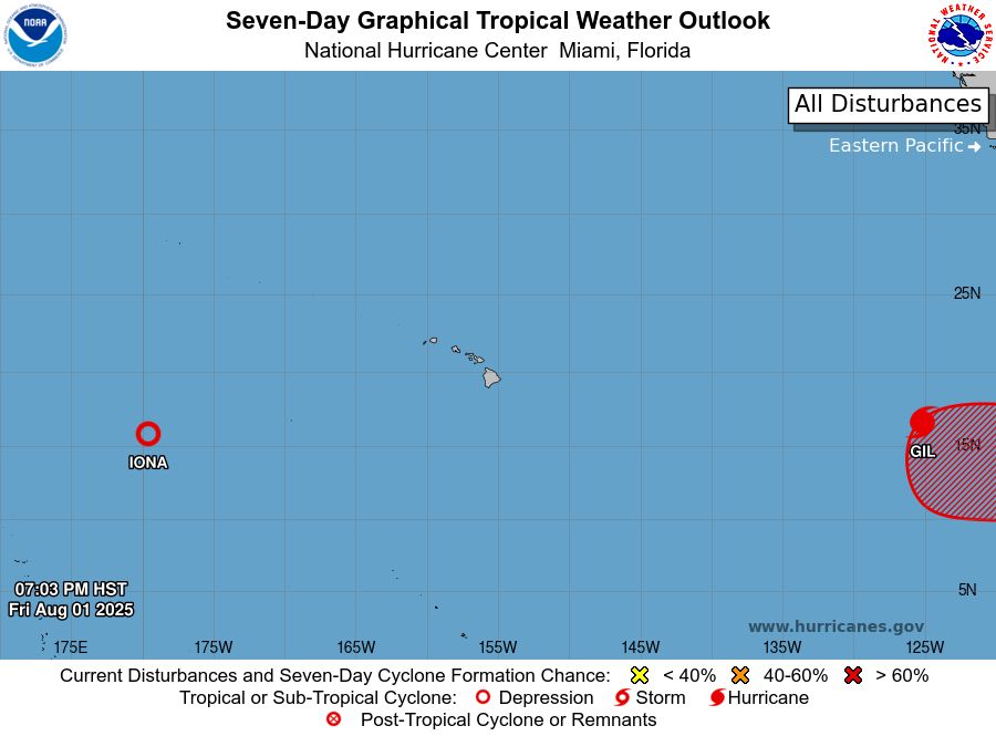
ZCZC HFOTWOCP ALL<br>TTAA00 PHFO DDHHMM<br><br>Tropical Weather Outlook<br>NWS Central Pacific Hurricane Center Honolulu HI<br>Issued by NWS National Hurricane Center Miami FL<br>800 PM HST Fri Aug 01 2025<br><br>For the central North Pacific...between 140W and 180W:<br><br>Active Systems:<br>The National Hurricane Center is issuing advisories on Hurricane<br>Gil, located well west-southwest of the southern Baja California<br>peninsula. The Central Pacific Hurricane Center has issued its final<br>advisory on Tropical Depression Iona, which is now located west of<br>the International Date Line, well west-southwest of the Hawaiian<br>Islands. Future advisories will be issued by RSMC Tokyo, Japan. For<br>U.S. interests, refer to Department of Defense warnings issued by<br>the Joint Typhoon Warning Center in Honolulu, Hawaii.<br><br>1. Western East Pacific:<br>An area of low pressure is expected to form well southwest of<br>southwestern Mexico within the next day or two. Environmental<br>conditions appear conducive for some gradual development of this<br>system, and a tropical depression is likely to form late this<br>weekend or early next week as the system moves west-northwestward at<br>10 to 15 mph.<br>* Formation chance through 48 hours...medium...50 percent.<br>* Formation chance through 7 days...high...80 percent.<br><br><br><br>Forecaster Gibbs<br><br><br>
Central North Pacific 2-Day Graphical Outlook Image

Central North Pacific 7-Day Graphical Outlook Image
CPHC Central North Pacific Outlook update for Sat, 02 Aug 2025 08:32:56 UTC
Additional Details Here.
02.08.2025 08:40 — 👍 0 🔁 0 💬 0 📌 0
ZCZC HFOTWOCP ALL<br>TTAA00 PHFO DDHHMM<br><br>Tropical Weather Outlook<br>NWS Central Pacific Hurricane Center Honolulu HI<br>Issued by NWS National Hurricane Center Miami FL<br>800 PM HST Fri Aug 01 2025<br><br>For the central North Pacific...between 140W and 180W:<br><br>Active Systems:<br>The National Hurricane Center is issuing advisories on Hurricane<br>Gil, located well west-southwest of the southern Baja California<br>peninsula. The Central Pacific Hurricane Center has issued its final<br>advisory on Tropical Depression Iona, which is now located west of<br>the International Date Line, well west-southwest of the Hawaiian<br>Islands. Future advisories will be issued by RSMC Tokyo, Japan. For<br>U.S. interests, refer to Department of Defense warnings issued by<br>the Joint Typhoon Warning Center in Honolulu, Hawaii.<br><br>1. Western East Pacific:<br>An area of low pressure is expected to form well southwest of<br>southwestern Mexico within the next day or two. Environmental<br>conditions appear conducive for some gradual development of this<br>system, and a tropical depression is likely to form late this<br>weekend or early next week as the system moves west-northwestward at<br>10 to 15 mph.<br>* Formation chance through 48 hours...medium...50 percent.<br>* Formation chance through 7 days...high...80 percent.<br><br><br><br>Forecaster Gibbs<br><br><br>
Central North Pacific 2-Day Graphical Outlook Image
Central North Pacific 7-Day Graphical Outlook Image
CPHC Central North Pacific Outlook update for Sat, 02 Aug 2025 05:04:15 UTC
Additional Details Here.
02.08.2025 05:10 — 👍 1 🔁 1 💬 0 📌 0
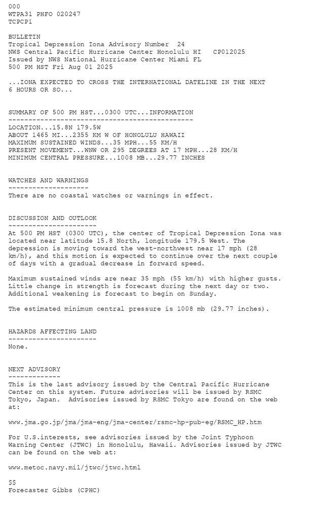
000WTPA31 PHFO 020247TCPCP1 BULLETINTropical Depression Iona Advisory Number 24NWS Central Pacific Hurricane Center Honolulu HI CP012025Issued by NWS National Hurricane Center Miami FL500 PM HST Fri Aug 01 2025 ...IONA EXPECTED TO CROSS THE INTERNATIONAL DATELINE IN THE NEXT6 HOURS OR SO... SUMMARY OF 500 PM HST...0300 UTC...INFORMATION----------------------------------------------LOCATION...15.8N 179.5WABOUT 1465 MI...2355 KM W OF HONOLULU HAWAIIMAXIMUM SUSTAINED WINDS...35 MPH...55 KM/HPRESENT MOVEMENT...WNW OR 295 DEGREES AT 17 MPH...28 KM/HMINIMUM CENTRAL PRESSURE...1008 MB...29.77 INCHES WATCHES AND WARNINGS--------------------There are no coastal watches or warnings in effect. DISCUSSION AND OUTLOOK----------------------At 500 PM HST (0300 UTC), the center of Tropical Depression Iona waslocated near latitude 15.8 North, longitude 179.5 West. Thedepression is moving toward the west-northwest near 17 mph (28 km/h), and this motion is expected to continue over the next couple of days with a gradual decrease in forward speed. Maximum sustained winds are near 35 mph (55 km/h) with higher gusts.Little change in strength is forecast during the next day or two. Additional weakening is forecast to begin on Sunday. The estimated minimum central pressure is 1008 mb (29.77 inches). HAZARDS AFFECTING LAND----------------------None. NEXT ADVISORY-------------This is the last advisory issued by the Central Pacific Hurricane Center on this system. Future advisories will be issued by RSMC Tokyo, Japan. Advisories issued by RSMC Tokyo are found on the web at:www.jma.go.jp/jma/jma-eng/jma-center/rsmc-hp-pub-eg/RSMC_HP.htm For U.S.interests, see advisories issued by the Joint Typhoon Warning Center (JTWC) in Honolulu, Hawaii. Advisories issued by JTWC can be found on the web at: www.metoc.navy.mil/jtwc/jtwc.html $$Forecaster Gibbs (CPHC)
Tropical Depression Iona 5-Day Uncertainty Track Image
Tropical Depression Iona 34-Knot Wind Speed Probabilities
Central North Pacific Tropical Depression Iona Advisory Number 24 issued at Sat, 02 Aug 2025 02:47:28 +0000
...IONA EXPECTED TO CROSS THE INTERNATIONAL DATELINE IN THE NEXT 6 HOURS OR SO...
Additional Details Here.
02.08.2025 02:50 — 👍 1 🔁 1 💬 0 📌 0
ZCZC HFOTWOCP ALL<br>TTAA00 PHFO DDHHMM<br><br>Tropical Weather Outlook<br>NWS Central Pacific Hurricane Center Honolulu HI<br>Issued by NWS National Hurricane Center Miami FL<br>200 PM HST Fri Aug 01 2025<br><br>For the central North Pacific...between 140W and 180W:<br><br>Active Systems:<br>The National Hurricane Center is issuing advisories on Tropical<br>Storm Iona, located in the central Pacific basin well west-southwest<br>of the Hawaiian Islands, and Tropical Storm Gil, located well<br>west-southwest of the southern Baja California peninsula.<br><br>Tropical cyclone formation is not expected during the next 7 days.<br><br><br>Forecaster Gibbs<br><br><br>
Central North Pacific 2-Day Graphical Outlook Image

Central North Pacific 7-Day Graphical Outlook Image
CPHC Central North Pacific Outlook update for Sat, 02 Aug 2025 02:48:50 UTC
Additional Details Here.
02.08.2025 02:50 — 👍 1 🔁 0 💬 0 📌 0
ZCZC HFOTWOCP ALL<br>TTAA00 PHFO DDHHMM<br><br>Tropical Weather Outlook<br>NWS Central Pacific Hurricane Center Honolulu HI<br>Issued by NWS National Hurricane Center Miami FL<br>200 PM HST Fri Aug 01 2025<br><br>For the central North Pacific...between 140W and 180W:<br><br>Active Systems:<br>The National Hurricane Center is issuing advisories on Tropical<br>Storm Iona, located in the central Pacific basin well west-southwest<br>of the Hawaiian Islands, and Tropical Storm Gil, located well<br>west-southwest of the southern Baja California peninsula.<br><br>Tropical cyclone formation is not expected during the next 7 days.<br><br><br>Forecaster Gibbs<br><br><br>
Central North Pacific 2-Day Graphical Outlook Image

Central North Pacific 7-Day Graphical Outlook Image
CPHC Central North Pacific Outlook update for Fri, 01 Aug 2025 23:32:47 UTC
Additional Details Here.
01.08.2025 23:40 — 👍 0 🔁 0 💬 0 📌 0

ZCZC HFOTWOCP ALL<br>TTAA00 PHFO DDHHMM<br><br>Tropical Weather Outlook<br>NWS Central Pacific Hurricane Center Honolulu HI<br>Issued by NWS National Hurricane Center Miami FL<br>800 AM HST Fri Aug 01 2025<br><br>For the central North Pacific...between 140W and 180W:<br><br>Active Systems:<br>The National Hurricane Center is issuing advisories on Tropical<br>Storm Iona, located in the central Pacific basin well west-southwest<br>of the Hawaiian Islands and Tropical Storm Gil, located well<br>west-southwest of the southern Baja California peninsula.<br><br>Tropical cyclone formation is not expected during the next 7 days.<br><br><br>Forecaster Bucci<br><br><br>
Central North Pacific 2-Day Graphical Outlook Image

Central North Pacific 7-Day Graphical Outlook Image
CPHC Central North Pacific Outlook update for Fri, 01 Aug 2025 20:39:40 UTC
Additional Details Here.
01.08.2025 20:50 — 👍 0 🔁 0 💬 0 📌 0
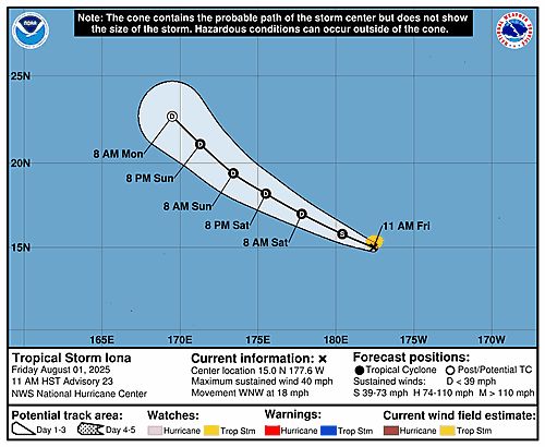
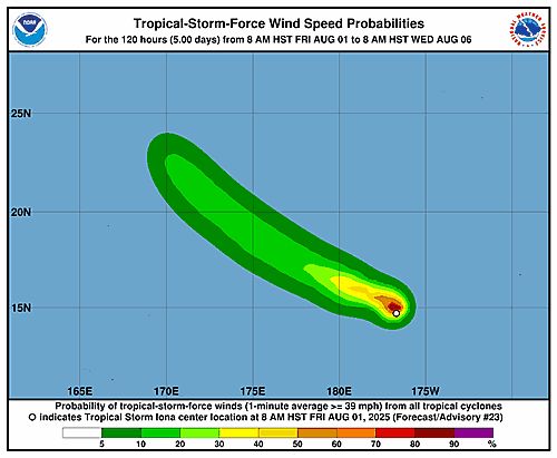
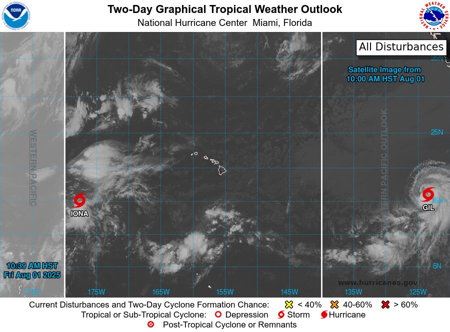
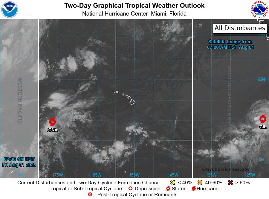
000WTPA31 PHFO 012034TCPCP1 BULLETINTropical Storm Iona Advisory Number 23NWS Central Pacific Hurricane Center Honolulu HI CP012025Issued by NWS National Hurricane Center Miami FL1100 AM HST Fri Aug 01 2025 ...IONA EXPECTED TO CROSS THE INTERNATIONAL DATELINE IN THE NEXT12 HOURS OR SO... SUMMARY OF 1100 AM HST...2100 UTC...INFORMATION-----------------------------------------------LOCATION...15.0N 177.6WABOUT 1360 MI...2195 KM WSW OF HONOLULU HAWAIIMAXIMUM SUSTAINED WINDS...40 MPH...65 KM/HPRESENT MOVEMENT...WNW OR 285 DEGREES AT 18 MPH...30 KM/HMINIMUM CENTRAL PRESSURE...1006 MB...29.71 INCHES WATCHES AND WARNINGS--------------------There are no coastal watches or warnings in effect. DISCUSSION AND OUTLOOK----------------------At 1100 AM HST (2100 UTC), the center of Tropical Storm Iona waslocated near latitude 15.0 North, longitude 177.6 West. Iona ismoving toward the west-northwest near 18 mph (30 km/h), and thismotion is expected to continue over the next couple of days with agradual decrease in forward speed. Maximum sustained winds are near 40 mph (65 km/h) with higher gusts.Gradual weakening is forecast during the next couple of days, andIona is expected to weaken to a depression tonight or on Saturday. Tropical-storm-force winds extend outward up to 60 miles (95 km)from the center. The estimated minimum central pressure is 1006 mb (29.71 inches). HAZARDS AFFECTING LAND----------------------None. NEXT ADVISORY-------------Next complete advisory at 500 PM HST. $$Forecaster Beven
Tropical Storm Iona 5-Day Uncertainty Track Image
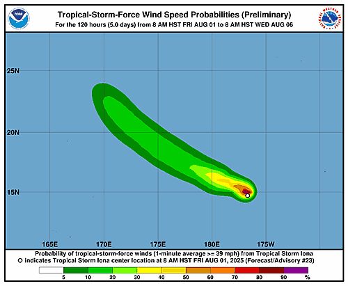
Tropical Storm Iona 34-Knot Wind Speed Probabilities
Central North Pacific Tropical Storm Iona Advisory Number 23 issued at Fri, 01 Aug 2025 20:34:57 +0000
...IONA EXPECTED TO CROSS THE INTERNATIONAL DATELINE IN THE NEXT 12 HOURS OR SO...
Additional Details Here.
01.08.2025 20:40 — 👍 0 🔁 0 💬 0 📌 0
ZCZC HFOTWOCP ALL<br>TTAA00 PHFO DDHHMM<br><br>Tropical Weather Outlook<br>NWS Central Pacific Hurricane Center Honolulu HI<br>Issued by NWS National Hurricane Center Miami FL<br>800 AM HST Fri Aug 01 2025<br><br>For the central North Pacific...between 140W and 180W:<br><br>Active Systems:<br>The National Hurricane Center is issuing advisories on Tropical<br>Storm Iona, located in the central Pacific basin well west-southwest<br>of the Hawaiian Islands and Tropical Storm Gil, located well<br>west-southwest of the southern Baja California peninsula.<br><br>Tropical cyclone formation is not expected during the next 7 days.<br><br><br>Forecaster Bucci<br><br><br>
Central North Pacific 2-Day Graphical Outlook Image
Central North Pacific 7-Day Graphical Outlook Image
CPHC Central North Pacific Outlook update for Fri, 01 Aug 2025 20:38:42 UTC
Additional Details Here.
01.08.2025 20:40 — 👍 0 🔁 0 💬 0 📌 0
ZCZC HFOTWOCP ALL<br>TTAA00 PHFO DDHHMM<br><br>Tropical Weather Outlook<br>NWS Central Pacific Hurricane Center Honolulu HI<br>Issued by NWS National Hurricane Center Miami FL<br>800 AM HST Fri Aug 01 2025<br><br>For the central North Pacific...between 140W and 180W:<br><br>Active Systems:<br>The National Hurricane Center is issuing advisories on Tropical<br>Storm Iona, located in the central Pacific basin well west-southwest<br>of the Hawaiian Islands and Tropical Storm Gil, located well<br>west-southwest of the southern Baja California peninsula.<br><br>Tropical cyclone formation is not expected during the next 7 days.<br><br><br>Forecaster Bucci<br><br><br>
Central North Pacific 2-Day Graphical Outlook Image

Central North Pacific 7-Day Graphical Outlook Image
CPHC Central North Pacific Outlook update for Fri, 01 Aug 2025 17:36:39 UTC
Additional Details Here.
01.08.2025 17:40 — 👍 0 🔁 0 💬 0 📌 0