ALY issues Area Forecast Discussion (AFD) at Aug 7, 7:39 PM EDT
at Thu, 07 Aug 2025 23:40:37 +0000 via IEMbot
Additional Details Here.
07.08.2025 23:47 — 👍 0 🔁 0 💬 0 📌 0
PITTSFIELD MA Aug 7
Climate Report:
High: 77
Low: 61
Precip: 0.13"
Snow: Missing
at Thu, 07 Aug 2025 20:39:49 +0000 via IEMbot
Additional Details Here.
07.08.2025 20:48 — 👍 0 🔁 0 💬 0 📌 0
ALBANY NY Aug 7
Climate Report:
High: 83
Low: 63
Precip: 0.0"
Snow: Missing
at Thu, 07 Aug 2025 20:39:50 +0000 via IEMbot
Additional Details Here.
07.08.2025 20:48 — 👍 0 🔁 0 💬 0 📌 0
ALY issues Area Forecast Discussion (AFD) at Aug 7, 1:54 PM EDT
at Thu, 07 Aug 2025 17:55:05 +0000 via IEMbot
Additional Details Here.
07.08.2025 18:07 — 👍 0 🔁 0 💬 0 📌 0
ALY issues Area Forecast Discussion (AFD) at Aug 7, 6:11 AM EDT
at Thu, 07 Aug 2025 10:11:55 +0000 via IEMbot
Additional Details Here.
07.08.2025 10:27 — 👍 0 🔁 0 💬 0 📌 0
PITTSFIELD MA Aug 6
Climate Report:
High: 77
Low: 62
Precip: 0.43"
Snow: Missing
at Thu, 07 Aug 2025 06:32:10 +0000 via IEMbot
Additional Details Here.
07.08.2025 06:48 — 👍 0 🔁 0 💬 0 📌 0
GLENS FALLS NY Aug 6
Climate Report:
High: 83
Low: 54
Precip: 0.0"
Snow: Missing
at Thu, 07 Aug 2025 06:32:10 +0000 via IEMbot
Additional Details Here.
07.08.2025 06:48 — 👍 0 🔁 0 💬 0 📌 0
ALY issues Area Forecast Discussion (AFD) at Aug 7, 2:38 AM EDT
at Thu, 07 Aug 2025 06:39:36 +0000 via IEMbot
Additional Details Here.
07.08.2025 06:48 — 👍 0 🔁 0 💬 0 📌 0
ALY issues Area Forecast Discussion (AFD) at Aug 7, 1:17 AM EDT
at Thu, 07 Aug 2025 05:17:57 +0000 via IEMbot
Additional Details Here.
07.08.2025 05:27 — 👍 0 🔁 0 💬 0 📌 0
ALY expires Flood Advisory for Hamilton, Warren [NY]
at Thu, 07 Aug 2025 03:28:44 +0000 via IEMbot
Additional Details Here.
07.08.2025 03:47 — 👍 0 🔁 0 💬 0 📌 0
Pittsfield [Berkshire Co, MA] Broadcast Media reports Rain of 1.47 Inch at 6 Aug, 6:07 PM EDT -- WeatherNet6.
at Thu, 07 Aug 2025 01:22:34 +0000 via IEMbot
Additional Details Here.
07.08.2025 01:27 — 👍 0 🔁 0 💬 0 📌 0
Hancock [Berkshire Co, MA] Amateur Radio reports Rain of 1.48 Inch at 6 Aug, 9:15 PM EDT -- Twitter report. Observation from Jiminy Peak Summit.
at Thu, 07 Aug 2025 01:22:35 +0000 via IEMbot
Additional Details Here.
07.08.2025 01:27 — 👍 0 🔁 0 💬 0 📌 0
ALY cancels Flood Advisory for Columbia [NY]
at Thu, 07 Aug 2025 01:01:28 +0000 via IEMbot
Additional Details Here.
07.08.2025 01:07 — 👍 0 🔁 0 💬 0 📌 0
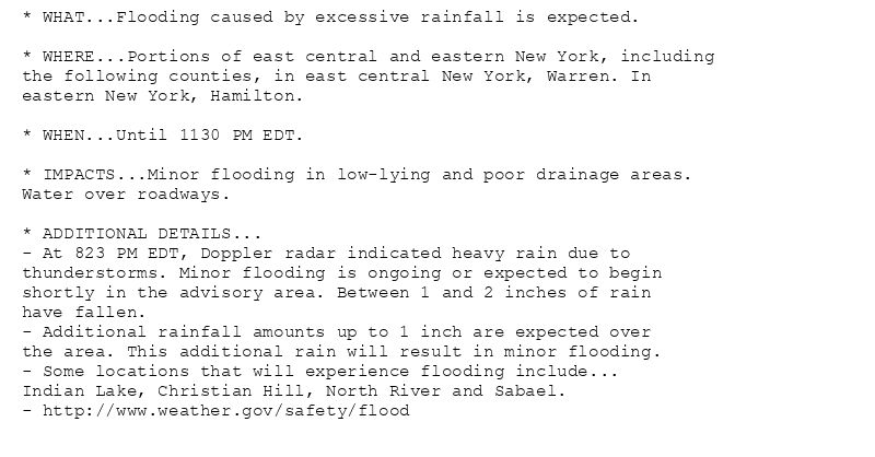
* WHAT...Flooding caused by excessive rainfall is expected.
* WHERE...Portions of east central and eastern New York, including
the following counties, in east central New York, Warren. In
eastern New York, Hamilton.
* WHEN...Until 1130 PM EDT.
* IMPACTS...Minor flooding in low-lying and poor drainage areas.
Water over roadways.
* ADDITIONAL DETAILS...
- At 823 PM EDT, Doppler radar indicated heavy rain due to
thunderstorms. Minor flooding is ongoing or expected to begin
shortly in the advisory area. Between 1 and 2 inches of rain
have fallen.
- Additional rainfall amounts up to 1 inch are expected over
the area. This additional rain will result in minor flooding.
- Some locations that will experience flooding include...
Indian Lake, Christian Hill, North River and Sabael.
- http://www.weather.gov/safety/flood
Flood Advisory issued August 6 at 8:23PM EDT until August 6 at 11:30PM EDT by NWS Albany NY
Additional Details Here.
07.08.2025 00:45 — 👍 0 🔁 0 💬 0 📌 0
ALY issues Flood Advisory for Hamilton, Warren [NY] till Aug 6, 11:30 PM EDT
at Thu, 07 Aug 2025 00:23:55 +0000 via IEMbot
Additional Details Here.
07.08.2025 00:27 — 👍 0 🔁 0 💬 0 📌 0
ALY issues Area Forecast Discussion (AFD) at Aug 6, 7:42 PM EDT
at Wed, 06 Aug 2025 23:42:29 +0000 via IEMbot
Additional Details Here.
06.08.2025 23:47 — 👍 0 🔁 0 💬 0 📌 0
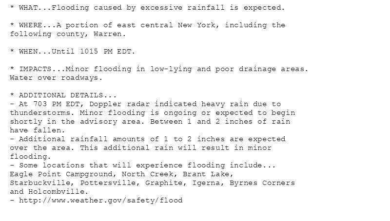
* WHAT...Flooding caused by excessive rainfall is expected.
* WHERE...A portion of east central New York, including the
following county, Warren.
* WHEN...Until 1015 PM EDT.
* IMPACTS...Minor flooding in low-lying and poor drainage areas.
Water over roadways.
* ADDITIONAL DETAILS...
- At 703 PM EDT, Doppler radar indicated heavy rain due to
thunderstorms. Minor flooding is ongoing or expected to begin
shortly in the advisory area. Between 1 and 2 inches of rain
have fallen.
- Additional rainfall amounts of 1 to 2 inches are expected
over the area. This additional rain will result in minor
flooding.
- Some locations that will experience flooding include...
Eagle Point Campground, North Creek, Brant Lake,
Starbuckville, Pottersville, Graphite, Igerna, Byrnes Corners
and Holcombville.
- http://www.weather.gov/safety/flood
Flood Advisory issued August 6 at 7:03PM EDT until August 6 at 10:15PM EDT by NWS Albany NY
Additional Details Here.
06.08.2025 23:15 — 👍 0 🔁 0 💬 0 📌 0
ALY issues A STRONG THUNDERSTORM WILL IMPACT NORTHERN WARREN COUNTY THROUGH 800 PM EDT [wind: 50 MPH, hail: 0.75 IN]
at Wed, 06 Aug 2025 22:54:06 +0000 via IEMbot
Additional Details Here.
06.08.2025 23:07 — 👍 0 🔁 0 💬 0 📌 0
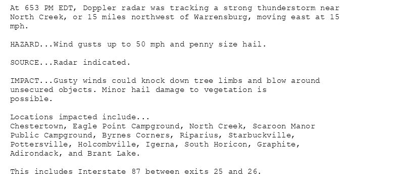
At 653 PM EDT, Doppler radar was tracking a strong thunderstorm near
North Creek, or 15 miles northwest of Warrensburg, moving east at 15
mph.
HAZARD...Wind gusts up to 50 mph and penny size hail.
SOURCE...Radar indicated.
IMPACT...Gusty winds could knock down tree limbs and blow around
unsecured objects. Minor hail damage to vegetation is
possible.
Locations impacted include...
Chestertown, Eagle Point Campground, North Creek, Scaroon Manor
Public Campground, Byrnes Corners, Riparius, Starbuckville,
Pottersville, Holcombville, Igerna, South Horicon, Graphite,
Adirondack, and Brant Lake.
This includes Interstate 87 between exits 25 and 26.
Special Weather Statement issued August 6 at 6:53PM EDT by NWS Albany NY
Additional Details Here.
06.08.2025 23:00 — 👍 0 🔁 0 💬 0 📌 0
ALY issues STRONG THUNDERSTORMS WILL IMPACT NORTHEASTERN WARREN COUNTY THROUGH 700 PM EDT [wind: 40 MPH, hail: 0.75 IN] for Northern Warren [NY]
at Wed, 06 Aug 2025 22:36:08 +0000 via IEMbot
Additional Details Here.
06.08.2025 22:47 — 👍 0 🔁 0 💬 0 📌 0
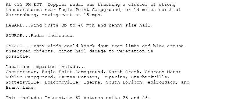
At 635 PM EDT, Doppler radar was tracking a cluster of strong
thunderstorms near Eagle Point Campground, or 14 miles north of
Warrensburg, moving east at 15 mph.
HAZARD...Wind gusts up to 40 mph and penny size hail.
SOURCE...Radar indicated.
IMPACT...Gusty winds could knock down tree limbs and blow around
unsecured objects. Minor hail damage to vegetation is
possible.
Locations impacted include...
Chestertown, Eagle Point Campground, North Creek, Scaroon Manor
Public Campground, Byrnes Corners, Riparius, Starbuckville,
Pottersville, Holcombville, Igerna, South Horicon, Adirondack, and
Brant Lake.
This includes Interstate 87 between exits 25 and 26.
Special Weather Statement issued August 6 at 6:36PM EDT by NWS Albany NY
Additional Details Here.
06.08.2025 22:45 — 👍 0 🔁 0 💬 0 📌 0
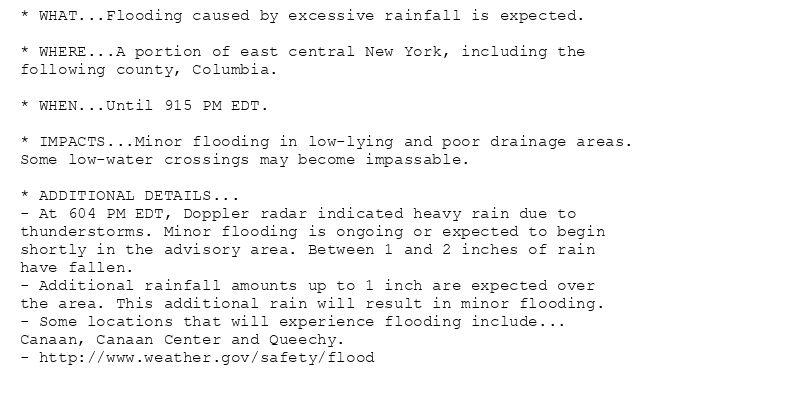
* WHAT...Flooding caused by excessive rainfall is expected.
* WHERE...A portion of east central New York, including the
following county, Columbia.
* WHEN...Until 915 PM EDT.
* IMPACTS...Minor flooding in low-lying and poor drainage areas.
Some low-water crossings may become impassable.
* ADDITIONAL DETAILS...
- At 604 PM EDT, Doppler radar indicated heavy rain due to
thunderstorms. Minor flooding is ongoing or expected to begin
shortly in the advisory area. Between 1 and 2 inches of rain
have fallen.
- Additional rainfall amounts up to 1 inch are expected over
the area. This additional rain will result in minor flooding.
- Some locations that will experience flooding include...
Canaan, Canaan Center and Queechy.
- http://www.weather.gov/safety/flood
Flood Advisory issued August 6 at 6:04PM EDT until August 6 at 9:15PM EDT by NWS Albany NY
Additional Details Here.
06.08.2025 22:15 — 👍 0 🔁 0 💬 0 📌 0
ALY issues Flood Advisory for Columbia [NY] till Aug 6, 9:15 PM EDT
at Wed, 06 Aug 2025 22:04:50 +0000 via IEMbot
Additional Details Here.
06.08.2025 22:07 — 👍 0 🔁 0 💬 0 📌 0
BENNINGTON VT Aug 6
Climate Report:
High: None
Low: None
Precip: Missing
Snow: Missing
at Wed, 06 Aug 2025 20:37:20 +0000 via IEMbot
Additional Details Here.
06.08.2025 20:48 — 👍 0 🔁 0 💬 0 📌 0
POUGHKEEPSIE NY Aug 6
Climate Report:
High: 79
Low: 62
Precip: 0.0"
Snow: Missing
at Wed, 06 Aug 2025 20:37:22 +0000 via IEMbot
Additional Details Here.
06.08.2025 20:48 — 👍 0 🔁 0 💬 0 📌 0
ALY issues A STRONG THUNDERSTORM WILL IMPACT NORTH CENTRAL BERKSHIRE COUNTY THROUGH 300 PM EDT [wind: 40 MPH, hail: 0.75 IN] for Northern Berkshire [MA]
at Wed, 06 Aug 2025 18:31:45 +0000 via IEMbot
Additional Details Here.
06.08.2025 18:47 — 👍 0 🔁 0 💬 0 📌 0
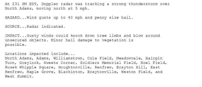
At 231 PM EDT, Doppler radar was tracking a strong thunderstorm over
North Adams, moving north at 5 mph.
HAZARD...Wind gusts up to 40 mph and penny size hail.
SOURCE...Radar indicated.
IMPACT...Gusty winds could knock down tree limbs and blow around
unsecured objects. Minor hail damage to vegetation is
possible.
Locations impacted include...
North Adams, Adams, Williamstown, Cole Field, Meadowvale, Hairpin
Turn, Greylock, Sweets Corner, Soldiers Memorial Field, Noel Field,
Rusek Whipple Square, Houghtonville, Renfrew, Brayton Hill, East
Renfrew, Maple Grove, Blackinton, Braytonville, Weston Field, and
West Summit.
Special Weather Statement issued August 6 at 2:31PM EDT by NWS Albany NY
Additional Details Here.
06.08.2025 18:45 — 👍 0 🔁 0 💬 0 📌 0
ALY issues Area Forecast Discussion (AFD) at Aug 6, 1:21 PM EDT
at Wed, 06 Aug 2025 17:21:53 +0000 via IEMbot
Additional Details Here.
06.08.2025 17:27 — 👍 0 🔁 0 💬 0 📌 0
ALY issues Area Forecast Discussion (AFD) at Aug 6, 6:28 AM EDT
at Wed, 06 Aug 2025 10:28:30 +0000 via IEMbot
Additional Details Here.
06.08.2025 10:47 — 👍 0 🔁 0 💬 0 📌 0
ALY issues Area Forecast Discussion (AFD) at Aug 6, 3:03 AM EDT
at Wed, 06 Aug 2025 07:04:15 +0000 via IEMbot
Additional Details Here.
06.08.2025 07:08 — 👍 0 🔁 0 💬 0 📌 0