Discover how #lidar reveals the size & location of individual Ponderosa Pines at Sunset Crater, AZ! Using advanced algorithms in lidR, we map tree height and crowns in stunning detail, informing forest ecology and management.
openforest4d.org/tree-identif...
#Forestry
#RemoteSensing
#RStats
30.10.2025 15:41 — 👍 8 🔁 3 💬 1 📌 0

A lidar point cloud along central California’s Big Sur coast displaying elevation, classification, return number, and intensity. The airborne lidar point cloud was collected in 2022 has a point density of 85 points/m2.
Ever wondered what #lidar point clouds reveal about forests? OpenForest4D’s new guide breaks down how elevation, return number, intensity, and classification describe forest structure.
openforest4d.org/lidar-point-...
#pointcloud #laserscanning #forestry #geospatial
27.10.2025 16:33 — 👍 10 🔁 4 💬 1 📌 0

Graphic with a colorful rainbow river relative elevation model at the bottom and text on top reading "OpenTopography. GSA Connects 2025 | Oct. 19-22"
OT will be at GSA Connects 2025 in San Antonio, TX, Oct 19–22. Visit us at booth 809 to talk lidar, topography, and grab an "I ❤️ LIDAR" sticker. OT is honored to receive the 2025 GSA President’s Medal. Join us for the President’s Medal Lecture on Mon Oct. 20.
opentopography.org/news/opentop...
15.10.2025 15:32 — 👍 2 🔁 1 💬 0 📌 0

NIH, NASA, NSF budget cuts, FY 2026 - catastrophic.
https://joshuasweitz.substack.com/p/the-white-house-vision-for-dismantling
The White House Vision for Dismantling Science in One Simple Plot
(Proposed NIH, NSF, and NASA budgets would be catastrophic for innovation and discovery. But they aren’t reality yet. The time to speak up is now.)
joshuasweitz.substack.com/p/the-white-...
31.05.2025 14:38 — 👍 104 🔁 30 💬 2 📌 6
Effective immediately, the PGC is no longer accepting new NSF-supported requests due to a lack of renewal funding. Current work is wrapping up. Please contact your NSF program officer if impacted. We’re grateful to have supported your polar research. Read our full statement at www.pgc.umn.edu
05.05.2025 21:33 — 👍 71 🔁 31 💬 2 📌 13

Digital surface models of the mountainous topography surrounding a suburban development Phoenix, Arizona.

A lidar point cloud of a wind farm in Minnesota colored by intensity.

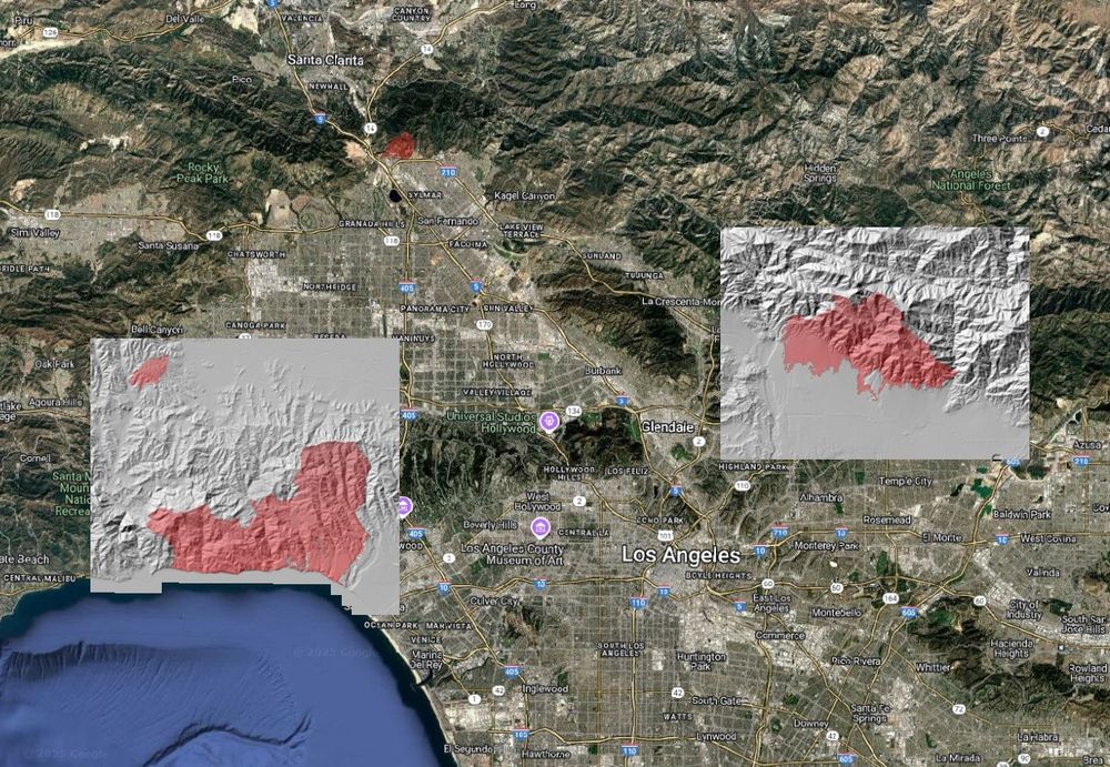
Topographic differencing map of Central Altadena, Los Angeles County, after the January 2025 fires.
Lidar is reshaping how utilities plan, build, and protect infrastructure. From optimizing wind and solar farms to assessing wildfire risks, high resolution topography is critical for developing more resilient infrastructure.
Read more about lidar and utilities: opentopography.org/blog/utility...
28.04.2025 20:13 — 👍 3 🔁 3 💬 1 📌 0
Why do humans face so many health challenges? Discover the answers at our virtual symposium, “Mismatch: Human Origins and Modern Disease”! 👣🚑
Date: Friday, May 16, 2025
Time: 10:00 AM – 2:30 PM (Pacific Time)
Register & Watch Live: carta.anthropogeny.org
26.03.2025 18:05 — 👍 1 🔁 1 💬 0 📌 0

Flyer summarizing webinar series of events: March 5, 2025 Introduction to OpenTopography; March 12, 2025 Introduction to point clouds; March 19, 2025 Introduction to Digital Elevation Models; March 26, 2025 Introduction to topographic differencing.
Join us for the FREE OpenTopography Spring Webinar Series. Four weekly hour-long webinars starting March 5th. We'll provide an overview of OpenTopography, high resolution topography (#lidar), and OpenTopography's processing tools. Registration & more information: opentopography.org/news/2025-we...
26.02.2025 15:11 — 👍 7 🔁 7 💬 0 📌 0
It is time for all of our societies to speak up about this attack on US science.
Speak now, please!
@agu.org
@nationalacademies.org
@igsoc.bsky.social
18.02.2025 20:50 — 👍 16 🔁 8 💬 1 📌 0
Incompetence in Washington puts every American at risk, no matter how you voted. No one should be happy that the DOGE team - the same folks who randomly published classified U.S. security information online today - wants access to your bank account & Social Security numbers.
15.02.2025 03:26 — 👍 98476 🔁 26238 💬 2576 📌 950

Map for lidar-derived change from the Palisades Fire for La Costa Beach. Map colored red to blue to show change, overlain on a post-fire digital surface model hillshade.

Impacts on vegetation in Topanga State Park. Map colored red to blue to show areas of change. Overlain on a post-fire digital surface model hillshade.
Using #lidar to understand the impacts of the 2025 Palisades and Eaton Fires, Los Angeles, CA: We processed pre- & post- fire lidar data to illustrate the changes to the natural and built environments caused by these devastating fires. Blog for more info & images: opentopography.org/blog/using-l...
11.02.2025 15:55 — 👍 8 🔁 6 💬 2 📌 1
Map of downloadable pre-fire USGS 1 m lidar digital terrain models (DTM) covering the areas impacted by the Palisades and Eaton fires. Fire footprints are as of January 14.
In response to the devastating Los Angeles wildfires, @opentopography.bsky.social is opening its discovery and processing services on pre-wildfire high resolution topography lidar data for Los Angeles County. opentopography.org/news/2025_LA...
14.01.2025 22:35 — 👍 1 🔁 0 💬 0 📌 0

OpenTopography "I heart lidar" bumper sticker.
OT will be at #AGU24 next week. Visit us in booth #1108 in the exhibit hall. Our booth is staffed by the OT team. Stop by & ask questions, provide feedback, and see what's new in OT. We'll also have "I ❤️ #LIDAR" stickers!
More info on the OT booth, talks, posters: opentopography.org/news/opentop...
06.12.2024 15:21 — 👍 8 🔁 2 💬 2 📌 0
AGI represents and serves the #geoscience community by providing collaborative leadership and information to connect Earth, science, and people.
Advancing the monitoring and management of global forest ecosystems. The NSF funded OpenForest4D project is a joint collaboration between UC San Diego, University of Florida and Arizona State University.
www.openforest4d.org
Wandering and sometimes lost.
Earth scientist, professor, mom, living with disability, animal lover, amateur gardener, advocate for fixing lack of D.E.I. in science and academia. Only my thoughts
Transforming the science of cascading geohazards to enable a resilient society.
Explore more on our website: https://www.geoclash.org/
We explore the very foundations of life for the benefit of all. Our team of world-class, award-winning scientists pushes the boundaries of knowledge in research areas including aging, cancer and immunology to diabetes, and brain science.
The AI community building the future!
Find STAC Catalogs, APIs, Learning Resources, Software and Tools.
https://stacindex.org
Maintained by @m-mohr.bsky.social
We believe that avoiding devastating wildfires requires urgent, innovative, and collaborative solutions. Our mission is to bring people together to break down the barriers that currently exist between wildfire-related data, models, and tools.
Tech Lead @developmentseed
Formerly @NASA
Lecturer @ Loyola Marymount University
Founding Editorial Board Member @ Cloud-Native Geospatial
Steering Council Member @ Pangeo
open source enthusiast, ultra runner
Advanced Cyberinfrastructure Coordination Ecosystem: Services & Support
Funded by the U.S. National Science Foundation | http://access-ci.org/
The Texas Advanced Computing Center (TACC) at UT Austin designs and deploys powerful computing technologies to power discoveries that change the world. https://tacc.utexas.edu/
Open source, open science, AI in science for earth/ice and healthcare. IPython creator, @projectjupyter.bsky.social and 2i2c.org co-founder.
Prof @ UC Berkeley Stats, director of @ucbids.bsky.social, co-director @schmidtdse.bsky.social; LBL scientist.
Data...Earth, space, ocean, and environmental science. Helping our communities improve their data, software, and digital management practices. Puppy Mom.
https://data.agu.org https://www.agu.org/open-science
The Consortium of Universities for the Advancement of Hydrologic Science, Inc. (CUAHSI)'s mission is to empower the water community and advance science through collaboration, infrastructure, and education.
Hydrologist, Civil Engineer, Teacher, Professor, Runner, Skier, Husband and Father
The Polar Geospatial Center (PGC) at the University of Minnesota provides geospatial support, mapping, and GIS/remote sensing solutions to researchers and logistics groups in the polar science community.
Chief Scientist @ NCSA, Res. Prof. @ CS & iSchool, @ U Illinois Urbana-Champaign
He/him
Works on: computational & data science: software opensource systems tools policy practices scholcomm FAIR RSE
more active on: @danielskatz@fediscience.org
The Geological Society of America (GSA) unites a diverse community of geoscientists in a common purpose to study the mysteries of our planet (and beyond) and share scientific findings.