DGPT Idlewild profiles have some odd errors. But the two that have me scratching my head are 18 and 5 FPO where the elevation tee to basket is reversed.
@discgolfnetwork.bsky.social @perksofdiscgolf.bsky.social

@coursemaps.bsky.social
cartographer, disc golfer, PDGA #15699 https://customcoursemaps.com/
DGPT Idlewild profiles have some odd errors. But the two that have me scratching my head are 18 and 5 FPO where the elevation tee to basket is reversed.
@discgolfnetwork.bsky.social @perksofdiscgolf.bsky.social

Glad to see elevation profiles in the DGPT caddie books but they are over simplified to the point of making what is hard to depict on video even more confusing...
1) The slope does not flatten out at the basket and gets steeper right behind.
4) The terrain climbs up after crossing the second pond.
I have an open reel tape that's 300ft and it's useful but its not going to help with elevation or making sure the any map they create is to scale.
Not sure where the DGPT error came from but if they measured with udisc on a mobile device under those power lines that could have caused a problem.

It's actually less than 1% The elevation changes look big but they are a small part of the total length of the hole. Hole 4 is 855ft with a -36 foot drop to the pin. Here is a graphic with the calculations.
21.04.2025 03:09 — 👍 0 🔁 0 💬 1 📌 0Adding to this issue, during the FPO round today Dixon Jowers gave distances to a tiny tree on the fairway as 340ft to the tee and 510ft to the basket which adds to 850ft and no one caught it during the broadcast. Maybe during MPO...
19.04.2025 20:20 — 👍 1 🔁 0 💬 1 📌 0
Not sure how DGPT came up with 939 feet
Hole 4 Bad Rock Creek - 855 feet
Three measurements...
#discgolf

I make lots of maps remotely and use multiple sources to collect data. The pro tour rarely includes elevation info. This is what I measured for Bad Rock Creek.
#discgolf

A few elevation profiles at Bad Rock Creek. Home of the Kansas City Wide Open
#discgolf

Eagles Crossing is a course with all the amenities. The tee signs however don't include any elevation information which can easily be displayed along with other information when using geo-referenced imagery.
#discgolf
If you need some analysis in the future for a certain hole let me know!
31.03.2025 21:12 — 👍 1 🔁 0 💬 0 📌 0
A full map drawn to scale with elevation profile and distances.

Elevation profile of the approach to the green.

Terrain map around 18's green showing the old tanks (ponds) that can flood in heavy rain.
Hole 18, Sprinkle Valley from the MVP Open at Austin.
1) A full map drawn to scale with elevation profile and distances.
2) Elevation profile of the approach to the green.
3) Terrain map around 18's green showing the old tanks (ponds) that can flood in heavy rain.
I didn't catch this video podcast when it aired last summer but I'm glad I ran across it...ringing endorsement indeed 😎
#discgolf #cartography #maps
I can get behind pissing if adobe!!
19.01.2025 23:52 — 👍 0 🔁 0 💬 0 📌 0I need to make a proper map of #12 and line them up side by side.
07.01.2025 06:43 — 👍 2 🔁 0 💬 0 📌 0Some make me wonder...
They get lazy and don't update after a redesign. Remember Kevin Jones' ace when he fell at #16 Maple Hill during OTB Skins? It was 530' the year before. Basket was moved closer to make room for a new MPO tee on #17. The ace was 460'. Still an amazing hit, but wrong distance.

A sample of how DGPT maps could benefit from greater detail. Using GIS data assures the map is drawn to scale. Compare the shape and size of the main fairway and putting green. (BTW, C2 line is NOT completely OB 🫢)
More samples here: customcoursemaps.com/dgpt-venue-s...
Always rewarding to chat with a team of disc golfers (hosts and producer) that really 'get' what you are trying to accomplish.😎
07.01.2025 04:29 — 👍 6 🔁 2 💬 1 📌 0Full body deep tissue massage. Do it twice a few weeks apart then go back for the trouble spots/locations. My best tournament scores were a few days after a full body massage. I’m not talking spa stuff with nice smells a steam cloths…this is serious moving muscle tissue.
27.12.2024 19:33 — 👍 2 🔁 0 💬 1 📌 0Appreciate the love! Would like to nerd out about these maps on the show. The disc golf world is sleeping on the amazing amount detail that could be utilized in the sport...
12.12.2024 13:48 — 👍 2 🔁 0 💬 0 📌 0
Elevation tells a story. It can easily complicate an already tough fairway. The first landing area from the tee presents a problem when calculating your next move since that laser range finder won't help as the target is around the corner and over the hill.
Elevation tells a story and complicates an already tough fairway. The second shot has to navigate the OB and woods and your rangefinder won't help with the target around the corner and over the hill.
@randisc.com
@bagelpowered.bsky.social
@greensplatter.bsky.social
@hangingloosepod.bsky.social
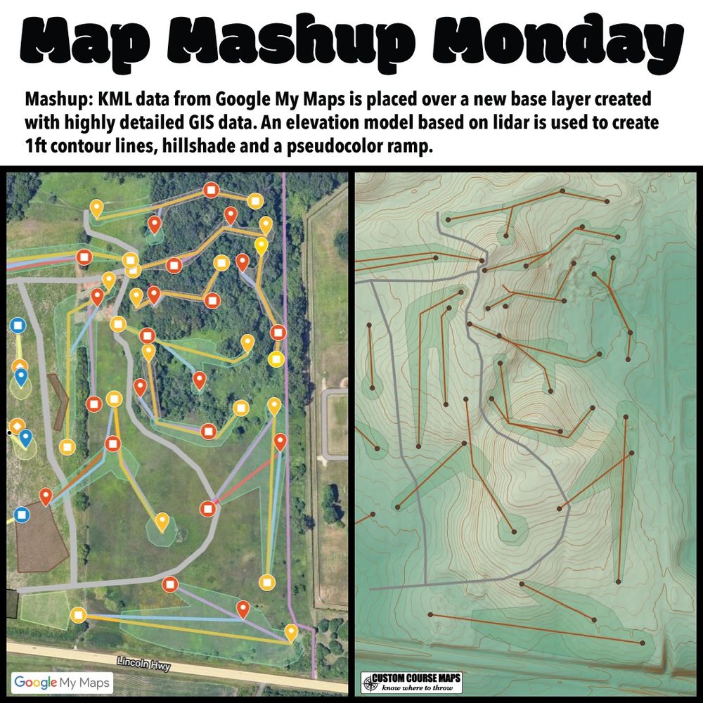
Side by side images of part of a disc golf course. I was sent this disc golf course mockup by a designer wanting a cost estimate for signage. My first step is to look at the elevation of the property. KML data imports easily into GIS software making a mashup like this rather simple.
I was sent this disc golf course mockup by a designer wanting a cost estimate for signage. My first step is to look at the elevation of the property. KML data imports easily into GIS software making a mashup like this rather simple.
customcoursemaps.com

Elevation base layers make a huge difference for disc golf maps. Here is a breakdown of how that layer is created. this image has fours views derived from an elevation model.
Elevation base layers make a huge difference for disc golf maps. Here is a breakdown of how that layer is created.
see more: customcoursemaps.com

Image of a map mashup adding contour lines, hillshade and a pseudocolor ramp to the base layer of the 2023 Jonesboro Open course map showing the Disc Side of Heaven Disc Golf Course.
Disc Golf Pro Tour maps and tee signs use a flat base layer. Not sure if this omission is intentional since the announcers always mention how the camera doesn't really show the steepness of the fairway. Maybe they don't know how to include it since it requires some processing. Check out this mashup.
03.12.2024 01:20 — 👍 4 🔁 0 💬 0 📌 0Sweet putt!!
26.11.2024 19:01 — 👍 1 🔁 0 💬 0 📌 0
Elevation data is great way to create base layers with precise scale and detail. The shorelines and small hills are accurately represented. This data also allows elevation profiles to be easily rendered.
customcoursemaps.com/tee-signs/
I made a sample tee sign of the 'Wedding Cake' hole (now #18) to show how crazy the route is with two water crossings.
26.11.2024 17:19 — 👍 1 🔁 0 💬 1 📌 0Thanks for the repost :)
24.11.2024 14:17 — 👍 1 🔁 0 💬 0 📌 0
Tee signs with a tactical feel. Details matter!
• Full size map. (not placed in a small box)
• Elevation change tee to pin.
• 1ft contour lines.
• Down Range distance.
• Elevation Profile.
see more: customcoursemaps.com
Thanks for the repost. If you ever want to chat about detailed disc golf maps on the pod I’m game!
20.11.2024 18:22 — 👍 1 🔁 0 💬 1 📌 0
This disc golf tee sign is from a recent project in a Twin Cities suburb in Minnesota. Details matter!
This disc golf tee sign is from a recent project in a Twin Cities suburb in Minnesota. Details matter!
See more: customcoursemaps.com/minnesota/mn...
@hangingloosepod.bsky.social @frolfermagazine.bsky.social @glowlabsdg.bsky.social