Details | Working at Bristol | University of Bristol
We are looking for a new researcher @UoBEarthSciences ! (36 months funded) if you like 🌋, are good at analysing. 🪨 and enjoy working in large collaborations. Then come and join us! This post is an important part of a new UK NERC funded Large Grant..
www.bristol.ac.uk/jobs/find/de...
19.06.2025 11:02 — 👍 23 🔁 15 💬 1 📌 1
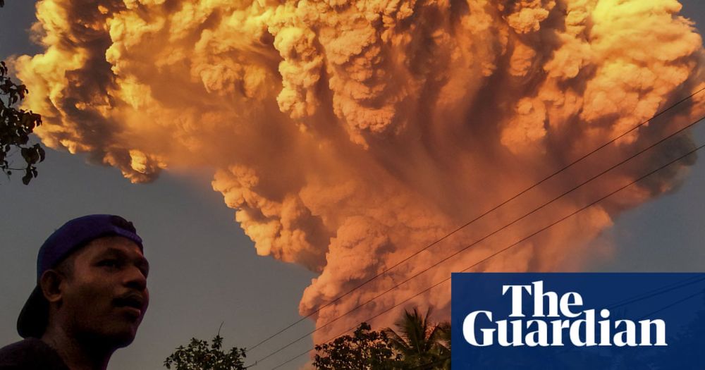
Bali flights cancelled after Indonesian volcano spews 10km-high ash tower
Mount Lewotobi Laki-Laki on the island of Flores, east of Bali, erupted on Tuesday afternoon, leading to several airlines cancelling flights
On 17-18th June, explosive eruptions at Mt. Lewotobi Laki-Laki on the Indonesian island of Flores sent ash >11.5km above sea level. This highlights volcanic hazards on varying scales; pyroclastic flows & lahars threatening local communities, & ash leading to flight cancellations & delays.
19.06.2025 10:20 — 👍 7 🔁 2 💬 1 📌 0
Careers | National Oceanography Centre
We’re hiring! Come and work wit @mikeaclare.bsky.social and me at @noc.ac.uk. We’re recruiting for an open-ended position in marine geohazards.
careers.noc.ac.uk/vacancy/rese...
02.06.2025 08:40 — 👍 7 🔁 7 💬 0 📌 1
We hope that our findings will help inform hazard assessment in valleys affected by similar regimes of eruptive sediment supply!
#volcano #eruption #lahars #fluvial #newresearch
09.05.2025 14:33 — 👍 1 🔁 0 💬 0 📌 0

Figure showing a conceptual diagram of sediment yield and channel response for varying volcanic sediment supply regimes.
We suggest that episodic volcanic eruptions induce patterns of fluvial disturbance and response that share similarities with those generated by better-studied large eruptions (e.g., Pinatubo) and persistent volcanic sediment supply (e.g., Semeru), but that their cyclic nature makes them distinct.
09.05.2025 14:33 — 👍 1 🔁 0 💬 1 📌 0

Figure showing a conceptual diagram relating sediment supply, vegetation cover, and water supply to degrees of aggradation and degradation in the channel.
This synthesis has allowed us to develop a conceptual model relating variable catchment conditions to evolving lahar hazard and channel morphology. We identify a dynamic interplay between sediment supply, water supply, and vegetation cover that exerts control on lahars and channel change.
09.05.2025 14:33 — 👍 0 🔁 0 💬 1 📌 0

Figure showing the changes to vegetation cover over the Belham River catchment between 2001 and 2014
We have measured this channel evolution and the changing state of the catchment by synthesising a multi-parameter dataset derived from a range of sources, including remote sensing (e.g., rainfall, vegetation), topographic data, aerial/ground surveys, volcano observatory logs, and literature.
09.05.2025 14:33 — 👍 0 🔁 0 💬 1 📌 0

Figure showing a) the mean elevation change measured at different transects across the channel between 1995-2019, b) the Belham River at its highest degree of aggradation in 2011, c) a schematic of a two storey house in the valley which has been progressively buried by lahars, showing the burial depths at various dates, d) the same house in 2003 with lahar deposits reaching the base of the walls, e) the same house in 2007 with lahar deposits reaching halfway up the second storey.

Figure showing a) coast profiles at the Belham River mouth between 1995 and 2019, b) an aerial photograph of the Belham River Valley mouth taken in April 1995 by David Watters, c) an aerial photograph of the Belham River Valley mouth taken in 2010 by Henry Odbert.
In this paper we have documented the morphodynamic evolution of the Belham River Valley driven by lahars in response to the episodic eruption of Soufrière Hills Volcano, Montserrat, since 1995.
Generally, the channel has aggraded - minor degradational phases have occurred during eruptive pauses.
09.05.2025 14:33 — 👍 1 🔁 0 💬 1 📌 0
🚨NEW PAPER ALERT🚨
It is *such a pleasure* to announce the publication of a major portion of my PhD thesis with @volcanojenni.bsky.social, @drgeorgieb.bsky.social @tomchudley.bsky.social, Ricky Herd, and Mel Froude in @geomorphica.bsky.social !
Have a read: journals.psu.edu/geomorphica/...
09.05.2025 14:33 — 👍 7 🔁 3 💬 1 📌 0
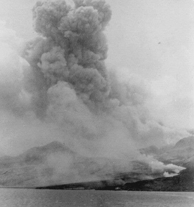
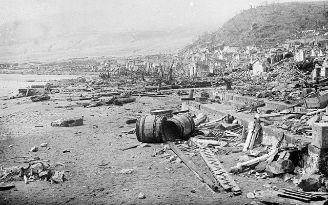
8th May is the anniversary of the 1902 eruption of Mt Pelee, Martinique, which led to the loss of over 28,000 people in the town of St Pierre. The eruption remains one of the most deadly historical eruptions to date & shows the importance of focused preparedness and early action ahead of crises.
08.05.2025 13:59 — 👍 19 🔁 9 💬 1 📌 1
Are you able to share an explanation of the apparent motion amplification along a N/NW - S/SE axis near LA?
17.04.2025 09:12 — 👍 1 🔁 0 💬 0 📌 0
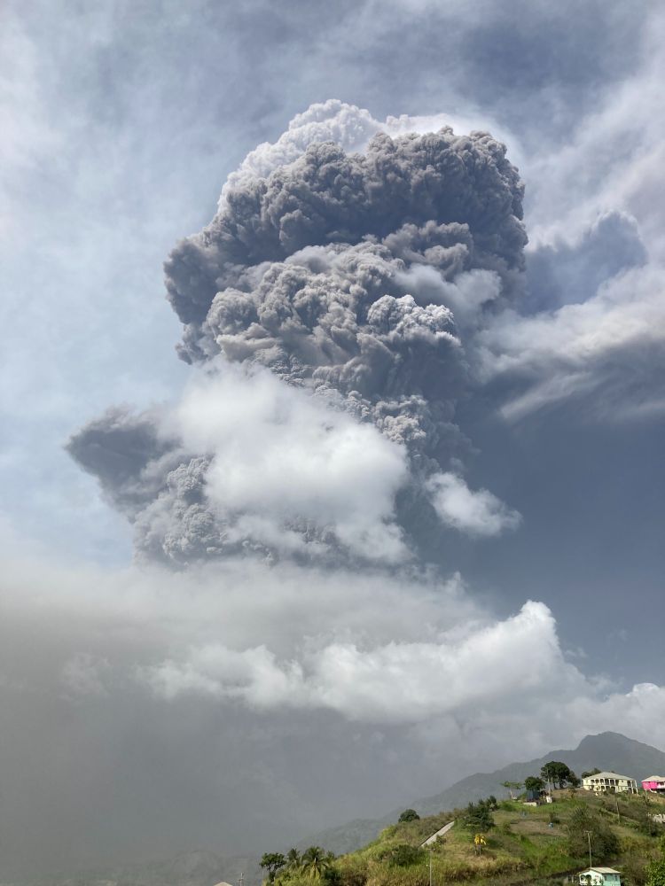
Today marks the 4th anniversary of the explosive phase of the 2020-2021 St Vincent eruption. Effective monitoring, good coordination, extensive education campaigns and efficient communications contributed to the successful evacuation of over 20,000 people with no recorded deaths.
09.04.2025 14:20 — 👍 9 🔁 4 💬 1 📌 1
The Mapping and Geographic Information Centre (MAGIC) provides geospatial information, expertise, and services to the British Antarctic Survey (@bas.ac.uk) and wider UK activity in the Polar Regions.
Cybersecurity Reporter at Recorded Future News. Ex at The Kyiv Independent/Forbes/The Kyiv Post
📍Kyiv, Ukraine
🎨 Illustrator // Volcanologist
📍 Durham University
🧬 Freelance illustrator for Nature journals
🔗 linktr.ee/annabellefoster
Postdoc at Swansea University researching Japanese Tephra.
PhD investigated volcanism in Afar, Ethiopia 🌋🇪🇹
Dysgwr o Gymru
The Volcanology Research Group within University of Bristol, Dept of Earth Sciences.
Showcasing research highlights, achievements, and news from our group and the world of volcanology.
https://www.bristol.ac.uk/earthsciences/research/volcanology/
Applying InSAR to landslides and other stuff at the Geological Survey of Norway (NGU). Opinions here are my own, not necessarily my employer's.
We're a global development charity, building sustainable lives and livelihoods on the frontlines of poverty and climate change.
practicalaction.org
dabbling with photogrammetry, astrophotography, GIS and more...
https://sschmaus.github.io/links/
International Hydrology and Water Resources | Elevation models | Mapping | Landscape, Groundwater and Ecohydrological Systems Analyses
Volcanology, outreach/science communication, inclusivity in STEM, creatives in STEM, politics.
PDRA at the University of Manchester
Views my own.
https://linktr.ee/bdaviesgeo
Assiduous dendroglaciologist, moraine lover, wandering geomorphologist, living in the Holocene, climate (and eco-) anxious, @edytem.bsky.social
https://wemakeit.com/projects/glacier-subfossil-wood?locale=en
I make ice cream and do science and suck at fly fishing. YYC
glaciers - geohazards - climate - geomorphology - geomatics - gelato
He/him
Fellow, RCGS
Seismologist.
NERC Independent Research Fellow and Lecturer at University College London (UCL).
https://profiles.ucl.ac.uk/89579-stephen-hicks
We're dedicated to mitigating the risk from globally impactful eruptions, through international monitoring, preparedness and advocacy for early action.
📍 University of Basel | Interested in explosive volcanism & paleo-climate 🌋🌤🌍
PhD student at the University of Edinburgh researching outlet glacier stability in Greenland 🧊🛰 https://hannahpicton.co.uk/
Vice-Chancellor at the University of Hull in England. Landslides, hazards, risk, vulnerability and resilience, plus a bit of Coventry City. #pusb #Breturn
Working to contribute to a truly inclusive Disaster Risk Reduction
system = my raison d'etre. 🏳️🌈🇪🇺🇺🇳
Plus politics (UK, EU & USA), travel & my own (amateur) photography
Research Associate at KCL, working on Disaster Risk Reduction. Tweets mainly about geography, disasters, India, politics, football, and more.
Views my own.
https://www.kcl.ac.uk/people/peter-mcgowran
Achieving leadership in risk, disaster reduction and emergency response globally | Part of @ucl.ac.uk | Visit our website: ucl.ac.uk/risk-disaster-reduction