New Landsat Science Team Announced - NASA Science
The U.S. Geological Survey, in cooperation with NASA, has named the new Landsat Science Team that will support the world’s longest-running Earth observation mission for a planned 2026-2030 term.
The 2026-2030 #Landsat Science Team met on 20 Jan 2026 for the first time.
EOLab alumni @dfrantz.bsky.social introduced our project on "Synergistic data processing pipelines for Landsat and European satellite missions"
🛰️ Explore the mission and the full team here:
science.nasa.gov/missions/lan...
22.01.2026 09:51 —
👍 7
🔁 3
💬 0
📌 0

Sascha Willmes from @unitrier.bsky.social just presented his work on sea ice lead detection using #sentinel3 SLSTR at #LPS25
27.06.2025 10:04 —
👍 1
🔁 0
💬 0
📌 0

Come see me at poster O43 to chat about out approach of developing a space-borne weighing machine to measure human-made materials. #LPS
26.06.2025 14:55 —
👍 7
🔁 0
💬 0
📌 0
#FORCE_EO meets #LPS. Join us this afternoon for a gathering of developers, contributors and users. 17:45 - 19:00, 1st Floor, Foyer L3, Area 2. More info here: github.com/davidfrantz/...
25.06.2025 07:59 —
👍 8
🔁 1
💬 0
📌 0
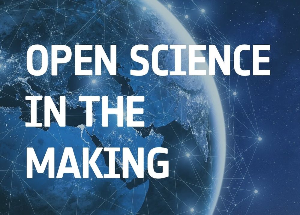
On my way to #LPS25 and looking forward to one week of condensed #earthobservation! Our team will present a broad portfolio of tree species unmixing, sea ice, land surface phenology, and human-made material mapping. Also come and chat with me during the open science in the making session - #FORCE_EO
22.06.2025 15:06 —
👍 9
🔁 1
💬 0
📌 0

MSc Geoinformatics at Trier University. Apply until May 30
The application window for our English-taught MSc in Geoinformatics is now open! Join us in Trier to become an expert in 🌞 #remotesensing, 🛰️ #earthobservation and 🗺️ #GIS! www.uni-trier.de/en/studium/s...
12.05.2025 12:44 —
👍 3
🔁 4
💬 0
📌 0
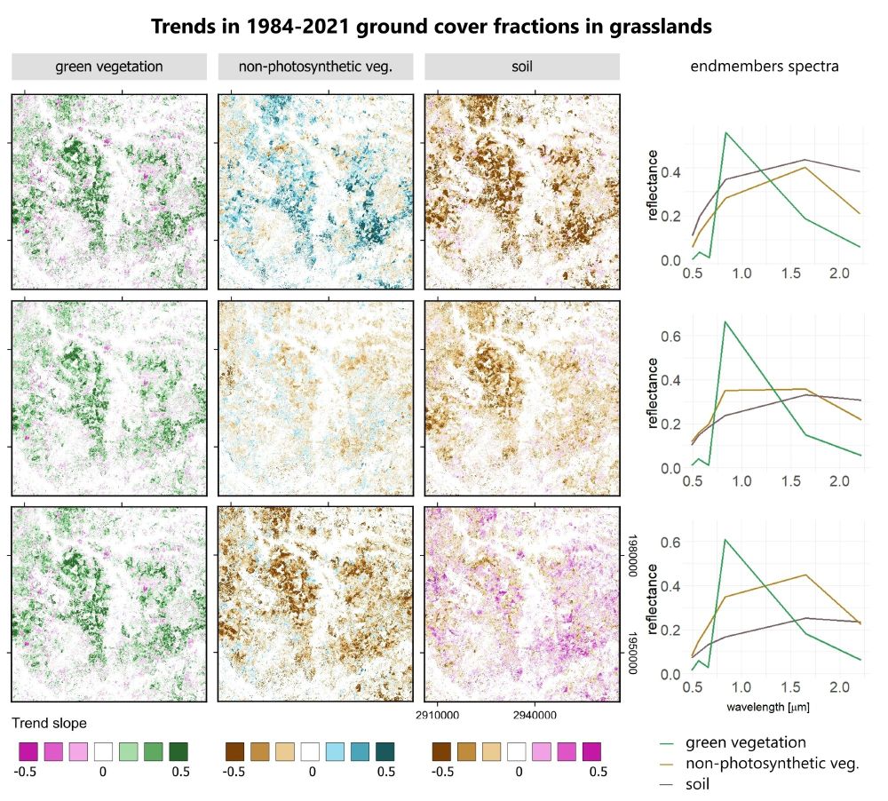
📣In our new paper we analyzed the impact of #Landsat and #Sentinel-2 🛰️ #satellite data density and SMA endmembers on trends in #grasslands ground cover:
- for monthly composites data density is irrelevant
- correct endmember definitions are critical‼️
Check out the full paper tinyurl.com/wha6pzax
04.04.2025 13:05 —
👍 24
🔁 10
💬 1
📌 1

Graphical Abstract
🚨 Fresh off the press in #RSE: D. Klehr's first #PhD chapter 🎉 presents a new approach to surpass classification of tree species for large areas 🛰️🌳🌲. We pair #Sentinel2 #EarthObservation with #ANN #AI models to predict sub-pixel tree species! #OpenAccess: www.sciencedirect.com/science/arti...
07.04.2025 13:38 —
👍 18
🔁 6
💬 0
📌 0
Thanks
02.04.2025 05:28 —
👍 0
🔁 0
💬 0
📌 0
Sounds great! Do you know any package that works in a similar way, but post-processes along the temporary dimension?
01.04.2025 20:01 —
👍 2
🔁 0
💬 1
📌 0

Opportunities
Kent State Campus. Credit: KSU
👉 👉 👉 We're hiring! Seeking a NASA-funded postdoc/PhD candidate to use #RemoteSensing and #machinelearning, particularly #deeplearning to study disaster impacts on #AgriculturalLand. Please share! www.senslandlab.com/opportunitie...
20.02.2025 16:07 —
👍 7
🔁 4
💬 0
📌 0
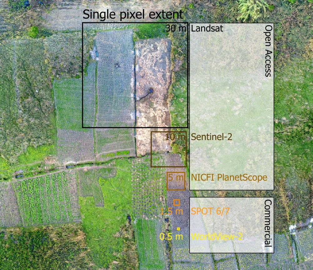
A drone capture of a smallholder farming landscape. Overlaid are squares of the size of typical optical satellite missions. Openly accessible data (e.g. Landsat or Sentinel-2) is often not sufficient to capture the landscape complexity in full detail, for example when trying to delineate individual fields. Here, one Landsat pixel contains fractions of multiple fields. Commercial data come at higher spatial resolution, offering potential to discriminate indivudual landscape components.
📣PNAS piece led by @philrufin.bsky.social: commercial very-high-resolution EO data is needed for monitoring SDG 2 indicators in smallholder landscapes but costs are prohibitive. A call for open access for sustainability-centered research: doi.org/10.1073/pnas... @humboldtuni.bsky.social
13.02.2025 09:28 —
👍 40
🔁 13
💬 0
📌 2

📣 New in Remote Sensing of Environment!
PhD candidate @lasseharkort.bsky.social and team introduce a novel Phenological Feature Space (PFS) approach for mapping fractional vegetation cover in Sub-Saharan rangelands using Sentinel-2 time series. 🛰️
🔗 doi.org/10.1016/j.rs...
13.02.2025 15:47 —
👍 17
🔁 6
💬 0
📌 2
Excellent to have you here! I joined 2mo ago, and so far it has been great :)
12.02.2025 19:04 —
👍 3
🔁 0
💬 0
📌 0
One week left to apply!
31.01.2025 19:44 —
👍 1
🔁 1
💬 0
📌 0
I'm so happy and proud of this decision 🙂. It is very important now to use the data, and compare the performances obtained with 2 and 3 satellites in your future communications. It will be the good way to thank @esa.int and #Copernicus.
27.01.2025 16:57 —
👍 19
🔁 7
💬 0
📌 2
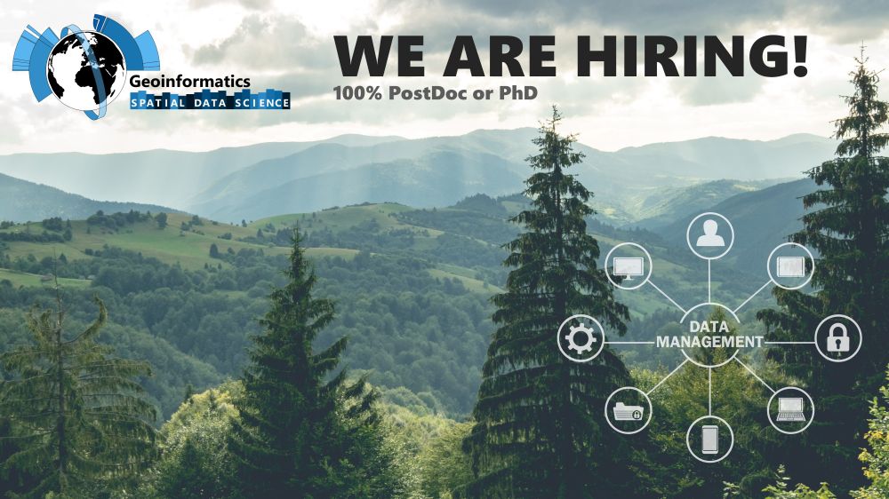
💼Job Alert: I am hiring a PostDoc/PhD (100%, 3yrs) to develop and orchestrate cloud-based workflows within a project that will create a forest information system 🌳 for Germany based on #sentinel2 🛰️ and #als ✈️. tinyurl.com/4hw426vw #RemoteSensing #EarthObservation @unitrier.bsky.social @thuenen.de
15.01.2025 12:28 —
👍 15
🔁 6
💬 1
📌 1
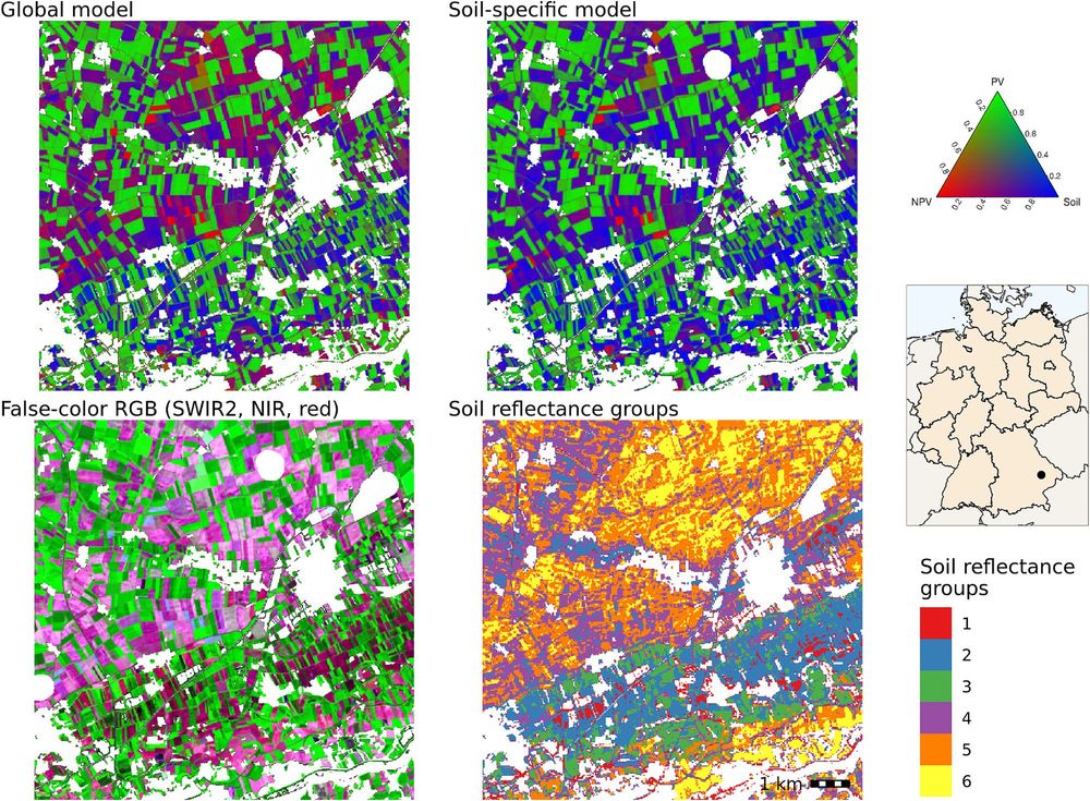
Happy to share our new paper on soil-specific unmixing of croplands in Germany led by Felix Lobert.
We adapted @katjakowalski.bsky.social’s approach using #Landsat and #Sentinel-2 🛰️ to account for soil variability using a soil reflectance composite developed at @thuenen.de EO:
tinyurl.com/5n92ae5z
13.01.2025 09:53 —
👍 27
🔁 7
💬 1
📌 0

Satelliten und Laser in der Waldforschung – Prof. Dr. Cornelius Senf zu seiner Forschung
YouTube video by DAAD Worldwide
🎥 How do we study forests using satellite and laser data? Here's a overview by our Prof. Cornelius Senf (@corneliussenf.bsky.social) in a short video produced by @daadworldwide.bsky.social (with English subs):
www.youtube.com/watch?si=KPm...
08.01.2025 17:20 —
👍 29
🔁 9
💬 0
📌 1

The first #sentinel2c #s2c image being processed by #FORCE_EO 🛰️ Data quality looks awesome!
20.12.2024 11:01 —
👍 10
🔁 4
💬 0
📌 0
Thanks!
20.12.2024 06:15 —
👍 0
🔁 0
💬 0
📌 0
Thanks!
20.12.2024 06:14 —
👍 0
🔁 0
💬 0
📌 0
We just got word for being funded 🎅🎉 The next 3 years, we will work with @thuenen.de and other partners to develop a web-based forest information system 🌲🌳 for Germany 🇩🇪based on 🛰️ #sentinel2 and 🛩️ #als. We will put out a job offering soon! Keep your eyes open here on bluesky for updates (⬆️ follow)
19.12.2024 17:07 —
👍 55
🔁 4
💬 2
📌 0

📢Our research on mapping societal material stocks 🏡🚗 is now featured on the #CDSE page as a use case! #sentinel1 #sentinel2 dataspace.copernicus.eu/cases/nation...
11.12.2024 13:42 —
👍 9
🔁 2
💬 1
📌 0
Hello World
11.12.2024 13:32 —
👍 8
🔁 0
💬 2
📌 0

📢Our research on mapping societal material stocks 🏡🚗 is now featured on the #CDSE page as a use case! #sentinel1 #sentinel2 https://dataspace.copernicus.eu/cases/national-scale-mapping-societal-material-stocks-using-copernicus-data @BOKU_SEC
10.12.2024 13:14 —
👍 1
🔁 0
💬 0
📌 0

🛰️🍷🌱🇩🇪 Are you interested in a fully-funded PhD position in #uav #remotesensing for health assessment of #vineyards for #precision #agriculture and #harvest #optimization? Apply here @TrierUni:
https://www.uni-trier.de/fileadmin/organisation/ABT3/Stellen_WissMitarbeiter/a55_24_WissMA_FB_VI_Umwelt...
07.11.2024 17:07 —
👍 1
🔁 0
💬 0
📌 0

How can #Sentinel2 satellite data enhance large-scale forest fire risk maps for locally adaptive management? The #BrandSat project by @TrierUni and @HumboldtUni's @HumboldtEOLab explores this crucial issue. #ForestFireRisk #RemoteSensing #ClimateAction
https://tinyurl.com/2s48st85
12.09.2024 06:54 —
👍 1
🔁 0
💬 0
📌 0
What is the fastest way to get global #sentinel2 metadata from CDSE? I am currently struggling with pages and item limits. All, and @azlinszky, do you have some suggestions?
22.07.2024 11:53 —
👍 0
🔁 0
💬 0
📌 0