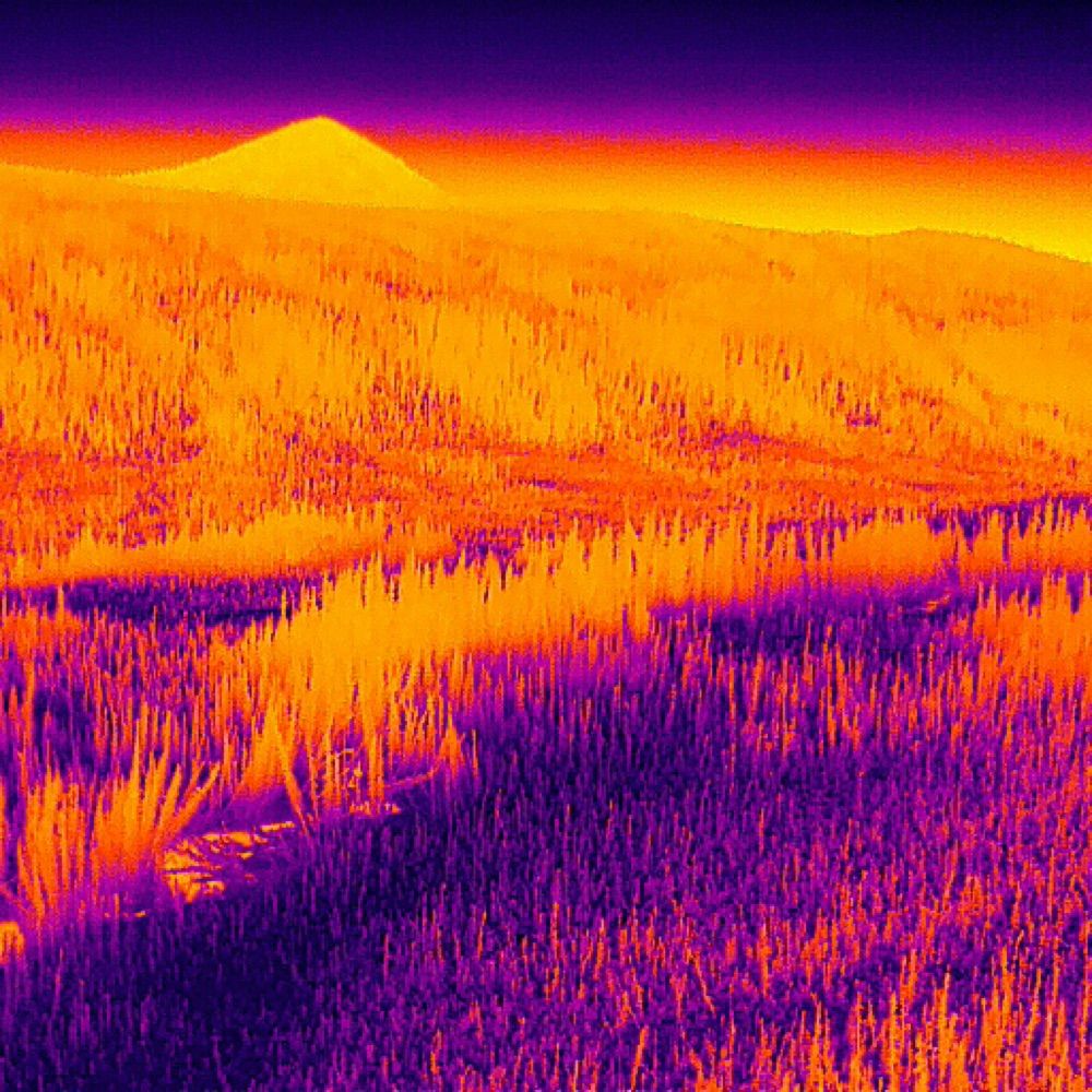
Just wrapped a successful field campaign at Volcán Poás, Costa Rica—part of our NSERC project on imaging & forecasting natural hazards using drones.
Check out the campaign video by @pabloscience.bsky.social l and great drone piloting by @belowwater.bsky.social !
@mcgillgeography.bsky.social
18.05.2025 19:15 — 👍 1 🔁 0 💬 0 📌 0
Looking forward to seeing AMEOS this coming year supporting our exciting collaborative projects funded by the Canadian Space Agency (ROSEO program) as well as the European Space Agency - ESA (Quality Assurance for Earth Observation Phase 2 Project)!
25.12.2024 20:58 — 👍 4 🔁 0 💬 0 📌 0
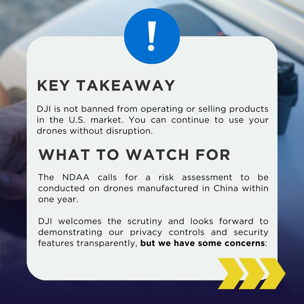
This week, the U.S. Congress passed the FY25 National Defense Authorization Act (NDAA).
While the Countering CCP Drones Act was not explicitly included, we have some concerns with certain provisions in the legislation.
Read our latest article on the DJI ViewPoints Blog: brnw.ch/21wPw8Y
19.12.2024 12:17 — 👍 9 🔁 4 💬 1 📌 0
Hi! The ARSlL is looking forward to trying out this new platform😁
We’ll post updates on the cool projects our lab is working on🛰️
#remotesensing #drone #satellite #lidar #thermal #hyperspectral #photogrammetry #airborne
21.12.2024 17:08 — 👍 5 🔁 2 💬 0 📌 0
The 20th year of the conference focusing on the applications of laser scanning & tech for assessing & managing forest ecosystems
📍Quebec City, Quebec, Canada
📅September 29 - October 3, 2025
💻 Silvilaser2025.com // #Silvilaser2025
Ecologist and remote sensing scientist working at the National Research Council of Canada (NRC). RPAS and manned airborne expert focused on understanding how climate change affects ecosystems around the World. Passionate about conservation and biodiversity
Geodesist and remote sensing research.
InSAR and remote sensing 🛰️
Postdoctoral research assistant - Purdue University
GeoLatinas
Personal opinions | ella-she-her
Learning to make science more inclusive, fair, and open.
Berlin based information designer with a passion for research and geospatial narratives | currently exploring satellite literacy
⤷ formerly #dataviz 🛰️ 🌍 @planet.com
⤷ Projects: julianpeschel.info
🌱 PhD researcher @rbgkew.bsky.social & @royalholloway.bsky.social
🌳 Landscape ecology | Nature-based Solutions | Multifunctional landscapes | Remote sensing | Nature conservation
http://linktr.ee/guivcastro
Earth Observation & Forest scientist #Biomass #ForestDynamics #Ecology #EarthEngine #MachineLearning #CapacityDevelopment #CarbonDiligence 🇬🇧🇪🇸
https://www.linkedin.com/in/pedrorodriguezveiga
🤖 Now Breezing v1.0.0
Bluesky's Trending Trend Words, on the :10s, every 10!
(trends weighted v. ~1 month of hist.)
🟢ONLINE!
Issues? Contact the Dev:
🦋 @nickwrightdata.ntw.app
💬(Signal): nickwrightdata.01
☕ https://ko-fi.com/nickwrightdata
“Controversial industry figure” - Grid News. VP of Commercial Experience at Umbra Space. 🛰 | satellite data for mapping 🗺, monitoring 📈, and 'mergencies 🚨
The #CopernicusClimate Change Service (#C3S) & #CopernicusAtmosphere Monitoring Service (CAMS), implemented by @ecmwf.int on behalf of the European Commission.
Data Visualization. Ex-Planet & NASA Earth Observatory. Blue Marble, Earth at Night, color, cartography, occasionally skewed views of Earth. Looking for a job.
Associate Professor @UTKnoxville | Amazon Scholar | Creator of #geemap & #leafmap | Talk about #Geospatial #GeoPython #DataViz #GIS #FOSS #EarthEngine
California Beach Biogeography & Geomorphology, Geospatial Data Science, Cartography, Open Source, Library Employee, and definitely some cats.
OSGeo - FOSS4G - #gischat - #maptimeDavis
Oceanographer at University of Liège (Belgium)
I work at the European Space Agency as the mission scientist for the Sentinel-2 and Sentinel-3 next generation missions.
I mainly post nice pictures of the Earth from space!
Note: Not an official ESA account, opinions are my own and mine alone!
Never stop being curious! Mostly optical remote sensing🛰️ with a focus on #wildfires🔥 and #SciComm. Some #wx . Sat images on Flickr ▶️ https://flickr.com/photos/pierre_markuse/
Linktree ▶️ https://linktr.ee/pierre_markuse
Esri Director of Imagery and Remote Sensing. Pixel pusher. Community builder.
Geologist & #EarthObservation Engineer at EUMETSAT/Innoflair. Decoding #ClimateRisks & #NaturalHazards.
Passionate about flood risks 🌊, geohazards ⚠️, weather 🌦️, remote sensing 🛰️, maps 🗺️, & risk comm 🚨.
Also in 🏀, ⛵️ and 👨🌾.
👉 www.niklasjordan.com | 🇪🇺🇩🇪🇩🇰
ECMWF senior scientist working on monitoring global #wildfire emissions, #airquality, atmospheric chemistry & #scicomm for the #CopernicusAtmosphere Monitoring Service @copernicusecmwf.bsky.social @ecmwf.int
Architect; 🛰️Satellites, 🗺️Maps & 🌐Geospatial - Porto Alegre, Brazil.
NatGeo Explorer, Oceanographer, Climate Scientist; Env. Remote Sensing; Energy & Sustainability; Professor & Chair KentStU ESCI, husband, father #FirstGen, Views my own; Google scholar: https://scholar.google.com/citations?hl=en&user=qMBuSe4AAAAJ