That’s why we need people who can bridge the gap—helping teams understand the potential, select the right datasets aligned with real project needs, and combining them with ground realities to generate practical insights.
07.05.2025 07:57 —
👍 0
🔁 0
💬 0
📌 0
But as the volume of data increases and the landscape expands, it may become harder for non-technical users to navigate and fully benefit from earth observation.
07.05.2025 07:57 —
👍 0
🔁 0
💬 1
📌 0
Second, the satellite data ecosystem will continue to grow—driven by ongoing research advancements, new satellite missions, and faster processing technologies. That’s good news.
07.05.2025 07:57 —
👍 0
🔁 0
💬 1
📌 0
In later stages, satellite data—when combined with knowledge from the field—can lead to more practical and robust insights than would be possible without it.
07.05.2025 07:57 —
👍 0
🔁 0
💬 1
📌 0
Even years later, the key lessons still apply:
First, satellite imagery should be seen as an input to your work. In the early stages, it helps you leverage its key advantages to generate initial observations, raise meaningful questions, and guide fieldwork.
07.05.2025 07:57 —
👍 0
🔁 0
💬 1
📌 0
A few years ago, I used satellite imagery for the first time in an impact evaluation with ADE in Rwanda—when COVID made fieldwork impossible. Applying satellite data in a real-life case helped me understand both its advantages and limitations —lessons I now share in this blog article.
07.05.2025 07:57 —
👍 0
🔁 0
💬 1
📌 0

An image of Esther Duflo and the quote: "The key to fighting poverty is not grand gestures, but small, tested interventions that actually work." - Esther Duflo
And more: French economist Esther Duflo has transformed the study of poverty and economic development, applying rigorous field experiments and geospatial analysis to assess real-world impacts. She has used GIS data to study how infrastructure projects—like dams and transportation networks—affect economic growth and poverty, ensuring that policies are backed by evidence rather than assumptions.
In 2019, she became the youngest person and only the second woman to receive the Nobel Prize in Economics, alongside Abhijit Banerjee and Michael Kremer. Her groundbreaking work combines economics, field research, and GIS mapping to create effective solutions for global poverty. Through her research, policymakers gain real insights into how geography shapes economic opportunity.
#WomensHistoryMonth Day 16: Esther Duflo revolutionized the fight against poverty by applying data-driven research and GIS analysis. A Nobel Laureate in Economics, she maps the impact of infrastructure & policies on communities, ensuring interventions truly work. #Shero #GISChat
16.03.2025 15:47 —
👍 9
🔁 3
💬 0
📌 0
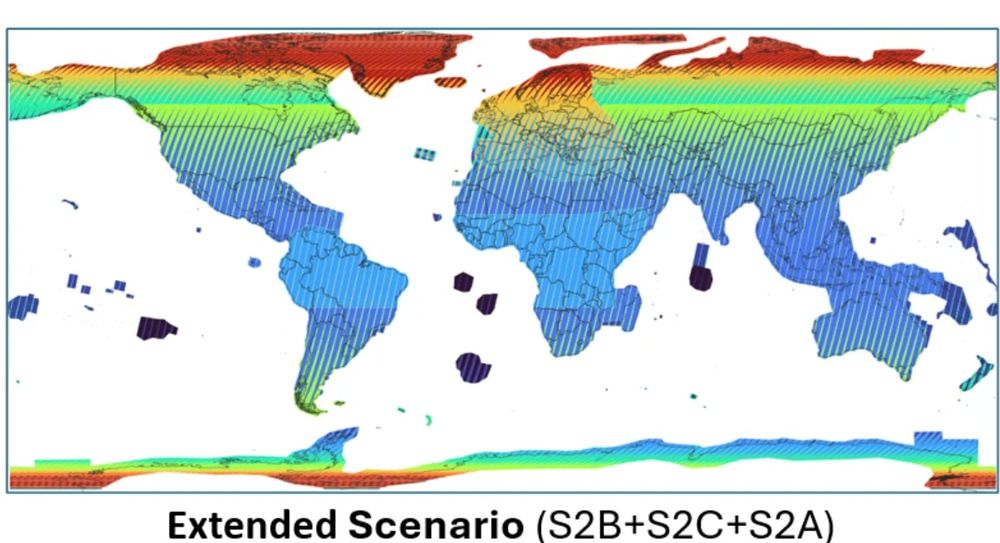
Sentinel-2A: Extended Campaign Starting March 13, 2025
Copernicus Data Space Ecosystem - Europe's eyes on Earth
⏰𝗥𝗲𝗺𝗶𝗻𝗱𝗲𝗿⏰
The #Sentinel-2A extension campaign begins in 𝘁𝘄𝗼 days, improving the global revisit frequency of the Sentinel-2 constellation. Particularly beneficial for observing tropical regions in Africa and South America with high #cloud cover.
buff.ly/lTEENhP
#earthobs #remotesensing
11.03.2025 07:02 —
👍 15
🔁 6
💬 0
📌 0
One of my favourite data discoveries this year: Google's mind-blowing ARCO-ERA5 dataset: hourly data for ~300 climate variables, available globally from 1940! 🤯
Loadable with a single line of Python code from a single cloud-friendly Zarr file! Below: a month of wind waves + swell: 🌊
27.11.2024 04:02 —
👍 688
🔁 157
💬 34
📌 15

Landsat 9 image from Depuch Island, Western Australia in true colour. It is showing a coastal scene with a red dust coastline, crystal blue waters and a volanic island just offshore.
We are lucky to be living on the most photogenic continent on the planet. This image from #Landsat taken yesterday shows the stunning Warmalana/Depuch Island in Western Australia. Check it out on #DigitalEarthAu Maps tinyurl.com/3ufr5f7a
21.11.2024 06:08 —
👍 32
🔁 6
💬 1
📌 0

🚀 Foursquare just launched Open Source Places (FSQ OS Places), a foundational open dataset featuring 100M+ global places of interest (POIs) with 22 core attributes. The dataset will be updated monthly!
🔗 Blog Post: lnkd.in/ehWVbNvq
📥 Access the data: opensource.foursquare.com/os-places
#geospatial
20.11.2024 15:16 —
👍 32
🔁 10
💬 1
📌 2

Queridos periodistas,
No se debe usar "desastre/catástrofe natural". Los desastres provocados por riesgos naturales son siempre el resultado de las acciones y las decisiones humanas. Un desastre no es natural y que las acciones humanas pueden prevenir y mitigar sus impactos. Aquí otros conceptos:
18.11.2024 15:48 —
👍 75
🔁 28
💬 2
📌 1

French Polynesia, Ocean Pacific 🏝️
Credits: Pléiades Neo, Airbus 2022
18.11.2024 14:56 —
👍 3
🔁 0
💬 0
📌 0


