GJT issues Area Forecast Discussion (AFD) at Aug 9, 11:54 AM MDT
at Sat, 09 Aug 2025 17:54:27 +0000 via IEMbot
Additional Details Here.
09.08.2025 18:08 — 👍 0 🔁 0 💬 0 📌 0
The Storm Prediction Center issues Day 1 Elevated Fire Weather Risk at Aug 9, 16:31z for portions of GJT
at Sat, 09 Aug 2025 16:33:14 +0000 via IEMbot
Additional Details Here.
09.08.2025 16:48 — 👍 0 🔁 0 💬 0 📌 0
GJT issues Air Quality Alert (AQA) at Aug 9, 9:10 AM MDT ...AIR QUALITY HEALTH ADVISORY FOR WILDFIRE SMOKE FROM 900 AM SATURDAY UNTIL 900 AM SUNDAY... via IEMbot
Additional Details Here.
09.08.2025 15:28 — 👍 0 🔁 0 💬 0 📌 0
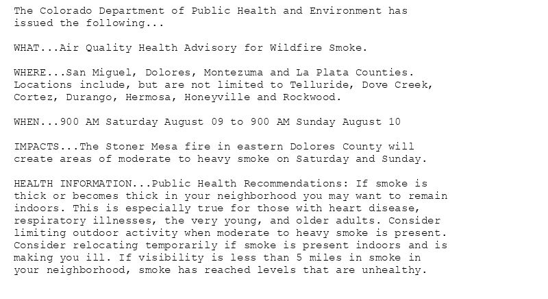
The Colorado Department of Public Health and Environment has
issued the following...
WHAT...Air Quality Health Advisory for Wildfire Smoke.
WHERE...San Miguel, Dolores, Montezuma and La Plata Counties.
Locations include, but are not limited to Telluride, Dove Creek,
Cortez, Durango, Hermosa, Honeyville and Rockwood.
WHEN...900 AM Saturday August 09 to 900 AM Sunday August 10
IMPACTS...The Stoner Mesa fire in eastern Dolores County will
create areas of moderate to heavy smoke on Saturday and Sunday.
HEALTH INFORMATION...Public Health Recommendations: If smoke is
thick or becomes thick in your neighborhood you may want to remain
indoors. This is especially true for those with heart disease,
respiratory illnesses, the very young, and older adults. Consider
limiting outdoor activity when moderate to heavy smoke is present.
Consider relocating temporarily if smoke is present indoors and is
making you ill. If visibility is less than 5 miles in smoke in
your neighborhood, smoke has reached levels that are unhealthy.
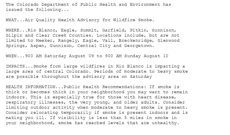
The Colorado Department of Public Health and Environment has
issued the following...
WHAT...Air Quality Health Advisory for Wildfire Smoke.
WHERE...Rio Blanco, Eagle, Summit, Garfield, Pitkin, Gunnison,
Gilpin and Clear Creek Counties. Locations include, but are not
limited to Meeker, Rangely, Eagle, Vail, Breckenridge, Glenwood
Springs, Aspen, Gunnison, Central City and Georgetown.
WHEN...900 AM Saturday August 09 to 900 AM Sunday August 10
IMPACTS...Smoke from large wildfires in Rio Blanco is impacting a
large area of central Colorado. Periods of moderate to heavy smoke
are possible throughout the advisory area on Saturday
HEALTH INFORMATION...Public Health Recommendations: If smoke is
thick or becomes thick in your neighborhood you may want to remain
indoors. This is especially true for those with heart disease,
respiratory illnesses, the very young, and older adults. Consider
limiting outdoor activity when moderate to heavy smoke is present.
Consider relocating temporarily if smoke is present indoors and is
making you ill. If visibility is less than 5 miles in smoke in
your neighborhood, smoke has reached levels that are unhealthy.
Air Quality Alert issued August 9 at 9:10AM MDT by NWS Grand Junction CO
Additional Details Here.
09.08.2025 15:15 — 👍 0 🔁 0 💬 0 📌 0
GJT issues Area Forecast Discussion (AFD) at Aug 9, 5:14 AM MDT
at Sat, 09 Aug 2025 11:15:37 +0000 via IEMbot
Additional Details Here.
09.08.2025 11:28 — 👍 0 🔁 0 💬 0 📌 0
GJT issues Area Forecast Discussion (AFD) at Aug 9, 3:15 AM MDT
at Sat, 09 Aug 2025 09:16:46 +0000 via IEMbot
Additional Details Here.
09.08.2025 09:28 — 👍 0 🔁 0 💬 0 📌 0
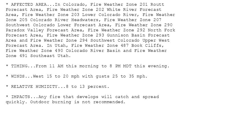
* AFFECTED AREA...In Colorado, Fire Weather Zone 201 Routt
Forecast Area, Fire Weather Zone 202 White River Forecast
Area, Fire Weather Zone 203 Lower Colorado River, Fire Weather
Zone 205 Colorado River Headwaters, Fire Weather Zone 207
Southwest Colorado Lower Forecast Area, Fire Weather Zone 290
Paradox Valley Forecast Area, Fire Weather Zone 292 North Fork
Forecast Area, Fire Weather Zone 293 Gunnison Basin Forecast
Area and Fire Weather Zone 294 Southwest Colorado Upper West
Forecast Area. In Utah, Fire Weather Zone 487 Book Cliffs,
Fire Weather Zone 490 Colorado River Basin and Fire Weather
Zone 491 Southeast Utah.
* TIMING...From 11 AM this morning to 8 PM MDT this evening.
* WINDS...West 15 to 20 mph with gusts 25 to 35 mph.
* RELATIVE HUMIDITY...8 to 13 percent.
* IMPACTS...Any fire that develops will catch and spread
quickly. Outdoor burning is not recommended.
🚨 Red Flag Warning issued August 9 at 2:25AM MDT until August 9 at 8:00PM MDT by NWS Grand Junction CO 🚨
Additional Details Here.
09.08.2025 08:30 — 👍 0 🔁 0 💬 0 📌 0
MONTROSE CO Aug 8
Climate Report:
High: 96
Low: 65
Precip: 0.0"
Snow: Missing
at Sat, 09 Aug 2025 07:26:47 +0000 via IEMbot
Additional Details Here.
09.08.2025 07:48 — 👍 0 🔁 0 💬 0 📌 0
CORTEZ CO Aug 8
Climate Report:
High: 96
Low: 55
Precip: 0.0"
Snow: Missing
at Sat, 09 Aug 2025 07:26:45 +0000 via IEMbot
Additional Details Here.
09.08.2025 07:28 — 👍 0 🔁 0 💬 0 📌 0
DURANGO AIRPORT CO Aug 8
Climate Report:
High: 94
Low: 59
Precip: 0.0"
Snow: Missing
at Sat, 09 Aug 2025 07:26:47 +0000 via IEMbot
Additional Details Here.
09.08.2025 07:28 — 👍 0 🔁 0 💬 0 📌 0
GRAND JUNCTION CO Aug 8
Climate Report:
High: 99
Low: 72
Precip: 0.0"
Snow: 0.0" Snow Depth: 0"
at Sat, 09 Aug 2025 07:26:49 +0000 via IEMbot
Additional Details Here.
09.08.2025 07:28 — 👍 0 🔁 0 💬 0 📌 0
The Storm Prediction Center issues Day 1 Elevated Fire Weather Risk at Aug 9, 6:18z for portions of GJT
at Sat, 09 Aug 2025 06:19:12 +0000 via IEMbot
Additional Details Here.
09.08.2025 06:28 — 👍 0 🔁 0 💬 0 📌 0
GJT issues Area Forecast Discussion (AFD) at Aug 8, 11:15 PM MDT
at Sat, 09 Aug 2025 05:17:15 +0000 via IEMbot
Additional Details Here.
09.08.2025 05:28 — 👍 0 🔁 0 💬 0 📌 0
GJT expires Red Flag Warning for Colorado River Headwaters, Gunnison Basin, Lower Colorado River, North Fork, Paradox Valley, Routt, Southwest Colorado Lower Forecast Area, Southwe... at Sat, 09 Aug 2025 03:48:14 +0000 via IEMbot
Additional Details Here.
09.08.2025 04:07 — 👍 1 🔁 0 💬 0 📌 0
GJT issues Area Forecast Discussion (AFD) at Aug 8, 10:02 PM MDT
at Sat, 09 Aug 2025 04:03:54 +0000 via IEMbot
Additional Details Here.
09.08.2025 04:07 — 👍 0 🔁 0 💬 0 📌 0
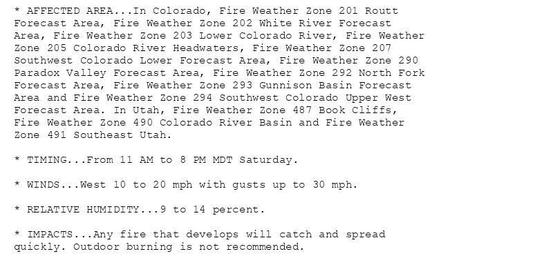
* AFFECTED AREA...In Colorado, Fire Weather Zone 201 Routt
Forecast Area, Fire Weather Zone 202 White River Forecast
Area, Fire Weather Zone 203 Lower Colorado River, Fire Weather
Zone 205 Colorado River Headwaters, Fire Weather Zone 207
Southwest Colorado Lower Forecast Area, Fire Weather Zone 290
Paradox Valley Forecast Area, Fire Weather Zone 292 North Fork
Forecast Area, Fire Weather Zone 293 Gunnison Basin Forecast
Area and Fire Weather Zone 294 Southwest Colorado Upper West
Forecast Area. In Utah, Fire Weather Zone 487 Book Cliffs,
Fire Weather Zone 490 Colorado River Basin and Fire Weather
Zone 491 Southeast Utah.
* TIMING...From 11 AM to 8 PM MDT Saturday.
* WINDS...West 10 to 20 mph with gusts up to 30 mph.
* RELATIVE HUMIDITY...9 to 14 percent.
* IMPACTS...Any fire that develops will catch and spread
quickly. Outdoor burning is not recommended.
🚨 Red Flag Warning issued August 8 at 9:48PM MDT until August 9 at 8:00PM MDT by NWS Grand Junction CO 🚨
Additional Details Here.
09.08.2025 04:00 — 👍 0 🔁 0 💬 0 📌 0
GJT extends time of Red Flag Warning for Colorado River Headwaters, Gunnison Basin, Lower Colorado River, North Fork, Paradox Valley, Routt, Southwest Colorado Lower Forecast Area,... at Sat, 09 Aug 2025 01:53:40 +0000 via IEMbot
Additional Details Here.
09.08.2025 02:07 — 👍 0 🔁 0 💬 0 📌 0
GJT issues Area Forecast Discussion (AFD) at Aug 8, 8:03 PM MDT
at Sat, 09 Aug 2025 02:04:18 +0000 via IEMbot
Additional Details Here.
09.08.2025 02:07 — 👍 0 🔁 0 💬 0 📌 0
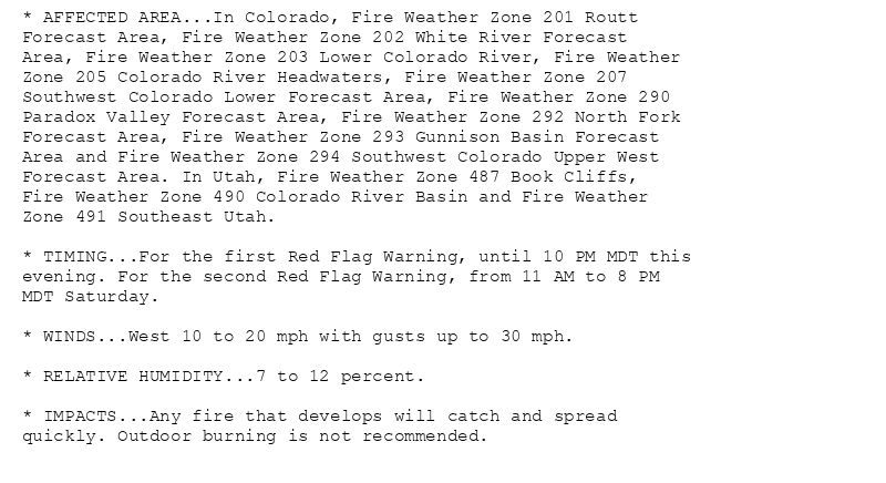
* AFFECTED AREA...In Colorado, Fire Weather Zone 201 Routt
Forecast Area, Fire Weather Zone 202 White River Forecast
Area, Fire Weather Zone 203 Lower Colorado River, Fire Weather
Zone 205 Colorado River Headwaters, Fire Weather Zone 207
Southwest Colorado Lower Forecast Area, Fire Weather Zone 290
Paradox Valley Forecast Area, Fire Weather Zone 292 North Fork
Forecast Area, Fire Weather Zone 293 Gunnison Basin Forecast
Area and Fire Weather Zone 294 Southwest Colorado Upper West
Forecast Area. In Utah, Fire Weather Zone 487 Book Cliffs,
Fire Weather Zone 490 Colorado River Basin and Fire Weather
Zone 491 Southeast Utah.
* TIMING...For the first Red Flag Warning, until 10 PM MDT this
evening. For the second Red Flag Warning, from 11 AM to 8 PM
MDT Saturday.
* WINDS...West 10 to 20 mph with gusts up to 30 mph.
* RELATIVE HUMIDITY...7 to 12 percent.
* IMPACTS...Any fire that develops will catch and spread
quickly. Outdoor burning is not recommended.
* AFFECTED AREA...In Colorado, Fire Weather Zone 200 Little
Snake Forecast Area. In Utah, Fire Weather Zone 485 Eastern
Ashley National Forest and Fire Weather Zone 486 Eastern Uinta
Basin.
* TIMING...Until 10 PM MDT this evening.
* WINDS...Northwest 10 to 15 mph with gusts up to 30 mph.
* RELATIVE HUMIDITY...12 to 17 percent.
* IMPACTS...Any fire that develops will catch and spread
quickly. Outdoor burning is not recommended.
🚨 Red Flag Warning issued August 8 at 7:53PM MDT until August 8 at 10:00PM MDT by NWS Grand Junction CO 🚨
Additional Details Here.
09.08.2025 02:00 — 👍 0 🔁 0 💬 0 📌 0
ASPEN CO Aug 8
Climate Report:
High: 85
Low: 57
Precip: 0.0"
Snow: Missing
at Fri, 08 Aug 2025 23:40:19 +0000 via IEMbot
Additional Details Here.
08.08.2025 23:48 — 👍 0 🔁 0 💬 0 📌 0
CANYONLANDS AIRPORT UT Aug 8
Climate Report:
High: 101
Low: 72
Precip: 0.0"
Snow: Missing
at Fri, 08 Aug 2025 23:40:20 +0000 via IEMbot
Additional Details Here.
08.08.2025 23:48 — 👍 0 🔁 0 💬 0 📌 0
MONTROSE CO Aug 8
Climate Report:
High: 96
Low: 65
Precip: 0.0"
Snow: Missing
at Fri, 08 Aug 2025 23:40:20 +0000 via IEMbot
Additional Details Here.
08.08.2025 23:48 — 👍 0 🔁 0 💬 0 📌 0
GJT issues Area Forecast Discussion (AFD) at Aug 8, 5:24 PM MDT
at Fri, 08 Aug 2025 23:25:06 +0000 via IEMbot
Additional Details Here.
08.08.2025 23:28 — 👍 0 🔁 0 💬 0 📌 0
GJT issues Area Forecast Discussion (AFD) at Aug 8, 3:00 PM MDT
at Fri, 08 Aug 2025 21:01:06 +0000 via IEMbot
Additional Details Here.
08.08.2025 21:08 — 👍 0 🔁 0 💬 0 📌 0
GJT continues Red Flag Warning for Colorado River Headwaters, Gunnison Basin, Lower Colorado River, North Fork, Paradox Valley, Routt, Southwest Colorado Lower Forecast Area, South... at Fri, 08 Aug 2025 19:40:58 +0000 via IEMbot
Additional Details Here.
08.08.2025 19:48 — 👍 0 🔁 0 💬 0 📌 0
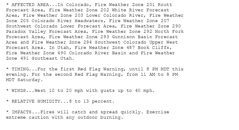
* AFFECTED AREA...In Colorado, Fire Weather Zone 201 Routt
Forecast Area, Fire Weather Zone 202 White River Forecast
Area, Fire Weather Zone 203 Lower Colorado River, Fire Weather
Zone 205 Colorado River Headwaters, Fire Weather Zone 207
Southwest Colorado Lower Forecast Area, Fire Weather Zone 290
Paradox Valley Forecast Area, Fire Weather Zone 292 North Fork
Forecast Area, Fire Weather Zone 293 Gunnison Basin Forecast
Area and Fire Weather Zone 294 Southwest Colorado Upper West
Forecast Area. In Utah, Fire Weather Zone 487 Book Cliffs,
Fire Weather Zone 490 Colorado River Basin and Fire Weather
Zone 491 Southeast Utah.
* TIMING...For the first Red Flag Warning, until 8 PM MDT this
evening. For the second Red Flag Warning, from 11 AM to 8 PM
MDT Saturday.
* WINDS...West 10 to 20 mph with gusts up to 40 mph.
* RELATIVE HUMIDITY...8 to 13 percent.
* IMPACTS...Fires will catch and spread quickly. Exercise
extreme caution with any outdoor burning.
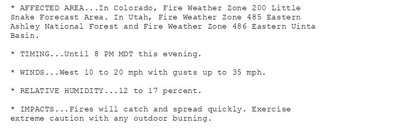
* AFFECTED AREA...In Colorado, Fire Weather Zone 200 Little
Snake Forecast Area. In Utah, Fire Weather Zone 485 Eastern
Ashley National Forest and Fire Weather Zone 486 Eastern Uinta
Basin.
* TIMING...Until 8 PM MDT this evening.
* WINDS...West 10 to 20 mph with gusts up to 35 mph.
* RELATIVE HUMIDITY...12 to 17 percent.
* IMPACTS...Fires will catch and spread quickly. Exercise
extreme caution with any outdoor burning.
🚨 Red Flag Warning issued August 8 at 1:40PM MDT until August 8 at 8:00PM MDT by NWS Grand Junction CO 🚨
Additional Details Here.
08.08.2025 19:45 — 👍 0 🔁 0 💬 0 📌 0
GJT issues Area Forecast Discussion (AFD) at Aug 8, 11:37 AM MDT
at Fri, 08 Aug 2025 17:37:23 +0000 via IEMbot
Additional Details Here.
08.08.2025 17:48 — 👍 0 🔁 0 💬 0 📌 0
The Storm Prediction Center issues Day 1 Isolated Dry Thunderstorm Fire Weather Risk at Aug 8, 16:41z for portions of GJT
at Fri, 08 Aug 2025 16:42:12 +0000 via IEMbot
Additional Details Here.
08.08.2025 16:48 — 👍 0 🔁 0 💬 0 📌 0
GJT issues Air Quality Alert (AQA) at Aug 8, 9:10 AM MDT ...AIR QUALITY HEALTH ADVISORY FOR WILDFIRE SMOKE FROM 900 AM FRIDAY UNTIL 900 AM SATURDAY... via IEMbot
Additional Details Here.
08.08.2025 15:28 — 👍 0 🔁 0 💬 0 📌 0
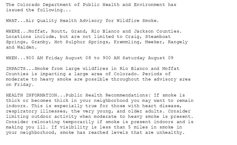
The Colorado Department of Public Health and Environment has
issued the following...
WHAT...Air Quality Health Advisory for Wildfire Smoke.
WHERE...Moffat, Routt, Grand, Rio Blanco and Jackson Counties.
Locations include, but are not limited to Craig, Steamboat
Springs, Granby, Hot Sulphur Springs, Kremmling, Meeker, Rangely
and Walden.
WHEN...900 AM Friday August 08 to 900 AM Saturday August 09
IMPACTS...Smoke from large wildfires in Rio Blanco and Moffat
Counties is impacting a large area of Colorado. Periods of
moderate to heavy smoke are possible throughout the advisory area
on Friday.
HEALTH INFORMATION...Public Health Recommendations: If smoke is
thick or becomes thick in your neighborhood you may want to remain
indoors. This is especially true for those with heart disease,
respiratory illnesses, the very young, and older adults. Consider
limiting outdoor activity when moderate to heavy smoke is present.
Consider relocating temporarily if smoke is present indoors and is
making you ill. If visibility is less than 5 miles in smoke in
your neighborhood, smoke has reached levels that are unhealthy.
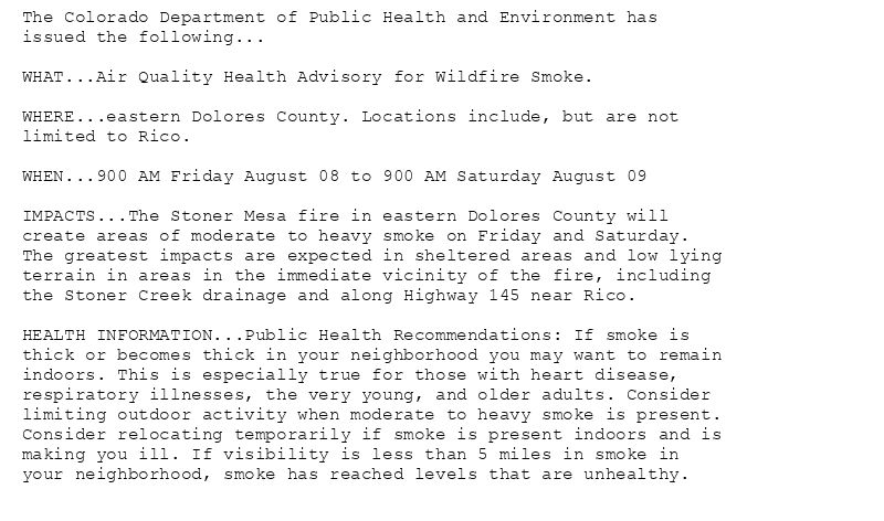
The Colorado Department of Public Health and Environment has
issued the following...
WHAT...Air Quality Health Advisory for Wildfire Smoke.
WHERE...eastern Dolores County. Locations include, but are not
limited to Rico.
WHEN...900 AM Friday August 08 to 900 AM Saturday August 09
IMPACTS...The Stoner Mesa fire in eastern Dolores County will
create areas of moderate to heavy smoke on Friday and Saturday.
The greatest impacts are expected in sheltered areas and low lying
terrain in areas in the immediate vicinity of the fire, including
the Stoner Creek drainage and along Highway 145 near Rico.
HEALTH INFORMATION...Public Health Recommendations: If smoke is
thick or becomes thick in your neighborhood you may want to remain
indoors. This is especially true for those with heart disease,
respiratory illnesses, the very young, and older adults. Consider
limiting outdoor activity when moderate to heavy smoke is present.
Consider relocating temporarily if smoke is present indoors and is
making you ill. If visibility is less than 5 miles in smoke in
your neighborhood, smoke has reached levels that are unhealthy.
Air Quality Alert issued August 8 at 9:10AM MDT by NWS Grand Junction CO
Additional Details Here.
08.08.2025 15:15 — 👍 0 🔁 0 💬 0 📌 0