PUB issues Area Forecast Discussion (AFD) at Aug 12, 2:50 PM MDT
at Tue, 12 Aug 2025 20:51:47 +0000 via IEMbot
Additional Details Here.
12.08.2025 21:07 — 👍 0 🔁 0 💬 0 📌 0
PUB issues Fire Weather Watch valid at Aug 14, 12:00 PM MDT for Eastern San Juan Mountains and La Garita Mountains Including Wolf Creek Pass and Creede, Fremont County Including Ca... at Tue, 12 Aug 2025 20:43:35 +0000 via IEMbot
Additional Details Here.
12.08.2025 20:47 — 👍 0 🔁 0 💬 0 📌 0
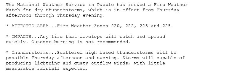
The National Weather Service in Pueblo has issued a Fire Weather
Watch for dry thunderstorms, which is in effect from Thursday
afternoon through Thursday evening.
* AFFECTED AREA...Fire Weather Zones 220, 222, 223 and 225.
* IMPACTS...Any fire that develops will catch and spread
quickly. Outdoor burning is not recommended.
* Thunderstorms...Scattered high based thunderstorms will be
possible Thursday afternoon and evening. Storms will capable of
producing lightning and gusty outflow winds, with little
measurable rainfall expected.
🚨 Fire Weather Watch issued August 12 at 2:43PM MDT until August 14 at 10:00PM MDT by NWS Pueblo CO 🚨
Additional Details Here.
12.08.2025 20:45 — 👍 0 🔁 0 💬 0 📌 0
PUB issues Hazardous Weather Outlook (HWO) at Aug 12, 1:26 PM MDT
at Tue, 12 Aug 2025 19:27:46 +0000 via IEMbot
Additional Details Here.
12.08.2025 19:47 — 👍 0 🔁 0 💬 0 📌 0
PUB issues Area Forecast Discussion (AFD) at Aug 12, 11:06 AM MDT
at Tue, 12 Aug 2025 17:06:24 +0000 via IEMbot
Additional Details Here.
12.08.2025 17:07 — 👍 0 🔁 0 💬 0 📌 0
PUB issues Hazardous Weather Outlook (HWO) at Aug 12, 4:34 AM MDT
at Tue, 12 Aug 2025 10:34:18 +0000 via IEMbot
Additional Details Here.
12.08.2025 10:47 — 👍 0 🔁 0 💬 0 📌 0
PUB issues Area Forecast Discussion (AFD) at Aug 12, 4:18 AM MDT
at Tue, 12 Aug 2025 10:18:37 +0000 via IEMbot
Additional Details Here.
12.08.2025 10:27 — 👍 0 🔁 0 💬 0 📌 0
LEADVILLE CO Aug 11
Climate Report:
High: 72
Low: 28
Precip: 0.0"
Snow: Missing
at Tue, 12 Aug 2025 07:23:27 +0000 via IEMbot
Additional Details Here.
12.08.2025 07:27 — 👍 0 🔁 0 💬 0 📌 0
TRINIDAD CO Aug 11
Climate Report:
High: 81
Low: 54
Precip: Trace
Snow: Missing
at Tue, 12 Aug 2025 07:23:28 +0000 via IEMbot
Additional Details Here.
12.08.2025 07:27 — 👍 0 🔁 0 💬 0 📌 0
PUB issues Area Forecast Discussion (AFD) at Aug 11, 11:06 PM MDT
at Tue, 12 Aug 2025 05:06:30 +0000 via IEMbot
Additional Details Here.
12.08.2025 05:08 — 👍 0 🔁 0 💬 0 📌 0
PUB issues Hazardous Weather Outlook (HWO) at Aug 11, 7:44 PM MDT
at Tue, 12 Aug 2025 01:45:37 +0000 via IEMbot
Additional Details Here.
12.08.2025 01:47 — 👍 0 🔁 0 💬 0 📌 0
ALAMOSA CO Aug 11
Climate Report:
High: 80
Low: 42
Precip: 0.0"
Snow: Missing
at Tue, 12 Aug 2025 00:34:13 +0000 via IEMbot
Additional Details Here.
12.08.2025 00:47 — 👍 0 🔁 0 💬 0 📌 0
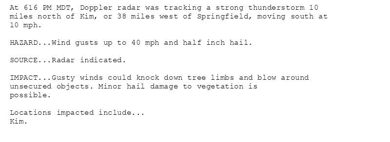
At 616 PM MDT, Doppler radar was tracking a strong thunderstorm 10
miles north of Kim, or 38 miles west of Springfield, moving south at
10 mph.
HAZARD...Wind gusts up to 40 mph and half inch hail.
SOURCE...Radar indicated.
IMPACT...Gusty winds could knock down tree limbs and blow around
unsecured objects. Minor hail damage to vegetation is
possible.
Locations impacted include...
Kim.
Special Weather Statement issued August 11 at 6:16PM MDT by NWS Pueblo CO
Additional Details Here.
12.08.2025 00:30 — 👍 0 🔁 0 💬 0 📌 0
PUB expires Severe Thunderstorm Warning for Baca, Las Animas [CO]
at Tue, 12 Aug 2025 00:12:38 +0000 via IEMbot
Additional Details Here.
12.08.2025 00:27 — 👍 0 🔁 0 💬 0 📌 0
PUB continues Severe Thunderstorm Warning [wind: 60 MPH (RADAR INDICATED), hail: 1.00 IN (RADAR INDICATED)] for Baca, Las Animas [CO] till 6:15 PM MDT
at Mon, 11 Aug 2025 23:59:14 +0000 via IEMbot
Additional Details Here.
12.08.2025 00:07 — 👍 0 🔁 0 💬 0 📌 0
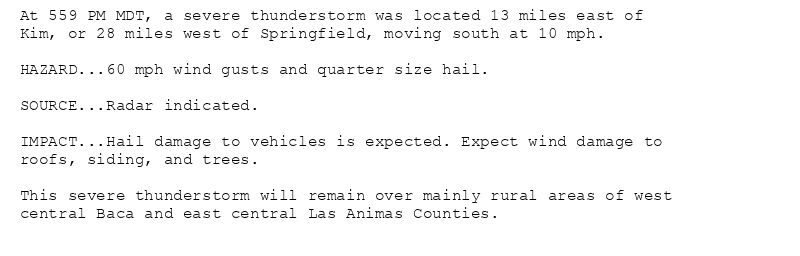
At 559 PM MDT, a severe thunderstorm was located 13 miles east of
Kim, or 28 miles west of Springfield, moving south at 10 mph.
HAZARD...60 mph wind gusts and quarter size hail.
SOURCE...Radar indicated.
IMPACT...Hail damage to vehicles is expected. Expect wind damage to
roofs, siding, and trees.
This severe thunderstorm will remain over mainly rural areas of west
central Baca and east central Las Animas Counties.
🚨 Severe Thunderstorm Warning issued August 11 at 5:59PM MDT until August 11 at 6:15PM MDT by NWS Pueblo CO 🚨
Additional Details Here.
12.08.2025 00:00 — 👍 0 🔁 0 💬 0 📌 0
PUB issues Area Forecast Discussion (AFD) at Aug 11, 5:28 PM MDT
at Mon, 11 Aug 2025 23:29:07 +0000 via IEMbot
Additional Details Here.
11.08.2025 23:47 — 👍 0 🔁 0 💬 0 📌 0
COLORADO SPRINGS CO Aug 11
Climate Report:
High: 79
Low: 53
Precip: 0.0"
Snow: Missing
at Mon, 11 Aug 2025 23:33:36 +0000 via IEMbot
Additional Details Here.
11.08.2025 23:47 — 👍 0 🔁 0 💬 0 📌 0
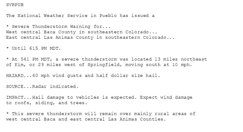
SVRPUB
The National Weather Service in Pueblo has issued a
* Severe Thunderstorm Warning for...
West central Baca County in southeastern Colorado...
East central Las Animas County in southeastern Colorado...
* Until 615 PM MDT.
* At 541 PM MDT, a severe thunderstorm was located 13 miles northeast
of Kim, or 29 miles west of Springfield, moving south at 10 mph.
HAZARD...60 mph wind gusts and half dollar size hail.
SOURCE...Radar indicated.
IMPACT...Hail damage to vehicles is expected. Expect wind damage
to roofs, siding, and trees.
* This severe thunderstorm will remain over mainly rural areas of
west central Baca and east central Las Animas Counties.
🚨 Severe Thunderstorm Warning issued August 11 at 5:41PM MDT until August 11 at 6:15PM MDT by NWS Pueblo CO 🚨
Additional Details Here.
11.08.2025 23:45 — 👍 0 🔁 0 💬 0 📌 0
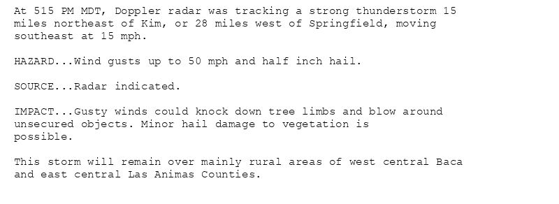
At 515 PM MDT, Doppler radar was tracking a strong thunderstorm 15
miles northeast of Kim, or 28 miles west of Springfield, moving
southeast at 15 mph.
HAZARD...Wind gusts up to 50 mph and half inch hail.
SOURCE...Radar indicated.
IMPACT...Gusty winds could knock down tree limbs and blow around
unsecured objects. Minor hail damage to vegetation is
possible.
This storm will remain over mainly rural areas of west central Baca
and east central Las Animas Counties.
Special Weather Statement issued August 11 at 5:15PM MDT by NWS Pueblo CO
Additional Details Here.
11.08.2025 23:30 — 👍 0 🔁 0 💬 0 📌 0
PUB issues A STRONG THUNDERSTORM WILL IMPACT NORTHEASTERN KIOWA COUNTY THROUGH 545 PM MDT [wind: 50 MPH, hail: 0.25 IN]
at Mon, 11 Aug 2025 23:12:26 +0000 via IEMbot
Additional Details Here.
11.08.2025 23:27 — 👍 0 🔁 0 💬 0 📌 0
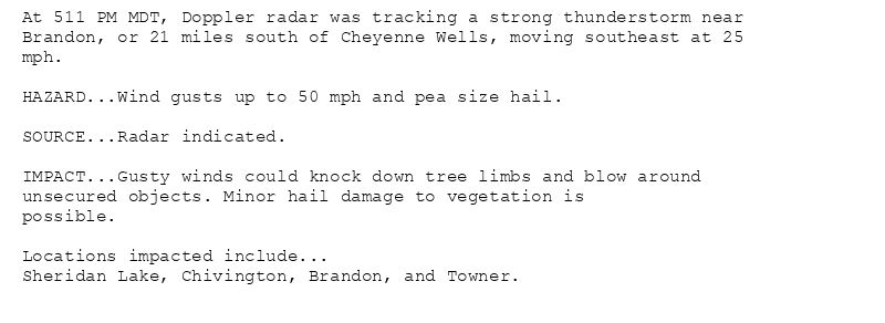
At 511 PM MDT, Doppler radar was tracking a strong thunderstorm near
Brandon, or 21 miles south of Cheyenne Wells, moving southeast at 25
mph.
HAZARD...Wind gusts up to 50 mph and pea size hail.
SOURCE...Radar indicated.
IMPACT...Gusty winds could knock down tree limbs and blow around
unsecured objects. Minor hail damage to vegetation is
possible.
Locations impacted include...
Sheridan Lake, Chivington, Brandon, and Towner.
Special Weather Statement issued August 11 at 5:12PM MDT by NWS Pueblo CO
Additional Details Here.
11.08.2025 23:15 — 👍 0 🔁 0 💬 0 📌 0
PUB issues STRONG THUNDERSTORMS WILL IMPACT SOUTHEASTERN LAS ANIMAS COUNTY THROUGH 530 PM MDT [wind: 40 MPH, hail: 0.25 IN] for Eastern Las Animas County, Trinidad Vicinity/Wester... at Mon, 11 Aug 2025 22:52:33 +0000 via IEMbot
Additional Details Here.
11.08.2025 23:07 — 👍 0 🔁 0 💬 0 📌 0
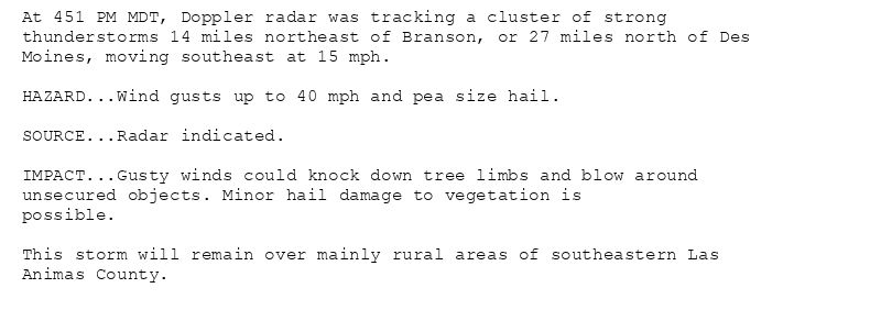
At 451 PM MDT, Doppler radar was tracking a cluster of strong
thunderstorms 14 miles northeast of Branson, or 27 miles north of Des
Moines, moving southeast at 15 mph.
HAZARD...Wind gusts up to 40 mph and pea size hail.
SOURCE...Radar indicated.
IMPACT...Gusty winds could knock down tree limbs and blow around
unsecured objects. Minor hail damage to vegetation is
possible.
This storm will remain over mainly rural areas of southeastern Las
Animas County.
Special Weather Statement issued August 11 at 4:52PM MDT by NWS Pueblo CO
Additional Details Here.
11.08.2025 23:00 — 👍 0 🔁 0 💬 0 📌 0
PUB issues A STRONG THUNDERSTORM WILL IMPACT NORTH CENTRAL KIOWA COUNTY THROUGH 515 PM MDT [wind: 50 MPH, hail: 0.50 IN] for Eastern Kiowa County, Western Kiowa County [CO]
at Mo... at Mon, 11 Aug 2025 22:32:32 +0000 via IEMbot
Additional Details Here.
11.08.2025 22:47 — 👍 0 🔁 0 💬 0 📌 0
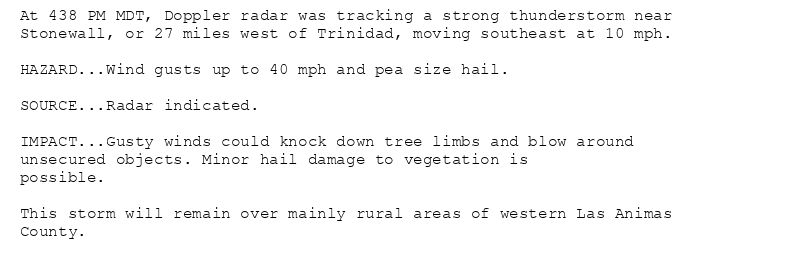
At 438 PM MDT, Doppler radar was tracking a strong thunderstorm near
Stonewall, or 27 miles west of Trinidad, moving southeast at 10 mph.
HAZARD...Wind gusts up to 40 mph and pea size hail.
SOURCE...Radar indicated.
IMPACT...Gusty winds could knock down tree limbs and blow around
unsecured objects. Minor hail damage to vegetation is
possible.
This storm will remain over mainly rural areas of western Las Animas
County.
Special Weather Statement issued August 11 at 4:38PM MDT by NWS Pueblo CO
Additional Details Here.
11.08.2025 22:45 — 👍 0 🔁 0 💬 0 📌 0
At 431 PM MDT, Doppler radar was tracking a strong thunderstorm 10
miles northeast of Eads, or 22 miles southwest of Cheyenne Wells,
moving southeast at 20 mph.
HAZARD...Wind gusts up to 50 mph and half inch hail.
SOURCE...Radar indicated.
IMPACT...Gusty winds could knock down tree limbs and blow around
unsecured objects. Minor hail damage to vegetation is
possible.
Locations impacted include...
Chivington.
Special Weather Statement issued August 11 at 4:32PM MDT by NWS Pueblo CO
Additional Details Here.
11.08.2025 22:45 — 👍 0 🔁 0 💬 0 📌 0
PUB issues A STRONG THUNDERSTORM WILL IMPACT SOUTHWESTERN BACA AND SOUTHEASTERN LAS ANIMAS COUNTIES THROUGH 345 PM MDT [wind: 50 MPH, hail: 0.50 IN] for Eastern Las Animas County,... at Mon, 11 Aug 2025 21:14:39 +0000 via IEMbot
Additional Details Here.
11.08.2025 21:27 — 👍 0 🔁 0 💬 0 📌 0
At 314 PM MDT, Doppler radar was tracking a strong thunderstorm 13
miles south of Kim, or 36 miles northeast of Des Moines, moving
southeast at 15 mph.
HAZARD...Wind gusts up to 50 mph and half inch hail.
SOURCE...Radar indicated.
IMPACT...Gusty winds could knock down tree limbs and blow around
unsecured objects. Minor hail damage to vegetation is
possible.
This storm will remain over mainly rural areas of southwestern Baca
and southeastern Las Animas Counties.
Special Weather Statement issued August 11 at 3:14PM MDT by NWS Pueblo CO
Additional Details Here.
11.08.2025 21:15 — 👍 0 🔁 0 💬 0 📌 0
PUB issues A STRONG THUNDERSTORM WILL IMPACT SOUTHWESTERN LAS ANIMAS COUNTY THROUGH 330 PM MDT [wind: 50 MPH, hail: 0.75 IN] for Southern Sangre De Cristo Mountains Between 7500 a... at Mon, 11 Aug 2025 20:55:21 +0000 via IEMbot
Additional Details Here.
11.08.2025 21:07 — 👍 0 🔁 0 💬 0 📌 0