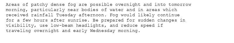
Areas of patchy dense fog are possible overnight and into tomorrow
morning, particularly near bodies of water and in areas which
received rainfall Tuesday afternoon. Fog would likely continue
for a few hours after sunrise. Be prepared for sudden changes in
visibility, use low-beam headlights, and reduce speed if
traveling overnight and early Wednesday morning.
Special Weather Statement issued August 5 at 11:30PM EDT by NWS Louisville KY
Additional Details Here.
06.08.2025 03:45 — 👍 0 🔁 0 💬 0 📌 0
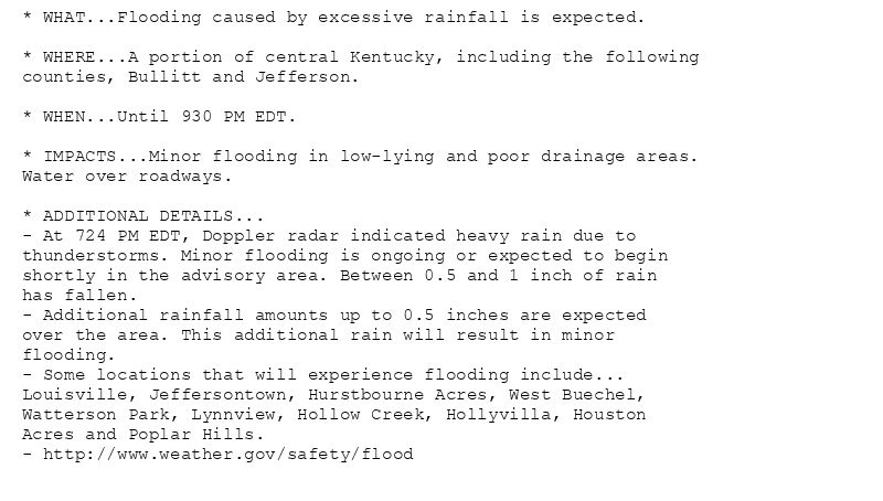
* WHAT...Flooding caused by excessive rainfall is expected.
* WHERE...A portion of central Kentucky, including the following
counties, Bullitt and Jefferson.
* WHEN...Until 930 PM EDT.
* IMPACTS...Minor flooding in low-lying and poor drainage areas.
Water over roadways.
* ADDITIONAL DETAILS...
- At 724 PM EDT, Doppler radar indicated heavy rain due to
thunderstorms. Minor flooding is ongoing or expected to begin
shortly in the advisory area. Between 0.5 and 1 inch of rain
has fallen.
- Additional rainfall amounts up to 0.5 inches are expected
over the area. This additional rain will result in minor
flooding.
- Some locations that will experience flooding include...
Louisville, Jeffersontown, Hurstbourne Acres, West Buechel,
Watterson Park, Lynnview, Hollow Creek, Hollyvilla, Houston
Acres and Poplar Hills.
- http://www.weather.gov/safety/flood
Flood Advisory issued August 5 at 7:24PM EDT until August 5 at 9:30PM EDT by NWS Louisville KY
Additional Details Here.
05.08.2025 23:30 — 👍 0 🔁 0 💬 0 📌 0
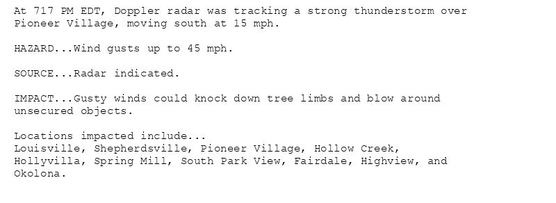
At 717 PM EDT, Doppler radar was tracking a strong thunderstorm over
Pioneer Village, moving south at 15 mph.
HAZARD...Wind gusts up to 45 mph.
SOURCE...Radar indicated.
IMPACT...Gusty winds could knock down tree limbs and blow around
unsecured objects.
Locations impacted include...
Louisville, Shepherdsville, Pioneer Village, Hollow Creek,
Hollyvilla, Spring Mill, South Park View, Fairdale, Highview, and
Okolona.
Special Weather Statement issued August 5 at 7:17PM EDT by NWS Louisville KY
Additional Details Here.
05.08.2025 23:30 — 👍 0 🔁 0 💬 0 📌 0

At 654 PM EDT, Doppler radar was tracking a strong thunderstorm over
Newburg, moving southeast at 15 mph.
HAZARD...Wind gusts up to 45 mph.
SOURCE...Radar indicated.
IMPACT...Gusty winds could knock down tree limbs and blow around
unsecured objects.
Locations impacted include...
Louisville, Jeffersontown, St. Matthews, Shively, Lyndon, Middletown,
Douglass Hills, Hurstbourne, Graymoor-Devondale, and Windy Hills.
Special Weather Statement issued August 5 at 6:54PM EDT by NWS Louisville KY
Additional Details Here.
05.08.2025 23:00 — 👍 0 🔁 0 💬 0 📌 0
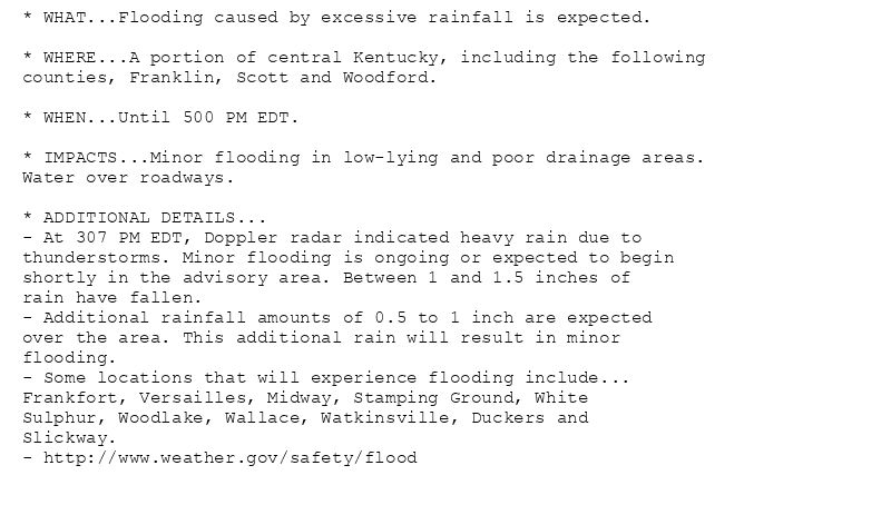
* WHAT...Flooding caused by excessive rainfall is expected.
* WHERE...A portion of central Kentucky, including the following
counties, Franklin, Scott and Woodford.
* WHEN...Until 500 PM EDT.
* IMPACTS...Minor flooding in low-lying and poor drainage areas.
Water over roadways.
* ADDITIONAL DETAILS...
- At 307 PM EDT, Doppler radar indicated heavy rain due to
thunderstorms. Minor flooding is ongoing or expected to begin
shortly in the advisory area. Between 1 and 1.5 inches of
rain have fallen.
- Additional rainfall amounts of 0.5 to 1 inch are expected
over the area. This additional rain will result in minor
flooding.
- Some locations that will experience flooding include...
Frankfort, Versailles, Midway, Stamping Ground, White
Sulphur, Woodlake, Wallace, Watkinsville, Duckers and
Slickway.
- http://www.weather.gov/safety/flood
Flood Advisory issued August 5 at 3:07PM EDT until August 5 at 5:00PM EDT by NWS Louisville KY
Additional Details Here.
05.08.2025 20:31 — 👍 0 🔁 0 💬 0 📌 0
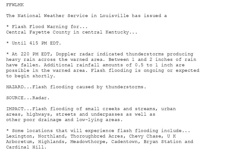
FFWLMK
The National Weather Service in Louisville has issued a
* Flash Flood Warning for...
Central Fayette County in central Kentucky...
* Until 415 PM EDT.
* At 220 PM EDT, Doppler radar indicated thunderstorms producing
heavy rain across the warned area. Between 1 and 2 inches of rain
have fallen. Additional rainfall amounts of 0.5 to 1 inch are
possible in the warned area. Flash flooding is ongoing or expected
to begin shortly.
HAZARD...Flash flooding caused by thunderstorms.
SOURCE...Radar.
IMPACT...Flash flooding of small creeks and streams, urban
areas, highways, streets and underpasses as well as
other poor drainage and low-lying areas.
* Some locations that will experience flash flooding include...
Lexington, Northland, Thoroughbred Acres, Chevy Chase, U K
Arboretum, Highlands, Meadowthorpe, Cadentown, Bryan Station and
Cardinal Hill.
🚨 Flash Flood Warning issued August 5 at 2:20PM EDT until August 5 at 4:15PM EDT by NWS Louisville KY 🚨
Additional Details Here.
05.08.2025 19:00 — 👍 0 🔁 0 💬 0 📌 0
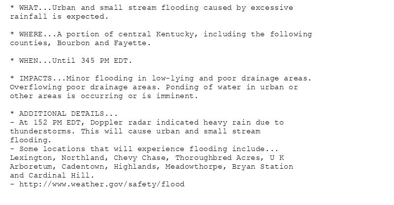
* WHAT...Urban and small stream flooding caused by excessive
rainfall is expected.
* WHERE...A portion of central Kentucky, including the following
counties, Bourbon and Fayette.
* WHEN...Until 345 PM EDT.
* IMPACTS...Minor flooding in low-lying and poor drainage areas.
Overflowing poor drainage areas. Ponding of water in urban or
other areas is occurring or is imminent.
* ADDITIONAL DETAILS...
- At 152 PM EDT, Doppler radar indicated heavy rain due to
thunderstorms. This will cause urban and small stream
flooding.
- Some locations that will experience flooding include...
Lexington, Northland, Chevy Chase, Thoroughbred Acres, U K
Arboretum, Cadentown, Highlands, Meadowthorpe, Bryan Station
and Cardinal Hill.
- http://www.weather.gov/safety/flood
Flood Advisory issued August 5 at 1:52PM EDT until August 5 at 3:45PM EDT by NWS Louisville KY
Additional Details Here.
05.08.2025 18:00 — 👍 0 🔁 0 💬 0 📌 0
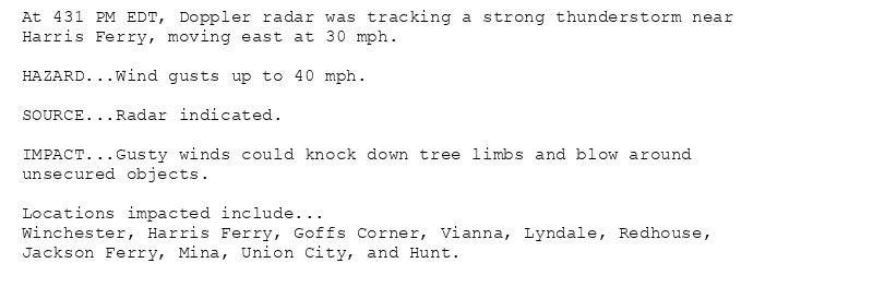
At 431 PM EDT, Doppler radar was tracking a strong thunderstorm near
Harris Ferry, moving east at 30 mph.
HAZARD...Wind gusts up to 40 mph.
SOURCE...Radar indicated.
IMPACT...Gusty winds could knock down tree limbs and blow around
unsecured objects.
Locations impacted include...
Winchester, Harris Ferry, Goffs Corner, Vianna, Lyndale, Redhouse,
Jackson Ferry, Mina, Union City, and Hunt.
Special Weather Statement issued July 31 at 4:31PM EDT by NWS Louisville KY
Additional Details Here.
31.07.2025 20:45 — 👍 0 🔁 0 💬 0 📌 0

* WHAT...Urban and small stream flooding caused by excessive
rainfall is expected.
* WHERE...A portion of central Kentucky, including the following
counties, Bourbon, Clark, Fayette and Madison.
* WHEN...Until 615 PM EDT.
* IMPACTS...Minor flooding in low-lying and poor drainage areas.
* ADDITIONAL DETAILS...
- At 411 PM EDT, Doppler radar indicated heavy rain due to
thunderstorms. This will cause urban and small stream
flooding.
- Some locations that will experience flooding include...
Winchester, Pinchem, Hunt, Haggard, Flanagan, Olivers, Elkin,
Lyndale, Bloomingdale and Forest Grove.
- http://www.weather.gov/safety/flood
Flood Advisory issued July 31 at 4:11PM EDT until July 31 at 6:15PM EDT by NWS Louisville KY
Additional Details Here.
31.07.2025 20:15 — 👍 0 🔁 0 💬 0 📌 0

At 347 PM EDT, Doppler radar was tracking a strong thunderstorm near
Nicholasville, moving southeast at 15 mph.
HAZARD...Wind gusts up to 40 mph and pea size hail.
SOURCE...Radar indicated.
IMPACT...Gusty winds could knock down tree limbs and blow around
unsecured objects. Minor hail damage to vegetation is
possible.
Locations impacted include...
Lexington, Nicholasville, Veterans Park, Fayette Mall, Spears,
Coletown, Valley View, Athens, Logana, and Union Mills.
Special Weather Statement issued July 31 at 3:47PM EDT by NWS Louisville KY
Additional Details Here.
31.07.2025 20:00 — 👍 1 🔁 0 💬 0 📌 0

At 245 PM CDT, Doppler radar was tracking a strong thunderstorm 9
miles north of Scottsville, moving southeast at 15 mph.
HAZARD...Wind gusts up to 40 mph and pea size hail.
SOURCE...Radar indicated.
IMPACT...Gusty winds could knock down tree limbs and blow around
unsecured objects. Minor hail damage to vegetation is
possible.
Locations impacted include...
Scottsville, Three Forks, Maynard, Lucas, Austin, Settle, Yesse,
Raley Ford, Halifax, and Claypool.
Special Weather Statement issued July 31 at 2:45PM CDT by NWS Louisville KY
Additional Details Here.
31.07.2025 20:00 — 👍 1 🔁 0 💬 0 📌 0
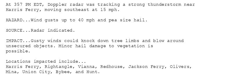
At 357 PM EDT, Doppler radar was tracking a strong thunderstorm near
Harris Ferry, moving southeast at 15 mph.
HAZARD...Wind gusts up to 40 mph and pea size hail.
SOURCE...Radar indicated.
IMPACT...Gusty winds could knock down tree limbs and blow around
unsecured objects. Minor hail damage to vegetation is
possible.
Locations impacted include...
Harris Ferry, Rightangle, Vianna, Redhouse, Jackson Ferry, Olivers,
Mina, Union City, Bybee, and Hunt.
Special Weather Statement issued July 31 at 3:57PM EDT by NWS Louisville KY
Additional Details Here.
31.07.2025 20:00 — 👍 0 🔁 0 💬 0 📌 0

At 337 PM EDT, Doppler radar was tracking a strong thunderstorm 11
miles east of Campbellsville, moving southeast at 15 mph.
HAZARD...Wind gusts up to 40 mph.
SOURCE...Radar indicated.
IMPACT...Gusty winds could knock down tree limbs and blow around
unsecured objects.
Locations impacted include...
Bass, Creston, Atterson, Clementsville, and Merrimac.
Special Weather Statement issued July 31 at 3:37PM EDT by NWS Louisville KY
Additional Details Here.
31.07.2025 19:45 — 👍 0 🔁 0 💬 0 📌 0
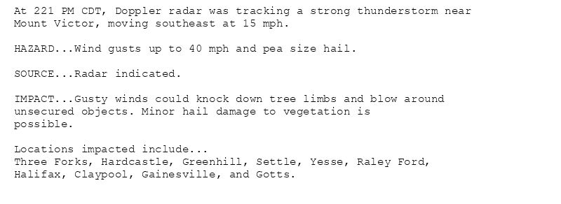
At 221 PM CDT, Doppler radar was tracking a strong thunderstorm near
Mount Victor, moving southeast at 15 mph.
HAZARD...Wind gusts up to 40 mph and pea size hail.
SOURCE...Radar indicated.
IMPACT...Gusty winds could knock down tree limbs and blow around
unsecured objects. Minor hail damage to vegetation is
possible.
Locations impacted include...
Three Forks, Hardcastle, Greenhill, Settle, Yesse, Raley Ford,
Halifax, Claypool, Gainesville, and Gotts.
Special Weather Statement issued July 31 at 2:21PM CDT by NWS Louisville KY
Additional Details Here.
31.07.2025 19:30 — 👍 0 🔁 0 💬 0 📌 0
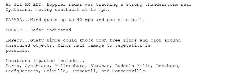
At 311 PM EDT, Doppler radar was tracking a strong thunderstorm near
Cynthiana, moving southeast at 15 mph.
HAZARD...Wind gusts up to 40 mph and pea size hail.
SOURCE...Radar indicated.
IMPACT...Gusty winds could knock down tree limbs and blow around
unsecured objects. Minor hail damage to vegetation is
possible.
Locations impacted include...
Paris, Cynthiana, Millersburg, Shawhan, Ruddels Mills, Leesburg,
Headquarters, Colville, Broadwell, and Connersville.
Special Weather Statement issued July 31 at 3:11PM EDT by NWS Louisville KY
Additional Details Here.
31.07.2025 19:15 — 👍 0 🔁 0 💬 0 📌 0
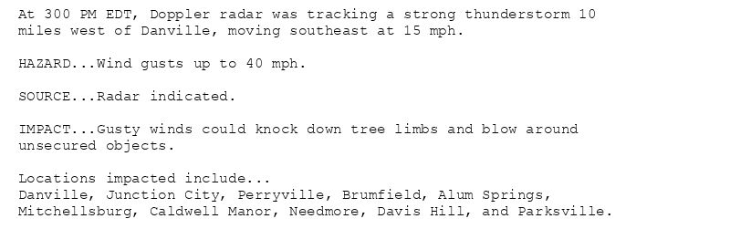
At 300 PM EDT, Doppler radar was tracking a strong thunderstorm 10
miles west of Danville, moving southeast at 15 mph.
HAZARD...Wind gusts up to 40 mph.
SOURCE...Radar indicated.
IMPACT...Gusty winds could knock down tree limbs and blow around
unsecured objects.
Locations impacted include...
Danville, Junction City, Perryville, Brumfield, Alum Springs,
Mitchellsburg, Caldwell Manor, Needmore, Davis Hill, and Parksville.
Special Weather Statement issued July 31 at 3:00PM EDT by NWS Louisville KY
Additional Details Here.
31.07.2025 19:15 — 👍 0 🔁 0 💬 0 📌 0
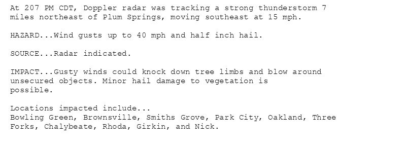
At 207 PM CDT, Doppler radar was tracking a strong thunderstorm 7
miles northeast of Plum Springs, moving southeast at 15 mph.
HAZARD...Wind gusts up to 40 mph and half inch hail.
SOURCE...Radar indicated.
IMPACT...Gusty winds could knock down tree limbs and blow around
unsecured objects. Minor hail damage to vegetation is
possible.
Locations impacted include...
Bowling Green, Brownsville, Smiths Grove, Park City, Oakland, Three
Forks, Chalybeate, Rhoda, Girkin, and Nick.
Special Weather Statement issued July 31 at 2:07PM CDT by NWS Louisville KY
Additional Details Here.
31.07.2025 19:15 — 👍 0 🔁 0 💬 0 📌 0

At 142 PM CDT, Doppler radar was tracking a strong thunderstorm over
Morgantown, moving southeast at 20 mph.
HAZARD...Wind gusts up to 40 mph.
SOURCE...Radar indicated.
IMPACT...Gusty winds could knock down tree limbs and blow around
unsecured objects.
Locations impacted include...
Morgantown, Woodbury, Monford, Roundhill, Banock, Mining City,
Aberdeen, Flener, Eden, and Benleo.
Special Weather Statement issued July 31 at 1:43PM CDT by NWS Louisville KY
Additional Details Here.
31.07.2025 18:45 — 👍 1 🔁 0 💬 0 📌 0
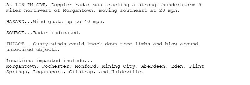
At 123 PM CDT, Doppler radar was tracking a strong thunderstorm 9
miles northwest of Morgantown, moving southeast at 20 mph.
HAZARD...Wind gusts up to 40 mph.
SOURCE...Radar indicated.
IMPACT...Gusty winds could knock down tree limbs and blow around
unsecured objects.
Locations impacted include...
Morgantown, Rochester, Monford, Mining City, Aberdeen, Eden, Flint
Springs, Logansport, Gilstrap, and Huldeville.
Special Weather Statement issued July 31 at 1:23PM CDT by NWS Louisville KY
Additional Details Here.
31.07.2025 18:30 — 👍 0 🔁 0 💬 0 📌 0
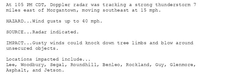
At 105 PM CDT, Doppler radar was tracking a strong thunderstorm 7
miles east of Morgantown, moving southeast at 15 mph.
HAZARD...Wind gusts up to 40 mph.
SOURCE...Radar indicated.
IMPACT...Gusty winds could knock down tree limbs and blow around
unsecured objects.
Locations impacted include...
Lee, Woodbury, Segal, Roundhill, Benleo, Rockland, Guy, Glenmore,
Asphalt, and Jetson.
Special Weather Statement issued July 31 at 1:05PM CDT by NWS Louisville KY
Additional Details Here.
31.07.2025 18:15 — 👍 0 🔁 0 💬 0 📌 0
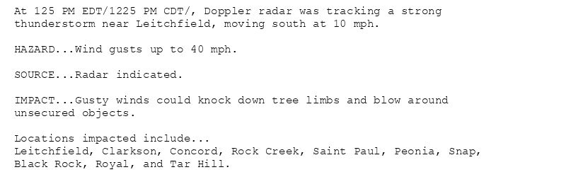
At 125 PM EDT/1225 PM CDT/, Doppler radar was tracking a strong
thunderstorm near Leitchfield, moving south at 10 mph.
HAZARD...Wind gusts up to 40 mph.
SOURCE...Radar indicated.
IMPACT...Gusty winds could knock down tree limbs and blow around
unsecured objects.
Locations impacted include...
Leitchfield, Clarkson, Concord, Rock Creek, Saint Paul, Peonia, Snap,
Black Rock, Royal, and Tar Hill.
Special Weather Statement issued July 31 at 1:25PM EDT by NWS Louisville KY
Additional Details Here.
31.07.2025 17:30 — 👍 0 🔁 0 💬 0 📌 0
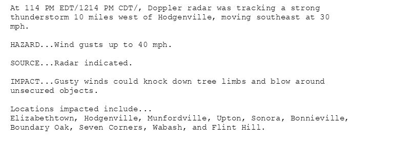
At 114 PM EDT/1214 PM CDT/, Doppler radar was tracking a strong
thunderstorm 10 miles west of Hodgenville, moving southeast at 30
mph.
HAZARD...Wind gusts up to 40 mph.
SOURCE...Radar indicated.
IMPACT...Gusty winds could knock down tree limbs and blow around
unsecured objects.
Locations impacted include...
Elizabethtown, Hodgenville, Munfordville, Upton, Sonora, Bonnieville,
Boundary Oak, Seven Corners, Wabash, and Flint Hill.
Special Weather Statement issued July 31 at 1:15PM EDT by NWS Louisville KY
Additional Details Here.
31.07.2025 17:30 — 👍 0 🔁 0 💬 0 📌 0

At 1251 PM EDT, Doppler radar was tracking a strong thunderstorm over
Elizabethtown, moving southeast at 20 mph.
HAZARD...Wind gusts up to 50 mph.
SOURCE...Radar indicated.
IMPACT...Gusty winds could knock down tree limbs and blow around
unsecured objects.
Locations impacted include...
Elizabethtown, Hodgenville, Radcliff, Sonora, Cecilia, Hansbrough,
Roanoke, Addington Field Airport, Glendale, and Nolin.
Special Weather Statement issued July 31 at 12:51PM EDT by NWS Louisville KY
Additional Details Here.
31.07.2025 17:00 — 👍 0 🔁 0 💬 0 📌 0
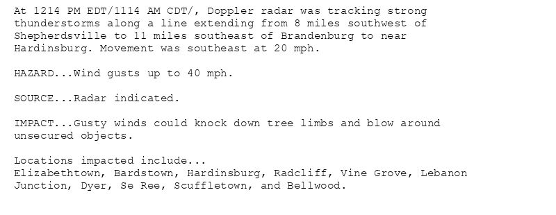
At 1214 PM EDT/1114 AM CDT/, Doppler radar was tracking strong
thunderstorms along a line extending from 8 miles southwest of
Shepherdsville to 11 miles southeast of Brandenburg to near
Hardinsburg. Movement was southeast at 20 mph.
HAZARD...Wind gusts up to 40 mph.
SOURCE...Radar indicated.
IMPACT...Gusty winds could knock down tree limbs and blow around
unsecured objects.
Locations impacted include...
Elizabethtown, Bardstown, Hardinsburg, Radcliff, Vine Grove, Lebanon
Junction, Dyer, Se Ree, Scuffletown, and Bellwood.
Special Weather Statement issued July 31 at 12:15PM EDT by NWS Louisville KY
Additional Details Here.
31.07.2025 16:30 — 👍 0 🔁 0 💬 0 📌 0

At 1133 AM EDT/1033 AM CDT/, Doppler radar was tracking a cluster of
strong thunderstorms along a line extending from 9 miles east of
Brandenburg to 8 miles northwest of Hardinsburg. Movement was
southeast at 20 mph.
HAZARD...Wind gusts up to 40 mph.
SOURCE...Radar indicated.
IMPACT...Gusty winds could knock down tree limbs and blow around
unsecured objects.
Locations impacted include...
Shepherdsville, Brandenburg, Hardinsburg, Valley Station, Radcliff,
Webster, Vine Grove, Lebanon Junction, Irvington, and Muldraugh.
Special Weather Statement issued July 31 at 11:33AM EDT by NWS Louisville KY
Additional Details Here.
31.07.2025 15:45 — 👍 1 🔁 0 💬 0 📌 0
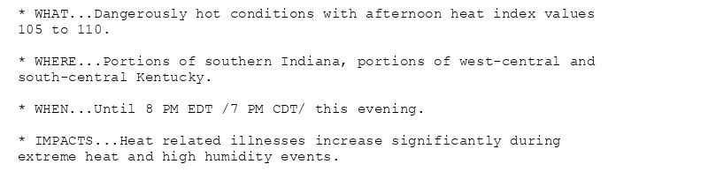
* WHAT...Dangerously hot conditions with afternoon heat index values
105 to 110.
* WHERE...Portions of southern Indiana, portions of west-central and
south-central Kentucky.
* WHEN...Until 8 PM EDT /7 PM CDT/ this evening.
* IMPACTS...Heat related illnesses increase significantly during
extreme heat and high humidity events.
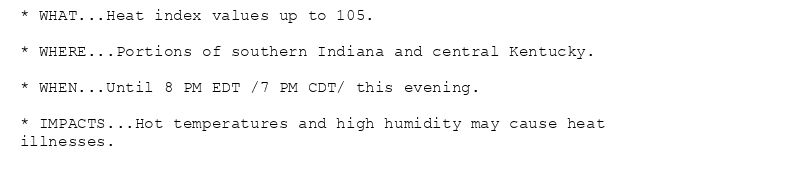
* WHAT...Heat index values up to 105.
* WHERE...Portions of southern Indiana and central Kentucky.
* WHEN...Until 8 PM EDT /7 PM CDT/ this evening.
* IMPACTS...Hot temperatures and high humidity may cause heat
illnesses.
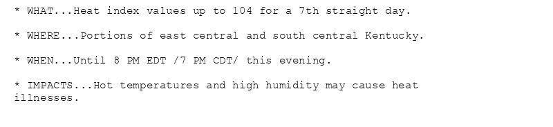
* WHAT...Heat index values up to 104 for a 7th straight day.
* WHERE...Portions of east central and south central Kentucky.
* WHEN...Until 8 PM EDT /7 PM CDT/ this evening.
* IMPACTS...Hot temperatures and high humidity may cause heat
illnesses.
🚨 Extreme Heat Warning issued July 30 at 5:19AM EDT until July 30 at 8:00PM EDT by NWS Louisville KY 🚨
Additional Details Here.
30.07.2025 09:30 — 👍 1 🔁 0 💬 0 📌 0
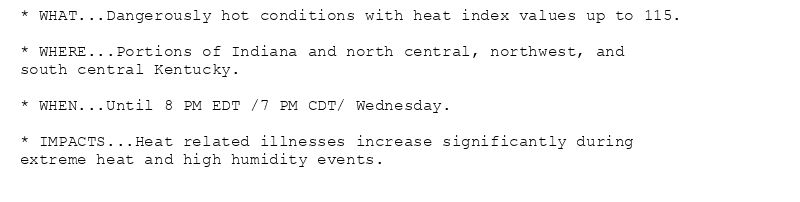
* WHAT...Dangerously hot conditions with heat index values up to 115.
* WHERE...Portions of Indiana and north central, northwest, and
south central Kentucky.
* WHEN...Until 8 PM EDT /7 PM CDT/ Wednesday.
* IMPACTS...Heat related illnesses increase significantly during
extreme heat and high humidity events.

* WHAT...Heat index values up to 108.
* WHERE...Portions of south central Indiana and east central, north
central, and south central Kentucky.
* WHEN...Until 8 PM EDT /7 PM CDT/ Wednesday.
* IMPACTS...Hot temperatures and high humidity may cause heat
illnesses.

* WHAT...Heat index values up to 106.
* WHERE...Portions of east central and south central Kentucky.
* WHEN...Until 8 PM EDT /7 PM CDT/ Wednesday.
* IMPACTS...Hot temperatures and high humidity may cause heat
illnesses.
🚨 Extreme Heat Warning issued July 29 at 8:10PM EDT until July 30 at 8:00PM EDT by NWS Louisville KY 🚨
Additional Details Here.
30.07.2025 00:15 — 👍 0 🔁 0 💬 0 📌 0
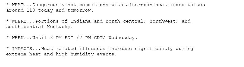
* WHAT...Dangerously hot conditions with afternoon heat index values
around 110 today and tomorrow.
* WHERE...Portions of Indiana and north central, northwest, and
south central Kentucky.
* WHEN...Until 8 PM EDT /7 PM CDT/ Wednesday.
* IMPACTS...Heat related illnesses increase significantly during
extreme heat and high humidity events.
* WHAT...Heat index values up to 108.
* WHERE...Portions of south central Indiana and east central, north
central, and south central Kentucky.
* WHEN...Until 8 PM EDT /7 PM CDT/ Wednesday.
* IMPACTS...Hot temperatures and high humidity may cause heat
illnesses.
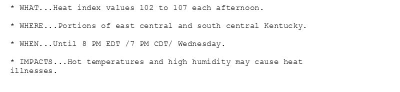
* WHAT...Heat index values 102 to 107 each afternoon.
* WHERE...Portions of east central and south central Kentucky.
* WHEN...Until 8 PM EDT /7 PM CDT/ Wednesday.
* IMPACTS...Hot temperatures and high humidity may cause heat
illnesses.
🚨 Extreme Heat Warning issued July 29 at 3:04PM EDT until July 30 at 8:00PM EDT by NWS Louisville KY 🚨
Additional Details Here.
29.07.2025 19:46 — 👍 1 🔁 0 💬 0 📌 0
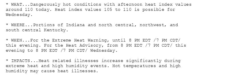
* WHAT...Dangerously hot conditions with afternoon heat index values
around 110 today. Heat index values 105 to 110 is possible for
Wednesday.
* WHERE...Portions of Indiana and north central, northwest, and
south central Kentucky.
* WHEN...For the Extreme Heat Warning, until 8 PM EDT /7 PM CDT/
this evening. For the Heat Advisory, from 8 PM EDT /7 PM CDT/ this
evening to 8 PM EDT /7 PM CDT/ Wednesday.
* IMPACTS...Heat related illnesses increase significantly during
extreme heat and high humidity events. Hot temperatures and high
humidity may cause heat illnesses.
* WHAT...Heat index values 102 to 107 each afternoon.
* WHERE...Portions of south central Indiana and east central, north
central, and south central Kentucky.
* WHEN...Until 8 PM EDT /7 PM CDT/ Wednesday.
* IMPACTS...Hot temperatures and high humidity may cause heat
illnesses.
* WHAT...Heat index values 102 to 107 each afternoon.
* WHERE...Portions of east central and south central Kentucky.
* WHEN...Until 8 PM EDT /7 PM CDT/ Wednesday.
* IMPACTS...Hot temperatures and high humidity may cause heat
illnesses.
🚨 Heat Advisory issued July 29 at 8:11AM EDT until July 30 at 8:00PM EDT by NWS Louisville KY 🚨
Additional Details Here.(1/2)
29.07.2025 12:28 — 👍 2 🔁 0 💬 0 📌 0

* WHAT...Dangerously hot conditions with afternoon heat index values
around 110.
* WHERE...Portions of Indiana and north central, northwest, and
south central Kentucky.
* WHEN...Until 8 PM EDT /7 PM CDT/ this evening.
* IMPACTS...Heat related illnesses increase significantly during
extreme heat and high humidity events.
* WHAT...Heat index values 102 to 107 each afternoon.
* WHERE...Portions of south central Indiana and east central, north
central, and south central Kentucky.
* WHEN...Until 8 PM EDT /7 PM CDT/ Wednesday.
* IMPACTS...Hot temperatures and high humidity may cause heat
illnesses.
* WHAT...Heat index values 102 to 107 each afternoon.
* WHERE...Portions of east central and south central Kentucky.
* WHEN...Until 8 PM EDT /7 PM CDT/ Wednesday.
* IMPACTS...Hot temperatures and high humidity may cause heat
illnesses.
🚨 Extreme Heat Warning issued July 29 at 7:56AM EDT until July 29 at 8:00PM EDT by NWS Louisville KY 🚨
Additional Details Here.
29.07.2025 12:08 — 👍 1 🔁 0 💬 0 📌 0