Watching Taylor Swift pull out #TSTheLifeOfaShowgirl and talk about how she wrote this on #TSTheErasTour and her motivation for #TS12 is just amazing! To quote her… None of this was accidental… because you’re a Mastermind! 🧡🧡🧡
14.08.2025 00:38 — 👍 2 🔁 0 💬 0 📌 0

And here it is! The Life of a Showgirl, Taylor Swift’s New Album will be released on October 3rd, 2025! If you’re curious, there’s over 750,000 people watching the premiere of the latest episode of the New Heights Podcast on YouTube, with Taylor as the special guest! #TSTheLifeOfAShowgirl #TS12 🧡🧡🧡
13.08.2025 23:12 — 👍 1 🔁 0 💬 0 📌 0
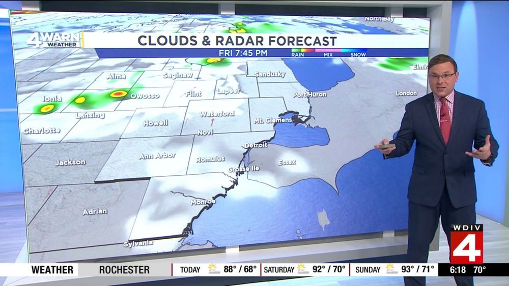
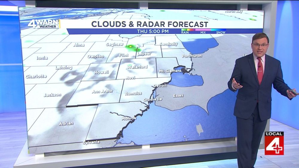
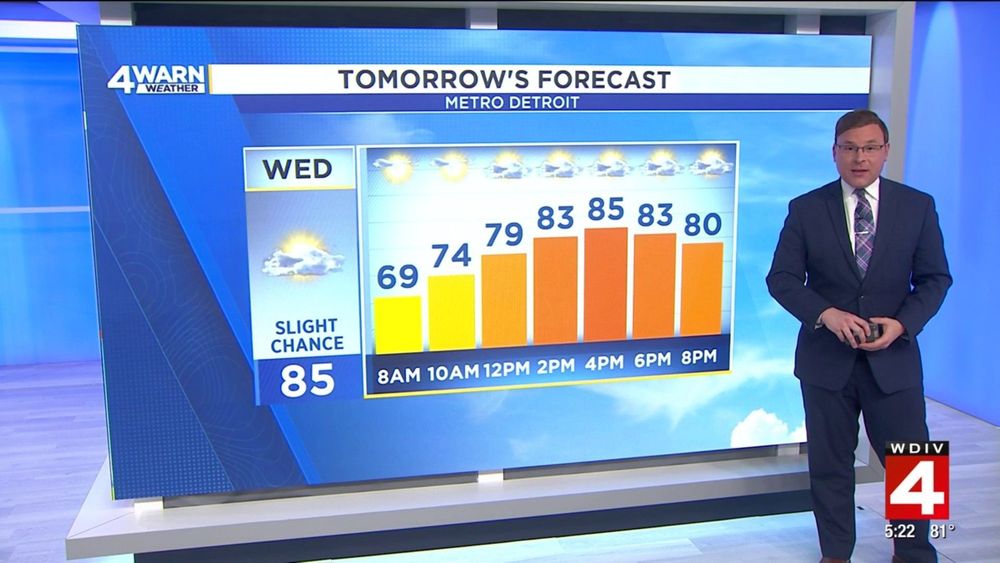
After the cold front has rolled through the region, we are keeping some of the cloud cover into the forecast for the start of the day. While we are expecting mostly cloudy skies this morning, expect a decrease in clouds late morning and into the afternoon.. #MIWX
13.08.2025 14:48 — 👍 0 🔁 0 💬 0 📌 0
Oh, and did anyone spot me wearing one of my Orange Ties tonight at 11:00 PM in honor of Taylor Swift announcing #TS12 #TSTheLifeOfAShowGirl being announced?!?! Let's go, Taylor!! We've been waiting for this!! 🧡🧡🧡
13.08.2025 03:30 — 👍 4 🔁 0 💬 0 📌 0
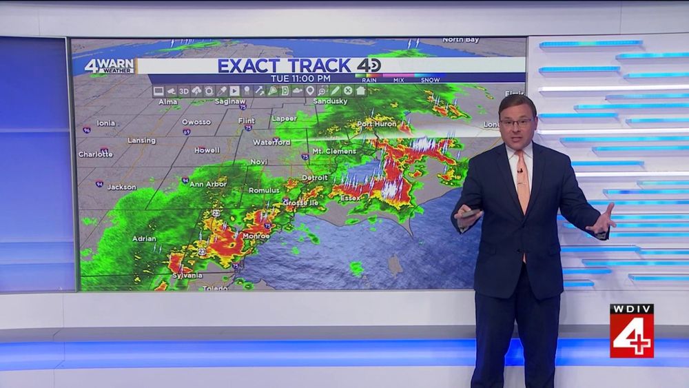
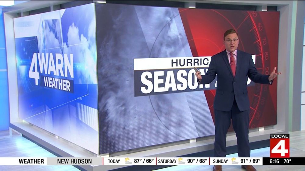
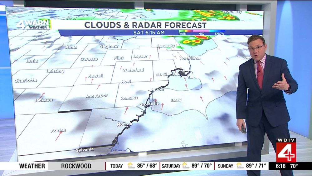
Back in the studio, weather leading the 11:00 PM News tonight as we're tracking showers and thunderstorms moving through the region. Some of them have been on the stronger side, but the cold front moves through tonight, bringing an end to the storms & a break from the humidity.. #MIWX
13.08.2025 03:05 — 👍 1 🔁 0 💬 0 📌 0
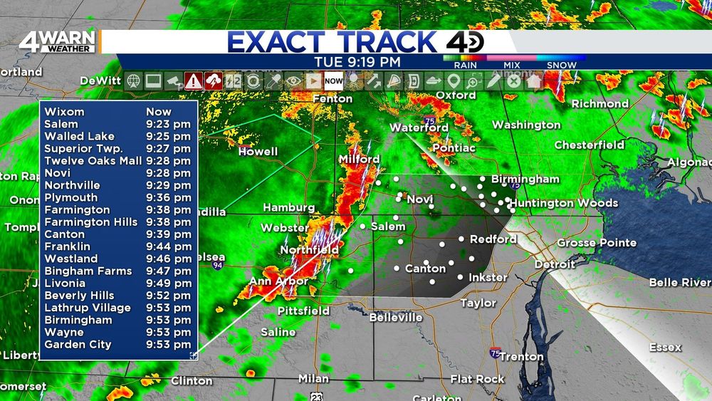
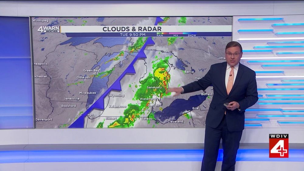
STRONG THUNDERSTORMS: Moving into portions of Oakland, Wayne and Washtenaw Counties within the next 45-60 Minutes. This line of storms could produce winds to 50 MPH as it moves to the East at 25 MPH. Be alert for heavy rainfall, gusty winds and frequent lightning through 10:30 PM... #MIWX
13.08.2025 01:21 — 👍 1 🔁 0 💬 0 📌 0
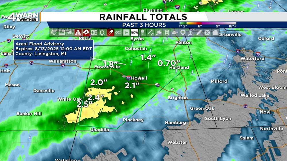
FLOOD ADVISORY: Livingston County, MI until Midnight Wednesday Morning... Exact Track 4D Radar is indicating that Central and Southwestern Livingston County has seen as much as 2" of rainfall. Another 0.5"-1.0" is possible, so some minor flooding is possible in this area.. #MIWX
13.08.2025 01:06 — 👍 0 🔁 0 💬 0 📌 0
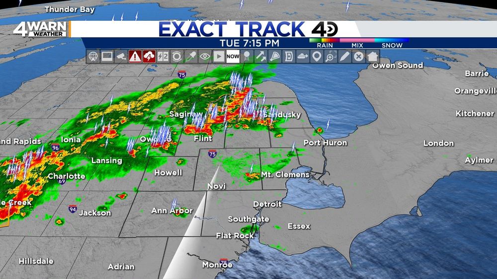
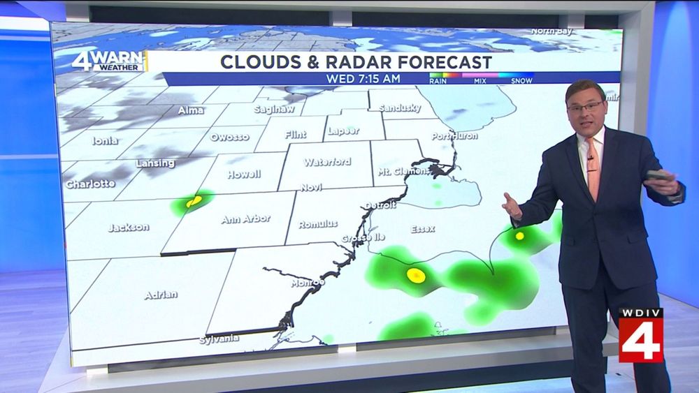
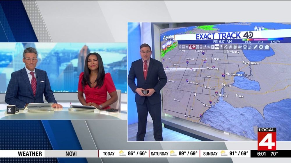
EXACT TRACK 4D RADAR (7:15 PM 8/12/25): A scattered patchwork of showers and thunderstorms across the region continue. All of the warnings we have had in effect have expired or cancelled, but we still could see some strong/severe storms tonight. Towercam shows the tall thunderstorms.. #MIWX
12.08.2025 23:18 — 👍 1 🔁 1 💬 0 📌 0
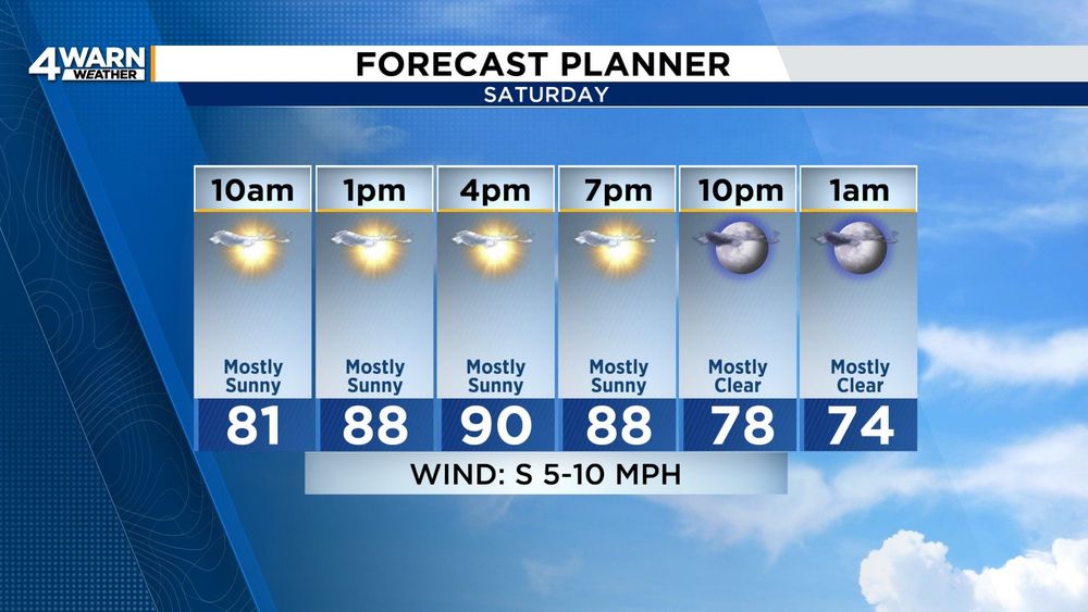
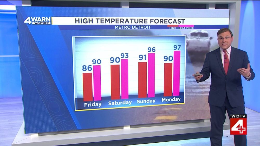
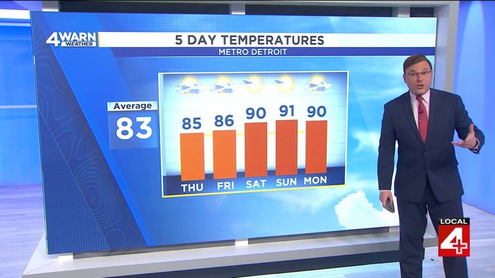
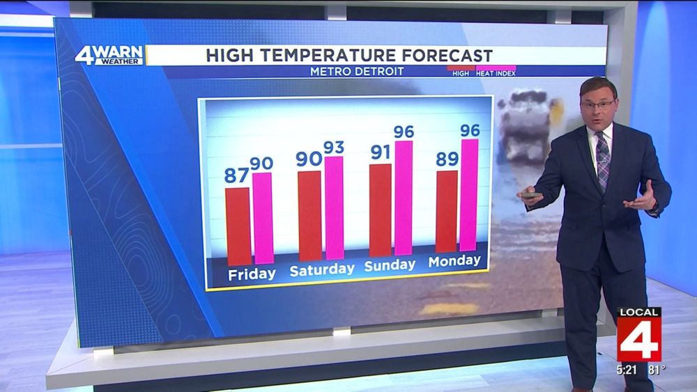
SATURDAY FORECAST: Expect plenty of sunshine throughout the day, and it will be hot and humid to start the weekend as well. Temperatures into the 80s by mid morning, heading into the lower 90s this afternoon with heat index values into the mid upper 90s for everybody... #MIWX
09.08.2025 12:59 — 👍 0 🔁 0 💬 0 📌 0
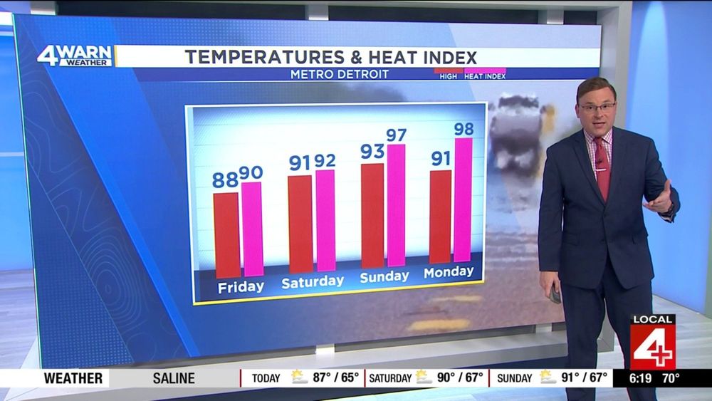
90° HEAT INDEX VALUES: Return to the forecast starting today (Friday), and continuing through the entire weekend and into the start of next week. It will feel as warm as the mid to upper 90s by the end of the weekend on Sunday, and into the beginning of next week on Monday.. #MIWX
08.08.2025 18:25 — 👍 0 🔁 0 💬 0 📌 0
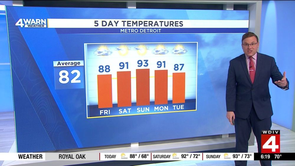
CONTINUING HEAT & HUMIDITY: We're into the 80s today, then into the lower 90s for the entire weekend and into the start of next week. Expect plenty of sunshine as we work through Saturday and Sunday, then we will start to bring the storm chances into the forecast early next week.. #MIWX
08.08.2025 17:26 — 👍 0 🔁 0 💬 0 📌 0
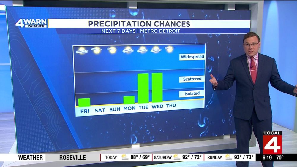
RAIN & STORM CHANCES: Outside of an isolated storm today, we really don't bring significant rain and thunderstorm chances into the forecast until the start of next week. Storm chances ramp up late Monday night, then storm chances continue into Tuesday and Wednesday... #MIWX
08.08.2025 16:25 — 👍 0 🔁 0 💬 0 📌 0
Looking ahead into early Saturday Morning, we may see a little more cloud cover overnight that I was originally thinking. But, the data now suggests that we could see a line of decaying thunderstorms move through Central/Northern Michigan, that may bring an isolated storm to the thumb overnight...
08.08.2025 15:26 — 👍 0 🔁 0 💬 0 📌 0
As we head through the afternoon and into the early evening hours, we will be watching the radar for another round of an isolated thunderstorm or two. This will not be widespread, most places will remain dry, but especially North and West of the Metro, one or two storms are possible.. #MIWX
08.08.2025 13:25 — 👍 0 🔁 0 💬 0 📌 0
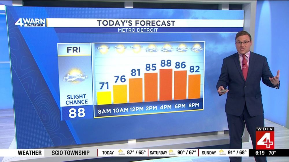
FRIDAY FORECAST: 70s out the door in the morning, warming into the upper 80s by the time we get to the weekend. Sunshine brings a little more cloud cover by the afternoon, and the chance for an isolated thunderstorm as well, but most places remain dry. Feeling like its close to 90° today...
08.08.2025 12:55 — 👍 0 🔁 0 💬 0 📌 0
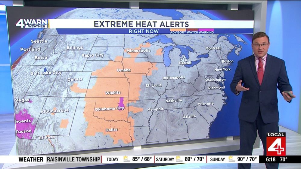
SUMMER HEAT RETURNS: Heat Advisories going up all across the Midwestern United States for today and into the weekend. A few Extreme Heat Warnings are up as well. While we're not expecting these in Metro Detroit, we will see more heat & more humidity starting Friday and into the weekend.. #MIWX
08.08.2025 12:19 — 👍 0 🔁 0 💬 0 📌 0
We're starting off our Friday with some sunshine, and continuing a little bit of haze in the atmosphere as well due to the smoke from the Canadian wildfires still lingering. But, it is definitely warmer than it's been the last few mornings. 70s out the door, so get the air conditioning running!
08.08.2025 11:04 — 👍 1 🔁 0 💬 0 📌 0
A very nice sunrise outside this morning as we're taking a live look outside our Towercam over Belle Isle this morning. A little haze on the horizon as well this morning. So, grab the sunglasses, we'll need them as we head through the day, also the air conditioning as well! #MIWX
08.08.2025 10:48 — 👍 1 🔁 0 💬 0 📌 0
Good Friday Morning!! In for Ashlee on the morning show this morning! It's been a minute since I have been on weekday mornings, as I've been floating over to the weeknights to fill in for Kim! So glad to be with Rhonda and Jason as we talk about summer heat and humidity moving in shortly...
08.08.2025 10:04 — 👍 1 🔁 0 💬 0 📌 0
HOT & HUMID AHEAD: While we're forecasting temperatures to warm back up into the 90s again this weekend, the humidity increases as well. Expect heat index values at 90° or better starting on Friday, and going as high as the mid to upper 90s from Sunday and into next Monday.. #MIWX
07.08.2025 14:25 — 👍 0 🔁 0 💬 0 📌 0
SLOWLY GETTING WARMER: Temperatures close to where we should be for early August over the next few days. But, summer isn't done just yet... We've got 90s back on tap for the upcoming weekend and into early next week as well. No rain chances showing up Saturday through Monday too.. #MIWX
07.08.2025 13:26 — 👍 1 🔁 1 💬 0 📌 0
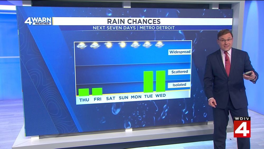
SLIM RAIN CHANCES AHEAD: Our cold front we talked about for Monday looks to be slowing down a bit, so we've shifted the rain chances back about 24 hours for the start of next week. A slight chance of a shower or storm today & Friday, but no real decent rain chances soon.. #MIWX
07.08.2025 12:26 — 👍 0 🔁 0 💬 0 📌 0
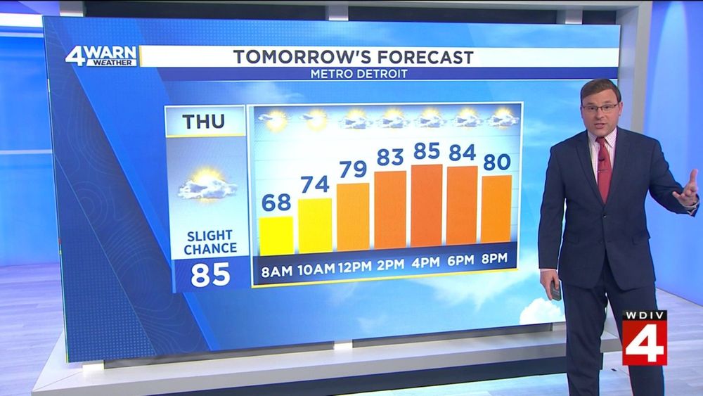
THURSDAY FORECAST: Sunshine to start the day before a little more cloud cover works in by the afternoon. While most places stay dry, we do continue the slight chance of a shower or thunderstorm in the afternoon & early evening. 60s this morning, near 80° by lunchtime, mid 80s for a daytime high..
07.08.2025 11:25 — 👍 0 🔁 0 💬 0 📌 0
While most of us remained dry throughout the day on Wednesday, we did have a few showers or isolated storms develop mid-late afternoon, and I am expecting much of the same looking ahead into Thursday. Again, not widespread, but we'll be watching the radar! #MIWX
07.08.2025 10:26 — 👍 1 🔁 0 💬 0 📌 0
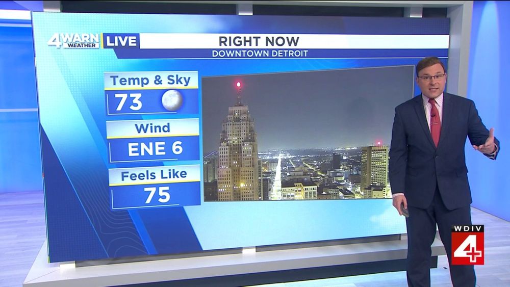
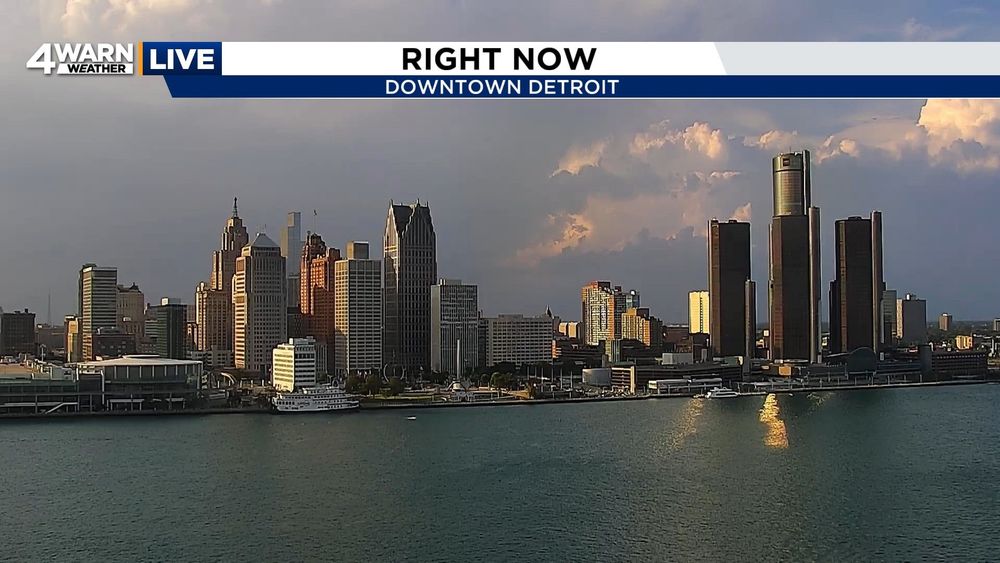
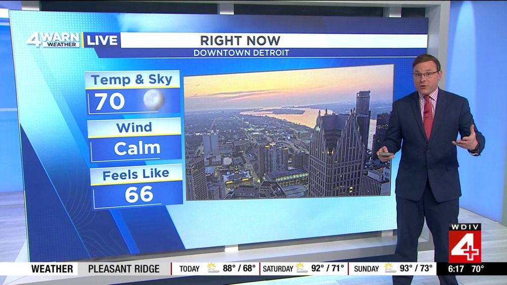
Despite the clearing skies into the late evening hours tonight, we can still see some haze on the horizon over Downtown Detroit, even at 11:00 PM at night! 70s for most everyone tonight, and it will remain comfortable overnight... #MIWX #4WarnWeather
07.08.2025 04:26 — 👍 0 🔁 0 💬 0 📌 0
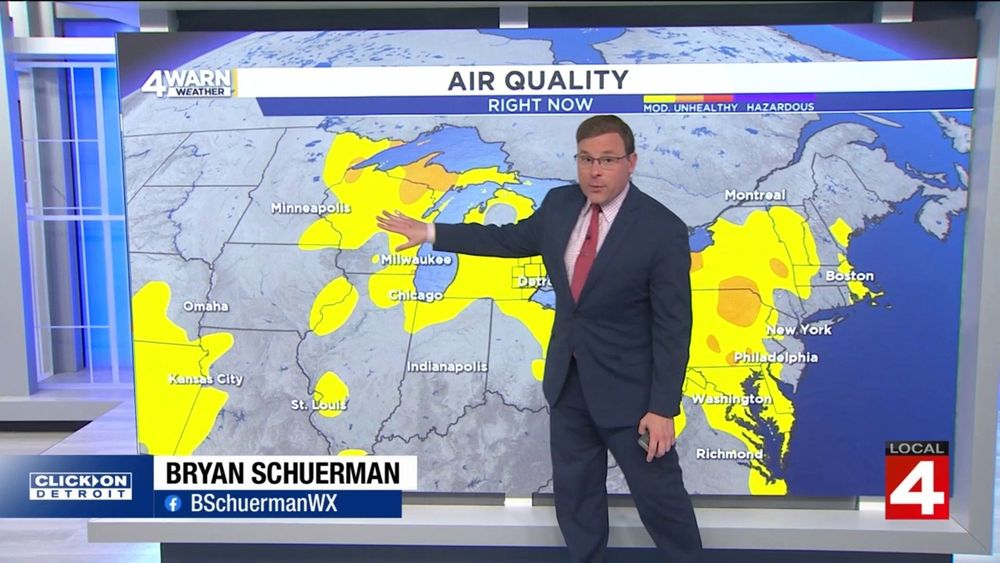
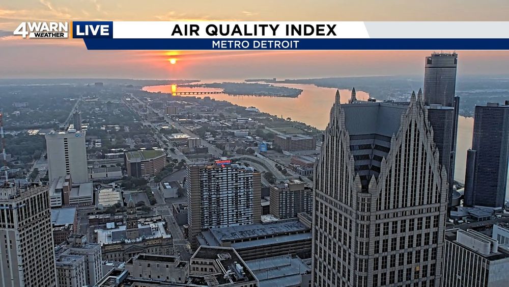
Back in studio for the late night news on Wednesday, as we're still talking poor air quality issues across the region. Moderate range for all of Southeastern Michigan tonight, and we're going to keep the moderate air quality around into our Thursday as well.. #MIWX
07.08.2025 03:49 — 👍 0 🔁 0 💬 0 📌 0
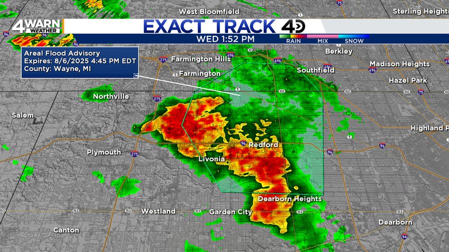
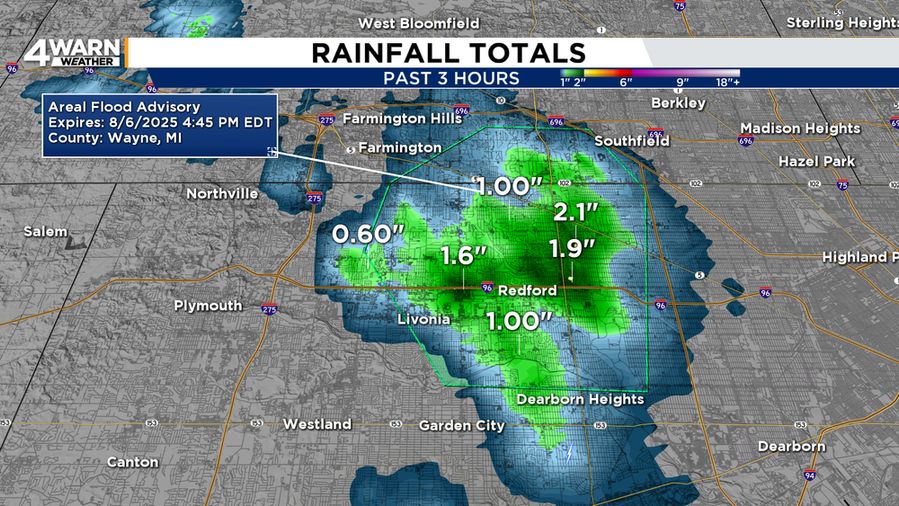
FLOOD ADVISORY: Oakland & Wayne Counties, MI until 4:45 PM. As a few of these showers/thunderstorms have developed, this one is putting down some heavy rainfall with 1-2" of rain in the advisory. Another 0.5"-1" could be possible which could cause minor flooding.. #MIWX
06.08.2025 17:56 — 👍 1 🔁 0 💬 0 📌 0
WEDNESDAY FORECAST: We keep the sunshine and some clouds into the forecast looking ahead into Wednesday. Holding onto an isolated shower, but I do think, much like we had on Tuesday, 99% of the region remains dry. 70s by lunchtime, 80s by the afternoon... #MIWX
06.08.2025 10:11 — 👍 2 🔁 0 💬 0 📌 0
HEAT AND HUMIDITY RETURN: Enjoy these lower 80s, we're dialing up more heat and more humidity by the end of the week and looking ahead into the weekend. 90s are on the way for Saturday and Sunday, but 90° heat index values arrive starting on Friday... #MIWX
06.08.2025 03:10 — 👍 0 🔁 0 💬 0 📌 0
I’m not messy, I’m busy. Happily married to @team-edward.bsky.social. Queer. Trans rights are human rights. (He/Him)
The Michigan Parent, Advocate & Attorney Coalition (MiPAAC) is a statewide group focused on student-centered advocacy to improve access to educational outcomes for students with disabilities.
https://mipaac.org/
I’m a lead teacher for a local school system who loves traveling, the outdoors, anything horror, video/trivia games, progressive values, spending time with friends/family, and living life to the fullest!
U.S. Congressman serving my hometown #IL17. TV Meteorologist/climate guy for 22+ years. (Personal/Campaign Account) 🇺🇸🏳️🌈🌎
Multidisciplinary artist/community catalyst living in Seattle, WA. Leadership at Seattle Gaymers, Intiman Theatre, Pride ASIA, & MEN IN DANCE.
https://instagram.com/thislilgecko
https://modelmayhem.com/kince
https://www.linkedin.com/in/kince
🇵🇭✡️🏳️🌈
Tune in Mondays through Fridays at 7pm ET for MSNBC's new show "The Weeknight," hosted by Symone Sanders Townsend, Michael Steele, and Alicia Menendez.
Official Bluesky feed for Metro Transit Police in DC/MD/VA. Not monitored 24/7. Do not use Bluesky to contact police. Text MyMTPD (696873). CALL 202-962-2121.
U.S. Congressman from Michigans 13th District. Fighting for Michigan. Fighting for #MI13. Campaign account.
ER doc. Toxicologist. 🏳️🌈 I post about poisons & cats & fighting misinformation. Posts/DMs = my own (not employer’s) & not medical advice. contact = ToxTrebach@gmail.com
Michigan Attorney General. I love my kids, wife, cats, and country. But not Ohio State U.
co-creator / executive producer PERCEPTION now on TV • writer / producer STAR TREK: ENTERPRISE & STAR TREK: VOYAGER streaming on Paramount+
https://linktr.ee/michaelsussman
Congressional Correspondent for @scrippsnews.bsky.social / RTCA Capitol Hill Secretary / Vermont enthusiast / nathaniel.reed@scripps.com
State Representative (D-Ann Arbor) | Fmr. teacher (proud MEA) | lover of cats, cows & cheese
BlueSky is for more positive/constructive dialogue. Negative comments will be hidden.
Emmy Award Winning Meteorologist and Storm Chaser 🌪️
https://linktr.ee/weatherkatie
Trekkie 🖖🏻 Creator of the #FandomForecast CBM #918 CDM #7 Opinions are my own
CNN Political Planning Editor. Politics/pop culture fan and travel enthusiast. RT's aren’t endorsements. Views expressed on this page are my own.🧐
🎥 Political Junkie 🗳️ Auntie of twins. Run for Fun🏃🏽♀️ Former Terp baller 🏀
Meteorologist in the Twin Cities. AMS CBM #983
This will be weather, dog, sports, music, and husband content mostly.
Enthusiast. Star Trek 🖖 & TV Features Editor, Senior Writer & Interviewer at
Screen Rant.
Who am I to argue with the Captain of the Enterprise?
PR guy for SQUARE ENIX. I love video games and dogs.
National News Director at Severe Weather Australia & News Media Network - Storm Spotter & Storm Chaser www.severestorms.com.au